List of World Heritage Sites in Malaysia
The UNESCO (United Nations Educational, Scientific and Cultural Organization) has designated four World Heritage Sites in Malaysia.[1] The UNESCO World Heritage Sites are places of importance to cultural or natural heritage as described in the UNESCO World Heritage Convention.
World Heritage Sites
| Site | Image | Location | Criteria | Area ha (acre) |
Year | Description | Refs |
|---|---|---|---|---|---|---|---|
| Archaeological Heritage of the Lenggong Valley | 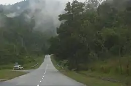 |
Perak, West Malaysia, Malaysia 5°4′N 100°58′E |
Cultural: (iii), (iv) |
398.64 (985.1); buffer zone 1,786.77 (4,415.2) | 2012 | Information
Situated in the lush Lenggong Valley, the property includes four archaeological sites in two clusters which span close to 2 million years, one of the longest records of early man in a single locality, and the oldest outside the African continent. It features open-air and cave sites with Palaeolithic tool workshops, evidence of early technology. The number of sites found in the relatively contained area suggests the presence of a fairly large, semi-sedentary population with cultural remains from the Palaeolithic, Neolithic and Metal ages. |
1396[2] |
| Gunung Mulu National Park | 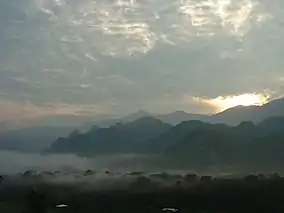 |
northern Sarawak, Borneo, Malaysia 4°8′N 114°55′E |
Natural: (vii), (viii), (ix), (x) |
52,864 (130,630) | 2000 | Information
Important both for its high biodiversity and for its karst features, Gunung Mulu National Park, on the island of Borneo in the State of Sarawak, is the most studied tropical karst area in the world. The 52,864-ha park contains seventeen vegetation zones, exhibiting some 3,500 species of vascular plants. Its palm species are exceptionally rich, with 109 species in twenty genera noted. The park is dominated by Gunung Mulu, a 2,377 m-high sandstone pinnacle. At least 295 km of explored caves provide a spectacular sight and are home to millions of cave swiftlets and bats. The Sarawak Chamber, 600 m by 415 m and 80 m high, is the largest known cave chamber in the world. |
1013[3] |
| Kinabalu Park | 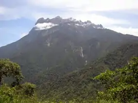 |
Sabah, Borneo, Malaysia 6°15′N 116°30′E |
Natural: (ix), (x) |
75,370 (186,200) | 2000 | Information
Kinabalu Park, in the State of Sabah on the northern end of the island of Borneo, is dominated by Mount Kinabalu (4,095 m), the highest mountain between the Himalayas and New Guinea. It has a very wide range of habitats, from rich tropical lowland and hill rainforest to tropical mountain forest, sub-alpine forest and scrub on the higher elevations. It has been designated as a Centre of Plant Diversity for Southeast Asia and is exceptionally rich in species with examples of flora from the Himalayas, China, Australia, Malaysia, as well as pan-tropical flora. |
1012[4] |
| Melaka and George Town, Historic Cities of the Straits of Malacca | 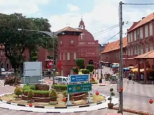 |
Melaka and George Town, Penang, West Malaysia, Malaysia 5°25′13.25″N 100°20′36″E |
Cultural: (ii), (iii), (iv) |
218.76 (540.6); buffer zone 392.84 (970.7) | 2008 | Information
Melaka and George Town, historic cities of the Straits of Malacca have developed over 500 years of trading and cultural exchanges between East and West in the Straits of Malacca. The influences of Asia and Europe have endowed the towns with a specific multicultural heritage that is both tangible and intangible. With its government buildings, churches, squares and fortifications, Melaka demonstrates the early stages of this history originating in the 15th-century Malay sultanate and the Portuguese and Dutch periods beginning in the early 16th century. Featuring residential and commercial buildings, George Town represents the British era from the end of the 18th century. The two towns constitute a unique architectural and cultural townscape without parallel anywhere in East and Southeast Asia. |
1223[5] |
Tentative list
As of 2019, there are five sites on the Tentative List for Malaysia:[6]
| Site | Image | Location | Criteria | Area ha (acre) |
Year | Description | Refs |
|---|---|---|---|---|---|---|---|
| National Park (Taman Negara) of Peninsular Malaysia | 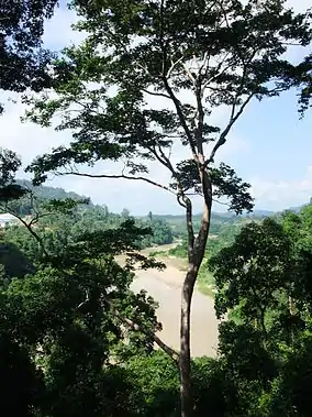 |
Pahang, Kelantan and Terengganu 4°40′N 102°25′E |
Natural: (ix), (x) |
434,351 (1,073,300) | 2014 | Information
The National Park of Peninsular Malaysia (Taman Negara), originally was gazetted as Gunung Tahan Game Reserve in 1925 and in 1939 it was declared as a National Park by the British Administrators under the name ‘King George V National Park’ under Enactment 1939, to commemorate the installation of King George V in England. Historically the three parts were enacted under the respective Malay states of Kelantan, (Taman Negara Enactment (Kelantan) 1938), Pahang (Taman Negara Enactment (Pahang) 1939) and Terengganu (Taman Negara Enactment (Terengganu) 1939), and hence came under the purview of the respective Sultans of the three states and the British High Commissioner. However, after Independence in 1957 “Taman Negara” came under the jurisdiction of the King (Yang Dipertuan Agong) and the respective Sultans of the three states. Administratively it was put under the Ministry of Natural Resources and the Environment and the administration and management came under the Department of Wildlife and National Parks, Peninsular Malaysia or PERHILITAN. The National Park was declared as ASEAN Heritage Park in the year 1984. |
5927[7] |
| FRIM Selangor Forest Park | 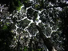 |
Selangor 3°14′N 101°38′E |
Cultural: (v) |
544 (1,340) | 2017 | Information
The FRIM Selangor Forest Park (FRIM-SFP) is a 544 ha park consisting of man-made tropical rain forest, a meandering stream (the River Kroh), waterfalls, arboreta, and botanic gardens. Today, this verdant man-made forest stands as a result of FRIM-SFP’s successful reforestation efforts that were initiated back in the 1920s. Among the most famous attractions of FRIM-SFP are the unique crown shyness phenomenon of Dryobalanops aromatica, the forest canopy walkway, the hiking and cycling trails under the shade of the giant canopy trees. The property occupies 170 ha or one third of the total area of FRIM-SFP. The property is protected by approximately 262 ha of buffer zone, and 112 ha of tertiary zone. |
6174[8] |
| Gombak Selangor Quartz Ridge | 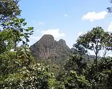 |
Gombak, Selangor 3.2396°N 101.7516°E |
Natural: (vii) |
N/A | 2017 | Information In the early 20th century the quartz ridge was called the Klang Gates Ridge. This informal geographical named remained until the 1980s when the quartz ridge was then better known as the Klang Gates Quartz Ridge or Permatang Kuarza Genting Kelang. On 24 June 2015 the Klang Gates Quartz Ridge was formally named the Gombak Selangor Quartz Ridge or Permatang Kuarza Gombak Selangor (PKGS) by the Selangor State Government. The nominated site is built entirely of quartz, a natural mineral with chemical composition of silicon dioxide (SiO2), formed when residual magma crystallized and consolidated within vertical slab of dyke as the magma forced themselves through large linear fissures within massive granitic rock known as Kuala Lumpur Granite about 200 million years ago. The most spectacular part of the quartz ridge is its protruding mid-section, which encompasses Taman Melawati, National Zoo (Zoo Negara) in the Ampang Jaya area and part of Selayang Municipal Area. From a distance, this section is said to resemble the guling ayam (cocks combs) or more dramatically, the spine of a dragon. Pseudo-karst morphology comprising at least four shapes; the dome, table, ramp and tower may be observed on the Gombak Selangor Quartz Ridge. |
6175[9] |
| Royal Belum State Park | 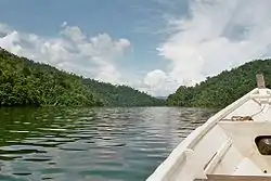 |
Perak 5°40′N 101°30′E |
Natural: (x) |
117,500 (290,000) | 2017 | Information The Royal Belum State Park, Perak Malaysia originally, was gazetted as Hutan Simpan Belum (Belum Forest Reserve) in 1971 and subsequently in 2007 it was regazetted in accordance with the Enakmen Perbadanan Taman Negeri Perak 2001 Sek. 6 (Section 6, Perak State Park Corporation Enactment 2001) as a State Park, stately called as the Crowning Glory of the Peninsula. In 2012, it was also gazzeted under the Enakmen Perhutanan Negeri Perak (Perak State Forestry Enactment) as well as National Heritage site which is the highest recognition accorded by the Government of Malaysia. In the 1970s the importance of the Belum Forest Reserve was recognised for biodiversity conservation by the Colombo Plan Report and further recommendations for biodiversity conservation was made under the Third Malaysia Plan (1976-1980) and in 1988 by the Department of Wildlife and National Parks, Peninsular Malaysia (PERHILITAN). The Royal Belum State Park borders the Halabala National Park, Thailand to the north, thus making the area of about 300,000 ha of a potential transfrontier park and the Peninsular Malaysian state of Kelantan on the east. The Royal Belum State Park was gazetted in May 2007 (Enakmen Perbadanan Taman Negeri Perak 2001 Sek. 6 No. 519) for biodiversity conservation to facilitate biodiversity education, research and ecotourism. The Royal Belum State Park is only accessible by boat via the public jetty at Pulau Banding (Banding Island) which is situated at the southern part of the State Park. The total area of the Royal Belum State Park is 117,500 ha and straddles the northern undisturbed and pristine lowland dipterocarp, hill dipterocarp and lower montane forests (up to about 1,533 m above sea level) of northern Peninsular Malaysia forming the northern and strategic component of the Central Forest Spine (CFS). The State Park is considered as one of the oldest, protected, undisturbed and pristine land mass in Peninsular Malaysia of more than 130 million years old, relics of the geological confluence of the southern Gondwanaland supercontinent and northern Laurasian supercontinent. Geographically, about 57% of its area is located in the range of 80-300 m above sea level and 41% in the range of 300-1,533 m above sea level. There is only one main river system, Sungai (River) Perak that originates from the Perak-Kelantan border in the north-east and flows southward to the Straits of Malacca at Bagan Datoh. Among the smaller rivers that are found in the State Park and drain most of the areas are Sungai Kenarong that originates on the west, Sungai Tiang and Sungai Kejar that originate on the east of the State Park, in addition to more than hundreds of smaller tributaries and streams that feed the Lake Temengor. Geologically, the Royal Belum State Park is situated on the eastern side of the Western Belt of Peninsular Malaysia, right along the tectonic boundary of two continental plates (Sibumasu and East Malaya plates). This area consists of diverse rock formations of mostly metamorphosed marine sedimentary rocks of Early Silurian-Devonian age (~ 440 to 400 m.y. ago) belonging to the Baling Group, and the Triassic granites. The igneous body intrusion that occurred in the Late Triassic age (ca. 220 m.y.) had lifted the area and became a land mass and physical landscape what we observed today. This intrusion and other related tectonic activities resulted from the collision of two supercontinental plates had shaped the area to what it is today as a metamorphed and uplifted Baling Group. This substratum has become the niche and habitats for the rich and diverse biodiversity in the State Park. |
6176[10] |
| Sungai Buloh Leprosarium | Selangor 3.222168°N 101.590881°E |
Cultural: (ii), (iv), (v), (vi) |
227 (560) | 2019 | Information
The Sungai Buloh Leprosarium, officially known as the National Leprosy Control Centre (NLCC), is located at the valley of Bukit Lagong in the state of Selangor, 25km from the capital city of Malaysia - Kuala Lumpur. It was completed in 1930. The Sungai Buloh Leprosarium has been known as one of the exceptional models in the liberation of leprosy institutions in the 20th century and also one of best treatment centers for leprosy. On top of this, the Sungai Buloh Leprosarium was also one of the key leprosy research center in the globe where some of its research, trials and experiments have greatly contributed to the treatment of the disease. The Leprosarium originally covered an area of over 562 acres, comprising more than 600 buildings in three sections. At its peak period, the patients numbered 2,440. Hence, the Sungai Buloh Leprosarium is the biggest leprosarium in the British Empire in terms of the number of patients and empirically, it was deemed as the second biggest in the world after the Culion Leprosarium in the Philippines. |
6388[11] |
Proposed Inclusion to the Tentative List
- Bujang Valley - Includes ruins of the epicenter of a Hindu-Buddhist kingdom dating back to 2,535 years ago. The site includes Sungai Batu, the oldest man-made structure to be recorded in Southeast Asia[12] UNESCO made a report in 1987 endorsing the site.[13] In 2014, some tombs of Bujang were destroyed by an urban developer, causing an international outcry against attacks on cultural heritage.[14] In 2017, the government of Malaysia announced that more research on the site is still needed, thus excluding it from the Malaysian tentative list. The government also said that Bujang's Merbok Museum and Pengkalan Bujang held historical significance to the site.[15]
- Kuala Kedah Fort - In 1987, UNESCO made a report endorsing the fort of Kuala Kedah and its buffer zone to the world heritage list.[16]
- Turtle Islands Heritage Protected Area (TIHPA) - In 1996, both the governments of Malaysia and the Philippines agreed to establish the transnational TIHPA, which comprises the Turtle Islands National Park in the Malaysian side and the Turtle Islands Wildlife Sanctuary in the Philippine side.[17] The islands in the Philippine side were inputted in UNESCO's tentative list in 2015. Malaysia has yet to input their side of the transnational site.[18]
- Historical Monuments of Kuching - In 2014, calls for Kuching's inclusion in the world heritage list were made public.[19] In 2017, a study was conducted on the possibility of Kuching to be nominated in the world heritage list.[20] In 2019, the government of Kuching announced it will create a list of sites that may be nominated to UNESCO in the future.[21]
- Niah National Park - In 2010, the government nominated the park and its caves in the world heritage list.[22] In 2019, Sarawak's government announced that they will re-submit its bid to make Niah a world heritage site.[23]
- Baturong Madai Forest Reserve - includes the Madai Cave, which is the earliest known human settlement in northern Borneo between 20,000 and 30,000 years ago.[24]
- Historical Monuments of Kota Kinabalu - the monuments date back to the colonial 19th century up to the modern 21st century.
- Danum Valley Conservation Area - the vast valley is one of the last undisturbed forests in Southeast Asia.
- Historical Monuments of Sandakan - the monuments date back between the colonial 19th century up to the modern 21st century.
- Modern Landscape of Labuan
- Royal Palaces and Monuments of Johor
- Royal Palaces and Monuments of Kedah
- Royal Palaces and Monuments of Kelantan
- Royal Palaces and Monuments of Negeri Sembilan
- Royal Palaces and Monuments of Pahang
- Royal Palaces and Monuments of Perak
- Royal Palaces and Monuments of Perlis
- Royal Palaces and Monuments of Selangor
- Royal Palaces and Monuments of Terengganu
Performance of Malaysia in UNESCO
| UNESCO List | Exclusive Entries of Malaysia | Shared/Multinational Entries Involving Malaysia | Total |
|---|---|---|---|
| UNESCO World Network of Biosphere Reserves | 2 | — | 2 |
| UNESCO World Heritage List | 4 | — | 4 |
| UNESCO Memory of the World Register | 4 | 1 | 5 |
| UNESCO Global Geoparks Network | 1 | — | 1 |
| UNESCO Creative Cities Network | 0 | — | 0 |
| UNESCO Intangible Cultural Heritage Lists | 3 | 2 | 5 |
See also
References
- "World Heritage Properties in Malaysia". UNESCO. Retrieved 31 March 2015.
- "Archaeological Heritage of the Lenggong Valley". UNESCO. Retrieved 4 July 2018.
- "Gunung Mulu National Park". UNESCO. Retrieved 4 July 2018.
- "Kinabalu Park". UNESCO. Retrieved 4 July 2018.
- "Melaka and George Town, Historic Cities of the Straits of Malacca". UNESCO. Retrieved 4 July 2018.
- "Tentative Lists: Malaysia". UNESCO. Retrieved 7 July 2020.
- "National Park (Taman Negara) of Peninsular Malaysia". UNESCO. Retrieved 4 July 2018.
- "FRIM Selangor Forest Park". UNESCO. Retrieved 4 July 2018.
- "Gombak Selangor Quartz Ridge". UNESCO. Retrieved 4 July 2018.
- "Royal Belum State Park". UNESCO. Retrieved 4 July 2018.
- "Sungai Buloh Leprosarium". UNESCO. Retrieved 7 July 2020.
- https://www.nst.com.my/nst/articles/26lembahbuj/Article/
- https://unesdoc.unesco.org/ark:/48223/pf0000078585
- https://www.bbncommunity.com/prehistoric-temple-ruin-site-applied-unesco-heritage-status-furtively-destroyed/
- https://www.freemalaysiatoday.com/category/nation/2017/08/06/ministry-more-studies-before-unesco-push-for-bujang-valley/
- https://unesdoc.unesco.org/ark:/48223/pf0000078585
- http://www.oneocean.org/ambassadors/track_a_turtle/tihpa/index.html
- https://whc.unesco.org/en/tentativelists/6008/
- http://www.theborneopost.com/2014/11/19/call-for-nomination-of-kuching-waterfront-to-become-unesco-world-heritage-site/
- https://www.thestar.com.my/metro/metro-news/2017/11/30/improving-kuchings-chances-of-receiving-unesco-recognition/
- https://www.malaymail.com/news/malaysia/2019/05/25/sarawak-eyes-several-location-in-kuching-as-unesco-heritage-sites/1756400
- https://web.archive.org/web/20121019105457/http://thestar.com.my/news/story.asp?file=%2F2011%2F8%2F11%2Fsarawak%2F9276945&sec=sarawak
- https://www.malaymail.com/news/malaysia/2019/01/22/sarawak-to-re-submit-bid-to-make-niah-caves-unesco-heritage-site/1715263
- http://www.wildlife.sabah.gov.my/?q=en/content/madai-cave

Lists of World Heritage Sites in Asia | ||
|---|---|---|
| Northern and Central Asia | ||
| Western Asia (including Arab States) | ||
| Eastern Asia | ||
| Southern Asia | ||
| Southeast Asia | ||
| Locations | ||
|---|---|---|
| Related | ||