List of listed buildings in Balquhidder, Stirling
List
| Name | Location | Date Listed | Grid Ref. [note 1] | Geo-coordinates | Notes | LB Number [note 2] | Image |
|---|---|---|---|---|---|---|---|
| Edinchip House With Terraces, Lodge, Bridge, Gardener's Cottage, Kennels, Former Steading And Other Ancillary Buildings | 56°22′23″N 4°18′20″W | Category C(S) | 50340 |  | |||
| Strathyre, Coire Buidhe And St Ola | 56°19′25″N 4°19′43″W | Category C(S) | 50345 | | |||
| Strathyre, Monument To Dugald Buchanan | 56°19′27″N 4°19′44″W | Category C(S) | 50348 | | |||
| Stronvar Bridge Over River Balvag | 56°21′18″N 4°22′21″W | Category B | 4187 | | |||
| Strathyre, Bridge Over The River Balvag | 56°19′31″N 4°19′47″W | Category B | 4194 | | |||
| Strathyre, Immervoulin | 56°19′12″N 4°19′44″W | Category C(S) | 4195 | | |||
| Glen Ogle, Bridge On A85 Over Allt An Sput Dhuibh | 56°24′03″N 4°18′05″W | Category C(S) | 4136 | | |||
| Kingshouse, Signpost | 56°21′13″N 4°19′31″W | Category C(S) | 50342 | | |||
| Balquhidder, Kirkton Bridge | 56°21′27″N 4°22′22″W | Category C(S) | 4186 | | |||
| Imirriabhach, Burial Enclosure | 56°20′22″N 4°29′32″W | Category C(S) | 4192 | | |||
| Glen Ogle, 3-Arch Railway Bridge | 56°24′30″N 4°19′05″W | Category C(S) | 229 | | |||
| Balquhidder, Ardachaidh | 56°21′26″N 4°22′20″W | Category C(S) | 50336 | | |||
| Balquhidder, Former School And Schoolhouse Including Boundary Walls | 56°21′28″N 4°22′11″W | Category C(S) | 50338 | | |||
| Strathyre, Corriegowrie | 56°19′29″N 4°19′43″W | Category C(S) | 50346 | | |||
| Lochearnhead, St Angus Episcopal Church | 56°22′49″N 4°17′14″W | Category B | 44186 | | |||
| Glen Ogle Viaduct | 56°24′54″N 4°19′46″W | Category B | 4141 | | |||
| Craigruie With Walled Garden And Other Ancillary Structures | 56°20′56″N 4°25′55″W | Category B | 50339 | | |||
| Lochearnhead, Craggan, Druidfield Croft | 56°22′45″N 4°17′25″W | Category C(S) | 50343 | | |||
| Strathyre, Dochfour And Mandalay | 56°19′32″N 4°19′39″W | Category C(S) | 50347 | | |||
| Stronvar House | 56°21′08″N 4°22′56″W | Category B | 4188 | | |||
| Stronvar Farm | 56°21′07″N 4°23′02″W | Category B | 4189 | | |||
| Glen Ogle, Bridge On A85 Over Ogle Burn Near Glen Ogle Farm | 56°23′44″N 4°17′42″W | Category C(S) | 4134 | | |||
| Glen Ogle, Bridge On A85 Glen Ogle, Bridge Over Ogle Burn On Former Military Road 1Km North Of Glenogle Farm | 56°23′55″N 4°17′52″W | Category C(S) | 4135 | | |||
| Glen Ogle, Bridge Over Ogle Burn On Former Military Road Near Parish Boundary | 56°25′01″N 4°19′44″W | Category C(S) | 4142 | | |||
| Balquhidder Parish Church And Churchyard | 56°21′29″N 4°22′18″W | Category B | 4157 | | |||
| Glen Buckie, Bridge Near Ballimore Farm Over Calair Burn On Road To Immeroin | 56°19′36″N 4°22′47″W | Category C(S) | 50341 | | |||
| Calair Bridge Over Calair Burn | 56°21′09″N 4°22′06″W | Category C(S) | 4190 | | |||
| Auchtubh, Macgregor Murray Mausoleum With Gatepiers, Gates And Boundary Wall | 56°21′21″N 4°20′23″W | Category B | 4191 | | |||
| Edinample Castle With Ancillary Building, Bothy And Garden Walls | 56°22′32″N 4°15′56″W | Category A | 4198 | 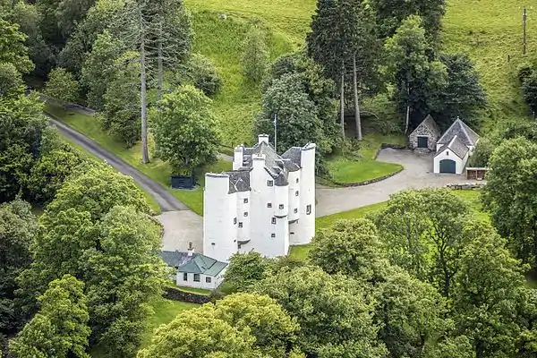 | |||
| Glen Ogle, Bridge On A85 | 56°24′37″N 4°18′46″W | Category C(S) | 4138 | | |||
| Balquhidder, Creag An Tuirc House | 56°21′29″N 4°22′06″W | Category C(S) | 49500 | | |||
| Edinchip Footbridge Over Former Callander And Oban Railway | 56°22′25″N 4°18′21″W | Category B | 43905 | | |||
| Strathyre, Tigh-Na-Sheann | 56°19′38″N 4°19′58″W | Category C(S) | 4193 | | |||
| Edinchip Viaduct Over Kendrum Burn | 56°22′20″N 4°18′29″W | Category B | 4196 | | |||
| Edinample Mausoleum | 56°22′25″N 4°15′55″W | Category B | 4199 | | |||
| Glen Ogle, Bridge On A85 | 56°24′27″N 4°18′29″W | Category C(S) | 4137 | | |||
| Balquhidder, The Library Tea Room | 56°21′26″N 4°22′20″W | Category C(S) | 50337 | | |||
| Lochearnhead, Village Shop On A84 | 56°23′06″N 4°17′15″W | Category C(S) | 50344 | |
Key
The scheme for classifying buildings in Scotland is:
- Category A: "buildings of national or international importance, either architectural or historic; or fine, little-altered examples of some particular period, style or building type."[1]
- Category B: "buildings of regional or more than local importance; or major examples of some particular period, style or building type, which may have been altered."[1]
- Category C: "buildings of local importance; lesser examples of any period, style, or building type, as originally constructed or moderately altered; and simple traditional buildings which group well with other listed buildings."[1]
In March 2016 there were 47,288 listed buildings in Scotland. Of these, 8% were Category A, and 50% were Category B, with the remaining 42% being Category C.[2]
Notes
- Sometimes known as OSGB36, the grid reference (where provided) is based on the British national grid reference system used by the Ordnance Survey.
• "Guide to National Grid". Ordnance Survey. Retrieved 2007-12-12.
• "Get-a-map". Ordnance Survey. Retrieved 2007-12-17. - Historic Environment Scotland assign a unique alphanumeric identifier to each designated site in Scotland, for listed buildings this always begins with "LB", for example "LB12345".
References
- All entries, addresses and coordinates are based on data from Historic Scotland. This data falls under the Open Government Licence
- "What is Listing?". Historic Environment Scotland. Retrieved 29 May 2018.
- Scotland's Historic Environment Audit 2016 (PDF). Historic Environment Scotland and the Built Environment Forum Scotland. pp. 15–16. Retrieved 29 May 2018.
This article is issued from Wikipedia. The text is licensed under Creative Commons - Attribution - Sharealike. Additional terms may apply for the media files.