List of listed buildings in Dunblane And Lecropt
List
| Name | Location | Date Listed | Grid Ref. [note 1] | Geo-coordinates | Notes | LB Number [note 2] | Image |
|---|---|---|---|---|---|---|---|
| Keir, Footbridge Over Home Farm Drive | 56°10′01″N 3°58′56″W | Category B | 3972 |  | |||
| Keir, Walled Garden | 56°10′02″N 3°59′01″W | Category B | 3977 | | |||
| Kippenross Bridge Over Allan Water | 56°10′36″N 3°57′48″W | Category C(S) | 3932 | | |||
| Keir House, Terrace, Steps And Terminal Feature | 56°09′58″N 3°59′02″W | Category C(S) | 170 | | |||
| Mortuary Chapel Of Campbells Of Aberuchill And Kilbride And Surrounding Graveyard Near Torrance | 56°12′04″N 4°00′27″W | Category C(S) | 175 | | |||
| Kilbryde Walled Garden | 56°12′34″N 4°00′31″W | Category C(S) | 3955 | | |||
| Keir, Avenue Bridge Over Home Farm Drive | 56°10′02″N 3°58′54″W | Category B | 3973 | | |||
| Queen Victoria School, Dunblane | 56°12′03″N 3°57′11″W | Category A | 3986 | | |||
| Keir House, Stud House | 56°10′09″N 3°58′46″W | Category C(S) | 3917 | | |||
| Keir, Old Lecropt Churchyard | 56°09′30″N 3°57′52″W | Category B | 3922 | | |||
| Stonehill, Farmhouse | 56°11′08″N 3°55′56″W | Category C(S) | 3927 | | |||
| Keir House, Lower Glen Section | 56°09′50″N 3°59′25″W | Category B | 3941 | | |||
| Keir House, Bathing House | 56°09′55″N 3°59′18″W | Category B | 3942 | | |||
| Lecropt Manse | 56°09′31″N 3°57′32″W | Category B | 174 | | |||
| Keir, Sundial | 56°09′58″N 3°59′04″W | Category B | 3969 | | |||
| Old Glassingal House | 56°13′05″N 3°56′38″W | Category B | 3994 | | |||
| Old Kippenross | 56°10′32″N 3°57′41″W | Category B | 3931 | | |||
| Keir West Terrace | 56°09′58″N 3°59′02″W | Category B | 3936 | | |||
| Lecropt Church | 56°09′31″N 3°57′54″W | Category A | 173 | | |||
| Keir, Garden Seat Over S. Tunnelmouth | 56°10′01″N 3°58′57″W | Category C(S) | 3971 | | |||
| Garden House, Glassingal | 56°13′04″N 3°56′19″W | Category B | 3992 | | |||
| North Lodge, Glassingal | 56°13′01″N 3°56′51″W | Category B | 3993 | | |||
| Kinbuck Bridge Over Allan Water | 56°13′32″N 3°57′04″W | Category B | 3998 | 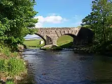 | |||
| Keir House, Keir Home Farm | 56°10′14″N 3°58′42″W | Category A | 3918 | | |||
| Sheriffmuir Inn | 56°11′50″N 3°53′31″W | Category C(S) | 3925 | | |||
| Kippenross House | 56°10′37″N 3°57′32″W | Category B | 3928 | | |||
| Railway Viaduct At Old Mill Of Keir, S. Of Kippenross House Tunnelmouth To N | 56°10′31″N 3°57′35″W | Category C(S) | 3934 | | |||
| Keir House, Ice House | 56°10′07″N 3°58′51″W | Category B | 3943 | | |||
| Arnhall Castle | 56°09′51″N 3°59′33″W | Category B | 171 | | |||
| Cromlix House Including Game Larder, Ancillary Building, Gatepiers And Garden Boundary Walls | 56°13′54″N 3°57′59″W | Category C(S) | 50619 | | |||
| Keir, Terracing And Column To East | 56°10′00″N 3°58′53″W | Category C(S) | 3975 | | |||
| Memorial Chapel, Dunblane | 56°12′00″N 3°57′10″W | Category A | 3987 | | |||
| Infirmary, Dunblane | 56°11′59″N 3°57′06″W | Category C(S) | 3988 | | |||
| Gateside, Octagon | 56°12′55″N 3°56′14″W | Category C(S) | 3995 | | |||
| Lecropt School | 56°09′28″N 3°57′27″W | Category B | 3908 | | |||
| Kilbryde Castle | 56°12′34″N 4°00′26″W | Category B | 3909 | | |||
| Keir, Tunnel And Terrace Over | 56°10′01″N 3°58′57″W | Category B | 3970 | | |||
| Queen Victoria School, Dunblane, Wall And Gates | 56°12′07″N 3°57′16″W | Category C(S) | 3990 | | |||
| Cromlix House, Sundial And Flanking Pair Of Gatepiers (Formerly Fireplace Jambs) | 56°13′54″N 3°57′59″W | Category A | 3997 | 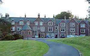 | |||
| Kilbryde Stable Block | 56°12′36″N 4°00′30″W | Category B | 3910 | | |||
| Keir House, Water House | 56°10′09″N 3°58′57″W | Category C(S) | 3915 | | |||
| Keir, South Lodge | 56°10′07″N 3°58′24″W | Category A | 3921 | | |||
| Keir House, Archway South Of, Carrying West Drive | 56°09′58″N 3°58′54″W | Category B | 3940 | | |||
| Keir House Avenue Bridge William Stirling Cenotaph | 56°10′02″N 3°58′54″W | Category B | 3974 | | |||
| Keir, Encircling Wall Of Eastern Portion Of Gardens Running From Keir House To Stud House A) Salve Gateway B) Gateway & Stairs On N. Lodge Drive C) Swan Gateway, Stud House | 56°10′04″N 3°58′27″W | Category B | 3976 | | |||
| Ryland (Formerly Kippendavie) Lodge, Dunblane | 56°11′50″N 3°56′46″W | Category C(S) | 3985 | | |||
| Keir House, Lodge | 56°10′17″N 3°58′42″W | Category B | 3919 | | |||
| Keir House North Lodge | 56°10′05″N 3°58′10″W | Category C(S) | 3920 | | |||
| Railway Viaduct At Old Mill Of Keir, S. Of Kippenross House | 56°10′30″N 3°57′35″W | Category B | 3933 | | |||
| Lecropt Church Cottage | 56°09′29″N 3°57′51″W | Category C(S) | 47649 | | |||
| Keir House Walled Garden Screen Wall And Gateway To N.W | 56°10′05″N 3°59′04″W | Category B | 3978 | | |||
| Keir House Water Garden | 56°09′58″N 3°59′17″W | Category C(S) | 3979 | | |||
| Headmaster's House, Dunblane | 56°12′07″N 3°57′13″W | Category C(S) | 3989 | | |||
| Glassingal House, South Lodge | 56°12′52″N 3°56′55″W | Category B | 3991 | | |||
| Wester Cambushinnie, Cottar House And Bothy | 56°14′12″N 3°57′10″W | Category C(S) | 3999 | | |||
| Keir House, Gardens House | 56°09′59″N 3°58′59″W | Category C(S) | 3916 | | |||
| Keir, Bairnsburn | 56°09′40″N 3°58′27″W | Category C(S) | 3923 | | |||
| Keir, Old Walled Garden West Of (Camey Bank) | 56°09′38″N 3°59′11″W | Category C(S) | 3924 | | |||
| Sheriffmuir, Macrae Memorial | 56°11′43″N 3°54′37″W | Category B | 3926 | | |||
| Kippenross Sundial | 56°10′36″N 3°57′31″W | Category C(S) | 3929 | | |||
| Kippenross Walled Garden | 56°10′33″N 3°57′45″W | Category B | 3930 | | |||
| Keir House | 56°09′58″N 3°58′58″W | Category A | 3935 | 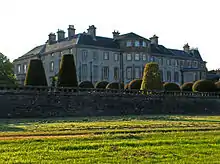 |
Key
The scheme for classifying buildings in Scotland is:
- Category A: "buildings of national or international importance, either architectural or historic; or fine, little-altered examples of some particular period, style or building type."[1]
- Category B: "buildings of regional or more than local importance; or major examples of some particular period, style or building type, which may have been altered."[1]
- Category C: "buildings of local importance; lesser examples of any period, style, or building type, as originally constructed or moderately altered; and simple traditional buildings which group well with other listed buildings."[1]
In March 2016 there were 47,288 listed buildings in Scotland. Of these, 8% were Category A, and 50% were Category B, with the remaining 42% being Category C.[2]
Notes
- Sometimes known as OSGB36, the grid reference (where provided) is based on the British national grid reference system used by the Ordnance Survey.
• "Guide to National Grid". Ordnance Survey. Retrieved 12 December 2007.
• "Get-a-map". Ordnance Survey. Retrieved 17 December 2007. - Historic Environment Scotland assign a unique alphanumeric identifier to each designated site in Scotland, for listed buildings this always begins with "LB", for example "LB12345".
References
- All entries, addresses and coordinates are based on data from Historic Scotland. This data falls under the Open Government Licence
- "What is Listing?". Historic Environment Scotland. Retrieved 29 May 2018.
- Scotland's Historic Environment Audit 2016 (PDF). Historic Environment Scotland and the Built Environment Forum Scotland. pp. 15–16. Retrieved 29 May 2018.
This article is issued from Wikipedia. The text is licensed under Creative Commons - Attribution - Sharealike. Additional terms may apply for the media files.