List of listed buildings in Kilmadock, Stirling
List
| Name | Location | Date Listed | Grid Ref. [note 1] | Geo-coordinates | Notes | LB Number [note 2] | Image |
|---|---|---|---|---|---|---|---|
| 12-22 Teith Street Deanston Mill Deanston | 56°11′26″N 4°04′27″W | Category C(S) | 8239 |  | |||
| Cambusmore - Lodge And Gates | 56°13′45″N 4°10′30″W | Category B | 8241 | | |||
| Gartincaber House | 56°10′30″N 4°05′56″W | Category B | 8255 | | |||
| Daldorn ("Kames" On Map), Farmhouse | 56°12′07″N 4°08′48″W | Category B | 8218 | | |||
| Deanston Mill - Deanston Cottages 24-34 Teith Road | 56°11′27″N 4°04′28″W | Category C(S) | 8235 | | |||
| Blair Drummond North Lodge ("Chain Lodge") | 56°11′07″N 4°03′43″W | Category B | 8249 | | |||
| Lanrick Castle | 56°12′09″N 4°07′01″W | Category B | 8215 | | |||
| Argaty Stables | 56°12′16″N 4°02′15″W | Category B | 8226 | | |||
| Deanston Lodge, Gates And Wall To B 8032 | 56°11′11″N 4°03′59″W | Category B | 8229 | | |||
| Deanston Mill, Old Spinning Mill | 56°11′23″N 4°04′17″W | Category A | 8230 | 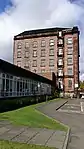 | |||
| Deanston Mill - Deanston Cottages 2-12 Teith Road | 56°11′26″N 4°04′25″W | Category C(S) | 8234 | | |||
| Deanston Mill - Deanston Cottages 36-44 Teith Road | 56°11′29″N 4°04′33″W | Category C(S) | 8236 | | |||
| Deanston Mills, Weir | 56°11′56″N 4°05′31″W | Category A | 47650 | | |||
| Deanston School Teith Street | 56°11′25″N 4°04′24″W | Category C(S) | 13674 | | |||
| Lanrick "Cave" | 56°12′14″N 4°07′20″W | Category B | 8242 | | |||
| Lanrick Macgregor Monument | 56°12′03″N 4°07′22″W | Category A | 8244 | | |||
| Lanrick South (Main) Lodge | 56°11′39″N 4°05′59″W | Category B | 8246 | | |||
| Lanrick North Lodge | 56°12′17″N 4°06′50″W | Category C(S) | 8247 | | |||
| Braendam House - Lodge | 56°11′29″N 4°10′26″W | Category C(S) | 8259 | | |||
| Easter Coillechat, Old Bridge Over Coillechat Burn | 56°12′20″N 4°07′08″W | Category B | 8217 | | |||
| Doune Lodge, Lodge | 56°12′08″N 4°05′04″W | Category B | 8221 | | |||
| Doune Garden House, N. Of Walled Garden | 56°12′27″N 4°04′42″W | Category B | 8224 | | |||
| Lanrick Kennels | 56°12′07″N 4°07′15″W | Category C(S) | 8243 | | |||
| Lanrick Gateway, Approx. 300 Yds. S.E. Of Upper Lanrick | 56°11′53″N 4°07′39″W | Category B | 8245 | | |||
| Inverardoch, Mortuary Chapel | 56°10′45″N 4°02′25″W | Category C(S) | 8252 | | |||
| Doune Stable Block | 56°12′12″N 4°05′08″W | Category A | 8220 | | |||
| Deanston Mill - Deanston Cottages 1-7 | 56°11′26″N 4°04′22″W | Category C(S) | 8232 | | |||
| Deanston Mill - Deanston Cottages 46-56 Teith Road | 56°11′29″N 4°04′35″W | Category C(S) | 8237 | | |||
| Mains Of Inverardoch, Doocot And Part Of Steading Adjoining | 56°10′55″N 4°02′07″W | Category B | 13677 | | |||
| Inverardoch, Ruins Of Stables | 56°10′58″N 4°02′45″W | Category C(S) | 8251 | | |||
| Row | 56°10′12″N 4°01′40″W | Category C(S) | 8253 | | |||
| Hillside Of Row | 56°10′28″N 4°00′32″W | Category C(S) | 8254 | | |||
| Gartincaber Tower | 56°10′55″N 4°05′59″W | Category B | 8256 | | |||
| Kilmadock, Cottages | 56°11′47″N 4°05′07″W | Category B | 8214 | | |||
| Lanrick Stables | 56°12′03″N 4°06′45″W | Category B | 8216 | | |||
| Doune Walled Garden | 56°12′22″N 4°04′39″W | Category C(S) | 8222 | | |||
| Bridge Over Annet Burn At Bridge Of Campus, Original Section Only | 56°12′08″N 4°05′11″W | Category B | 8223 | | |||
| Deanston Mill, Old Weaving Shed | 56°11′21″N 4°04′19″W | Category A | 8231 | | |||
| Doune Castle | 56°11′07″N 4°03′01″W | Category A | 6714 | 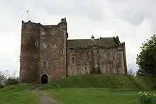 | |||
| Lanrick Bridge | 56°12′10″N 4°06′50″W | Category B | 13675 | | |||
| Bridgend Of Teith | 56°11′13″N 4°03′31″W | Category B | 13676 | | |||
| Cambusmore | 56°13′45″N 4°10′40″W | Category C(S) | 8240 | | |||
| Braendam House | 56°11′27″N 4°11′03″W | Category B | 8258 | | |||
| Argaty House | 56°12′14″N 4°02′15″W | Category B | 8225 | | |||
| Deanston Mill - Deanston Cottages 8-11 | 56°11′27″N 4°04′23″W | Category C(S) | 8233 | | |||
| The Old School Deanston Mill | 56°11′24″N 4°04′21″W | Category C(S) | 8238 | | |||
| Wester Broich, Farmhouse | 56°11′25″N 4°06′20″W | Category C(S) | 13673 | | |||
| Gartincaber House - Stables | 56°10′27″N 4°05′48″W | Category C(S) | 8257 | | |||
| Wester Torrie, Steading | 56°12′43″N 4°10′40″W | Category C(S) | 8260 | | |||
| Doune Lodge (Now Known As Doune Park) | 56°12′16″N 4°04′50″W | Category B | 8219 | | |||
| Deanston House | 56°11′17″N 4°04′26″W | Category B | 8228 | | |||
| Watston | 56°10′58″N 4°04′16″W | Category B | 8250 | | |||
| Kilmadock Church (Ruins) And Graveyard | 56°11′50″N 4°05′10″W | Category B | 8213 | | |||
| Old Newton House, Doune | 56°11′12″N 4°02′44″W | Category A | 8227 | |
Key
The scheme for classifying buildings in Scotland is:
- Category A: "buildings of national or international importance, either architectural or historic; or fine, little-altered examples of some particular period, style or building type."[1]
- Category B: "buildings of regional or more than local importance; or major examples of some particular period, style or building type, which may have been altered."[1]
- Category C: "buildings of local importance; lesser examples of any period, style, or building type, as originally constructed or moderately altered; and simple traditional buildings which group well with other listed buildings."[1]
In March 2016 there were 47,288 listed buildings in Scotland. Of these, 8% were Category A, and 50% were Category B, with the remaining 42% being Category C.[2]
Notes
- Sometimes known as OSGB36, the grid reference (where provided) is based on the British national grid reference system used by the Ordnance Survey.
• "Guide to National Grid". Ordnance Survey. Retrieved 2007-12-12.
• "Get-a-map". Ordnance Survey. Retrieved 2007-12-17. - Historic Environment Scotland assign a unique alphanumeric identifier to each designated site in Scotland, for listed buildings this always begins with "LB", for example "LB12345".
References
- All entries, addresses and coordinates are based on data from Historic Scotland. This data falls under the Open Government Licence
- "What is Listing?". Historic Environment Scotland. Retrieved 29 May 2018.
- Scotland's Historic Environment Audit 2016 (PDF). Historic Environment Scotland and the Built Environment Forum Scotland. pp. 15–16. Retrieved 29 May 2018.
This article is issued from Wikipedia. The text is licensed under Creative Commons - Attribution - Sharealike. Additional terms may apply for the media files.