List of listed buildings in St Ninians, Stirling
List
| Name | Location | Date Listed | Grid Ref. [note 1] | Geo-coordinates | Notes | LB Number [note 2] | Image |
|---|---|---|---|---|---|---|---|
| Buckieburn Church | 56°02′35″N 4°00′19″W | Category B | 15272 |  | |||
| Bruce's Castle | 56°04′10″N 3°50′15″W | Category B | 15284 | | |||
| Cambusbarron, North Third Water Filter Plant, Former Water Pump House | 56°05′11″N 3°59′55″W | Category B | 50839 | | |||
| Fallin, Polmaise Estate, Benny's Bridge | 56°06′31″N 3°52′37″W | Category C(S) | 44927 | | |||
| Nos 9, 11, 13 And 15 The Brae, Bannockburn | 56°05′29″N 3°55′01″W | Category B | 15273 | | |||
| No 19 The Brae, Bannockburn | 56°05′29″N 3°55′02″W | Category B | 15274 | | |||
| Plean House | 56°03′30″N 3°52′51″W | Category C(S) | 15281 | | |||
| The Old School House Coal Wynd Bannockburn | 56°05′26″N 3°55′01″W | Category B | 15286 | | |||
| Our Lady And St Ninian's Rc Church And Presbytery Quakerfield Road, Bannockburn | 56°05′24″N 3°54′35″W | Category C(S) | 15289 | | |||
| Seton Lodge | 56°06′52″N 4°00′21″W | Category B | 15297 | | |||
| Borrowmeadow | 56°07′22″N 3°54′42″W | Category B | 13860 | | |||
| Howietoun Fishery, Sauchiemill, Former Mill | 56°04′20″N 3°57′03″W | Category B | 49463 | 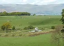 | |||
| Milnholm Hatchery | 56°03′59″N 3°57′16″W | Category A | 15275 | | |||
| Nos 42/50 Main Street And 1, 3, 5, 7 The Brae, Bannockburn | 56°05′28″N 3°55′00″W | Category B | 15290 | | |||
| Dovecot, Old Sauchie | 56°04′29″N 3°57′35″W | Category B | 15300 | | |||
| Sundial | 56°03′51″N 3°55′51″W | Category B | 15304 | | |||
| Muirmill By Carron Bridge | 56°01′52″N 4°02′33″W | Category B | 15307 | | |||
| Bannockburn 33 Main Street Former James Wilson Academy | 56°05′27″N 3°54′52″W | Category B | 15309 | 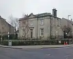 | |||
| Sundial | 56°04′49″N 3°58′20″W | Category B | 15301 | | |||
| Milnholm Hatchery, Footbridge Over Loch Coulter Burn | 56°03′59″N 3°57′17″W | Category C(S) | 15276 | | |||
| Stables, Plean House | 56°03′27″N 3°53′01″W | Category C(S) | 15282 | | |||
| Stewarthall Stableyard | 56°06′50″N 3°53′16″W | Category C(S) | 15283 | | |||
| "New Road" Bridge, Bannockburn | 56°05′32″N 3°54′55″W | Category B | 15287 | 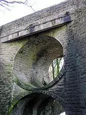 | |||
| Old Bridge, Bannockburn | 56°05′31″N 3°55′05″W | Category B | 15292 | 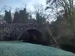 | |||
| Sundial | 56°04′53″N 3°58′19″W | Category B | 15302 | | |||
| Whins Of Milton, Milton Grove, Milton Mill Including Water Wheel, Internal Workings And Lade | 56°05′15″N 3°55′40″W | Category B | 50157 | | |||
| Bannockburn House | 56°04′40″N 3°54′55″W | Category A | 15277 | 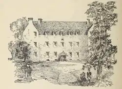 | |||
| Plean (farmhouse) | 56°04′22″N 3°52′50″W | Category C(S) | 15280 | | |||
| William Simpson's Home And Walled Garden, Plean | 56°03′32″N 3°51′55″W | Category B | 15285 | | |||
| Craigforth House | 56°07′51″N 3°58′23″W | Category B | 15294 | | |||
| Auchenbowie House | 56°03′52″N 3°55′52″W | Category A | 15303 | | |||
| Bannockburn, 1A Main Street | 56°05′26″N 3°54′48″W | Category C(S) | 13861 | | |||
| Fallin, Polmaise Estate, Bridge At Ns 8337 9218 | 56°06′29″N 3°52′37″W | Category B | 44928 | | |||
| Royal George Mill, Bannockburn | 56°05′32″N 3°54′57″W | Category B | 19737 | 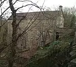 | |||
| Allan Church Bannockburn | 56°05′28″N 3°54′50″W | Category B | 15271 | | |||
| Lochend Farm | 56°02′47″N 3°59′39″W | Category C(S) | 15288 | | |||
| Touch House (Mrs Buchanan) | 56°06′40″N 4°00′23″W | Category A | 15295 | | |||
| Gartur House | 56°06′21″N 3°59′19″W | Category B | 15298 | | |||
| Old Sauchie | 56°04′21″N 3°57′47″W | Category B | 15299 | | |||
| Bannockburn 9 New Road, View Vale | 56°05′29″N 3°54′52″W | Category B | 15310 | 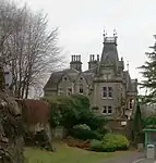 | |||
| Plean Tower | 56°03′42″N 3°50′55″W | Category B | 13859 | 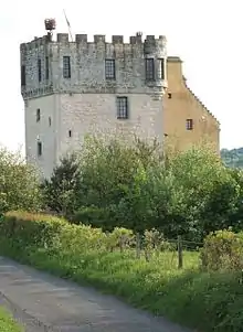 | |||
| Cambusbarron, Hayford Mills | 56°06′45″N 3°58′16″W | Category A | 19117 | | |||
| Cambusbarron, Hayford House | 56°06′48″N 3°58′10″W | Category B | 19118 | | |||
| Gatepiers, Bannockburn House | 56°04′43″N 3°54′55″W | Category B | 15279 | | |||
| Dovecot, Touch | 56°06′48″N 4°00′30″W | Category B | 15296 | | |||
| Fallin Wooden Railway Bridge | 56°06′17″N 3°53′03″W | Category B | 15308 | | |||
| Dovecot, Bannockburn House | 56°04′44″N 3°54′43″W | Category B | 15278 | | |||
| Old Bridge Chartershall | 56°05′23″N 3°56′32″W | Category B | 15305 | 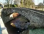 | |||
| Howietoun Fishery | 56°04′22″N 3°57′12″W | Category A | 15306 | | |||
| Bannockburn, Rotunda, Memorial Cairn, Flagpole And Statue Of King Robert I | 56°05′38″N 3°56′19″W | Category A | 49860 | 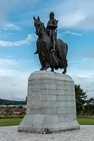 |
Key
The scheme for classifying buildings in Scotland is:
- Category A: "buildings of national or international importance, either architectural or historic; or fine, little-altered examples of some particular period, style or building type."[1]
- Category B: "buildings of regional or more than local importance; or major examples of some particular period, style or building type, which may have been altered."[1]
- Category C: "buildings of local importance; lesser examples of any period, style, or building type, as originally constructed or moderately altered; and simple traditional buildings which group well with other listed buildings."[1]
In March 2016 there were 47,288 listed buildings in Scotland. Of these, 8% were Category A, and 50% were Category B, with the remaining 42% being Category C.[2]
Notes
- Sometimes known as OSGB36, the grid reference (where provided) is based on the British national grid reference system used by the Ordnance Survey.
• "Guide to National Grid". Ordnance Survey. Retrieved 2007-12-12.
• "Get-a-map". Ordnance Survey. Retrieved 2007-12-17. - Historic Environment Scotland assign a unique alphanumeric identifier to each designated site in Scotland, for listed buildings this always begins with "LB", for example "LB12345".
References
- All entries, addresses and coordinates are based on data from Historic Scotland. This data falls under the Open Government Licence
- "What is Listing?". Historic Environment Scotland. Retrieved 29 May 2018.
- Scotland's Historic Environment Audit 2016 (PDF). Historic Environment Scotland and the Built Environment Forum Scotland. pp. 15–16. Retrieved 29 May 2018.
This article is issued from Wikipedia. The text is licensed under Creative Commons - Attribution - Sharealike. Additional terms may apply for the media files.