List of listed buildings in Dunblane
List
| Name | Location | Date Listed | Grid Ref. [note 1] | Geo-coordinates | Notes | LB Number [note 2] | Image |
|---|---|---|---|---|---|---|---|
| 1 Sinclair Street | 56°11′21″N 3°57′49″W | Category B | 26381 |  | |||
| 3 Sinclair Street | 56°11′21″N 3°57′48″W | Category C(S) | 26383 | | |||
| High Street, St Blane's Church (Church Of Scotland) | 56°11′21″N 3°57′47″W | Category B | 26386 | | |||
| 61 High Street Including Gatepiers | 56°11′17″N 3°57′53″W | Category B | 26395 | | |||
| Perth Road, Ledcameroch Including Stables, Stable Yard Wall And Walled Garden | 56°11′39″N 3°57′15″W | Category C(S) | 26427 | | |||
| Braeport, Gigha | 56°11′26″N 3°57′52″W | Category C(S) | 48942 | | |||
| Perth Road, Kincairn, Cairndow And Rosebank Including Boundary Wall | 56°11′21″N 3°57′27″W | Category C(S) | 48961 | | |||
| The Cross, The Manse Coach House, Gatepiers And Boundary Wall | 56°11′20″N 3°57′52″W | Category C(S) | 26370 | | |||
| 86-88 (Even Nos) High Street | 56°11′18″N 3°57′50″W | Category C(S) | 26389 | | |||
| Allan Water, Dunblane Railway Viaduct | 56°11′28″N 3°58′04″W | Category B | 26425 | | |||
| 2-14 (Even Nos) High Street | 56°11′12″N 3°57′49″W | Category C(S) | 48956 | | |||
| 30-34 (Even Nos) High Street | 56°11′15″N 3°57′50″W | Category C(S) | 48957 | | |||
| Perth Road, St Mary's Cottage Including Boundary Wall | 56°11′17″N 3°57′30″W | Category C(S) | 48962 | | |||
| High Street, Old Sheriff Court House | 56°11′20″N 3°57′50″W | Category C(S) | 26390 | | |||
| 49 High Street Including Boundary Wall | 56°11′16″N 3°57′51″W | Category C(S) | 26396 | 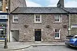 | |||
| 22 And 24 High Street | 56°11′14″N 3°57′50″W | Category C(S) | 26398 | | |||
| Braeport, Braeport Community Centre Including Boundary Wall | 56°11′26″N 3°57′51″W | Category C(S) | 26407 | | |||
| Perth Road, Dunblane Hyrdo Hotel Including Hydro Lodge, Newton Cottage, Gatepiers And Boundary Wall | 56°11′23″N 3°57′11″W | Category B | 26409 | | |||
| Stirling Road, Stirling Arms Including Boundary Wall | 56°11′11″N 3°57′50″W | Category B | 26414 | | |||
| Mill Row, Allan Cottage | 56°11′13″N 3°57′51″W | Category C(S) | 26415 | | |||
| Mill Row, Allanside Including Boundary Wall | 56°11′13″N 3°57′52″W | Category C(S) | 26416 | | |||
| Claredon Place, Church Of The Holy Family, Roman Catholic Church Including, Presbytery, Church Hall And Boundary Wall | 56°10′59″N 3°57′59″W | Category B | 26422 | 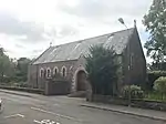 | |||
| Springbank Gardens, 1-12 (Inclusive), 14-30 (Inclusive) Springbank Mill Including Former School House | 56°11′30″N 3°58′14″W | Category B | 26426 | 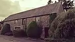 | |||
| Kirk Street, Cockburn House | 56°11′21″N 3°57′50″W | Category B | 26374 | | |||
| 16-18 (Even Nos) High Street | 56°11′13″N 3°57′50″W | Category C(S) | 26400 | | |||
| The Crescent, Glenluss Including Boundary Wall And Gatepiers | 56°11′14″N 3°57′14″W | Category B | 26412 | | |||
| 7 Stirling Road | 56°11′10″N 3°57′54″W | Category B | 26419 | | |||
| Claredon Place, Fernbank Including Gatepiers And Boundary Wall | 56°11′02″N 3°58′01″W | Category B | 26421 | | |||
| 124 And 126 High Street, Former Dunblane Free Church | 56°11′19″N 3°57′46″W | Category C(S) | 26428 | | |||
| The Cross, Municipal Buildings | 56°11′20″N 3°57′51″W | Category C(S) | 48945 | | |||
| 27 And 29 High Street Including Vaulted Basement | 56°11′15″N 3°57′52″W | Category C(S) | 48952 | | |||
| 57 And 59 High Street | 56°11′17″N 3°57′52″W | Category C(S) | 48954 | | |||
| Ramoyle, Ramoyle House | 56°11′34″N 3°57′37″W | Category C(S) | 48963 | | |||
| Station Road, Dunblane Railway Station Including Original Footbridge | 56°11′09″N 3°57′56″W | Category C(S) | 48964 | | |||
| The Cross, Cross Cottage Including Boundary Wall | 56°11′20″N 3°57′53″W | Category C(S) | 26368 | | |||
| The Cross, Cathedral Cottage And St Clements | 56°11′20″N 3°57′53″W | Category B | 26369 | 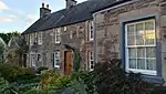 | |||
| The Cross, Cathedral Museum, Including Residential Properties To South Adjoining Burgh Chambers And Well To Rear | 56°11′21″N 3°57′51″W | Category A | 26372 |  | |||
| 58-62 (Even Nos) | 56°11′16″N 3°57′50″W | Category C(S) | 26397 | | |||
| High Street,St Blane's House, Including Gatepiers And Boundary Wall | 56°11′18″N 3°57′46″W | Category B | 26402 | | |||
| Perth Road, Anchorfield Including Boundary Wall | 56°11′37″N 3°57′26″W | Category B | 26408 | | |||
| Doune Road, Albert Cottage | 56°11′18″N 3°58′06″W | Category C(S) | 26423 | | |||
| Doune Road, 1 And 2 Calderwood Place | 56°11′18″N 3°58′06″W | Category C(S) | 26424 | | |||
| The Crescent, Elmswood Including Stables And Boundary Wall | 56°11′22″N 3°57′16″W | Category C(S) | 48944 | | |||
| Haining, Leighton House, (Front Elevation Only) | 56°11′24″N 3°57′53″W | Category C(S) | 48949 | | |||
| High Street, Dunblane Public Library | 56°11′20″N 3°57′44″W | Category C(S) | 48951 | | |||
| 50-56 (Even Nos) High Street | 56°11′16″N 3°57′50″W | Category C(S) | 48958 | | |||
| Perth Road, Crawford House Including Coach House | 56°11′20″N 3°57′32″W | Category C(S) | 48960 | | |||
| 91-95 (Odd Nos) High Street | 56°11′20″N 3°57′47″W | Category B | 26388 | | |||
| 114 High Street | 56°11′20″N 3°57′47″W | Category C(S) | 26392 | | |||
| Smithy Loan, Holmehill Lodge Including Gatepiers | 56°11′26″N 3°57′33″W | Category C(S) | 26406 | | |||
| Stirling Road, Bridge Of Dunblane | 56°11′11″N 3°57′51″W | Category C(S) | 26417 |  | |||
| 2 Bridgend And 9 Stirling Road | 56°11′10″N 3°57′54″W | Category B | 26418 |  | |||
| Stirling Road, Formerly The Railway Hotel | 56°11′10″N 3°57′53″W | Category C(S) | 26420 |  | |||
| The Cross, Dunblane Cathedral Halls | 56°11′21″N 3°57′54″W | Category B | 26364 | 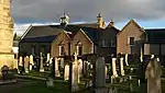 | |||
| Leewood Road, Ault Wharrie Including Summer House, Walled Garden, Terraced Garden Wall, Gate Lodge, Boundary Wall And Gatepiers | 56°11′08″N 3°56′52″W | Category A | 26365 | | |||
| Old Bleaching Green, Monument | 56°11′19″N 3°57′55″W | Category C(S) | 26367 | 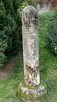 | |||
| Kirk Street And Sinclair Street, Scottish Churches House, South Terrace | 56°11′22″N 3°57′49″W | Category C(S) | 26375 | | |||
| Kirk Street, Scottish Churches House, Entrance House | 56°11′22″N 3°57′49″W | Category B | 26376 | 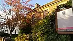 | |||
| 4 Sinclair Street | 56°11′21″N 3°57′48″W | Category C(S) | 26384 | | |||
| 108 And 112 High Street | 56°11′19″N 3°57′48″W | Category C(S) | 26391 | | |||
| 63 High Street, Bank House And Bank, Including Boundary Wall | 56°11′18″N 3°57′52″W | Category B | 26393 | | |||
| Smithy Loan, Woodend Including Boundary Wall | 56°11′19″N 3°57′39″W | Category C(S) | 26403 | | |||
| Perth Road, Burlington House Including Gatepiers And Boundary Wall | 56°11′19″N 3°57′33″W | Category C(S) | 26405 | | |||
| Glen Road, Tomdoran | 56°11′16″N 3°57′25″W | Category C(S) | 26410 | | |||
| Cathedral Square, Dunblane Cathedral (Cathedral Church Of St Blaan And St Laurence Including Churchyard, Boundary Wall And Riccarton's Stile) | 56°11′22″N 3°57′54″W | Category A | 26361 | 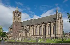 | |||
| Braeport, Aurora | 56°11′27″N 3°57′52″W | Category C(S) | 48941 | | |||
| The Haugh, War Memorial | 56°11′22″N 3°58′01″W | Category C(S) | 48950 | | |||
| 53 High Street | 56°11′17″N 3°57′52″W | Category C(S) | 48953 | | |||
| Newton Crescent, Provan Including Boundary Wall | 56°11′15″N 3°57′02″W | Category B | 49658 | | |||
| The Cross, Leighton Library | 56°11′19″N 3°57′52″W | Category A | 26371 | | |||
| Kirk Street, Scottish Churches House, North Terrace | 56°11′22″N 3°57′50″W | Category B | 26377 | | |||
| Kirk Street, Vaulted Chamber | 56°11′22″N 3°57′48″W | Category B | 26380 | 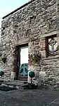 | |||
| 2 Sinclair Street | 56°11′21″N 3°57′48″W | Category C(S) | 26382 | | |||
| 5 Sinclair Street | 56°11′21″N 3°57′47″W | Category C(S) | 26385 | | |||
| High Street, Balhaldie House Including Gatepiers And Boundary Wall | 56°11′19″N 3°57′43″W | Category B | 26387 | | |||
| Perth Road, St Mary's Episcopal Church Including Gatepiers And Boundary Wall | 56°11′18″N 3°57′35″W | Category B | 26404 | | |||
| The Crescent, Glenacres Including Summer House | 56°11′13″N 3°57′19″W | Category B | 26411 | | |||
| Glen Road, Doocot Cottage, Dovecot | 56°11′06″N 3°57′18″W | Category B | 26413 | 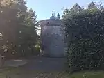 |
Key
The scheme for classifying buildings in Scotland is:
- Category A: "buildings of national or international importance, either architectural or historic; or fine, little-altered examples of some particular period, style or building type."[1]
- Category B: "buildings of regional or more than local importance; or major examples of some particular period, style or building type, which may have been altered."[1]
- Category C: "buildings of local importance; lesser examples of any period, style, or building type, as originally constructed or moderately altered; and simple traditional buildings which group well with other listed buildings."[1]
In March 2016 there were 47,288 listed buildings in Scotland. Of these, 8% were Category A, and 50% were Category B, with the remaining 42% being Category C.[2]
Notes
- Sometimes known as OSGB36, the grid reference (where provided) is based on the British national grid reference system used by the Ordnance Survey.
• "Guide to National Grid". Ordnance Survey. Retrieved 12 December 2007.
• "Get-a-map". Ordnance Survey. Retrieved 17 December 2007. - Historic Environment Scotland assign a unique alphanumeric identifier to each designated site in Scotland, for listed buildings this always begins with "LB", for example "LB12345".
References
- All entries, addresses and coordinates are based on data from Historic Scotland. This data falls under the Open Government Licence
- "What is Listing?". Historic Environment Scotland. Retrieved 29 May 2018.
- Scotland's Historic Environment Audit 2016 (PDF). Historic Environment Scotland and the Built Environment Forum Scotland. pp. 15–16. Retrieved 29 May 2018.
This article is issued from Wikipedia. The text is licensed under Creative Commons - Attribution - Sharealike. Additional terms may apply for the media files.