List of listed buildings in Drymen, Stirling
List
| Name | Location | Date Listed | Grid Ref. [note 1] | Geo-coordinates | Notes | LB Number [note 2] | Image |
|---|---|---|---|---|---|---|---|
| Buchanan Farmhouse And Attached Steading (Flats 1-5 Buchanan Home Farm), Including Pair Of Pavilion Blocks To North | 56°03′49″N 4°27′43″W | Category C(S) | 3898 |  | |||
| Drymen Bridge (Over Endrick Water) | 56°03′19″N 4°27′13″W | Category B | 3900 | | |||
| Drymen, 27 Main Street | 56°03′46″N 4°27′08″W | Category C(S) | 48980 | | |||
| Corrie Aqueduct Bridge (Former Glasgow Corporation Water Works) | 56°07′48″N 4°26′19″W | Category B | 51153 | | |||
| Finnich Malise, Entrance Lodge And Gateway | 56°02′21″N 4°26′16″W | Category C(S) | 6572 | | |||
| Gartinstarry, Including Boundary Wall To South East And Gartinstarry Cottage | 56°06′57″N 4°19′41″W | Category B | 3938 | | |||
| Drymen, Main Street, War Memorial | 56°03′54″N 4°27′08″W | Category C(S) | 48982 | | |||
| Auchentroig | 56°06′44″N 4°20′28″W | Category B | 48991 | | |||
| Dalnair House, Entrance Lodge And Gateway | 56°02′29″N 4°26′25″W | Category C(S) | 49001 | | |||
| Finnich Malise Wash House Over Burn To East Of Walled Garden | 56°02′10″N 4°26′22″W | Category C(S) | 6573 | | |||
| Ballochneck Bridge (Over Cashley Burn) | 56°07′04″N 4°18′11″W | Category B | 3939 | | |||
| Aucheneck House, Entrance Gateway | 56°01′23″N 4°24′51″W | Category C(S) | 48990 | | |||
| Dalnair House | 56°02′38″N 4°26′15″W | Category B | 49000 | 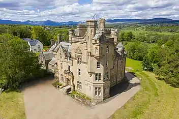 | |||
| Finnich Malise, Including Summer House To South | 56°02′13″N 4°26′34″W | Category B | 6570 | | |||
| Finnich Malise Steading And Stable Block | 56°02′11″N 4°26′40″W | Category B | 6571 | | |||
| Buchanan Castle, East Lodge And Entrance Gateway | 56°03′31″N 4°27′18″W | Category B | 3899 | 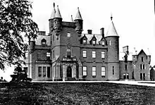 | |||
| Balfunning House, Former Stable Block (East And West Stables) | 56°04′31″N 4°23′47″W | Category C(S) | 48995 | | |||
| Ballochneck, Stables To South | 56°06′33″N 4°19′19″W | Category C(S) | 48998 | | |||
| To North Of Gartachoil, Milepost At Ns 5344 9349 | 56°06′42″N 4°21′31″W | Category C(S) | 49003 | | |||
| Drymen, 4 The Square | 56°03′58″N 4°27′10″W | Category C(S) | 49636 | | |||
| Hoish Aqueduct Overflow Or Outlet (Former Glasgow Corporation Water Works) | 56°06′15″N 4°22′49″W | Category C(S) | 51154 | | |||
| Dalnair Farmhouse | 56°02′37″N 4°25′03″W | Category B | 3907 | | |||
| Drymen, The Square, The Winnock | 56°03′57″N 4°27′11″W | Category B | 3912 | | |||
| Craigivairn, Including Adjacent Stone Built Farm Outbuildings | 56°05′17″N 4°25′27″W | Category B | 3913 | | |||
| Duchray Castle | 56°10′03″N 4°26′52″W | Category B | 3914 | | |||
| Strathendrick Golf Club, Pavilion | 56°03′26″N 4°27′03″W | Category C(S) | 48985 | | |||
| Balfunning House, East Lodge And Entrance Gateway | 56°04′25″N 4°23′11″W | Category C(S) | 48994 | | |||
| Castle Burn Aqueduct Bridge (Former Glasgow Corporation Water Works) | 56°09′28″N 4°27′52″W | Category A | 51152 | | |||
| Park Of Drumquhassle, Including Gatepiers To West | 56°03′04″N 4°26′16″W | Category C(S) | 3901 | | |||
| Auchentroig, Old Auchentroig | 56°06′44″N 4°20′32″W | Category A | 3937 | | |||
| Drymen, Stirling Road, Former United Secession Chapel (Drymen Church Hall) | 56°04′00″N 4°27′03″W | Category C(S) | 48983 | | |||
| Duchray Castle Lodge, Including Boundary Wall/ | 56°10′02″N 4°26′40″W | Category C(S) | 48984 | | |||
| Balfunning House, West Lodge And Entrance Gateway | 56°04′31″N 4°23′50″W | Category C(S) | 48996 | | |||
| Clachanry Farmhouse And Attached Wings | 56°04′07″N 4°23′29″W | Category C(S) | 48999 | | |||
| To East Of Garrauld, Milepost At Ns 5324 9192 | 56°05′51″N 4°21′39″W | Category C(S) | 49002 | | |||
| Finnich Malise, Walled Garden | 56°02′09″N 4°26′31″W | Category B | 6574 | | |||
| Park Of Drumquhassle, Sundial To South East Of House | 56°03′03″N 4°26′16″W | Category B | 3903 | | |||
| Chapelarroch Farm Bridge | 56°07′55″N 4°23′16″W | Category C(S) | 48875 | | |||
| Auchentroig, Walled Garden Adjoining Old Auchentroig To The South West | 56°06′43″N 4°20′34″W | Category C(S) | 48992 | | |||
| Balfunning House | 56°04′30″N 4°23′41″W | Category B | 48993 | | |||
| To South Of Kepculloch Toll, Milepost At Ns 5438 9189 | 56°05′51″N 4°20′33″W | Category C(S) | 49004 | | |||
| Park Of Drumquhassle, Dovecot To North | 56°03′10″N 4°26′13″W | Category B | 3902 | | |||
| Drymen, Main Street, Drymen Church (Church Of Scotland), Including Gatepiers And Boundary Wall | 56°03′40″N 4°27′10″W | Category B | 3911 | | |||
| Balmaha Road, Bridge Over Mill Burn | 56°04′04″N 4°27′25″W | Category C(S) | 48979 | | |||
| Drymen, Main Street, Former Drymen Manse (Endrick Hill) | 56°03′35″N 4°27′11″W | Category C(S) | 48981 | | |||
| Aucheneck House | 56°01′12″N 4°25′43″W | Category C(S) | 48989 | | |||
| Ballochneck | 56°06′35″N 4°19′18″W | Category B | 48997 | |
Key
The scheme for classifying buildings in Scotland is:
- Category A: "buildings of national or international importance, either architectural or historic; or fine, little-altered examples of some particular period, style or building type."[1]
- Category B: "buildings of regional or more than local importance; or major examples of some particular period, style or building type, which may have been altered."[1]
- Category C: "buildings of local importance; lesser examples of any period, style, or building type, as originally constructed or moderately altered; and simple traditional buildings which group well with other listed buildings."[1]
In March 2016 there were 47,288 listed buildings in Scotland. Of these, 8% were Category A, and 50% were Category B, with the remaining 42% being Category C.[2]
Notes
- Sometimes known as OSGB36, the grid reference (where provided) is based on the British national grid reference system used by the Ordnance Survey.
• "Guide to National Grid". Ordnance Survey. Retrieved 2007-12-12.
• "Get-a-map". Ordnance Survey. Retrieved 2007-12-17. - Historic Environment Scotland assign a unique alphanumeric identifier to each designated site in Scotland, for listed buildings this always begins with "LB", for example "LB12345".
References
- All entries, addresses and coordinates are based on data from Historic Scotland. This data falls under the Open Government Licence
- "What is Listing?". Historic Environment Scotland. Retrieved 29 May 2018.
- Scotland's Historic Environment Audit 2016 (PDF). Historic Environment Scotland and the Built Environment Forum Scotland. pp. 15–16. Retrieved 29 May 2018.
This article is issued from Wikipedia. The text is licensed under Creative Commons - Attribution - Sharealike. Additional terms may apply for the media files.