List of listed buildings in Callander, Stirling
List
| Name | Location | Date Listed | Grid Ref. [note 1] | Geo-coordinates | Notes | LB Number [note 2] | Image |
|---|---|---|---|---|---|---|---|
| Ancaster Square, Rob Roy And Trossachs Visitor Centre (Formerly St. Kessog's Church) | 56°14′39″N 4°12′52″W | Category B | 22885 |  | |||
| 15, 17 And 19 Main Street | 56°14′40″N 4°13′00″W | Category C(S) | 22893 | | |||
| Bridgend, Bridgend House Hotel | 56°14′33″N 4°13′04″W | Category C(S) | 22899 | 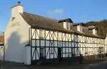 | |||
| Roman Camp Hotel Walled Garden | 56°14′24″N 4°12′29″W | Category C(S) | 22907 | | |||
| Loch Katrine, Portnellan, Macgregor Of Glengyle Burial Ground | 56°16′22″N 4°34′34″W | Category C(S) | 4066 | | |||
| Callandrade | 56°14′22″N 4°13′27″W | Category C(S) | 4014 | | |||
| Glengyle House Including Boundary Walls And Gatepiers | 56°17′09″N 4°36′33″W | Category B | 4024 | | |||
| Ancaster Road, Ach Na Coile Including Boundary Wall, Railings And Gatepiers | 56°14′45″N 4°12′50″W | Category C(S) | 50361 | | |||
| 10 Ancaster Square (Formerly Lesser St. Kessog's Church Hall) | 56°14′39″N 4°12′51″W | Category C(S) | 50365 | | |||
| 2, 4 And 6 Bridge Street Including Boundary Wall | 56°14′38″N 4°13′00″W | Category C(S) | 50382 | | |||
| Brig O'Turk, Trossachs Primary School And Schoolhouse | 56°13′55″N 4°22′01″W | Category C(S) | 50396 | | |||
| Kilmahog, Pass House | 56°14′58″N 4°15′27″W | Category C(S) | 50398 | | |||
| Milepost Near Coilantogle Nn 58958 06493 | 56°13′48″N 4°16′37″W | Category C(S) | 50401 | | |||
| 16, 18 And 20 Ancaster Square Including Outbuilding To 20 | 56°14′37″N 4°12′55″W | Category C(S) | 22889 | | |||
| 2 Bridgend, Teithview | 56°14′33″N 4°13′03″W | Category C(S) | 22898 | | |||
| 1, 2, 3, 4, 5, 6, 7, 8, 9, 10, 11 And 12 Esher Crescent, Scottish Veterans Garden Settlement Including War Memorial To Centre | 56°14′24″N 4°11′57″W | Category B | 22909 | | |||
| Leny House Walled Garden Including Outbuilding | 56°15′06″N 4°14′31″W | Category B | 3980 | | |||
| Kilmahog Bridge Over Garbh Uisge | 56°14′47″N 4°14′52″W | Category B | 4021 | | |||
| South Church Street, Sundial | 56°14′32″N 4°12′50″W | Category C(S) | 47152 | | |||
| Glengyle House Steading Including Cobbled Yard | 56°17′11″N 4°36′30″W | Category C(S) | 48701 | | |||
| Ancaster Square, War Memorial To South | 56°14′37″N 4°12′53″W | Category C(S) | 50362 | | |||
| Leny Feus, Callander Lodge Including Robertson House, Lodge And Stable, Boundary Walls, Gatepiers And Garden Features | 56°14′48″N 4°13′47″W | Category B | 50383 | | |||
| 24 Ancaster Square | 56°14′36″N 4°12′54″W | Category C(S) | 22891 | | |||
| Bridgend, Callander Primary School (Formerly Mclaren High School) | 56°14′31″N 4°12′59″W | Category C(S) | 22900 | | |||
| 182 Main Street, Roman Camp Gate House Including Boundary Wall, Rustic Arch And Gate | 56°14′31″N 4°12′30″W | Category C(S) | 22904 | | |||
| Loch Venachar Dam Including Sluice House, Weir And Fish Ladder (Former Glasgow Corporation Water Works) | 56°13′48″N 4°15′48″W | Category A | 4060 | 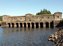 | |||
| Invertrossachs House Including Garden Shelter And Small Enclosed Garden, Tennis Pavilion And Kennels | 56°12′59″N 4°19′14″W | Category C(S) | 4061 | | |||
| Gart House Including Sunken Formal Garden And Boundary Wall To Nw | 56°13′57″N 4°11′39″W | Category C(S) | 4018 | | |||
| Glengyle, Macgregor Of Glengyle Burial Enclosure | 56°17′11″N 4°36′36″W | Category C(S) | 4023 | | |||
| 8 Ancaster Square | 56°14′38″N 4°12′51″W | Category C(S) | 50364 | | |||
| 24 Main Street, Kinnell House | 56°14′39″N 4°13′01″W | Category C(S) | 50385 | | |||
| 91 And 93 Main Street | 56°14′36″N 4°12′45″W | Category C(S) | 50389 | | |||
| Milepost At Nn 52832 06470 | 56°13′41″N 4°22′32″W | Category C(S) | 50534 | | |||
| Leny Road, St Andrew's Episcopal Church Including Hall, Boundary Wall, Railings, Gatepiers And Gates | 56°14′43″N 4°13′15″W | Category B | 22895 | | |||
| Brig O'Turk Trossachs Parish Church Including Graveyard, Boundary Walls, Gatepiers And Railings | 56°13′45″N 4°23′48″W | Category C(S) | 4064 | | |||
| Leny House Sundial | 56°15′06″N 4°14′35″W | Category B | 3981 | | |||
| Little Leny, Buchanan Burial Enclosure And Burial Ground At Confluence Of Eas Gobhain And Garbe Usige | 56°14′29″N 4°13′32″W | Category C(S) | 4015 | | |||
| Kilmahog, Woollen Mill | 56°14′47″N 4°14′34″W | Category C(S) | 4017 | | |||
| Kilmahog, Shieldaig | 56°14′47″N 4°14′28″W | Category C(S) | 4019 | | |||
| North Church Street, Sorisdale Cottage | 56°14′39″N 4°12′45″W | Category C(S) | 50392 | | |||
| Loch Katrine, Trossachs Pier | 56°14′03″N 4°25′48″W | Category C(S) | 50399 | | |||
| 1 Ancaster Square/57 Main Street | 56°14′38″N 4°12′54″W | Category C(S) | 22886 | | |||
| Callander Bridge Over River Teith | 56°14′35″N 4°13′02″W | Category B | 22897 | | |||
| 22 South Church Street, Waterside Cottage And South Church Street, Airlie Cottage Including Boundary Walls | 56°14′33″N 4°12′50″W | Category C(S) | 22903 | | |||
| Brig O'Turk | 56°13′44″N 4°22′17″W | Category B | 4062 | | |||
| Tigh Mor Trossachs (Former Trossachs Hotel) | 56°13′57″N 4°24′07″W | Category B | 4065 | | |||
| Ardchullarie More Including Lodge And Motor House/Kennel/ Byre | 56°17′36″N 4°17′17″W | Category B | 3983 | | |||
| Kilmahog Graveyard Including Mort House | 56°14′47″N 4°14′46″W | Category C(S) | 4020 | | |||
| Leny House Including Gatepiers And Sundial | 56°15′09″N 4°14′22″W | Category B | 4022 | | |||
| 38 Main Street (Formerly The Eagle Hotel) | 56°14′38″N 4°12′58″W | Category C(S) | 50386 | | |||
| South Church Street, Callander Kirk Hall (Former Free Church School) Including Low Boundary Wall And Piers | 56°14′34″N 4°12′46″W | Category C(S) | 50393 | | |||
| Anie Farmhouse | 56°15′47″N 4°16′51″W | Category C(S) | 50394 | | |||
| Bochastle Farm | 56°14′32″N 4°14′29″W | Category C(S) | 50395 | | |||
| Milepost Near Trossachs Parish Church Nn 51465 06750 | 56°13′48″N 4°23′51″W | Category C(S) | 50400 | | |||
| 3 Ancaster Square | 56°14′39″N 4°12′54″W | Category C(S) | 22887 | | |||
| 9 Ancaster Square (Formerly 5, 7 And 9) | 56°14′39″N 4°12′53″W | Category C(S) | 22888 | | |||
| Bridge Street, Callander Churchyard Including Watch House | 56°14′36″N 4°13′03″W | Category C(S) | 22896 | | |||
| 20 South Church Street, Waterside House | 56°14′33″N 4°12′50″W | Category B | 22902 | | |||
| 192 Main Street, Murdiston House Including Retaining Wall And Railing To N | 56°14′31″N 4°12′27″W | Category B | 22908 | | |||
| 4A And 8A Ancaster Square | 56°14′38″N 4°12′50″W | Category C(S) | 50363 | | |||
| 26 Ancaster Square | 56°14′36″N 4°12′54″W | Category C(S) | 50367 | | |||
| Leny Feus, Trean House | 56°14′49″N 4°13′51″W | Category B | 50384 | | |||
| 101 Main Street, The Crags Hotel | 56°14′35″N 4°12′43″W | Category C(S) | 50390 | | |||
| 5 Main Street, The Old Bank (Formerly National Commercial Bank) | 56°14′41″N 4°13′03″W | Category C(S) | 22894 | | |||
| Roman Camp Hotel Including Garden Features (Formerly Roman Camp House) | 56°14′26″N 4°12′34″W | Category B | 22906 | | |||
| Bridgend, Teithside House Including Low Boundary Wall And Gatepiers To West | 56°14′33″N 4°12′59″W | Category C(S) | 50376 | | |||
| Mansfield Including Dovecot, Raised Walkway, Gatepier To Ancaster Square And Boundary Walls | 56°14′36″N 4°12′58″W | Category C(S) | 22892 | | |||
| South Church Street, Callander Kirk (Formerly St. Bride's Church Of Scotland) | 56°14′34″N 4°12′46″W | Category B | 22901 | | |||
| Gartchonzie Bridge Over Eas Gobhain | 56°14′11″N 4°15′09″W | Category B | 3984 | | |||
| 11 Bridgend, Robertson House (Formerly Flowergrove) Including Gate, Gatepier And Boundary Walls To Nw, Sw | 56°14′31″N 4°13′01″W | Category C(S) | 50377 | | |||
| 170 Main Street Including Boundary Wall To Rear And Gatepiers | 56°14′32″N 4°12′32″W | Category C(S) | 50387 | | |||
| 35, 36, 37 And 39 Main Street Including 2, 4 And 6 Cross Street (Formerly Ancaster Arms Hotel) | 56°14′40″N 4°12′57″W | Category C(S) | 50388 | | |||
| Kilmahog, Bridgend Cottage | 56°14′47″N 4°14′55″W | Category C(S) | 50397 | | |||
| Milepost At Pass Of Trossachs Nn 50131 06829 | 56°13′49″N 4°25′09″W | Category C(S) | 50402 | |
Key
The scheme for classifying buildings in Scotland is:
- Category A: "buildings of national or international importance, either architectural or historic; or fine, little-altered examples of some particular period, style or building type."[1]
- Category B: "buildings of regional or more than local importance; or major examples of some particular period, style or building type, which may have been altered."[1]
- Category C: "buildings of local importance; lesser examples of any period, style, or building type, as originally constructed or moderately altered; and simple traditional buildings which group well with other listed buildings."[1]
In March 2016 there were 47,288 listed buildings in Scotland. Of these, 8% were Category A, and 50% were Category B, with the remaining 42% being Category C.[2]
Notes
- Sometimes known as OSGB36, the grid reference (where provided) is based on the British national grid reference system used by the Ordnance Survey.
• "Guide to National Grid". Ordnance Survey. Retrieved 12 December 2007.
• "Get-a-map". Ordnance Survey. Retrieved 17 December 2007. - Historic Environment Scotland assign a unique alphanumeric identifier to each designated site in Scotland, for listed buildings this always begins with "LB", for example "LB12345".
References
- All entries, addresses and coordinates are based on data from Historic Scotland. This data falls under the Open Government Licence
- "What is Listing?". Historic Environment Scotland. Retrieved 29 May 2018.
- Scotland's Historic Environment Audit 2016 (PDF). Historic Environment Scotland and the Built Environment Forum Scotland. pp. 15–16. Retrieved 29 May 2018.
This article is issued from Wikipedia. The text is licensed under Creative Commons - Attribution - Sharealike. Additional terms may apply for the media files.