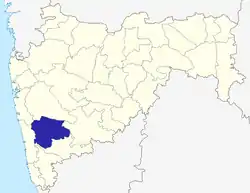
Mahabaleshwar
Mahabaleshwar (![]() pronunciation ) is a small town and a municipal council in Satara district in the Indian state of Maharashtra.It is a place of pilgrimage for Hindus because the Krishna river has its origins here.[1] The British colonial rulers developed the town as a hill station, and served as the summer capital of Bombay Presidency during the British Raj.
pronunciation ) is a small town and a municipal council in Satara district in the Indian state of Maharashtra.It is a place of pilgrimage for Hindus because the Krishna river has its origins here.[1] The British colonial rulers developed the town as a hill station, and served as the summer capital of Bombay Presidency during the British Raj.
Mahabaleshwar | |
|---|---|
 Mahabaleshwar  Mahabaleshwar | |
| Coordinates: 17.9307°N 73.6477°E | |
| Country | |
| State | Maharashtra |
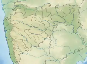
| District | Satara District |
| Area | |
| • Total | 137.15 km2 (52.95 sq mi) |
| Elevation | 1,353 m (4,439 ft) |
| Population (2011) | |
| • Total | 12,737 |
| • Density | 93/km2 (240/sq mi) |
| Languages | |
| • Official | Marathi |
| Time zone | UTC+5:30 (IST) |
| Sex ratio | 90 females/ 100 males ♀/♂ |
| Literacy Rate | 78% |
Geography
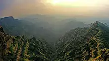
Mahabaleshwar is located on the mountainous Sahyadri range of the Western ghats that run North to south along western coast of India. The coordinates of the town are 17.9237°N 73.6586°E.[2] Mahabaleshwar is a vast plateau measuring 150 km2 (58 sq mi), bound by valleys on all sides. It reaches a height of 1,439 m (4,721 ft) at its highest peak above sea level, known as Wilson/Sunrise Point The town is about 120 km (75 mi) southwest of Pune and 285 km (177 mi) from Mumbai, .
Mahabaleshwar comprises three villages: Malcolm Peth, Old "Kshetra" Mahabaleshwar and part of the Shindola village.
Mahabaleshwar region is the source of the Krishna River that flows across Maharashtra, Karnataka, Telangana and Andhra Pradesh. The legendary source of the river is a spout from the mouth of a statue of a cow in the ancient temple of Mahadev in Old Mahabaleshwar. Legend has it that Krishna is Lord Vishnu himself as a result of a curse on the trimurtis by Savitri. Also, its tributaries Venna and Koyna are said to be Lord Shiva and Lord Brahma themselves. An interesting thing to notice is that 3 other rivers come out from the cow's mouth apart from Krishna and they all travel some distance before merging into Krishna which flows East towards the Bay of Bengal. These rivers are the Koyna, Venna (Veni) and Gayatri. The Savitri river flows Westward via Mahad to the Arabian Sea.
Climate of the area is suitable for cultivation of strawberries, Mahabaleshwar strawberry contributes to about 85 percent of the total strawberry production in the country.[3][4][5][6] It also received the geographical indication (GI) tag in 2010.[7]
Climate
Very heavy rainfall is a normal occurrence during monsoons. During July, 10–12 days of continuous rains with 100–200 mm rains each day can be seen each year.
| Climate data for Mahabaleshwar (1981–2010, extremes 1932–2011) | |||||||||||||
|---|---|---|---|---|---|---|---|---|---|---|---|---|---|
| Month | Jan | Feb | Mar | Apr | May | Jun | Jul | Aug | Sep | Oct | Nov | Dec | Year |
| Record high °C (°F) | 32.4 (90.3) |
33.9 (93.0) |
38.2 (100.8) |
37.6 (99.7) |
37.4 (99.3) |
34.8 (94.6) |
31.7 (89.1) |
29.6 (85.3) |
29.2 (84.6) |
31.9 (89.4) |
30.8 (87.4) |
31.0 (87.8) |
38.2 (100.8) |
| Average high °C (°F) | 26.3 (79.3) |
27.9 (82.2) |
30.7 (87.3) |
31.8 (89.2) |
30.1 (86.2) |
23.2 (73.8) |
19.9 (67.8) |
19.5 (67.1) |
21.9 (71.4) |
25.6 (78.1) |
25.6 (78.1) |
25.5 (77.9) |
25.7 (78.3) |
| Average low °C (°F) | 13.4 (56.1) |
14.4 (57.9) |
17.1 (62.8) |
18.6 (65.5) |
18.1 (64.6) |
17.3 (63.1) |
16.9 (62.4) |
16.6 (61.9) |
16.1 (61.0) |
16.0 (60.8) |
14.6 (58.3) |
13.5 (56.3) |
16.1 (61.0) |
| Record low °C (°F) | 5.6 (42.1) |
3.9 (39.0) |
7.7 (45.9) |
11.1 (52.0) |
12.5 (54.5) |
12.0 (53.6) |
12.2 (54.0) |
11.3 (52.3) |
10.5 (50.9) |
10.0 (50.0) |
7.4 (45.3) |
6.4 (43.5) |
3.9 (39.0) |
| Average rainfall mm (inches) | 1.0 (0.04) |
0.3 (0.01) |
6.1 (0.24) |
21.5 (0.85) |
47.6 (1.87) |
977.7 (38.49) |
2,064.4 (81.28) |
1,784.3 (70.25) |
537.1 (21.15) |
140.1 (5.52) |
32.3 (1.27) |
8.0 (0.31) |
5,620.3 (221.27) |
| Average rainy days | 0.1 | 0.1 | 0.4 | 1.3 | 3.7 | 20.5 | 29.6 | 29.2 | 19.5 | 7.2 | 2.2 | 0.4 | 114.3 |
| Average relative humidity (%) (at 17:30 IST) | 49 | 39 | 41 | 51 | 67 | 92 | 98 | 98 | 94 | 76 | 64 | 56 | 69 |
| Source 1: India Meteorological Department[8][9] | |||||||||||||
| Source 2: Government of Maharashtra[10] | |||||||||||||
History
The first historical mention of Mahabaleshwar dates back to year 1215 when the King Singhan of Deogiri visited Old Mahabaleshwar. He built a small temple and water tank at the source of the river Krishna. Around 1350, a Brahmin dynasty ruled this area. In the middle of the 16th century the Maratha family of Chandarao More defeated the Brahmin dynasty and became rulers of Javli and Mahabaleshwar, during which period Old Mahabaleshwar temple was rebuilt.
In 1656, the founder of Maratha empire, Shivaji on account of political circumstances, killed Chandrarao More, a fellow Maratha feudatory of Bijapur, and seized the valley of Javali, near Mahabaleshwar,from him.[11][12] Around that time Chhatrapati Shivaji Maharaj also built a fort near Mahabaleshwar called Pratapgad.The fort remains in the hands of Shivaji's descendants to this day.
British colonial era

In 1819, after the demise of the Maratha empire, the victorious British ceded the hills around Mahabaleshwar to the vassal state of Satara. Colonel Lodwick (Later General Sir Lodwick) after climbing the mountains near Mahabaleshwar, recommended the place as a sanatorium for the British forces to governor Sir John Malcolm of Bombay presidency. The Raja of Satara was granted other villages in exchange for the British getting Mahabaleshwar in 1828.[13] In old records Mahabaleshwar was even called as Malcolm Peth after the governor.[14] Mahabaleshwar started gaining prominence when British officials of Bombay presidency such as in 1828, and later Sir Mountstuart Elphinstone, Arthur Malet (for whom the seat at "Point Arthur" is named), Carnac, and many others became regular visitors. A lake called Venna lake was constructed in 1842 to collect water from perennial springs.The Venna river flows from this lake.[15] Bartley Frere, the commissioner of Satara in 1850s built the road from Satara to Mahabaleshwar.[16] In mid 1800s, Mahabaleshwar was made into summer capital of Bombay presidency.[17] Government spending led to rapid development of the area.Colonial officials spent part of their year in the area.Their wives spent longer period to be with their children in local boarding schools in Mahabaleshwar and nearby Panchgani.[18][19] The British rulers wanted to recreate the English landscape in the hill stations and to that end, European flora such as strawberries[20] were introduced in Mahabaleshwar, and amenities such as libraries,theatres, boating lakes, and sports grounds constructed. [21]
Added to the scores of magnificent scenic "points", the perennial springs, streams, and waterfalls of Mahabaleshwar plateau, with its year round superb climate, drew the English and others to Mahabaleshwar. By the end of the 19th century it had become an attractive popular hill station of world renown. Raj Bhavan, the Summer residence of the Governor of Maharashtra, is also located here. An older building named "The Terraces" was purchased in 1884 and rechristened as Giri Darshan in 1886.[22]
"Babington House", is a colonial-style bungalow built in the shape of a cross with a deep veranda, elaborate metal work railing and extensive outhouses. It was formerly one of the country seats of the Dubash family, a Parsi ship chandler dynasty from Bombay who sold it to the Rahejas in the early 1970s. It contains a central dining room with a 24-seater table and a library pavilion with 1st edition books collected by the Dubash family, notably Jamsetjee "Jimmy" Kavasjee Dubash, a bibliophile and art collector.
Places of interest
Old Mahabaleshwar
.jpg.webp)
In old Mahabaleshwar, 7 km from Mahabaleshwar, there are many tourist points and 5 temples to see, with examples of old Indian architecture. There are also natural view points, some of them named by the 19th-century British colonial rulers.
Krishnabai temple
Behind Panchganga temple, there is a small trail that leads to Krishnabai temple where the Krishna river is worshiped. It is built on the hilltop overlooking the Krishna valley and was built in 1888 by a ruler of Ratnagiri on the Konkancoast. The temple has a Shiva lingam and a beautiful statue of Krishna. A small stream of the river flowing from a cow-face (gomukh) falls on a 'Kunda' or water tank. Stone carved columns and ceilings are the special characteristics of this temple. This old temple has gathered moss and is in ruins. It is not visited much by tourists and is isolated. But it provides a most exquisite view of the river Krishna.
3 Monkey Point
Named because of the natural sculpture of the stones which looks like three monkeys sitting beside each other and portraying 3 monkeys of Gandhiji. Nestled deep in the valleys one can figure out from the outline of a big stone a natural cut out it give an effect of 3 monkey sitting next to each other portraying the Three Wise Monkeys. This point is on route to Arthur's Seat.
Arthur point
This geographical point is named after Officer Sir Arthur Malet (1806–1888) (not to be confused with British born actor of same name), who frequented the spot to gaze at the Savitri River, where he lost his wife and children in a tragic ferry mishap.
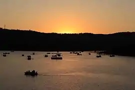
Venna Lake
Mahabaleshwar is a holiday resort, honeymoon spot, and a pilgrimage site for People.
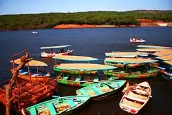
The Venna lake is one of the tourist attractions of Mahabaleshwar. The lake is surrounded by trees.
There are hotels from budget hotels to 3 Stars hotels. There are hotels with the Lake's View or in the market.[23]
Kate's Point
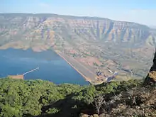
Kate's point is located to the east of Mahabaleshwar and is famous for its view of two reservoirs, Balakwadi and Dhom. The point is around 1,280 m high.
Needle Hole Point / Elephant Point
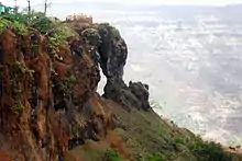
Needle hole point is located near Kate's Point. One can see a natural rock formation with a hole in between, thus giving the name Needle-hole. The point is also famous for the view of Deccan traps, which look like an elephant's trunk.
Wilson Point
Named after Sir Leslie Wilson, the Governor of Bombay from 1923 to 1926, Wilson Point is the highest point in Mahabaleshwar at 1439 m. Known as Sindola Hill during the colonial rule, Wilson point is the only location in Mahabaleshwar where both sunrise and sunset can be seen. It offers a spectacular glance of Mahabaleshwar in all directions. It located at behind Mahabaleshwar-Medha road at 1.5 km from Mahabaleshwar city.
Pratapgad
Pratapgad is a fort near Mahabaleshwar built by Chatrapati Shivaji Maharaj. It is the site of the encounter between Shivaji and Bijapur general, Afzalkhan, where the latter was defeated and killed by Shivaji Maharaj.
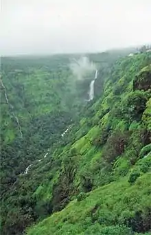
Lingmala Waterfalls
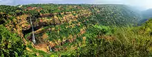
This waterfalls is located near Mahabaleshwar. The water here falls from a height of approximately 600 feet. The water of Lingamala waterfalls cascades into the Venna Lake. The waterfalls are divided by outward projecting rocks into multiple tiers.
Demographics
As of 2011 India census,[24] Mahabaleshwar had a population of 12,737. Males constituted 55% of the population and females 45%. Mahabaleshwar had an average literacy rate of 78%, higher than the national average of 74.04%: male literacy was 84%, and female literacy was 71%. In Mahabaleshwar, 11% of the population was at that time under 6 years of age.
Transport
Road
Mahabaleshwar is 32 km from Wai. It is 260 km from Mumbai, the state capital. The nearest major city is Satara, 45 km and it is 120 km from Pune and 263 km from Mumbai thane Mahabaleshwar is connected by the National Highway 4. Bus services by state-run MSRTC and private organizations connect it to Pune, Mumbai, Sangli and Satara.
Rail
Nearest railroad is Satara, 60 km. Nearby major railway junctions include Pune (120 km), and Miraj (170 km) . State-run bus services are available in these locations to Mahabaleshwar. Rail station Diwan Khavati on Kokan Railway near Khed gives a route of 60 km via Poladpur to Mahabaleshwar.
Air
The nearest airport is Pune International Airport, serving the city of Pune, 120 km from Mahabaleshwar. Chhatrapati Shivaji International Airport of Mumbai is 270 km.
Gallery

.jpg.webp)
References
- Ian Talbot (2016). A History of Modern South Asia: Politics, States, Diasporas. Yale University Press. p. 36. ISBN 978-0-300-19694-8.
- "Falling Rain Genomics, Mahabaleshwar".
- Kasabe, Nanda (18 February 2012). "Growing demand for strawberries in domestic market". The Financial Express. Retrieved 1 February 2016.
- Kshirsagar, Alka (16 January 2012). "Mahabaleshwar set for good strawberry season". The Hindu Business Line. Retrieved 27 January 2016.
- Mahableshwar-where strawberries grow:https://www.outlookindia.com/newsscroll/mahabaleshwar--where-strawberries-grow/1757666
- Strawberry fields forever:https://punemirror.indiatimes.com/entertainment/unwind/strawberry-fields-forever/articleshow/74419558.cms
- Joshi, Hrishikesh (14 May 2010). "Mahabaleshwar strawberry gets GI status". Business Standard. Retrieved 27 January 2016.
- "Station: Mahabaleshwar Climatological Table 1981–2010" (PDF). Climatological Normals 1981–2010. India Meteorological Department. January 2015. pp. 457–458. Archived from the original (PDF) on 5 February 2020. Retrieved 9 April 2020.
- "Extremes of Temperature & Rainfall for Indian Stations (Up to 2012)" (PDF). India Meteorological Department. December 2016. p. M145. Archived from the original (PDF) on 5 February 2020. Retrieved 9 April 2020.
- "Climate". Government of Maharashtra. Retrieved 9 April 2020.
- Farooqui, A Comprehensive History of Medieval India 2011, p. 317.
- Chakrabarty, Dipesh (2015). The Calling of History: Sir Jadunath Sarkar and His Empire of Truth. University of Chicago Press. p. 147. ISBN 978-0-226-24024-4.
- Sumitra Kulkarni (1995). The Satara Raj, 1818-1848: A Study in History, Administration, and Culture. Mittal Publications. pp. 174–177. ISBN 978-81-7099-581-4.
- Dane Keith Kennedy (1 January 1996). The Magic Mountains: Hill Stations and the British Raj. University of California Press. p. 24. ISBN 978-0-520-20188-0.
- Puri, G.S. and Mahajan, S.D., 1960. The study of the evergreen vegetation of Mahabaleshwar area. Nelumbo, 2(1-2), pp.109-137.
- Rekha Ranade (1990). Sir Bartle Frere and His Times: A Study of His Bombay Years, 1862-1867. Mittal Publications. pp. 9–. ISBN 978-81-7099-222-6.
- Lionel Knight (2012). Britain in India, 1858-1947. Anthem Press. p. 15. ISBN 978-0-85728-517-1.
- Baker, K., 2009. The changing tourist gaze in India’s hill stations: from the early nineteenth century to the present. Environment, Politics and Development Working Paper Series. London: Department of Geography, King’s College. Available online: http://www. kcl. ac. uk/schools/sspp/geography/research/epd/working. html.
- Peter M. Burns; Cathy Palmer; Jo-Anne Lester; Kathleen Baker (2010). Tourism and Visual Culture Theories and concepts. CABI. pp. 2, 5, 11. ISBN 978-1-84593-609-9.
- Mahabaleshwar strawberry gets GI status | Business Standard News
- Mariam Dossal; Ruby Maloni (1999). State Intervention and Popular Response: Western India in the Nineteenth Century. Popular Prakashan. pp. 32–34. ISBN 978-81-7154-855-2.
- "The History of Raj Bhavan, Mumbai". Retrieved 8 February 2016.
- "Airsky Mahabaleshwar". Archived from the original on 10 December 2013. Retrieved 5 January 2014.
- "Census of India 2001: Data from the 2001 Census, including cities, villages and towns (Provisional)". Census Commission of India. Archived from the original on 16 June 2004. Retrieved 1 November 2008.
External links
| Wikimedia Commons has media related to Mahabaleshwar. |
| Wikivoyage has a travel guide for Mahabaleshwar. |
- The other Mahabaleshwar by Dhruti Vaidya Design Studio
- Mahabaleshwar page of Maharashtra Tourism website
Satara district topics | ||
|---|---|---|
| History |
|  |
| Battles | ||
| Rivers | ||
| Dams | ||
| Lakes |
| |
| Ghats | ||
| Caves | ||
| Cities and towns | ||
| Villages | ||
| Places to see | ||
| Monuments | ||
| Transport | ||
| Education | ||
| Lok Sabha constituencies | ||
| Vidhan Sabha constituencies | ||
| Culture | ||