Jog Falls
Jog Falls, is a waterfall on the Sharavati river[4] located in the Western Ghats Sagara taluk, Shimoga district.[5][6] It is the second highest plunge waterfall in India.[7][8] It is a segmented waterfall which depends on rain and season becomes a plunge waterfall. The falls are major attractions for tourists and is ranked 13th in the world by the waterfall database.[9]
| Jog Falls | |
|---|---|
| Joga Jalapatha Jogada gundi | |
 | |
| Type | Cataract, segmented |
| Elevation | 488 m (1,601 ft) |
| Total height | 253 m (830 ft) [1] |
| Number of drops | 4
(Raja, Rani, Roarer, Rocket) [2] |
| Longest drop | 254 m (833 ft) |
| Average width | 472 m (1,549 ft) |
| Watercourse | Sharavati River [3] |
| Average flow rate | 153 m3/s (5,400 cu ft/s) |
Description
Jog Falls is created by the Sharavati dropping 253 m (830 ft), making it the third-highest waterfall in India after the Nohkalikai Falls with a drop of 335 m (1,099 ft) in Meghalaya [10] and Dudhsagar Waterfalls with a drop of 310 m (1,020 ft) in Goa.
Sharavathi, a river which rises at Ambutirtha, next to Nonabur, in the Thirthahalli taluk and takes the northwesterly course by Fatte petta, receives the Haridravati on the right below Pattaguppe and the Yenne Hole on the left above Barangi. On arriving at the frontier it bends to the west, precipitates itself down the Falls of Gersoppa, and passes that village (properly Geru-Sappe), which is some 30 kilometres (19 mi) distant, discharging into the Arabian sea at Honnavar in Uttara Kannada.
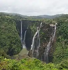
The Sharavati, flowing over a very rocky bed about 250 yards (230 m) wide, here reaches a tremendous chasm, 290 m (950 ft) deep, and the water comes down in four distinct falls. The Raja Fall pours in one unbroken column sheer to the depth of 250 m (830 ft). Halfway down it is encountered by the Roarer, another fall, which precipitates itself into a vast cup and then rushes violently downwards at an angle of forty-five degrees to meet the Raja. A third fall, the Rocket, shoots downwards in a series of jets; while the fourth, the Rani, moves quietly over the mountainside in a sheet of foam. The Tourism Department has built steps from the viewpoint to the bottom of the hill where the waterfall can be seen at the opposite side. There are approximately 1400 steps built to reach the bottom of the hill.[11]
Significance
Associated with the waterfall is the nearby Linganamakki Dam across the Sharavati River.[12] The power station has been operational since 1948 and is of 120 MW capacity, one of the largest hydroelectric stations in India at that time and a small source of electric power for Karnataka now. The power station was previously named Krishna Rajendra hydro-electric project, after the King of Mysore at that time. The name was later changed to Mahatma Gandhi Hydro-electric Project. It was served by The Hirebhaskara dam until 1960. After 1960, due to the ideas of Mokshagundam Visvesvarayya, Linganmakki Dam has been used for power generation.
Power
The hydro-electric project was conceived by the government of Mysore in mid-1943. A scheme to generate 64,000 horsepower at a cost of ₹358 lakh was designed.[13] The capacity was increased subsequently and currently generates 6.7 MW of power.
Transport connectivity
Jog Falls is situated on the borders of Shimoga and North Kanara, 100 km (62 mi) from Shimoga city. The Western Ghats gives rise to the Sharavati river that plunges from a height of 829 feet (253 m) in four magnificent cascades namely Raja, Rani, Roarer and Rocket. Jog falls, being the tallest waterfalls in India is situated in the dense evergreen forests, 16 km (9.9 mi) from Talguppa nearest railway station, Shimoga district, Karnataka.
- Nearest railway station (distance to the location):
- Nearest bus station: Sagara, and Jogfalls bus stop. Nearest centre for private road transport is Sagara.
- Nearest airport (aerial distance to the location):
- Domestic
- Hubli Airport (HBX): 130 km (81 mi)
- International
- Bengaluru International Airport (BLR): 422 km (262 mi)
- Mangalore International Airport (India) (formerly Bajpe Airport) (IXE): 200 km (120 mi)
- Goa Airport (GOI): 264 km (164 mi)
- Domestic
Gallery
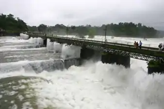 Canal Gates near Jog Falls
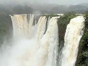 Jog Roarer
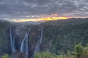 Early Morning at Jog Falls
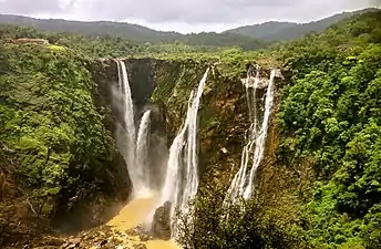 Jog Falls in late monsoon
References
- "Jogfalls Height". Jog Falls Official website.
- "Jog Falls". Jogfalls official website.
- "Jogfalls". Jog Falls Official website.
- "River". Jogfalls official website.
- "Jog Falls Location". Jogfalls official website.
- "Jog falls Location". Shivamogga NIC.
- Top 10 Highest Waterfalls in India
- Monsoon magic: Jog Falls, nature lovers' delight TRAVEL, IBN news channel, 10 August 2008
- Jog Falls World Waterfall Database: World's Tallest Waterfalls
- Gopal, Madan (1990). K.S. Gautam (ed.). India through the ages. Publication Division, Ministry of Information and Broadcasting, Government of India. p. 179.
- "Jog Falls: the jewel of Sharavathi Valley". JLR Explore. Retrieved 28 August 2020.
- Karnataka Power Corporation Article Archived 19 January 2009 at the Wayback Machine
- "Jog Falls Hydro-Electric Project". The Indian Express. 2 July 1943. p. 4. Retrieved 12 April 2017.
External links
| Wikimedia Commons has media related to Jog Falls. |
| Wikisource has original text related to this article: |
- Jog Falls on jogfalls.in. Jog Management Authority. Retrieved 16 November 2018.
- Jog Falls on Karnataka Government official Website