Satara (city)
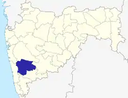
Satara (![]() pronunciation ) (ISO: Sātārā) is a city located in the Satara District of Maharashtra state of India, near the confluence of the river Krishna and its tributary, the Venna.[1] The city was established in the 16th century and was the seat of the Chhatrapati of Maratha Empire, Shahu I. It is the headquarters of Satara Tehsil, as well as the Satara District. The city gets its name from the seven forts (Sat-Tara) which are around the city. The city is known as a Soldier's city as well as Pensioner's city.
pronunciation ) (ISO: Sātārā) is a city located in the Satara District of Maharashtra state of India, near the confluence of the river Krishna and its tributary, the Venna.[1] The city was established in the 16th century and was the seat of the Chhatrapati of Maratha Empire, Shahu I. It is the headquarters of Satara Tehsil, as well as the Satara District. The city gets its name from the seven forts (Sat-Tara) which are around the city. The city is known as a Soldier's city as well as Pensioner's city.
Satara
Shahunagari | |
|---|---|
City | |
 Satara Location of Satara in Maharashtra | |
| Coordinates: 17.688°N 74.006°E | |
| Country | |
| State | Maharashtra |
| District | Satara |
| Established | 16th century |
| Founded by | Shahu I |
| Named for | 'Saat Tara' or Saat Tare meaning Seven Stars denoting the seven hill forts in the adjoining areas of the city |
| Government | |
| • Body | Municipality of Satara |
| Area | |
| • Total | 22.42 km2 (8.66 sq mi) |
| Elevation | 742 m (2,434 ft) |
| Population (2011) | |
| • Total | 326,079 |
| Demonym(s) | Satarkar |
| Language | |
| • Official | Marathi |
| Time zone | UTC+5:30 (IST) |
| PIN | 415001, 415002, 415003, 415004, 415005, 415006 |
| Telephone code | 02162 |
| Vehicle registration | MH-11 |
| Website | www |
History
The first Muslim invasion of the Deccan took place in 1296. In 1636 the Nizam Shahi dynasty came to an end. In 1663 Chhatrapati Shivaji Maharaj conquered Parali and Satara fort. After the death of Chhatrapati Shivaji Maharaj, Shahu Shivaji, heir apparent to the Maratha Empire, captured by Mughals when he was only seven years old, remained their prisoner till the death of his father in 1700. The Dowager Maharani Tarabai proclaimed his younger half-brother, and her son, Shahu Sambhaji as Chhatrapati Maharaj under her regency. Mughals released Shahu under certain preconditions in 1707, so that Marathas would face an internal war for the throne. Shahu returned to the Maratha Empire and claimed his inheritance. Aurangzeb's son Muhammad Azam Shah conquered Satara fort Ajinkyatara after a 6-month siege, later won by Parshuram Pratinidhi in 1706. In 1708 Chattrapati Shahu, the son of Sambhaji, was crowned at the Satara fort. The direct descendants of Raja Shivaji continue to live in Satara. Udayanraje Bhonsle is the 13th descendant of Shivaji Maharaj.[2]
Geography
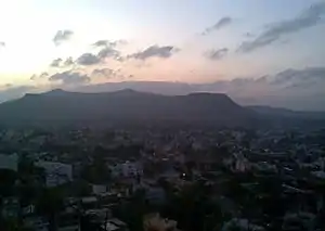
Satara is located at 17.68°N 73.98°E.[3] It lies in the Satara District.[4] Satara city is surrounded by seven mountains. Satara lies on the slope of Ajinkyatara fort.[5] It lies on the western side of the Deccan Plateau. Pune and Solapur are the main cities close to Satara.[6] The city is surrounded by the tehsils of Koregaon on the West, Karad and Patan on the South, Jawali on the East and Wai on the North.[7]
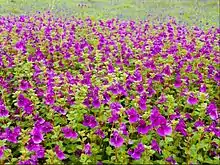
National Highway 48 (formerly National Highway 4) passes through Satara, between Karad and Khandala.[8] Kaas Plateau, a valley of flowers, is situated 25 kms away from Satara .[9]
The Satara District experiences earthquakes of minor magnitudes. the epicenter of these earthquakes are scattered in Phaltan district.[10]
Satara is famous for Kaas Plateau, Thoseghar, and a lot of natural sites present in the vicinity of the city. Kass Plateau has been awarded as a UNESCO's World Heritage Site (WHS). In the monsoon months, the Kaas Pathar, as it is locally known, transforms into a wildflower wonderland. More particularly so in September when vivid shades of pink balsams, yellow smithias, and blue utricularias carpet the vast grasslands. It’s a must-visit for serious botanists, amateur photographers to witness the spectrum of Western Ghats monsoon montane grasslands flora, some of which are rare and endangered. [11]
Climate
Satara city has a pleasant climate all year round due to mountains surrounding the city. Summers are not too hot and winters are not too cold. Satara city receives moderate rainfall around 1,200 to 1,500 mm all year round.
| Climate data for Satara (1981–2010, extremes 1933–2012) | |||||||||||||
|---|---|---|---|---|---|---|---|---|---|---|---|---|---|
| Month | Jan | Feb | Mar | Apr | May | Jun | Jul | Aug | Sep | Oct | Nov | Dec | Year |
| Record high °C (°F) | 35.8 (96.4) |
38.0 (100.4) |
40.5 (104.9) |
41.9 (107.4) |
42.1 (107.8) |
40.9 (105.6) |
33.5 (92.3) |
35.2 (95.4) |
34.6 (94.3) |
37.7 (99.9) |
36.0 (96.8) |
34.0 (93.2) |
42.1 (107.8) |
| Average high °C (°F) | 29.8 (85.6) |
32.4 (90.3) |
35.4 (95.7) |
37.2 (99.0) |
36.6 (97.9) |
30.4 (86.7) |
27.0 (80.6) |
26.5 (79.7) |
28.9 (84.0) |
30.9 (87.6) |
30.1 (86.2) |
29.3 (84.7) |
31.2 (88.2) |
| Average low °C (°F) | 12.8 (55.0) |
14.2 (57.6) |
18.1 (64.6) |
21.1 (70.0) |
22.7 (72.9) |
22.5 (72.5) |
21.8 (71.2) |
21.2 (70.2) |
20.5 (68.9) |
19.2 (66.6) |
15.9 (60.6) |
13.3 (55.9) |
18.6 (65.5) |
| Record low °C (°F) | 4.8 (40.6) |
5.8 (42.4) |
9.1 (48.4) |
12.3 (54.1) |
15.2 (59.4) |
18.0 (64.4) |
19.0 (66.2) |
14.5 (58.1) |
14.5 (58.1) |
13.2 (55.8) |
9.0 (48.2) |
7.3 (45.1) |
4.8 (40.6) |
| Average rainfall mm (inches) | 1.1 (0.04) |
0.2 (0.01) |
5.1 (0.20) |
20.2 (0.80) |
27.2 (1.07) |
199.7 (7.86) |
224.9 (8.85) |
172.1 (6.78) |
124.1 (4.89) |
100.6 (3.96) |
21.6 (0.85) |
8.7 (0.34) |
905.3 (35.64) |
| Average rainy days | 0.1 | 0.1 | 0.3 | 1.4 | 2.1 | 10.9 | 15.3 | 12.8 | 8.1 | 5.5 | 1.5 | 0.4 | 58.7 |
| Average relative humidity (%) (at 17:30 IST) | 36 | 29 | 28 | 34 | 44 | 70 | 78 | 79 | 71 | 56 | 47 | 41 | 51 |
| Source 1: India Meteorological Department[12][13] | |||||||||||||
| Source 2: Government of Maharashtra[14] | |||||||||||||
Demographics
As of 2011 India census,[15] Satara had a population of 120,079; 61,129 are males while 59,066 are females, thus males constituted 52% of the population and females 48%.[16] Satara has an average literacy rate of 80%, higher than the national average of 74%: male literacy is 84%, and female literacy is 76%. In Satara, 10% of the population is under 6 years of age. Marathi is the native and most widely spoken language.
Maharashtra state's sex ratio is 883 girls per 1000 boys, and Satara fares worse still at 881, in spite of the high level of literacy.[17]
The population of Satara has crossed the municipal limits and actual urban agglomerate population 326,765. The city is surrounded with census towns viz. Pratikash B. Karanje, Khed, Godoli and Vilaspur. These census towns are considered as suburban of Satara city.
The nod for Satara city limit expansion was given by Mr. Devendra Phadanvis then chief minister of Maharashtra on 16 September 2019. The matter was pending for 40 years. The borders of city will be extended upto NH4 towards east, upto Anjikyatara towards south, all region south to Venna river. Shahupuri, Sambhajinagar, Vilaspur and Dare Budruk grampanchayats will become a part of Satara city.
Government and politics
Satara city falls under Satara Lok Sabha constituency, represented by MP Shriniwas Patil from the Nationalist Congress Party.[18] The city also elects an MLA from the Satara Vidhan Sabha constituency, represented by BJP's Shivendrasinh Abhayasinh Bhosale.[19] [20]
Civic Administration
Satara is a Municipal Council city in district of Satara, Maharashtra.[21] Satara Municipal Council, with population of about 1.2 lakh is Satara sub district's only municipal council located in Satara sub district of Satara district in the state Maharashtra in India.[22] Total geographical area of Satara municipal council is 8 square km. Population density of the city is 14748 persons per square km. [23]
The Satara city is divided into 39 wards for which elections are held every 5 years.[24] Among them Satara Ward No 19 is the most populous ward with population of 4691 and Satara Ward No 23 is the least populous ward with population of 2206.[25]
Civic utilities
Water from the Kaas lake is supplied to Satara city for drinking purposes.[26] Maharashtra Jeevan Pradhikaran supplies water to Satara city.[27] 19 MLD is supplied , but because of water leakage during transmission, only 17.2 MLD gets supplied effectively.[28]
Satara Municipal Council is responsible for providing sanitation and solid waste management services in the city, through private contractors.[28] 70 MT/day of solid waste is generated per day. 18 Mt/ day is disposed off through composting.[29] 8.17 sq kms of the city, covering 20972 households, are covered under door to door collection.[30]
12.8 MLD of sewage is generated in the city.[29] Satara Municipal Council has plans to construct a STP of 17.5 MLD capacity.[29]
The Maharashtra Right to Public Service Act, 2015 is a revolutionary Act.[31] Citizens can get complete information regarding which services are available under this Act by accessing either the mobile app RTS Maharashtra or ‘Aaple Sarkar’ Web Portal.[32] Citizens can even apply online for availing these services. [33]
Economy
Sugarcane is the single biggest crop of Satara along with turmeric and ginger. The Satara district has around 302 banks. The per capita of Satara district is nearly 1.2 times the state average.[34] The British had, during the pre-Independence period started a variety of industries in Satara for Menthol and soap manufacturing in 1905. Bigger industries for copper were started in 1922. After independence, the whole district was stagnant in industrial growth. From 1950-60, industrial growth restarted and the manufacture of jaggery was started in the Satara Tehsil area. There is tanning industry in Satara city. It existed during the British rule, and after independence, the Maharashtra government established a modern tanning center in 1957.[35]
Tourism
The famous tourist points near Satara city are:
- Ajinkyatara Fort (अजिंक्यतारा किल्ला)
- Sajjangad Fort (सज्जनगड किल्ला)
- Kaas Plateau – Called "Valley of flowers of Maharashtra" which is also a World Heritage Site
- Baramotichi Vihir Step well, near Limb village which is about 16 km from Satara
- Thoseghar Waterfall
- Yewateshwar
- Bamnoli
- Dhom Dam
- 12 motichi vihir, limb
- Raje Baksavar Peer Saaheb Dargha (Khatgun)
- Chaphal (Shree Ram Mandir, Near Umbraj)[37]


Culture
Places to visit
Satara is located at foot of the famous Ajinkyatara fort. It is located on Kas plateau / Flower plateau, now a World Natural Heritage site.[36]Satara has two palaces in the heart of the city, the Old Palace (Juna Rajwada) and the New Palace (Nava Rajwada) adjoining each other. The Old Palace was built around 300 years ago, and the New Palace was built about 200 years ago.
Satara has a unique statue of Shivaji standing near a canon, at Powai Naka. Generally, a statue of Shivaji Maharaj has seen him riding the horse. Thoseghar Waterfalls around 20 km west of Satara. It is one of the best monsoon tourist places in the Western Ghats. People come from all over Maharashtra to visit the falls, especially during the monsoon season between July and October. Vajrai Waterfall, India's highest waterfall, is around 22 km from Satara. And Sajjangad, around 15 km from Satara.
Satara hosts 'Satara Half Hill Marathon' each year.[38] In 2015, they entered the Guinness World Records book for Most People in a Mountain Run (Single Mountain) with 2,618 runners.[39][40]
Apshinge Military is a small village in Satara district but it has historical significance as at least one member of every family in the village has served or is serving in the armed forces. The contribution of the village was recognized by the British government, which installed a memorial in the village in the memory of 46 soldiers who laid down their lives fighting for Britain during World War I.[41]Food
Satara is well known for its sweet: Kandi Pedhe. Kandi Pedhe is a special delicacy of Milk which is prepared by pure full-fat milk available in nearby villages. It has its natural richness and sweetness. Kandi pedha has its unique test and is not sugar loaded like other pedhas available in the market.
Education
Satara is well known for Sainik School, Satara - The first among the chains of Sainik Schools established in the country on 23rd June, 1961 under the Ministry of Defence. [42]
Notable people
Transport
Satara is about 250 km from Mumbai on National Highway 48 (via Mumbai Pune Expressway and PB road) & 110 km away from Pune. Train services from Chhatrapati Shivaji Maharaj Terminus railway station, Mumbai to Kolhapur via Satara. Private travels and government state transport buses are available from Borivali, Dadar, Mumbai Central, and Thane to Satara. Satara is around 110 km from Pune (Pune Airport is the nearest airport) by road.
Satara city is well connected with the rest of Maharashtra by road and rail. National Highway 48 a part of the Golden Quadrilateral running between Delhi and Chennai passes through Satara connecting Mumbai and Pune on north side and kolhapur on south side in Maharashtra. A bypass was constructed to avoid traffic congestion in the city. National Highway 965D connects Kedgaon, Supe, Morgaon, Nira, Lonand, Wathar up to Satara. National Highway 548C starts from Satara, Satara-Akluj-Latur Highway connects Satara city to Latur, it passes through Koregaon, Pusegaon, Mhaswad, Akluj, Tembhurni and Murud. It will also be a 4 lane highway, work is going to start soon. State Highway 58 connects Satara with Mahabaleshwar and Solapur.
Satara railway station lies on the Pune-Miraj line of the Central Railways and is administered by the Pune Railway Division. The railway station is located a small distance east of the city and is served by several express trains. Sahyadri Express, Koyna Express, Mahalaxmi Express, Maharashtra Express, Goa Express are daily trains that have stops at Satara. Satara Mahad Bankot is a newly declared national highway connecting Satara to the Konkan region.
Railways
- Satara – 7 km from city
Satara has railway station situated near Mahuli about 07 km distance on the Satara Pandharpur road from Satara Bus stand. Satara is On Route from Mumbai to Miraj, Sangli, Kolhapur, and Bangalore (some trains). You can reach Satara from Mumbai or Pune easily by road or rail (Mahalaxmi Express, Koyna Express,"Goa Express", Sahyadri Express or Chalukya Express).
- Railway Time Table Satara
- Towards Pune
| No. | Train No. | Train Name | Train Type | Day | Departure time |
|---|---|---|---|---|---|
| 01 | 12779 | Vasco – Nizamuddin | Goa Express | Daily | 00.40 Am |
| 02 | 11098 | Ernakulam – Pune | Poorna Express | Wed | 01.15 Am |
| 03 | 11024 | Kolhapur – Mumbai | Sahyadri Express | Daily | 02.30 Am |
| 04 | 11045 | Kolhapur – Dhanbad | Deekshabhoomi Express | Fri | 03.20 Am |
| 05 | 71426 | Satara – Pune | Passenger | Daily | 04.35 Am |
| 06 | 22498 | Tiruchchirappalli - Shri Ganganagar | Humsafar Express | Sat | 05.00 Am |
| 07 | 01663 | Dharwad - Habibganj | Habibganj Express | Sun | 07.10 Am |
| 08 | 51410 | Kolhapur – Pune | Passenger | Daily | 09.50 Am |
| 09 | 11030 | Kolhapur – Mumbai | Koyna Express | Daily | 12.05 Pm |
| 10 | 12147 | Kolhapur – Nizamuddin | Nizamuddin Express | Tue | 12.40 Am |
| 11 | 12781 | Mysore – Nizamuddin | Swarnajayani Express | Sat | 12.40 Pm |
| 12 | 16210 | Mysore – Ajmer | Ajmer Express | Wed, Fri | 03.00 Pm |
| 13 | 16506 | Bangalore – Gandhidham | Gandhidham Express | Sun | 03.00 Pm |
| 14 | 16508 | Bangalore - Jodhpur | Jodhpur Express | Tue, Thu | 03.00 Pm |
| 15 | 16532 | Bangalore – Ajmer | Garib Nawaz Express | Sat | 03.00 Pm |
| 16 | 11050 | Kolhapur - Ahamdabad | Ahamdabad Express | Sat | 04.05 Am |
| 17 | 11039 | Kolhapur - Gondia | Maharashtra Express | Daily | 07.30 Pm |
| 18 | 51442 | Kolhapur – Satara | Passenger | Daily | 09.30 Pm |
| 19 | 11006 | Puducherry - Dadar | Chalukya Express | Mon, Wed, Thu | 11.10 Pm |
| 20 | 11022 | Tirunelveli - Dadar | Chalukya Express | Tue, Fri, Sat | 11.10 Pm |
| 21 | 11036 | Mysore – Dadar | Sharavati Express | Sun | 11.10 Pm |
| 22 | 17317 | Hubli - Dadar(From 1 Jul 2020) | Dadar Express | Daily | 11.40 Pm |
| 23 | 11012 | Kolhapur - Mumbai | Mahalaxmi Express | Daily | 11.45 Pm |
| 11039 Express Train Splits at Bhusawal >> Kolhapur = Gorakhpur |
- Towards Miraj
| No. | Train No. | Train Name | Train Type | Day | Departure time |
|---|---|---|---|---|---|
| 01 | 11097 | Pune – Ernakulam | Poorna Express | Sun | 00.43 Am |
| 02 | 11023 | Mumbai – Kolhapur | Sahyadri Express | Daily | 01.40 Am |
| 03 | 17318 | Dadar - Hubli (From 1 Jul 2020 ) | Hubballi Express | Daily | 02.40 Am |
| 04 | 17411 | Mumbai - Kolhapur | Mahalaxmi Express | Daily | 03.15 Am |
| 05 | 11021 | Dadar - Tirunelveli | Tirunelveli Express | Sun, Wed , Thu | 04.00 Am |
| 06 | 11035 | Dadar – Mysore | Sharavati Express | Fri | 04.00 Am |
| 07 | 11005 | Dadar - Puducherry | Puducherry Express | Mon,Tue, Sat | 04.00 Am |
| 08 | 51441 | Satara – Kolhapur | Passenger | Daily | 05.25 Am |
| 09 | 16209 | Ajmer – Mysore | All Mysore Express | Mon, Sat | 07.15 Am |
| 10 | 16505 | Gandhidham – Bangalore | GIMB SBC Bangalore Express | Wed | 07.15 Am |
| 11 | 16507 | Jodhpur – Bangalore | JU SBC Bangalore Express | Sun,Fri | 07.15 Am |
| 12 | 16531 | Ajmer – Bangalore | SBC Garib Nawaz Express | Tue | 07.15 Am |
| 13 | 11040 | Gondia – Kolhapur | Maharashtra Express | Daily | 08.05 Am |
| 14 | 22497 | Tiruchchirappalli - Shri Ganganagar | Humsafar Express | Wed | 10.55 Am |
| 15 | 11049 | Ahamdabad - Kolhapur | Kolhapur Express | Wed | 10.55 Am |
| 16 | 12148 | Nizamuddin – Kolhapur | Nizamuddin Express | Fri | 12.10 Pm |
| 17 | 01664 | Habibganj - Dharwad | Dharwad Express | Sat | 12.10 Pm |
| 18 | 12782 | Nizamuddin – Mysore | Swarnajayani Express | Tue | 12.10 Pm |
| 19 | 51409 /71419 | Pune – Kolhapur | Passenger | Daily | 02.00 Pm |
| 20 | 11029 | Mumbai – Kolhapur | Koyna Express | Daily | 04.00 Pm |
| 21 | 12780 | Nizamuddin – Vasco | Goa Express | Daily | 07.20 Pm |
| 22 | 71425 | Pune – Satara | Passenger | Daily | 10.20 Pm |
| 23 | 11046 | Dhanbad - Kolhapur | Deekshabhoomi Express | Wed | 10.55 Pm |
| 11040 Express Train Splits at Bhusawal >> Gondia = Gorakhpur |
References
- Chisholm, Hugh, ed. (1911). . Encyclopædia Britannica. 24 (11th ed.). Cambridge University Press. p. 227.
- "Satara District : Historical reference". www.satara.gov.in.
- "Maps, Weather, and Airports for Satara, India". Fallingrain.com. Retrieved 18 August 2017.
- "GEOGRAPHICAL FEATURES OF SATARA DISTRICT" (PDF).
- "Groundwater Surveys and Development Agency Website".
- "GEOGRAPHICAL FEATURES OF SATARA DISTRICT" (PDF).
- "GEOGRAPHICAL FEATURES OF SATARA DISTRICT" (PDF).
- "Satara District Map". Mapsofindia.com. Retrieved 31 March 2015.
- "Official Website Of Kaas". www.kas.ind.in. Retrieved 16 January 2020.
- "Groundwater Surveys and Development Agency Website".
- http://wildnest.in/unescos-world-heritage-site-kaas-plateau/
- "Station: Satara Climatological Table 1981–2010" (PDF). Climatological Normals 1981–2010. India Meteorological Department. January 2015. pp. 685–686. Archived from the original (PDF) on 5 February 2020. Retrieved 10 April 2020.
- "Extremes of Temperature & Rainfall for Indian Stations (Up to 2012)" (PDF). India Meteorological Department. December 2016. p. M152. Archived from the original (PDF) on 5 February 2020. Retrieved 10 April 2020.
- "Climate". Government of Maharashtra. Retrieved 10 April 2020.
- Cities having population 1 lakh and above. Censusindia.gov.in
- "NSDL Tax Information Network (TIN) - Search". tin.tin.nsdl.com. Retrieved 23 September 2020.
- Babu, Chaya. 285 Indian girls no longer called "unwanted". Associated Press via NBC News. 22 October 2011
- "NCP's Shriniwas Patil Who Won Satara In Prestige Battle With BJP Sworn In". NDTV.com. Retrieved 24 September 2020.
- District wise List of Assembly and Parliamentary Constituencies. Chief Electoral Officer, Maharashtra website.
- "Bhonsle Shivendrasinh Abhaysinh(Nationalist Congress Party(NCP)):Constituency- Satara(SATARA) - Affidavit Information of Candidate:". myneta.info. Retrieved 24 September 2020.
- "Municipal Council, Satara | District Satara, Government of Maharashtra, India | India". Retrieved 23 September 2020.
- "Cenus 2011".
- "Census 2011".
- "NSDL Tax Information Network (TIN) - Search". tin.tin.nsdl.com. Retrieved 23 September 2020.
- "NSDL Tax Information Network (TIN) - Search". tin.tin.nsdl.com. Retrieved 23 September 2020.
- "GEOGRAPHICAL SET UP OF THE STUDY REGION" (PDF).
- "Drinking Water Quality in Distribution System of Satara City Maharashtra". Retrieved 9 December 2020.
- "Road Map towards 24x7 Water Supply in Class 'A' Municipal Councils in Maharashtra" (PDF). Retrieved 9 December 2020.
- "Action Plan Priorities - Venna" (PDF). Maharashtra Pollution Control Board. Retrieved 9 December 2020.
- "Solid Waste Management Information" (PDF). National Solid Waste Association of India.
- "Right to Service | District Satara, Government of Maharashtra, India | India". Retrieved 5 September 2020.
- "Right to Service | District Satara, Government of Maharashtra, India | India". Retrieved 5 September 2020.
- "Right to Service | District Satara, Government of Maharashtra, India | India". Retrieved 5 September 2020.
- Seetharaman, G. (20 November 2016). "Demonetisation: Satara farmers willing to bite the bitter bullet". The Economic Times. Retrieved 16 January 2020.
- "INDUSTRIAL DISTRIBUTION AND DEVELOPMENT IN SATARA TEHSIL" (PDF).
- Mulla, Mohsin (4 July 2012). "Kaas to bloom for only 2,000 tourists daily". Dnaindia.com.
- "VirajTravels – Perfect place to find all holiday packages". virajtravels.in. Retrieved 18 August 2017.
- "Satara Hill Half Marathon on September 6 - Times of India". The Times of India. Retrieved 25 October 2017.
- Avlani, Shrenik (4 January 2016). "Runs you cannot miss in 2016". livemint.com/. Retrieved 25 October 2017.
- "Most people in a mountain run - single mountain". Guinness World Records. Retrieved 25 October 2017.
- https://www.dnaindia.com/pune/report-recognise-our-wwi-sacrifices-apshinge-military-villagers-1876344
- https://www.sainiksatara.org/
Further reading
| Wikimedia Commons has media related to Satara. |
- Paul H. von Tucher: Nationalism: Case and crisis in Mission – German Missions in British India 1939 – 1946 Diss. Erlangen 1980. Author's edition Erlangen/Germany 1980. Read SATARA.
- Wilhelm Filchner: Life of a Researcher (chapter XXIII). Wilhelm Filchner was interned from September 1941 until November 1946 in the Parole Camp in Satara.
- Selections from the Historical Records of the Hereditary Minister of Baroda. Consisting of letters from Bombay, Baroda, Poona and Satara Governments. Collected by B. A. Gupte. Calcutta 1922.
- Malik, S. C. Stone Age Industries of the Bombay & Satara Districts, M. Sayajirao University Baroda 1959.
- Irawati Karve, Jayant Sadashiv Randadive, The Social Dynamics of a Growing Town and Its Surrounding Area. Deccan College, 1965, Poona. ISBN B0000CQW3J
- Valunjkar, T. N. Social Organization, Migration & Change in a Village Community, Deccan College Poona 1966.
- Dr. B.R.Ambedkar writes about his experience while living as a child in Satara in his autobiographical book, Waiting for a Visa
Satara district topics | ||
|---|---|---|
| History |
|  |
| Battles | ||
| Rivers | ||
| Dams | ||
| Lakes |
| |
| Ghats | ||
| Caves | ||
| Cities and towns | ||
| Villages | ||
| Places to see | ||
| Monuments | ||
| Transport | ||
| Education | ||
| Lok Sabha constituencies | ||
| Vidhan Sabha constituencies | ||
| Culture | ||
| Topics | |||||||||||||
|---|---|---|---|---|---|---|---|---|---|---|---|---|---|
| Regions | |||||||||||||
| Divisions and Districts |
| ||||||||||||
| Million-plus cities in Maharashtra | |||||||||||||
| Other cities with municipal corporations | |||||||||||||
Portal:India | |||||||||||||