Mass Rapid Transit Master Plan in Bangkok Metropolitan Region
The Mass Rapid Transit Master Plan in Bangkok Metropolitan Region or M-Map is the latest version in a series of Thai government plans for the development of an urban rail transit network serving the Greater Bangkok area. It was drafted under the care of the Office of Transport and Traffic Policy and Planning (OTP) of the Ministry of Transport.
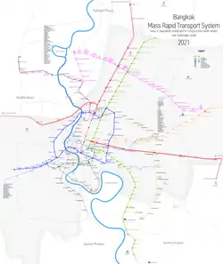
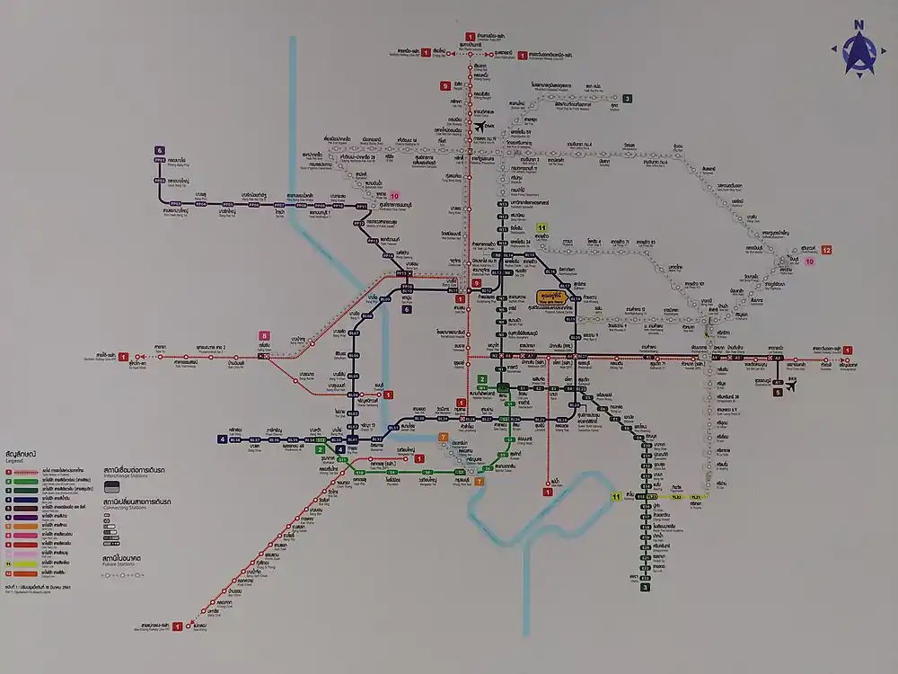
Opened transit lines map as of December 2020 | |
| Overview | |
|---|---|
| Owner | BMA, MRTA, and SRT |
| Locale | Bangkok Metropolitan Region |
| Transit type | Rapid transit consisting of Heavy rail (metro & commuter rail) lines & light rail (monorail & people mover) lines |
| Number of lines | Current: 6 lines (Total planned: 15 lines) |
| Number of stations | 123* out of planned 310* *Internal interchange stations are counted only once |
| Daily ridership | 1.5 million |
| Operation | |
| Began operation | December 5, 1999 |
| Operator(s) | BTS, BEM, and SRT |
| Technical | |
| System length | 2020 Current Service: 169.25 km 2020 Under Construction: 136 km 2029 Planned total: 540 km |
| Electrification | Overhead line and Third rail |
| Top speed | MRT: 80 km/h BTS: 80 km/h Airport Rail Link(ARL): 160 km/h SRT Red Lines: 160 km/h |
Early Versions
Mass Rapid Transit Systems Master Plan (MTMP)
The first version of the plan, endorsed by the cabinet on 27 September 1994 and to be implemented from 1995 to 2011, consisted of an extension of 135 kilometres (84 mi) to the three systems already in progress (the MRT Blue Line, the Sukhumvit and Silom lines of the BTS Skytrain and the Bangkok Elevated Road and Train System (BERTS)), which would have had a combined length of 103 kilometres (64 mi).[1]
Urban Rail Transportation Master Plan in Bangkok and Surrounding Areas (URMAP)
Following the 1997 Asian Financial Crisis and the cancellation of the BERTS, a system totalling 375 kilometres (233 mi) to begin in 2001 was proposed, to be developed in three stages: 141.9 kilometres (88.2 mi) during 2001–11, 158.2 kilometres (98.3 mi) during 2012–21 and 75.3 kilometres (46.8 mi) from 2022 onwards.[1]
Bangkok Mass Transit Master Plan (BMT)
Due to the slow progress of development following URMAP, a new plan was drafted consisting of 475.05 kilometres (295.18 mi) of rail in addition to the then-completed MRT Blue Line, the Sukhumvit and Silom BTS lines, the MRT purple line, and the Airport Rail Link to undergo rapid development during 2010–29. The plan was approved by the cabinet in 2016, and consisted of the following extensions:
- Light Green Line: North–south extension of the BTS to Khu Khot and Kheha Samut Prakan
- Dark Green Line: West extension of the BTS to Yot Se
- Blue Line: Extension of the MRT Blue Line to complete a quasi circle line with a branch to Lak Song
- Purple Line: South extension to Rat Burana is under study
- Orange Line: Running east–west Min Buri to Bang Khun Non
- SRT Dark Red Line: Running north–southwest from Rangsit to Bang Sue to Maha Chai
- SRT Light Red Line: running east–west from Hua Mak to Sala Ya
- Airport Rail Link: North extension to Don Mueang
M-Map
The first M-Map plan was endorsed by the Commission for the Management of Land Traffic in 2010.[2] It designates eight primary routes, consisting of two commuter rail lines, an airport rail link, and five rapid transit lines, as well as five feeder lines. The routes, totaling 555.74 kilometres (345.32 mi), are to be constructed within a development period of twenty years (2010–29). They were:[3]
| Primary lines | ||
|---|---|---|
| Rapid transit type | Line | Route |
| Heavy rail: Commuter | SRT Dark Red Line | Thammasat University – Rangsit – Bang Sue – Hua Lamphong – Bang Bon – Maha Chai |
| SRT Light Red Line | Sala Ya – Taling Chan – Hua Mak | |
| Heavy rail: Metro | SRT Airport Rail Link | Suvarnabhumi – Phaya Thai – Bang Sue – Don Mueang |
| Heavy rail: Metro | BTS Light Green Line and extension of BTS | East Outer Ring Road – Khu Khot – Saphan Mai – Mo Chit – On Nut – Bearing – Kheha Samut Prakan – Bang Pu |
| BTS Dark Green Line and extension of BTS | Yot Se – Saphan Taksin – Bang Wa – Taling Chan | |
| MRT Blue Line and extension of MRT | Tha Phra – Bang Sue – Hua Lamphong – Tha Phra – Lak Song – Phutthamonthon Sai 4 | |
| MRT Purple Line | Khlong Bang Phai – Tao Poon – Khru Nai | |
| MRT Orange Line | Bang Khun Non – Thailand Cultural Centre – Yaek Rom Klao | |
| Feeder lines | ||
| Rapid transit type | Line | Route |
| Monorail | MRT Pink Line | Nonthaburi Civic Center – Min Buri |
| MRT Yellow Line | Lat Phrao - Samrong | |
| Grey Line | Watcharaphon – Rama IX Bridge | |
| Light Blue Line | Pracha Songkhro – Chong Nonsi | |
Development would be divided into three stages, in addition to those lines already open or under construction.[4]
M-Map 2
The 2010 M-Map did not reflect more recent changes to the priority of constructing new rapid transit lines in Bangkok. While the Orange, Pink and Yellow lines received approval, the Grey Line and Light Blue lines are still under study. In March 2017 the Minister of Transport announced the development of M-Map 2[5] to be written by the Office of Transport and Traffic Policy and Planning in conjunction with the Japan International Cooperation Agency. The initial map listed the following lines in the current plan:[6]
| Primary lines | ||
|---|---|---|
| Rapid transit type | Line | Route |
| Heavy rail: Commuter | SRT Dark Red Line | Thammasat University – Rangsit – Bang Sue – Hua Lamphong – Bang Bon – Maha Chai |
| SRT Light Red Line | Sala Ya – Taling Chan – Hua Mak | |
| Heavy rail: Commuter | SRT Airport Rail Link and extension | Suvarnabhumi – Phaya Thai – Bang Sue – Don Mueang |
| Heavy rail: Metro | BTS Light Green Line | East Outer Ring Road – Khu Khot – Saphan Mai – Mo Chit – On Nut – Bearing – Kheha Samut Prakan – Bang Pu |
| BTS Dark Green Line | Yot Se – Saphan Taksin – Bang Wa – Taling Chan | |
| MRT Blue Line | Tha Phra – Bang Sue – Hua Lamphong – Tha Phra – Lak Song – Phutthamonthon Sai 4 | |
| MRT Purple Line | Khlong Bang Phai – Tao Poon – Khru Nai | |
| MRT Orange Line | Bang Khun Non – Thailand Cultural Centre – Yaek Rom Klao | |
| Feeder lines | ||
| Rapid transit type | Line | Route |
| [tram] | MRT Pink Line and Impact Link Spur Line | Nonthaburi Civic Center – (Si Rat – Mueang Thong Lake) – Min Buri |
| MRT Yellow Line | Phaholyothin 24 – Lat Phrao – Samrong | |
Other lines not in M-Map
The Grey and Light Blue line remain under study. The MRT Brown Line which will link Nonthaburi Civic Center with the Lam Sali Intersection has been approved.
Additionally, a Gold Line from Krung Thonburi – Memorial Bridge, partially funded by property developer Siam Piwat is under construction outside of the M-Map framework.
| Rapid transit type | Line | Route |
|---|---|---|
| Monorail | BMA Grey Line | Watcharaphon – Rama IX Bridge |
| Light Blue Line | Pracha Songkhro – Chong Nonsi | |
| MRT Brown Line | Nonthaburi Civic Center – Yaek Lam Sali | |
| Automated guideway transit | BMA Gold Line | Krung Thonburi – Memorial Bridge |
| Tram | Light Cyan Line | Bang Na – Suvarnabhumi |
Overview
| Overview as of June 2020 | Distance (km) | Metro Lines |
|---|---|---|
| Current Operations | 169.25 km | Silom Line, Sukhumvit Line, Blue Line, Airport Rail Link, Purple Line, Gold Line |
| Under construction | 124 km | Pink Line (2022), Yellow Line (2022), SRT Light Red Line (2021), SRT Dark Red Line (2021), Orange Line (2023), |
| Future planning | 257.5 km | SRT Light Red Line exts, SRT Dark Red Line exts, Airport Rail Link ext, Purple Line southern ext, Orange Line western ext, Brown Line, BTS exts, BMA Grey Line, |
| Total Planned | 540 km |
Current Operations
| Line | Operator | Route | Length km |
Nr of Stations |
Year Opened |
Last Extension |
|---|---|---|---|---|---|---|
| Silom Line | BTS | National Stadium - Bang Wa | 14.0 | 13 | 1999 | 2015 |
| Sukhumvit Line | BTS | Khu Khot - Kheha | 53.9 | 47 | 1999 | 2020 |
| Blue Line | BEM | Tha Phra - Bang Sue - Lak Song | 48.0 | 38 | 2004 | 2020 |
| Airport Rail Link | SRT | Phaya Thai-Suvarnabhumi Airport | 28.6 | 8 | 2010 | 2018 |
| Purple Line | BEM | Tao Poon- Klong Bang Phai | 23.6 | 16 | 2016 | 2019 |
| Gold Line | BTS | Krung Thonburi - Khlong San | 1.8 | 3 | 2020 | 2020 |
| Total | 169.9 |
Under construction
| Line | Rapid transit type | Owner: Operator (if awarded) | Stations | Distance
(km) |
Route | Under construction since | Scheduled operation |
|---|---|---|---|---|---|---|---|
| MRT Orange Line Eastern section | Heavy rail: Metro | MRTA | 17 | 22.5 | Thailand Cultural Centre ↔ Yaek Romklao | June 2017 | 2023[7][8] |
| SRT Dark Red Line | Heavy rail: Commuter | SRT | 9[9] | 21.6 | Rangsit ↔ Bang Sue | May 2013 | March 2021[10] |
| SRT Light Red Line | 5[9] | 15 | Taling Chan ↔ Bang Sue | Completed[9] | |||
| MRT Pink Line | Monorail | MRTA: NBM | 30 | 34.5 | Nonthaburi Civic Center ↔ Min Buri | July 2018 | 2022[11] |
| MRT Yellow Line | MRTA: EBM | 23 | 30.4 | Lat Phrao – Samrong | October 2021[10][7][8] | ||
| Total (as of January 2021) | 124 km | ||||||
Future Planning
| Line | Rapid transit type | Owner | Stations to be added |
Projected Operation | Length km |
Length mile |
Terminus |
|---|---|---|---|---|---|---|---|
| Sukhumvit Line | Heavy rail: Metro | BMA | 7 | n/a | 6.5 | 4.0 | Khu Khot↔ Eastern Outer Ring |
| Sukhumvit Line | Heavy rail: Metro | BMA | est. 2021 | Kheha Samut Prakan↔Bang Pu | |||
| Silom Line | Heavy rail: Metro | BMA | 22 | n/a | 7.50 | 4.66 | Bang Wa↔Taling Chan |
| Silom Line | Heavy rail: Metro | BMA | 13 | n/a | 1.0 | 0.62 | National Stadium↔Yot Se |
| Blue Line western extension | Heavy rail: Metro | MRTA | 4 | n/a | 8.0 | 5.0 | Lak Song ↔ Phutthamonthon Sai 4 |
| Orange Line western extension | Heavy rail: Metro | MRTA | 12 | est. 2026 | 17.5 | 10.9 | Thailand Cultural Centre ↔ Bang Khun Non |
| Purple Line southern extension | Heavy rail: Metro | MRTA | 17 | est. 2025 | 23.60 | 14.66 | Tao Poon ↔ Rat Burana |
| SRT Dark Red Line (phase II) | Heavy rail: Commuter | SRT | 8 | n/a | 6.05 | 3.76 | Bang Sue ↔ Hua Lamphong |
| SRT Dark Red Line (phase III) | Heavy rail: Commuter | SRT | 4 | est. 2024 | 8.75 | 5.44 | Thammasat ↔ Rangsit |
| SRT Dark Red Line (phase IV) | Heavy rail: Commuter | SRT | 8 | n/a | 13.18 | 8.19 | Hua Lamphong ↔ Bang Bon |
| SRT Dark Red Line (phase V) | Heavy rail: Commuter | SRT | 12 | n/a | 21.00 | 13.05 | Bang Bon ↔ Maha Chai |
| SRT Light Red Line (phase II) | Heavy rail: Commuter | SRT | 5 | n/a | 18.80 | 11.68 | Bang Sue ↔ Hua Mak |
| SRT Light Red Line (phase III) | Heavy rail: Commuter | SRT | 5,.,. | n/a | 12.98 | 8.07 | Taling Chan ↔ Sala Ya Station |
| SRT Light Red Line (phase III) | Heavy rail: Commuter | SRT | 23 | n/a | 5.38 | 3.34 | Taling Chan ↔ Thonburi-Siriraj |
| Airport Rail Link (phase II) | Heavy rail: Commuter | SRT | 1 | est. 2024 | 6.68 | 4.15 | Bang Sue ↔ Phaya Thai |
| Airport Rail Link (phase III) | Heavy rail: Commuter | SRT | 1 | est. 2024 | 15.40 | 9.57 | Don Mueang ↔ Bang Sue |
| Grey Line | Monorail | BMA | 21 | n/a | 26.0 | 16.2 | Vatcharapol ↔ Rama 9 Bridge |
| Light Cyan Line | Light Rail | BMA | 14 | n/a | 24.0 | 14.9 | Bang Na ↔ Suvarnabhumi |
| Brown Line | Monorail | MRTA | 21 | est. 2024 | 22.0 | 13.7 | Nonthaburi Civic Center↔Lam Sali |
References
- "Archived copy" เส้นทางปรับแผนรถไฟฟ้า. Mass Rapid Transit Master Plan in Bangkok Metropolitan Region website (in Thai). Office of Transport and Traffic Policy and Planning. Archived from the original on 2 January 2011. Retrieved 16 January 2012.CS1 maint: archived copy as title (link)
- Hoonsara, Samatcha; Jeerawan Prasomsap (9 February 2010). "Commission approves new Skytrain routes". The Nation. Archived from the original on 2011-02-21. Retrieved 16 January 2012.
- แผนแม่บทระบบขนส่งมวลชนทางรางในเขตกรุงเทพฯและปริมณฑล พ.ศ.2553-2572 [Mass Rapid Transit Master Plan in Bangkok Metropolitan Region] (PDF) (in Thai). Office of Transport and Traffic Policy and Planning. Retrieved 16 January 2012.
- ความก้าวหน้าโครงการ. Mass Rapid Transit Master Plan in Bangkok Metropolitan Region website (in Thai). Office of Transport and Traffic Policy and Planning. Archived from the original on 11 January 2012. Retrieved 16 January 2012.
- ไทย-ญี่ปุ่น เร่งศึกษาแผนแม่บทรถไฟฟ้า. banmuang.co.th (in Thai). Retrieved 2017-08-12.
- "Development of the 2nd Blueprint for Bangkok Mass Rapid Transit Master Plan (M-MAP2)" (PDF).
- www.dotproperty.co.th (18 December 2018). อัปเดต ความคืบหน้ารถไฟฟ้า ปี 2019 แต่ละสายมีภาพรวมพร้อมใกล้เปิดให้บริการหรือยัง (in Thai). Retrieved 18 December 2018.
- www.thairath.co.th (7 January 2019). อัปเดตรถไฟฟ้า "มหานครระบบราง" พลิกโฉมหน้าการจราจรกรุงเทพฯ (in Thai). Retrieved 7 January 2019.
- "ครม.อนุมัติโครงการรถไฟสายสีแดงเข้ม-แดงอ่อน มูลค่า 4.4 หมื่นลบ". ryt9.com.
- "'ศบศ.' เร่งลงทุน 1.2 ล้านล้าน ลุยเมกะโปรเจคเสริมแกร่งหลังโควิด". www.bangkokbiznews.com/.
- January 2021 https://www.bangkokpost.com/business/2049527/mass-transit-vow-reaffirmed January 2021 Check
|url=value (help). Missing or empty|title=(help)
External links
| Wikimedia Commons has media related to Mass Rapid Transit Master Plan in Bangkok Metropolitan Region. |
Public transport systems in Bangkok Metropolitan Region | ||||||||||||||||||||||||||||||||||||||
|---|---|---|---|---|---|---|---|---|---|---|---|---|---|---|---|---|---|---|---|---|---|---|---|---|---|---|---|---|---|---|---|---|---|---|---|---|---|---|
| Railways |
| .svg.png.webp) | ||||||||||||||||||||||||||||||||||||
| Roads |
| |||||||||||||||||||||||||||||||||||||
| Buses |
| |||||||||||||||||||||||||||||||||||||
| Water transport |
| |||||||||||||||||||||||||||||||||||||
| High-speed rail | |
|---|---|
| Commuter rail |
|
| Rapid transit | |
| Monorail |
|
| AGT, Light rail & Tram |
|
| Bus rapid transit |
|
| ||
| Major operators |  | |
| Lines | ||
| Lists | ||
| Notable trains | ||
| Rolling Stock | ||
| Indonesia |
| ||||||||||||||
|---|---|---|---|---|---|---|---|---|---|---|---|---|---|---|---|
| Malaysia | |||||||||||||||
| Myanmar | |||||||||||||||
| Philippines |
| ||||||||||||||
| Singapore | |||||||||||||||
| Thailand | |||||||||||||||
| Vietnam |
| ||||||||||||||
Note: Under construction & planned lines are in Italics | |||||||||||||||