Anoka County, Minnesota
Anoka County (/əˈnoʊkə/ ə-NOH-kə) is the fourth-most-populous county in the U.S. state of Minnesota. As of the 2010 United States census, the population was 330,854.[2] The county seat and namesake of the county is the city of Anoka,[3] which is derived from the Dakota word anokatanhan meaning "on (or from) both sides," referring to its location on the banks of the Rum River.[4] The largest city in the county is the city of Blaine, the thirteenth-largest city in Minnesota and the eighth-largest Twin Cities suburb.
Anoka County | |
|---|---|
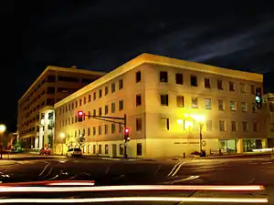 The Anoka County Courthouse and Government Center in downtown Anoka, July 2009 | |
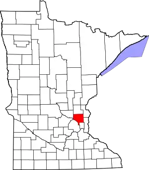 Location within the U.S. state of Minnesota | |
 Minnesota's location within the U.S. | |
| Coordinates: 45°16′N 93°14′W | |
| Country | |
| State | |
| Founded | May 23, 1857[1] |
| Named for | City of Anoka |
| Seat | Anoka |
| Largest city | Blaine |
| Area | |
| • Total | 446 sq mi (1,160 km2) |
| • Land | 423 sq mi (1,100 km2) |
| • Water | 23 sq mi (60 km2) 5.2%% |
| Population (2010) | |
| • Total | 339,534 |
| • Estimate (2019) | 356,921 |
| • Density | 831/sq mi (321/km2) |
| Time zone | UTC−6 (Central) |
| • Summer (DST) | UTC−5 (CDT) |
| Congressional districts | 3rd, 5th, 6th |
| Website | www |
Anoka County comprises the north portion of the Minneapolis-St. Paul-Bloomington, MN-WI Metropolitan Statistical Area, the largest metropolitan area in the state and the sixteenth-largest in the United States with about 3.64 million residents.
The county is bordered by the counties of Isanti on the north, Chisago and Washington on the east, Hennepin and Ramsey on the south, Sherburne on the west, and the Mississippi River on the southwest. The Rum River cuts through the county and was the site of many early European settlements. It was a common route to the Mille Lacs Lake, the spiritual homeland of the Ojibwe people. Father Louis Hennepin traveled the river in his first exploration of the region.[5] The area became a center of fur trade and logging as French and French Canadian communities grew in the cities of Anoka and Centerville.[6] Organized in 1857, the county's southern border eventually met Minneapolis and has become a predominantly suburban area following the construction of Interstate 35W. The county is home to local Twin Cities destinations such as the Heights Theater in Columbia Heights and Northtown Mall and the National Sports Center in Blaine.
History
Anoka County was organized by an act of the Minnesota Territorial Legislature on May 23, 1857, the year prior to Minnesota's admission to the Union. It was formed from parts of Ramsey County and Benton County; the Rum River previously divided the line between the two counties. The boundaries were mainly the same as they are now, except for a small part of the southeastern tip along the Mississippi River and at the south, formerly known as Manomin County. It was a small portion that connected to Ramsey and occupied one-third of the congressional township. It was then attached to Anoka County by constitutional amendment November 2, 1869. It became known as Fridley in 1879.
The first white men to explore what is now Anoka County were the Franciscan friar Louis Hennepin and his party. Fur traders soon began to settle in the area which is now Ramsey County. They settled on the Rum River and more people were attracted to the area. A community was created which is now called Anoka.
Geography
The Mississippi River flows southeasterly along the county's southwestern boundary. The Rum River flows southerly through the western part of the county, discharging into the Mississippi at the county's southwestern boundary. The terrain consists of low rolling wooded hills.[8] The terrain slopes to the south and east; its highest point is a small hillock 1.2 mile (1.9 km) east of the county's northwest corner, at 1,100' (335m) ASL.[9] Otherwise the terrain's highest point is along the western part of the north boundary line, at 1,083' (330m) ASL.[10] The county has a total area of 446 square miles (1,160 km2), of which 423 square miles (1,100 km2) is land and 23 square miles (60 km2) (5.2%) is water.[11]
Lakes
- Bunker Lake
- Cedar Lake
- Coon Lake
- Crooked Lake
- Ham Lake
- Laddie Lake
- Lake George
- McKay Lake
- Moore Lake
- Round Lake
- Spring Lake
- Smith Lake
Rivers
- Cedar Creek
- Coon Creek
- Crooked Brook
- Ford Brook
- Hardwood Creek
- Mahoney Brook
- Mississippi River
- Rice Creek
- Rum River
- Sand Creek
- Seelye Brook
- Trott Brook
- Pheasant creek
Major highways
Adjacent counties
- Isanti County - north
- Chisago County - northeast
- Washington County - east
- Ramsey County - southeast
- Hennepin County - southwest
- Sherburne County - northwest
Protected areas
- Bethel Wildlife Management Area
- Boot Lake Scientific and Natural Area
- Bunker Hills Regional Park
- Carl E Bonnell Wildlife Management Area
- Carlos Avery State Wildlife Management Area
- Cedar Creek Conservation Area
- Coon Rapids Dam Regional Park
- East Bethel Booster Park
- Gordie Mikkelson Wildlife Management Area
- Helen Allison Savanna Scientific and Natural Area
- Lake George Regional Park
- Martin Island-Linwood Lakes Regional Park
- Mississippi National River and Recreation Area (part)
- Rice Creek Chain of Lakes Park Preserve
- Robert and Marilyn Burman Wildlife Management Area
Climate and weather
| Anoka, Minnesota | ||||||||||||||||||||||||||||||||||||||||||||||||||||||||||||
|---|---|---|---|---|---|---|---|---|---|---|---|---|---|---|---|---|---|---|---|---|---|---|---|---|---|---|---|---|---|---|---|---|---|---|---|---|---|---|---|---|---|---|---|---|---|---|---|---|---|---|---|---|---|---|---|---|---|---|---|---|
| Climate chart (explanation) | ||||||||||||||||||||||||||||||||||||||||||||||||||||||||||||
| ||||||||||||||||||||||||||||||||||||||||||||||||||||||||||||
| ||||||||||||||||||||||||||||||||||||||||||||||||||||||||||||
In recent years, average temperatures in the county seat of Anoka have ranged from a low of 5 °F (−15 °C) in January to a high of 81 °F (27 °C) in July, although a record low of −50 °F (−46 °C) was recorded in January 2019 and a record high of 103 °F (39 °C) was recorded in July 1988. Average monthly precipitation ranged from 0.87 inches (22 mm) in February to 4.45 inches (113 mm) in July.[12]
Demographics
| Historical population | |||
|---|---|---|---|
| Census | Pop. | %± | |
| 1860 | 2,106 | — | |
| 1870 | 3,940 | 87.1% | |
| 1880 | 7,108 | 80.4% | |
| 1890 | 9,884 | 39.1% | |
| 1900 | 11,313 | 14.5% | |
| 1910 | 12,493 | 10.4% | |
| 1920 | 15,626 | 25.1% | |
| 1930 | 18,415 | 17.8% | |
| 1940 | 22,443 | 21.9% | |
| 1950 | 35,579 | 58.5% | |
| 1960 | 85,916 | 141.5% | |
| 1970 | 154,712 | 80.1% | |
| 1980 | 195,998 | 26.7% | |
| 1990 | 243,641 | 24.3% | |
| 2000 | 298,084 | 22.3% | |
| 2010 | 330,844 | 11.0% | |
| 2019 (est.) | 356,921 | [13] | 7.9% |
| US Decennial Census[14] 1790-1960[15] 1900-1990[16] 1990-2000[17] 2010-2019[2] | |||
The 2000 United States Census listed 298,084 people, 106,428 households, and 79,395 families in the county. The population density was 705 sq mi (272/km2). There were 108,091 housing units at an average density of 256/sqmi (98.7/km2). The 2010 United States Census found that 330,844 people were in the county.[18]
At the time of the 2000 Census, the racial makeup of the county was 93.64 percent white, 1.60 percent black or African American, 0.70 percent Native American, 1.69 percent Asian, 0.02 percent Pacific Islander, 0.65 percent from other races, and 1.71 percent from two or more races, and 1.66 percent of the population were Hispanic or Latino of any race. The 2000 Census found 30.2 percent were of German, 14.3 percent Norwegian, 9.0 percent Swedish, 7.3 percent Irish and 5.9 percent Polish ancestry.
There were 106,428 households, out of which 39.90% had children under the age of 18 living with them, 60.70% were married couples living together, 9.80% had a female householder with no husband present, and 25.40% were non-families. Of all households, 19.30% were made up of individuals, and 5.30% had someone living alone who was 65 years of age or older. The average household size was 2.77 and the average family size was 3.19.
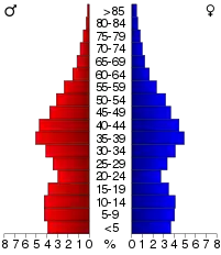
The county population contained 28.90% under the age of 18, 8.30% from 18 to 24, 34.10% from 25 to 44, 21.60% from 45 to 64, and 7.10% who were 65 years of age or older. The median age was 34 years. For every 100 females there were 101.10 males. For every 100 females age 18 and over, there were 99.30 males.
The median income for a household in the county was $57,754, and the median income for a family was $64,261. Males had a median income of $41,527 versus $30,534 for females. The per capita income for the county was $23,297. About 2.90% of families and 4.20% of the population were below the poverty line, including 4.90% of those under age 18 and 4.50% of those age 65 or over.
Government and politics
On a national level, Anoka county has voted for the Republican presidential candidate from 2000 onward. However, incumbent Democratic-Farmer-Labor Senator Amy Klobuchar defeated Jim Newberger by over 20,000 votes here in the 2018 midterms; Klobuchar also won this county in 2006 and 2012. Despite this, Republican Karin Housley narrowly defeated Democrat Tina Smith in the concurrent Senate special election in 2018, despite Smith winning the overall election by a margin of over 10 points.
County Commissioners
As of June 2019
- District 1 (western Anoka, Bethel, Nowthen, western Oak Grove, Ramsey, Saint Francis) - Matt Look
- District 2 (northeastern Andover, northern Blaine, East Bethel, Ham Lake, eastern Oak Grove) - Julie Braastad
- District 3 (central Blaine, northern Fridley, Spring Lake Park) - Robyn West
- District 4 (Columbia Heights, Fridley, Hilltop, part of Spring Lake Park) - Mandy Meisner
- District 5 (southern Andover and eastern Coon Rapids) - Mike Gamache
- District 6 (southeastern Blaine, Centerville, Circle Pines, Columbus, Lexington, Lino Lakes, Linwood) - Jeff Reinert
- District 7 (eastern Anoka, western Andover and western Coon Rapids) - Scott Schulte, Chair
National elections
| Year | Republican | Democratic | Third parties |
|---|---|---|---|
| 2020 | 49.7% 104,902 | 47.8% 100,893 | 2.5% 5,337 |
| 2016 | 50.3% 93,339 | 40.6% 75,500 | 9.1% 16,919 |
| 2012 | 50.1% 93,430 | 47.5% 88,614 | 2.4% 4,421 |
| 2008 | 50.1% 91,357 | 47.7% 86,976 | 2.1% 3,891 |
| 2004 | 52.8% 91,853 | 46.1% 80,226 | 1.1% 1,987 |
| 2000 | 47.6% 69,256 | 46.7% 68,008 | 5.7% 8,355 |
| 1996 | 33.7% 41,745 | 51.4% 63,756 | 14.9% 18,521 |
| 1992 | 30.4% 39,458 | 42.0% 54,621 | 27.7% 35,941 |
| 1988 | 44.3% 46,853 | 54.8% 57,953 | 1.0% 1,003 |
| 1984 | 47.8% 46,578 | 51.6% 50,305 | 0.6% 557 |
| 1980 | 37.7% 33,100 | 51.8% 45,532 | 10.5% 9,211 |
| 1976 | 35.6% 27,863 | 61.5% 48,173 | 2.9% 2,279 |
| 1972 | 49.8% 29,546 | 47.2% 28,031 | 3.0% 1,783 |
| 1968 | 32.6% 16,358 | 61.2% 30,656 | 6.2% 3,120 |
| 1964 | 29.3% 13,201 | 70.5% 31,714 | 0.2% 90 |
| 1960 | 40.9% 14,114 | 58.9% 20,324 | 0.2% 73 |
| 1956 | 44.4% 9,359 | 55.5% 11,697 | 0.2% 36 |
| 1952 | 44.1% 7,425 | 55.5% 9,344 | 0.4% 70 |
| 1948 | 32.3% 3,853 | 64.8% 7,730 | 2.9% 346 |
| 1944 | 41.8% 3,958 | 57.4% 5,431 | 0.8% 79 |
| 1940 | 43.5% 4,302 | 55.7% 5,501 | 0.8% 80 |
| 1936 | 32.7% 2,586 | 56.9% 4,501 | 10.4% 822 |
| 1932 | 38.0% 2,718 | 59.5% 4,253 | 2.5% 181 |
| 1928 | 59.1% 3,816 | 39.8% 2,571 | 1.2% 75 |
| 1924 | 57.2% 3,146 | 8.3% 458 | 34.5% 1,901 |
| 1920 | 72.1% 3,505 | 17.8% 865 | 10.1% 489 |
| 1916 | 49.0% 1,262 | 45.4% 1,171 | 5.6% 145 |
| 1912 | 27.0% 562 | 28.4% 591 | 44.5% 926 |
| 1908 | 69.0% 1,577 | 26.7% 610 | 4.3% 99 |
| 1904 | 82.3% 1,557 | 15.0% 283 | 2.8% 53 |
| 1900 | 70.9% 1,511 | 26.0% 555 | 3.1% 66 |
| 1896 | 64.9% 1,553 | 33.1% 791 | 2.1% 49 |
| 1892 | 52.8% 1,002 | 37.9% 720 | 9.3% 177 |
Communities
Cities
- Andover
- Anoka
- Bethel
- Blaine (Partially in Ramsey County)
- Centerville
- Circle Pines
- Columbia Heights
- Columbus
- Coon Rapids
- East Bethel
- Fridley
- Ham Lake
- Hilltop
- Lexington
- Lino Lakes
- Nowthen
- Oak Grove
- Ramsey
- Saint Francis (Partially in Isanti County)
- Spring Lake Park (Partially in Ramsey County)
Township
Census-designated place
Unincorporated community
References
- "Minnesota Place Names". Minnesota Historical Society. Archived from the original on June 20, 2012. Retrieved March 17, 2014.
- "State & County QuickFacts". United States Census Bureau. Archived from the original on July 6, 2011. Retrieved August 30, 2013.
- "Find a County". National Association of Counties. Archived from the original on May 31, 2011. Retrieved June 7, 2011.
- Stephen Return Riggs, A Dakota-English Dictionary (editor, James Owen Dorsey). Government Printing Office, 1892, p. 37.
- "Anoka County Early Years". Anoka County Historical Society. Archived from the original on August 20, 2008. Retrieved October 22, 2008.
- June D. Holmquist (1981). They Chose Minnesota. Minnesota Historical Society Press. p. 40. ISBN 978-0-87351-231-2.
- Nelson, Steven (2011). Savanna Soils of Minnesota. Minnesota: Self. pp. 61-64. ISBN 978-0-615-50320-2
- Anoka County MN Google Maps (accessed 4 March 2019)
- Anoka County High Point, Minnesota. PeakBagger.com (accessed 4 May 2019)
- ""Find an Altitude/Anoka County MN" Google Maps (accessed 4 March 2019)". Archived from the original on May 21, 2019. Retrieved March 4, 2019.
- "2010 Census Gazetteer Files". US Census Bureau. August 22, 2012. Archived from the original on October 6, 2014. Retrieved October 5, 2014.
- "Monthly Averages for Anoka MN". The Weather Channel. Archived from the original on October 6, 2014. Retrieved February 13, 2011.
- "Population and Housing Unit Estimates". Retrieved March 26, 2020.
- "US Decennial Census". US Census Bureau. Archived from the original on April 26, 2015. Retrieved October 5, 2014.
- "Historical Census Browser". University of Virginia Library. Retrieved October 5, 2014.
- "Population of Counties by Decennial Census: 1900 to 1990". US Census Bureau. Retrieved October 5, 2014.
- "Census 2000 PHC-T-4. Ranking Tables for Counties: 1990 and 2000" (PDF). US Census Bureau. Retrieved October 5, 2014.
- "Archived copy". Archived from the original on July 6, 2011. Retrieved July 7, 2011.CS1 maint: archived copy as title (link)
- Leip, David. "Atlas of US Presidential Elections". uselectionatlas.org. Retrieved April 17, 2018.
External links
- Anoka County government's website
- Anoka County Historical Society Digital Collection, Minnesota Reflections
Places adjacent to Anoka County, Minnesota | ||||||||||
|---|---|---|---|---|---|---|---|---|---|---|
| ||||||||||
Municipalities and communities of Anoka County, Minnesota, United States | ||
|---|---|---|
| Cities | Map of Minnesota highlighting Anoka County | |
| Township | ||
| CDP | ||
| Unincorporated community | ||
| Ghost towns/Neighborhoods | ||
| Footnotes | ‡This populated place also has portions in an adjacent county or counties | |
| ||

| Authority control |
|---|