Montbron
Montbron is a commune in the Charente department in southwestern France on the Tardoire river.
Montbron | |
|---|---|
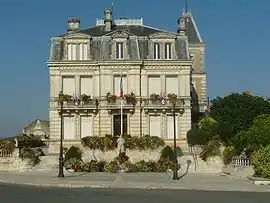 Town hall | |
 Coat of arms | |
Location of Montbron 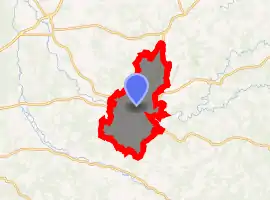
| |
 Montbron  Montbron | |
| Coordinates: 45°40′05″N 0°30′06″E | |
| Country | France |
| Region | Nouvelle-Aquitaine |
| Department | Charente |
| Arrondissement | Angoulême |
| Canton | Val de Tardoire |
| Intercommunality | Seuil Charente-Périgord |
| Government | |
| • Mayor (2008–2014) | Gwenhaël François |
| Area 1 | 43.34 km2 (16.73 sq mi) |
| Population (2017-01-01)[1] | 2,028 |
| • Density | 47/km2 (120/sq mi) |
| Time zone | UTC+01:00 (CET) |
| • Summer (DST) | UTC+02:00 (CEST) |
| INSEE/Postal code | 16223 /16220 |
| Elevation | 95–287 m (312–942 ft) (avg. 150 m or 490 ft) |
| 1 French Land Register data, which excludes lakes, ponds, glaciers > 1 km2 (0.386 sq mi or 247 acres) and river estuaries. | |
Population
| Year | Pop. | ±% |
|---|---|---|
| 1793 | 2,668 | — |
| 1800 | 3,101 | +16.2% |
| 1806 | 2,980 | −3.9% |
| 1821 | 3,136 | +5.2% |
| 1831 | 3,172 | +1.1% |
| 1841 | 3,189 | +0.5% |
| 1846 | 3,276 | +2.7% |
| 1851 | 3,331 | +1.7% |
| 1856 | 3,152 | −5.4% |
| 1861 | 3,240 | +2.8% |
| 1866 | 3,300 | +1.9% |
| 1872 | 3,168 | −4.0% |
| 1876 | 3,264 | +3.0% |
| 1881 | 3,323 | +1.8% |
| 1886 | 3,426 | +3.1% |
| 1891 | 3,135 | −8.5% |
| 1896 | 3,027 | −3.4% |
| 1901 | 2,983 | −1.5% |
| 1906 | 3,005 | +0.7% |
| 1911 | 2,729 | −9.2% |
| 1921 | 2,461 | −9.8% |
| 1926 | 2,552 | +3.7% |
| 1931 | 2,530 | −0.9% |
| 1936 | 2,563 | +1.3% |
| 1946 | 2,695 | +5.2% |
| 1954 | 2,433 | −9.7% |
| 1962 | 2,469 | +1.5% |
| 1968 | 2,383 | −3.5% |
| 1975 | 2,541 | +6.6% |
| 1982 | 2,604 | +2.5% |
| 1990 | 2,422 | −7.0% |
| 1999 | 2,242 | −7.4% |
| 2008 | 2,163 | −3.5% |
See also
References
- "Populations légales 2017". INSEE. Retrieved 6 January 2020.
| Wikimedia Commons has media related to Montbron. |
| Authority control |
|---|
This article is issued from Wikipedia. The text is licensed under Creative Commons - Attribution - Sharealike. Additional terms may apply for the media files.