National Register of Historic Places listings in Brookings County, South Dakota
This is a list of the National Register of Historic Places listings in Brookings County, South Dakota.
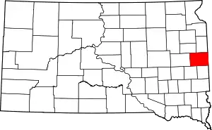
Location of Brookings County in South Dakota
This is intended to be a complete list of the properties and districts on the National Register of Historic Places in Brookings County, South Dakota, United States. The locations of National Register properties and districts for which the latitude and longitude coordinates are included below, may be seen in a map.[1]
There are 40 properties and districts listed on the National Register in the county. Another property was once listed but has since been removed.
- This National Park Service list is complete through NPS recent listings posted January 29, 2021.[2]
Current listings
| [3] | Name on the Register[4] | Image | Date listed[5] | Location | City or town | Description |
|---|---|---|---|---|---|---|
| 1 | Brookings Central Residential Historic District | 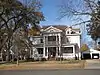 Brookings Central Residential Historic District |
June 3, 1994 (#94000558) |
Roughly bounded by 3rd St., 6th St. (Highway 14), Medary Ave., and 5th Ave.; also 521 and 601 4th St. 44°18′35″N 96°47′33″W |
Brookings | 4th St. addresses represent a boundary increase |
| 2 | Brookings City Hall | 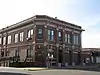 Brookings City Hall |
June 17, 1982 (#82003914) |
4th St. 44°18′32″N 96°47′57″W |
Brookings | |
| 3 | Brookings Commercial Historic District | 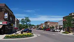 Brookings Commercial Historic District |
April 19, 1988 (#88000029) |
Roughly along Main Ave. between the former C&NW railroad line and the alley north of 5th St. 44°18′32″N 96°47′53″W |
Brookings | |
| 4 | Brookings County Courthouse | 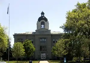 Brookings County Courthouse |
December 12, 1976 (#76001715) |
4th St. and 6th Ave. 44°18′32″N 96°47′43″W |
Brookings | |
| 5 | Brookings University Residential Historic District | February 12, 1999 (#99000210) |
Roughly bounded by Harvey Dunn St., Medary Ave., 6th St., and Main Ave. 44°18′52″N 96°47′34″W |
Brookings | ||
| 6 | W. A. Caldwell House | 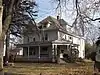 W. A. Caldwell House |
November 3, 1986 (#86002990) |
804 6th Ave. 44°18′52″N 96°47′38″W |
Brookings | |
| 7 | Carnegie Public Library | 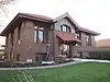 Carnegie Public Library |
May 7, 1980 (#80003717) |
524 4th St. 44°18′32″N 96°47′43″W |
Brookings | |
| 8 | Chicago and Northwestern Railroad Depot | 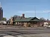 Chicago and Northwestern Railroad Depot |
October 8, 1976 (#76001716) |
Main St. 44°18′25″N 96°47′57″W |
Brookings | |
| 9 | Ivan Cobel House | 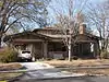 Ivan Cobel House |
August 14, 2003 (#03000762) |
727 Main Ave. 44°18′47″N 96°47′56″W |
Brookings | |
| 10 | Coolidge Sylvan Theatre | 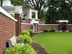 Coolidge Sylvan Theatre |
February 26, 1987 (#87000224) |
Medary Ave. 44°18′59″N 96°47′13″W |
Brookings | |
| 11 | Coughlin Campanile | 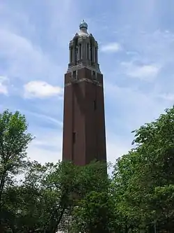 Coughlin Campanile |
February 26, 1987 (#87000223) |
Medary Ave. 44°18′57″N 96°47′16″W |
Brookings | |
| 12 | Experimental Rammed Earth Machine Shed | Experimental Rammed Earth Machine Shed |
August 26, 1993 (#93000869) |
Northwestern corner of the South Dakota State University campus 44°19′14″N 96°47′24″W |
Brookings | |
| 13 | Experimental Rammed Earth Wall | Experimental Rammed Earth Wall |
June 28, 1991 (#91000850) |
Medary Ave. behind Dean of Agricultural and Biological Sciences House on the South Dakota State University campus 44°19′17″N 96°47′21″W |
Brookings | |
| 14 | Fishback House | 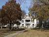 Fishback House |
October 8, 1976 (#76001717) |
501 8th St. 44°18′52″N 96°47′47″W |
Brookings | |
| 15 | Graham House | 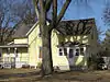 Graham House |
June 3, 1994 (#94000559) |
927 7th St. 44°19′39″N 96°47′33″W |
Brookings | |
| 16 | John L. Hall House | 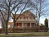 John L. Hall House |
November 29, 2010 (#10000955) |
121 Samara Ave. 44°19′28″N 96°55′42″W |
Volga | |
| 17 | E. E. Haugen House | 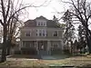 E. E. Haugen House |
March 1, 2010 (#10000047) |
202 5th St. 44°18′37″N 96°48′07″W |
Brookings | |
| 18 | Henry-Martinson House | 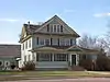 Henry-Martinson House |
December 20, 1977 (#77001237) |
405 Kasan Ave. 44°19′16″N 96°55′36″W |
Volga | |
| 19 | Intermill House | May 9, 1997 (#97000427) |
46408 203rd St. 44°26′36″N 96°55′30″W |
Bruce | ||
| 20 | Lockhart House | 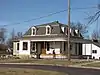 Lockhart House |
November 29, 2010 (#10000954) |
1001 6th Ave. 44°19′01″N 96°47′43″W |
Brookings | |
| 21 | G. A. Mathews House | November 26, 1986 (#86002989) |
423 Eighth St. 44°18′53″N 96°47′50″W |
Brookings | ||
| 22 | Herman F. Micheel Gothic Arched-Roof Barn | 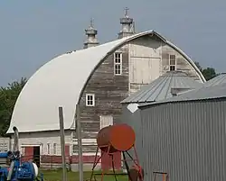 Herman F. Micheel Gothic Arched-Roof Barn |
January 25, 1991 (#90002207) |
5 miles north and 3 miles west of White 44°30′35″N 96°42′28″W |
White | |
| 23 | Mortimer Cabin | October 26, 2017 (#100001397) |
20247 Oakwood Shoreline Dr. 44°25′51″N 96°59′44″W |
Bruce | ||
| 24 | Nick's Hamburger Shop | 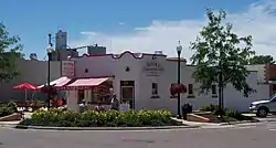 Nick's Hamburger Shop |
November 6, 1986 (#86003008) |
427 Main Ave. 44°18′36″N 96°47′56″W |
Brookings | |
| 25 | Pioneer Park Bandshell | 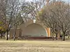 Pioneer Park Bandshell |
November 19, 2007 (#07001208) |
Southwestern corner of the junction of U.S. Route 14 and 1st Ave. 44°18′46″N 96°48′18″W |
Brookings | |
| 26 | St. Mary's School | 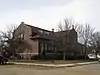 St. Mary's School |
October 24, 1996 (#96001228) |
220 E. 3rd St. 44°14′05″N 96°28′47″W |
Elkton | |
| 27 | Sexauer Seed Company Historic District | 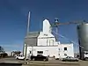 Sexauer Seed Company Historic District |
November 8, 2001 (#01001225) |
Roughly bounded by Main Ave., the Dakota, Minnesota and Eastern railroad tracks, 2nd St., and 6th Ave. 44°18′21″N 96°47′50″W |
Brookings | |
| 28 | George P. Sexauer House | 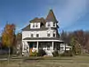 George P. Sexauer House |
January 26, 1990 (#89002333) |
929 4th St. 44°18′33″N 96°47′18″W |
Brookings | |
| 29 | Singsaas Lutheran Church | 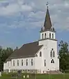 Singsaas Lutheran Church |
October 23, 2003 (#03001070) |
19715 487th Ave.[6] 44°31′34″N 96°27′54″W |
Lake Hendricks Township | |
| 30 | South Dakota Department of Transportation Bridge No. 06-129-020 | November 30, 1999 (#99001433) |
Local road over the Big Sioux River 44°30′53″N 96°52′11″W |
Bruce | Destroyed in 2011 | |
| 31 | South Dakota Department of Transportation Bridge No. 06-142-190 | 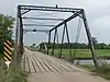 South Dakota Department of Transportation Bridge No. 06-142-190 |
November 30, 1999 (#99001431) |
Local road over the Big Sioux River 44°16′06″N 96°50′35″W |
Brookings | |
| 32 | Sterling Methodist Church | _from_SW_1.jpg.webp) Sterling Methodist Church |
October 19, 1989 (#89001723) |
20200 471st Ave[7] 44°27′21″N 96°47′13″W |
Bruce | |
| 33 | Stock Judging Pavilion | 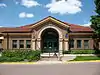 Stock Judging Pavilion |
October 19, 1978 (#78002538) |
11th St. and Medary Ave. on the South Dakota State University campus 44°19′08″N 96°47′18″W |
Brookings | |
| 34 | Trygstad Law and Commerce Building | 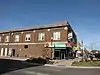 Trygstad Law and Commerce Building |
February 23, 1984 (#84003244) |
401 Main Ave. 44°18′33″N 96°47′54″W |
Brookings | |
| 35 | Volga Auditorium | 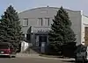 Volga Auditorium |
July 5, 2000 (#00000723) |
212 Kasan Ave. 44°19′30″N 96°55′35″W |
Volga | |
| 36 | Vostad Farm | 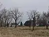 Vostad Farm |
April 14, 2005 (#05000283) |
2905 16th Ave., W. 44°20′30″N 96°49′46″W |
Brookings | |
| 37 | Solomon Walters House | 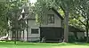 Solomon Walters House |
April 26, 1978 (#78002539) |
Railway St. 44°26′08″N 96°53′27″W |
Bruce | |
| 38 | Wenona Hall and Wecota Hall | 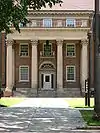 Wenona Hall and Wecota Hall |
May 7, 1980 (#80003718) |
Medary Ave. 44°19′04″N 96°47′20″W |
Brookings | |
| 39 | Woodbine Cottage | 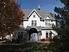 Woodbine Cottage |
January 26, 1990 (#89002332) |
929 Harvey Dunn St. 44°19′05″N 96°47′18″W |
Brookings | |
| 40 | Woodbine Cottage Experimental Rammed Earth Wall | 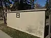 Woodbine Cottage Experimental Rammed Earth Wall |
June 28, 1991 (#91000849) |
West of the junction of 10th St. and Medary Ave. on the South Dakota State University campus 44°19′01″N 96°47′19″W |
Brookings |
Former listing
| [3] | Name on the Register | Image | Date listed | Date removed | Location | City or town | Summary |
|---|---|---|---|---|---|---|---|
| 1 | William H. and Elizabeth Beals House | June 9, 1992 (#92000685) | March 26, 2008 | 1302 Sixth Street |
Brookings | ||
| 2 | Farmers Store | August 7, 1979 (#78002537) | February 23, 1988 | Main St. |
Brookings | ||
| 3 | SDSU Extension Building | March 21, 1978 (#78002537) | December 27, 1989 | Rotunda Lane |
Brookings | ||
| 4 | South Dakota Department of Transportation Bridge No. 06-131-040 | November 30, 1999 (#99001432) | March 26, 2008 | Local Rd. over Big Sioux R. |
Brookings |
See also
| Wikimedia Commons has media related to National Register of Historic Places in Brookings County, South Dakota. |
References
- The latitude and longitude information provided in this table was derived originally from the National Register Information System, which has been found to be fairly accurate for about 99% of listings. Some locations in this table may have been corrected to current GPS standards.
- "National Register of Historic Places: Weekly List Actions". National Park Service, United States Department of the Interior. Retrieved on January 29, 2021.
- Numbers represent an alphabetical ordering by significant words. Various colorings, defined here, differentiate National Historic Landmarks and historic districts from other NRHP buildings, structures, sites or objects.
- "National Register Information System". National Register of Historic Places. National Park Service. April 24, 2008.
- The eight-digit number below each date is the number assigned to each location in the National Register Information System database, which can be viewed by clicking the number.
- The NRHP nominating form gives the address as "19716". However, a 2017 photo shows an address marker for 19715, which address is also given at "Singaas Free Lutheran Church", Association of Free Lutheran Congregations, retrieved September 23, 2017.
- "The AWSUM Churches". Aurora-White-Sterling UMC. Retrieved September 22, 2017.
| Topics | |
|---|---|
| Lists by state |
|
| Lists by insular areas | |
| Lists by associated state | |
| Other areas | |
| Related | |
| |
Municipalities and communities of Brookings County, South Dakota, United States | ||
|---|---|---|
| Cities | | |
| Towns | ||
| CDP | ||
| Other unincorporated communities | ||
| Townships |
| |
| Footnotes | ‡This populated place also has portions in an adjacent county or counties | |
| ||
This article is issued from Wikipedia. The text is licensed under Creative Commons - Attribution - Sharealike. Additional terms may apply for the media files.