National Register of Historic Places listings in Kingsbury County, South Dakota
This is a list of the National Register of Historic Places listings in Kingsbury County, South Dakota.
Location of Kingsbury County in South Dakota
This is intended to be a complete list of the properties and districts on the National Register of Historic Places in Kingsbury County, South Dakota, United States. The locations of National Register properties and districts for which the latitude and longitude coordinates are included below, may be seen in a map.[1]
There are 22 properties and districts listed on the National Register in the county.
- This National Park Service list is complete through NPS recent listings posted January 29, 2021.[2]
Current listings
| [3] | Name on the Register[4] | Image | Date listed[5] | Location | City or town | Description |
|---|---|---|---|---|---|---|
| 1 | Arlington Masonic Temple | 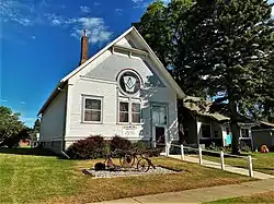 Arlington Masonic Temple |
February 27, 2017 (#100000690) |
222 S. Main St. 44°21′47″N 97°08′06″W |
Arlington | |
| 2 | Badger School District Number 18 | August 2, 2006 (#06000665) |
Junction of Main St. and 1st Ave. 44°29′12″N 97°12′30″W |
Badger | ||
| 3 | Bank of the Iroquois Building | May 30, 2002 (#02000576) |
Junction of Washita and Quapaw Sts. 44°22′01″N 97°51′01″W |
Iroquois | ||
| 4 | Berger Farmstead | March 15, 2005 (#05000179) |
19802 446th Ave. 44°30′54″N 97°17′20″W |
Badger | ||
| 5 | Central Dakota Flouring Mill Grain Elevator | 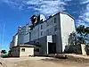 Central Dakota Flouring Mill Grain Elevator |
May 30, 2002 (#02000573) |
202 E. Elm St. 44°21′47″N 97°07′50″W |
Arlington | |
| 6 | Chicago Northwestern Depot | 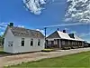 Chicago Northwestern Depot |
December 12, 1976 (#76001739) |
Highway 25 44°23′09″N 97°32′50″W |
De Smet | |
| 7 | Esmond Methodist Episcopal Church and Township Hall | August 2, 2006 (#06000666) |
Junction of Center St. and Elm St. 44°15′53″N 97°46′19″W |
Esmond | ||
| 8 | Hetland School | May 30, 2002 (#02000572) |
Park St. 44°22′43″N 97°14′11″W |
Hetland | ||
| 9 | Ingalls House | 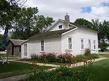 Ingalls House |
April 21, 1975 (#75001717) |
210 3rd St., W. 44°23′07″N 97°33′17″W |
De Smet | |
| 10 | Kingsbury County Courthouse | 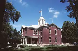 Kingsbury County Courthouse |
September 22, 1977 (#77001249) |
Highway 25 44°23′10″N 97°32′41″W |
De Smet | |
| 11 | Lake Preston High School | 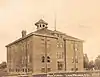 Lake Preston High School |
October 24, 2003 (#03001074) |
300 First Street, N.E. 44°21′48″N 97°22′24″W |
Lake Preston | |
| 12 | Lake Preston Tourist Park Historic District | May 30, 2002 (#02000574) |
Junction of U.S. Route 14 and S. Park Ave. 44°21′36″N 97°22′07″W |
Lake Preston | ||
| 13 | Oldham Methodist Church | September 25, 1987 (#87001728) |
Main St. and Epton Ave. 44°13′41″N 97°18′40″W |
Oldham | ||
| 14 | Omdalen Barn | August 2, 2006 (#06000667) |
44750 209th St. 44°21′22″N 97°15′38″W |
Lake Preston | ||
| 15 | Peterson-Loriks House | June 19, 1980 (#80003726) |
In Oldham 44°13′48″N 97°18′30″W |
Oldham | ||
| 16 | Railroad Camp Shanty | 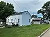 Railroad Camp Shanty |
March 20, 1973 (#73001744) |
1st and Olivet Sts. 44°23′12″N 97°32′38″W |
De Smet | |
| 17 | Adam and Minnie Royhl House | 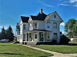 Adam and Minnie Royhl House |
June 6, 2001 (#01000638) |
203 S. 3rd St. 44°21′47″N 97°08′12″W |
Arlington | |
| 18 | Thomas H. Ruth House | 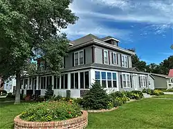 Thomas H. Ruth House |
February 12, 1999 (#99000212) |
209 Poinset Ave. 44°23′03″N 97°33′05″W |
De Smet | |
| 19 | Shady Lawn School No. 8 | June 26, 2019 (#100004125) |
42893 198th St. 44°30′49″N 97°38′02″W |
De Smet | ||
| 20 | South Dakota Dept. of Transportation Bridge No. 39-006-070 | December 9, 1993 (#93001297) |
Local road over Pearl Creek 44°26′27″N 97°50′26″W |
Iroquois | ||
| 21 | Stark and Blanch Garage | 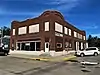 Stark and Blanch Garage |
November 19, 2007 (#07001212) |
204 S. Main 44°21′56″N 97°08′06″W |
Arlington | |
| 22 | Olaf Stordahl Barn | May 30, 2002 (#02000575) |
45210 199th St. 44°30′15″N 97°09′52″W |
Arlington |
Former listings
| [3] | Name on the Register | Image | Date listed | Date removed | Location | City or town | Summary |
|---|---|---|---|---|---|---|---|
| 1 | Esmond Bridge | December 9, 1993 (#93001298) | December 15, 1999 | Local rd. over Redstone Cr. |
De Smet vicinity | ||
| 2 | South Dakota Dept. of Transportation Bridge No. 39-176-100 | December 9, 1993 (#93001299) | December 15, 1999 | Local rd. over unnamed cr. |
De Smet vicinity |
See also
| Wikimedia Commons has media related to National Register of Historic Places in Kingsbury County, South Dakota. |
References
- The latitude and longitude information provided in this table was derived originally from the National Register Information System, which has been found to be fairly accurate for about 99% of listings. Some locations in this table may have been corrected to current GPS standards.
- "National Register of Historic Places: Weekly List Actions". National Park Service, United States Department of the Interior. Retrieved on January 29, 2021.
- Numbers represent an alphabetical ordering by significant words. Various colorings, defined here, differentiate National Historic Landmarks and historic districts from other NRHP buildings, structures, sites or objects.
- "National Register Information System". National Register of Historic Places. National Park Service. April 24, 2008.
- The eight-digit number below each date is the number assigned to each location in the National Register Information System database, which can be viewed by clicking the number.
| Topics | |
|---|---|
| Lists by state |
|
| Lists by insular areas | |
| Lists by associated state | |
| Other areas | |
| Related | |
| |
Municipalities and communities of Kingsbury County, South Dakota, United States | ||
|---|---|---|
| Cities | | |
| Towns | ||
| Unincorporated communities | ||
| Ghost town | ||
| Footnotes | ‡This populated place also has portions in an adjacent county or counties | |
| ||
This article is issued from Wikipedia. The text is licensed under Creative Commons - Attribution - Sharealike. Additional terms may apply for the media files.