Nebraska Highway 31
Nebraska Highway 31 is a highway in Nebraska. The southern terminus is near Louisville at an intersection with Nebraska Highway 50. The northern terminus is near Kennard at an intersection with U.S. Highway 30. The highway serves as a main north–south highway in the western portion of the Omaha Metro Area.
| ||||
|---|---|---|---|---|
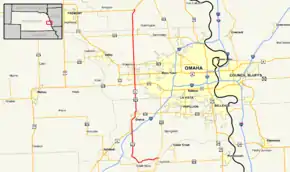 Nebraska Highway 31 highlighted in red | ||||
| Route information | ||||
| Maintained by NDOT | ||||
| Length | 36.33 mi[1] (58.47 km) | |||
| Existed | 1925[2]–present | |||
| Major junctions | ||||
| South end | ||||
| North end | ||||
| Location | ||||
| Counties | Sarpy, Douglas, Washington | |||
| Highway system | ||||
| ||||

Route description
Nebraska Highway 31 begins just north of Louisville at Nebraska Highway 50. It goes west on an alignment which lies just north of the Platte River. After five and a half miles, NE 31 comes to the entrance of Schramm Park State Recreation Area, after which, it turns north. Just south of Interstate 80, NE 31 becomes a divided highway. After crossing I-80, NE 31 meets U.S. Highway 6 and the two highways begin an overlap.[1][3]
NE 31 and US 6 continue north into Gretna, where the divided highway ends. At Gretna, NE 31 and US 6 meet Nebraska Highway 370. They continue north and become divided highway again. Near the Elkhorn neighborhood of Omaha, NE 31 and US 6 meet U.S. Highway 275 and Nebraska Highway 92, which is West Center Road. Two miles later, they separate at an intersection in which they also meet Nebraska Link 28B, which is West Dodge Road.[1][3]
NE 31 continues through Elkhorn, and then meets Nebraska Highway 64. It continues north and then meets Nebraska Highway 36 and ends at an intersection southwest of Kennard with U.S. Highway 30.[1][3]
Major intersections
| County | Location | mi[1] | km | Destinations | Notes |
|---|---|---|---|---|---|
| Sarpy | | 0.00 | 0.00 | Southern terminus | |
| 11.04 | 17.77 | I-80 exit 432 | |||
| 11.39 | 18.33 | South end of US 6 overlap | |||
| Gretna | 14.97 | 24.09 | Western terminus of N-370 | ||
| Douglas | Omaha | 21.04 | 33.86 | Interchange | |
| 23.04 | 37.08 | Interchange; eastern terminus of L-28B; north end of US 6 overlap | |||
| 25.05 | 40.31 | ||||
| | 31.04 | 49.95 | |||
| Washington | Kennard | 36.33 | 58.47 | Northern terminus | |
1.000 mi = 1.609 km; 1.000 km = 0.621 mi
| |||||
Points of interest
- Schramm Park State Recreation Area
- Nebraska Crossing Factory Outlet
References
- "Nebraska Highway Reference Log Book" (PDF). Nebraska Department of Roads. 2015. pp. 109–110. Retrieved January 7, 2017.
- Nebraska Roads: NE 21-40
- Google (2010-11-08). "overview of Nebraska Highway 31" (Map). Google Maps. Google. Retrieved 2010-11-08.
