Niya County
Niya County[4][5][6] (transliterated from the Uyghur نىيە ناھىيىسى Niyă Nahiyisi ; simplified Chinese: 尼雅县; traditional Chinese: 尼雅縣; pinyin: Níyǎ Xiàn), also from Mandarin Chinese as Minfeng County (simplified Chinese: 民丰县; traditional Chinese: 民豐縣; pinyin: Mínfēng Xiàn), is a county within the Xinjiang Uyghur Autonomous Region and is under the administration of the Hotan Prefecture. It contains an area of 56,726 km2 (21,902 sq mi). According to the 2002 census, it has a population of 30,000.[7] The county is bordered to the north by Xayar County, to the east by Qiemo/Qarqan County, to the west by Yutian / Keriya County and to the south by Ngari Prefecture in Tibet.
Niya County
نىيە ناھىيىسى 民丰县 Minfeng | |
|---|---|
 | |
.png.webp) Minfeng County (red) in Hotan Prefecture (yellow) and Xinjiang | |
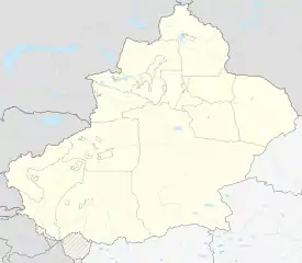 Minfeng Location of the seat in Xinjiang | |
| Coordinates: 37°04′N 82°46′E | |
| Country | People's Republic of China |
| Autonomous region | Xinjiang |
| Prefecture | Hotan Prefecture |
| County seat | Niya |
| Area | |
| • Total | 56,759.86 km2 (21,915.10 sq mi) |
| Population (2010)[1] | |
| • Total | 33,932 |
| • Density | 0.60/km2 (1.5/sq mi) |
| Ethnic groups | |
| • Major ethnic groups | Uyghur[3] |
| Time zone | UTC+8 (China Standard) |
| Postal code | 848500 |
| Website | www |
| Niya County | |||||||||||
|---|---|---|---|---|---|---|---|---|---|---|---|
| Uyghur name | |||||||||||
| Uyghur | نىيە ناھىيىسى | ||||||||||
| |||||||||||
| Chinese name | |||||||||||
| Simplified Chinese | 民丰县 | ||||||||||
| Traditional Chinese | 民豐縣 | ||||||||||
| |||||||||||
| Alternative Chinese name | |||||||||||
| Simplified Chinese | 尼雅县 | ||||||||||
| Traditional Chinese | 尼雅縣 | ||||||||||
| |||||||||||
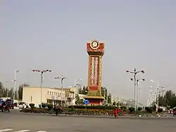
The county seat is in the town of Niya, which is often referred to by the county name (Minfeng) as well. The Niya ruins are located 115 km north of Niya.
History
In the early 20th century, Aurel Stein carried out several expeditions in the area including exploration of the ancient Niya ruins.
In 1945, Minfeng Shezhiju (民豐設治局) was established. In 1947, the area became Minfeng County.[2]
In 2012, the township of Yawatongguz (Yawatongguzi) was established.[1][8]
In early 2015, a joint report issued by the Water Conservancy Office of Hotan prefecture and the regional Water Conservancy Department reported that up to 80 percent of the population of the county did not have access to clean drinking water.[9]
In June 2015 in the lead-up to Ramadan, a beer festival was held in the county leading to condemnation from Dilxat Raxit, spokesman for the World Uyghur Congress.[6]
In September 2015, residents of the county were reported to be subject to new rules concerning unacceptable given names for Uyghur children.[10]
On December 8, 2019, County Communist Party Committee Vice Secretary (委副书记) and County Magistrate (县长) Aizezi Aili (艾则孜·艾力) penned a criticism of the Uyghur Human Rights Policy Act.[11]
Geography
The northern part of the county is located in the Taklamakan Desert and consists of large areas of sand dunes. The population centers on oases around rivers flowing down from the mountains in the southern part of the county.
Climate
As of 1997, on average, Minfeng experienced blowing dust or sand on 189 days in a year and visibility below 4,800 meters for more than half of winter and summer as well as for thirty to forty percent of spring. The lowest spring time temperature recorded in Minfeng was -22 Celsius.[12]
Administrative divisions
The county includes one town and six townships:[1][13][14]
Town:
Townships:
- Niya (Niye; نىيە يېزىسى Niyă Yezisi / 尼雅乡), Rokiya (Ruokeya, Rukiya; رۇكىيا يېزىسى Rukiya Yezisi / 若克雅乡), Salgozak (Salewuzeke, Salghozek; سالغوزەك يېزىسى[15] Salghuzăk Yezisi / 萨勒吾则克乡), Yeyik (Yeyike, Yëyiq, Ya-li-ka, Yeh-i-k'o; يېيىق يېزىسى Yeyiq Yezisi / 叶亦克乡), Andir (Andi'er, Endir; ئەندىر يېزىسى[16] Ăndir Yezisi / 安迪尔乡, area of Andirlangar), Yawatongguz (Yawatongguzi, Yawa Tongguz; ياۋا توڭگۇز يېزىسى Yawa Tongguz Yezisi / 亚瓦通古孜乡, area of Yawatongguzlangar[17])
Economy
The economy is primarily based on agriculture and livestock farming. Products of the county include corn, wheat, cotton and sheep wool. Industries in the county include electronics, agriculture technology, food processing, carpets and construction.[2]
Demographics
As of 2015, 34,900 of the 38,492 residents of the county were Uyghur, 3,509 were Han Chinese and 83 were from other ethnic groups.[18]
As of 1999, 90.94% of the population of Niya (Minfeng) County was Uyghur and 8.91% of the population was Han Chinese.[19]
Transportation
Gallery
_(14596524608).jpg.webp) Niya men (1912)
Niya men (1912)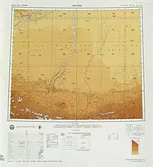 Map including Minfeng (labeled as MIN-FENG (NIYA BAZAR)) and surrounding region in the International Map of the World (ATC, 1971)
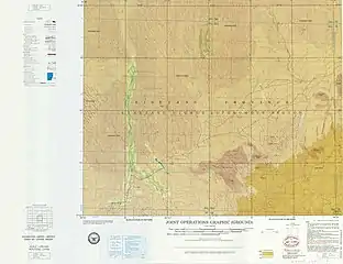 Map including Niya (labeled as MIN-FENG (NI-YA)) (ATC, 1971)
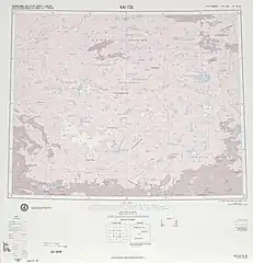 Map including the southern part of Minfeng/Niya County and the county's border with Tibet (DMA, 1975)
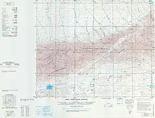 Map including part of Niya (Minfeng) County (DMA, 1979)
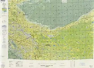 Map including Minfeng (labeled as Minfeng (Min-feng)) and surrounding region (DMA, 1980)[lower-alpha 1]
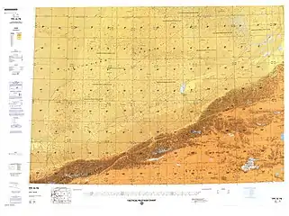 Map including Niya (labeled as Minfeng) (DMA, 1990)
 Statue of Mao Zedong (Mao Tse-tung) and a Uyghur farmer
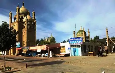 Mosques in Niya
Notes
- From map: "The representation of international boundaries is not necessarily authoritative."
References
- 民丰县历史沿革 [Minfeng County Historical Development] (in Chinese). XZQH.org. 2 December 2014. Retrieved 8 December 2019.
2003年,民丰县总面积56759.86平方千米,{...}2010年第六次人口普查,民丰县常住总人口33932人,其中:尼雅镇3486人,尼雅乡6373人,若克雅乡6895人,萨勒吾则克乡4195人,叶亦克乡3751人,安迪尔乡343人,安迪尔牧场2165人,城镇街道6724人。 2012年,设立亚瓦通古孜乡,乡政府驻亚瓦通古孜村(新政函[2012]90号)。调整后,全县辖1个镇、6个乡:尼雅镇、尼雅乡、若克雅乡、萨勒吾则克乡、叶亦克乡、安迪尔乡、亚瓦通古孜乡。
- 夏征农; 陈至立, eds. (September 2009). 辞海:第六版彩图本 [Cihai (Sixth Edition in Color)] (in Chinese). 上海. Shanghai: 上海辞书出版社. Shanghai Lexicographical Publishing House. p. 1580. ISBN 9787532628599.
面积5.67万平方千米。{...}1945年由和阗县(今和田县)析置民丰设治局,1947年改民丰县。经济以农、牧业为主,产玉米、小麦、棉花和羊毛。工业有电力、农机修造、食品加工、地毯、建材等。
- 1997年民丰县行政区划. XZQH.org (in Chinese). 6 January 2011. Retrieved 24 March 2020.
其中维吾尔族占91%,辖1镇、5乡。
- Ministry of Housing and Urban-Rural Development (2010). 建筑抗震设计规范 [GB50011-2010: Code for Seismic Design of Buildings] (in English and Chinese). Beijing: China Architecture & Building Press. p. 203 – via Google Books.
Niya County
- "'Many Uygurs like to drink': Chinese academic defends beer festival in Muslim region". South China Morning Post. 24 June 2015. Retrieved 24 March 2020.
Xinjiang's government-run Tianshan website showed that officials in Niya county organised an event where local Muslims made and ate rice dumplings on Saturday, three days after the start of Ramadan, during which devout Muslims abstain from all food and drink during daylight hours.
- Ben Blanchard (22 June 2015). Paul Tait (ed.). "Exiles angered as China holds beer festival in Muslim county". Reuters. Retrieved 9 December 2019.
The beer festival happened in a village in Niya County in the deep south of Xinjiang, which is overwhelmingly populated by the Muslim Uighur people who call Xinjiang home. Muslims are not meant to consume alcohol, according to the Koran. The Niya government website said the “beer competition”, which happened last Monday just before the start of Ramadan, was attended by more than 60 young farmers and herders.
- The Silk Road - China and the Karakorum Highway: A Travel Companion 1780763565 Jonathan Tucker - 2015 - Niya, north of Minfeng, Xinjiang province (photograph by Antonia Tozer) Wooden tablet written in Kharosthi (Spink and Son Ltd.) The Shanpula cemetery, Luopu county, near Khotan, Xinjiang province (photograph by Antonia Tozer) Remains.
- 2012年统计用区划代码和城乡划分代码:民丰县 [2012 Statistical Area Numbers and Rural-Urban Area Numbers: Minfeng County] (in Chinese). National Bureau of Statistics of the People's Republic of China. 2012. Retrieved 14 January 2020.
代码 名称 653227100000 尼雅镇 653227200000 尼雅乡 653227201000 若克雅乡 653227202000 萨勒吾则克乡 653227203000 叶亦克乡 653227204000 亚瓦通古孜乡 653227205000 安迪尔乡
- Joshua Lipes; reporter Jilil Kashgary (4 February 2015). "More Than One Million Lack Clean Water in Xinjiang's Hotan Prefecture". Radio Free Asia. Translated by Mamatjan Juma. Retrieved 11 December 2019.
- Roseanne Gerin; reporter Eset Sulaiman (24 September 2015). Eset Sulaiman (ed.). "Chinese Authorities Ban Muslim Names Among Uyghurs in Hotan". Retrieved 11 December 2019.
A Uyghur woman named Turakhan who lives in a suburban village of Niya (in Chinese, Minfeng) county in Hotan (Hetian) prefecture told RFA’s Uyghur Service on Wednesday that the village chief and police had informed all residents about “the list of forbidden Muslim names.” “My daughter’s name is Muslime, so the village police came to our house and told us that we must change our daughter’s name as soon as possible,” she said. “The police explained to us that a name such as Muslime was officially forbidden. Under such circumstances, we were forced to change our daughter’s name.” The police also told Turakhan: "It is the decision of the township and village authorities. Don’t ask any foolish questions.” Turakhan later found out that authorities were forbidding children whose parents did not change their names from attending kindergarten and elementary school, she said.
- 艾则孜·艾力 (8 December 2019). 李梦婷 (ed.). 坚决不允许美国蓄意诋毁和抹黑新疆的人权状况. Xinhua News Agency (in Chinese). Retrieved 8 December 2019.
- MSgt Donald E. Carey; Melody L. Higdon; Robert S. Lilianstrom; MSgt Charles D. Surls (September 1997). "East Asia A Climatological Study". Air Force Combat Climatology Center. pp. 4–7, 4–11, 4–29, 4–44 – via Internet Archive.
- 2018年统计用区划代码和城乡划分代码:民丰县 [2018 Statistical Area Numbers and Rural-Urban Area Numbers: Minfeng County] (in Chinese). National Bureau of Statistics of the People's Republic of China. 2018. Retrieved 8 December 2019.
统计用区划代码 名称 653227100000 尼雅镇 653227200000 尼雅乡 653227201000 若克雅乡 653227202000 萨勒吾则克乡 653227203000 叶亦克乡 653227204000 安迪尔乡 653227205000 亚瓦通古孜乡
- "Archived copy" 首页. 尼雅网-民丰县政府门户网站 (in Chinese). Archived from the original on 23 April 2018. Retrieved 19 April 2020.
乡镇 尼雅乡 尼雅镇 若克雅乡 叶亦克乡 萨勒吾则克乡 亚瓦通古孜乡 安迪尔乡 街道办事处
CS1 maint: archived copy as title (link) - سالغوزەك (Variant Non-Roman Script - VS) at GEOnet Names Server, United States National Geospatial-Intelligence Agency
- ئابدۇسالام ئابلىز, ed. (24 December 2019). پەن - تېخنىكا ئارقىلىق نامراتلارنى دەل جايىدا يۆلەش كەنت ئاھالىلىرىنىڭ كىرىمىنى ئاشۇرۇپ بېيىتتى. 阿克苏新闻网-维文版 (in Uyghur). Retrieved 13 May 2020.
نىيە ناھىيەسى ئەندىر يېزىسى
- Webster's 21st Century World Atlas. Barnes & Noble Books. 1999. p. 83 – via Internet Archive.
Yawatongguzlangar{...}Yeyik
- 3-7 各地、州、市、县(市)分民族人口数 (in Chinese). شىنجاڭ ئۇيغۇر ئاپتونوم رايونى 新疆维吾尔自治区统计局 Statistic Bureau of Xinjiang Uygur Autonomous Region. 15 March 2017. Archived from the original on 11 October 2017. Retrieved 3 September 2017.
- Morris Rossabi, ed. (2004). Governing China's Multiethnic Frontiers (PDF). University of Washington Press. p. 180. ISBN 0-295-98390-6.
External links
| Wikimedia Commons has media related to Minfeng County. |
| Look up Niya, Minfeng, or Min-feng in Wiktionary, the free dictionary. |
- 《农广天地》昆仑山下鸡羊鲜 20190218 | CCTV农业 (in Chinese)
| Authority control |
|---|