Shule County
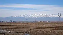
Shule County as the official romanized name, also transliterated from Uyghur as Kaxgar Yengixahar County or shorten as Yengixahar County,[4] is a county situated in the Xinjiang Uyghur Autonomous Region and is under the administrative jurisdiction of the Kashgar Prefecture. It is located to the South of Kashgar City. In Ancient times, the Shule area was once the home to a Xiyu oasis civilisation, the Shule Kingdom.
Shule County
疏勒县 • يېڭىشەھەر ناھىيىسى Yengixahar, Shu-le, Su-le, Su-lo | |
|---|---|
 | |
.png.webp) Location of Shule County (red) within Kashgar Prefecture (yellow) and Xinjiang | |
| Country | People's Republic of China |
| Autonomous region | Xinjiang |
| Prefecture | Kashgar |
| Area | |
| • Total | 2,394 km2 (924 sq mi) |
| Population (2020)[2] | |
| • Total | 312,455 |
| • Density | 130/km2 (340/sq mi) |
| Ethnic groups | |
| • Major ethnic groups | Uyghur[3] |
| Time zone | UTC+8 (China Standard) |
| Postal code | 844200 |
| Website | shule |
| Shule County | |||||||||||
|---|---|---|---|---|---|---|---|---|---|---|---|
| Chinese name | |||||||||||
| Simplified Chinese | 疏勒县 | ||||||||||
| Traditional Chinese | 疏勒縣 | ||||||||||
| |||||||||||
| Alternative Chinese name | |||||||||||
| Simplified Chinese | 英纳协海尔县 | ||||||||||
| Traditional Chinese | 英納協海爾縣 | ||||||||||
| |||||||||||
| Second alternative Chinese name | |||||||||||
| Simplified Chinese | 喀什噶尔英纳协海尔县 | ||||||||||
| Traditional Chinese | 喀什噶爾英納協海爾縣 | ||||||||||
| |||||||||||
| Uyghur name | |||||||||||
| Uyghur | قەشقەر يېڭىشەھەر ناھىيىسى | ||||||||||
| Literal meaning | Kashgar New Town County | ||||||||||
| |||||||||||
History
On May 31, 2012, Sidik Kurban was sentenced by Shule County Intermediate People’s Court to fifteen years in jail and five years deprivation of political rights for 'inciting ethnic separatism' related to involvement in 'illegal religious activities'. For a decade, he had overseen home-based religious schools for eighty-six students.[5]
Administrative divisions

Towns (بازىرى / 镇)
- Yengisheher Town (Shule; يېڭىشەھەر بازىرى[7][8] / 疏勒镇, 英协海尔镇), Hanerik (Hannanlike; خانئېرىق بازىرى[8] / 罕南力克镇), Yapchan (Yafuquan; ياپچان بازىرى[8] / 牙甫泉镇)
Townships (يېزىسى / 乡)
- Barin Township (Baren; بارىن يېزىسى[8] / 巴仁乡), Yanduma Township (Yandaman; ياندۇما يېزىسى / 洋大曼乡), Yamanyar Township (Yamanya; يامانيار يېزىسى / 亚曼牙乡), Baghchi Township (Baheqi; باغچى يېزىسى / 巴合齐乡), Tazghun Township (Tazihong; تازغۇن يېزىسى[8] / 塔孜洪乡), Yengierik Township (Ying'erlike; يېڭىئېرىق يېزىسى / 英尔力克乡), Kumusherik Township (Kumuxilike; قۇمۇشئېرىق يېزىسى / 库木西力克乡), Tagharchi Township (Taga'erqi; تاغارچى يېزىسى / 塔尕尔其乡), Ermudun Township (Ai'ermudong; ئەرمۇدۇن يېزىسى / 艾尔木东乡), Aral Township (Alali; ئارال يېزىسى / 阿拉力乡), Harap Township (Alilafu; ھاراپ يېزىسى[8] / 阿拉甫乡), Yengiawat Township (Ying'awati; يېڭىئاۋات يېزىسى / 英阿瓦提乡)
Others
- Linchang (林场)| Liangzhong Farm (良种场) | Zhongchu Farm (种畜场) | Yuanyi Fields (园艺场) | Canzhong Farm (蚕种场) | Shuichan Farm (水产场) | Fengchang 蜂场 | XPCC 41 base (兵团41团)
Demographics
| Year | Pop. | ±% p.a. |
|---|---|---|
| 2000 | 284,853 | — |
| 2010 | 312,455 | +0.93% |
| [2] | ||
As of 2015, 350,301 of the 377,029 residents of the county were Uyghur, 25,709 were Han Chinese and 1,019 were from other ethnic groups.[10]
As of 1999, 93% of the population of Yengixahar (Shule) County was Uyghur and 6.7% of the population was Han Chinese.[11]
Transportation
Shule is served by China National Highway 315 and the Kashgar-Hotan Railway.
Notable persons
- Almikhan Seyit / Alimiha Seiti (ئالمىخان سېيىت / 阿丽米罕·色依提) (in Uighur), claimed to have died at 132 years old
Historical maps
Maps including Shule:
_p61_PLATE19._SINKIANG_(14597194848).jpg.webp) Map including Shule (labeled as Yangishahr) (1917)
Map including Shule (labeled as Yangishahr) (1917) Map including Shule (labeled as SU-LO) from the International Map of the World (AMS, 1966)[lower-alpha 1]
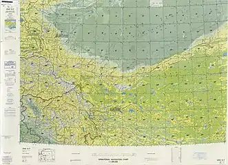
 From the Operational Navigation Chart; map including Shule (labeled as SHULE (SU-LE) (walled)) (DMA, 1980)[lower-alpha 2]
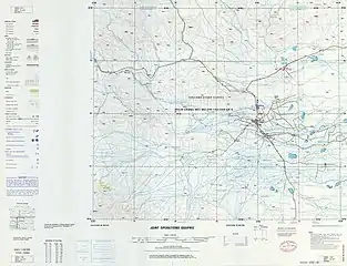
 Map including Shule (Shu-le) (DMA, 1983)
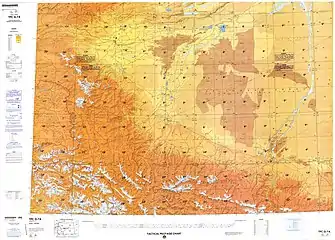
 Map including Shule (labeled as SHULE (SU-LE) (walled)) (DMA, 1984)[lower-alpha 3]
Notes
- From map: "DELINEATION OF INTERNATIONAL BOUNDARIES MUST NOT BE CONSIDERED AUTHORITATIVE"
- From map: "The representation of international boundaries is not necessarily authoritative."
- From map: "The representation of international boundaries is not necessarily authoritative"
References
- 疏勒概况. يېڭىشەھەر 疏勒县政府信息网 (in Chinese). Retrieved 24 March 2020.
疏勒县总面积为2394平方公里,总人口38.22万人,农村人口33.86万人,有维吾尔族、汉族、回族、乌孜别克族、柯尔克孜族、塔吉克族、蒙古族等民族。全县辖3镇12乡、2个农林场、228个行政村、21个社区,耕地面积120万亩。
- 疏勒县历史沿革. XZQH.org. 14 November 2014. Retrieved 24 March 2020.
2000年第五次人口普查,疏勒县常住总人口284853人,{...}2010年第六次人口普查,疏勒县常住总人口312455人,其中:疏勒镇40446人,罕南力克镇24481人,牙甫泉镇25081人,巴仁乡32215人,洋大曼乡17244人,亚曼牙乡15542人,巴合齐乡21865人,塔孜洪乡27393人,英尔力克乡20412人,库木西力克乡20355人,塔合其乡9268人,艾尔木东乡12393人,阿拉力乡11170人,阿拉甫乡18748人,英阿瓦提乡9936人,兵团四十一团5906人。【注:统计部门将"塔尕尔其乡"标为"塔合其乡"】
- 1997年疏勒县行政区划. XZQH.org (in Chinese). 19 November 2010. Retrieved 25 March 2020.
面积2399平方千米,人口26.3万,有维吾尔、汉、柯尔克孜、回、乌孜别克、哈萨克、满、锡伯、塔塔尔、达斡尔、俄罗斯、蒙古、塔吉克等民族,其中维吾尔族占93%,辖3镇12乡,县政府驻疏勒镇。
- Vicky Xiuzhong Xu, Danielle Cave, Dr James Leibold, Kelsey Munro & Nathan Ruser (1 March 2020). "Uyghurs for sale". Australian Strategic Policy Institute. Retrieved 24 March 2020.
The transfer of Uyghur labour to Anhui was part of a ‘Xinjiang Aid’ project organised by the Guangdong government, which also involved HYP setting up a highly secure factory in Xinjiang’s Shule (Yengixahar) county (Figure 11).
CS1 maint: uses authors parameter (link) - "Nine Uyghurs Jailed Over Religious Activities". Radio Free Asia. 6 June 2012. Retrieved 8 April 2020.
The sentences of between six and 15 years were handed down May 31 by three county-level courts in Kashgar prefecture, the exile World Uyghur Congress (WUC) said.{...}In the heaviest of the sentences, the Shule County Intermediate People’s Court sentenced Sidik Kurban to 15 years in jail and five years’ deprivation of political rights on charges of “inciting ethnic separatism” following what it said was his involvement in illegal religious activities. He had overseen the operation of illegal, home-based religious schools throughout Xinjiang over the past decade that provided instruction for 86 students, including young children, the WUC cited a local newspaper as saying.
- 2019年统计用区划代码和城乡划分代码:疏勒县 (in Chinese). National Bureau of Statistics of the People's Republic of China. 2019. Retrieved 24 March 2020.
统计用区划代码 名称 653122100000 疏勒镇 653122101000 罕南力克镇 653122102000 牙甫泉镇 653122200000 巴仁乡 653122201000 洋大曼乡 653122202000 亚曼牙乡 653122203000 巴合齐乡 653122204000 塔孜洪乡 653122205000 英尔力克乡 653122206000 库木西力克乡 653122207000 塔合其乡 653122208000 艾尔木东乡 653122209000 阿拉力乡 653122210000 阿拉甫乡 653122211000 英阿瓦提乡 653122400000 疏勒南疆齐鲁工业园区
- (2015) ي ج د 313- (1) نومۇرلۇق. 新疆疏勒县法院网 (in Uyghur). 23 November 2015. Retrieved 25 March 2020.
جاۋابكار بxx، ئايال، ئۇيغۇر، 1971- يىلى 12- ئاينىڭ 2- كۈنى تۇغۇلغان، تولۇقسىز ئوتتۇرا مەكتەپ مەدەنىيەت سەۋىيەسىگە ئىگە، دېھقان، قوشۇمچە يىڭىشەھەر ناھىيە شەھەر موھىتىنى ئولتۇرۇقى: يېڭىشەھەر ناھىيە يېڭىشەھەر بازىرى سەككىز تاش كەنت 1-مەھەللە 1- كورپۇس، 19- نومۇرلۇق ئۆي، ئىلگىرى جازالانمىغان.
- شەندۇڭ ئۆلكىسى قۇرۇشقا ياردەم بەرگەن «مېھىر-شەپقەت تاللا بازىرى» تۈرى يېڭىشەھەر ناھىيەسىدە يولغا قويۇلدى. جۇڭگو قەشقەر تورى 中国喀什网 (in Uyghur). 28 July 2018. Retrieved 25 March 2020.
نۆۋەتتە، بۇ تۈرنى نۇقتىدا سىناق قىلىش خىزمىتى يېڭىشەھەر ناھىيەسىنىڭ يېڭىشەھەر بازىرى، بارىن يېزىسى، تازغۇن يېزىسى، خانئېرىق بازىرى، ياپچان بازىرى، ھاراپ يېزىسىدىن ئىبارەت ئالتە يېزا (بازار)دا قانات يايدۇرۇلغان.
- Herold J. Wiens (November 1966). "Cultivation Development and Expansion in China's Colonial Realm in Central Asia". The Journal of Asian Studies. 26 (1): 75 – via JSTOR.
- 3-7 各地、州、市、县(市)分民族人口数 (in Chinese). شىنجاڭ ئۇيغۇر ئاپتونوم رايونى 新疆维吾尔自治区统计局 Statistic Bureau of Xinjiang Uygur Autonomous Region. 15 March 2017. Archived from the original on 11 October 2017. Retrieved 3 September 2017.
- Morris Rossabi, ed. (2004). Governing China’s Multiethnic Frontiers (PDF). University of Washington Press. p. 179. ISBN 0-295-98390-6.