Yanqi Hui Autonomous County
Yanqi Hui Autonomous County (Uyghur: Qarasheher, Karashahr) is an autonomous county in the Xinjiang Uyghur Autonomous Region and is under the administration of the Bayin'gholin Mongol Autonomous Prefecture. It has an area of 2,429 km2 (938 sq mi). According to the 2002 census, it has a population of 120,000. The Qigexing Buddhist Temple Ruins are located in Yanqi County, about 25–30 km (16–19 mi) southwest of the town of Yanqi.
Yanqi Hui Autonomous County
焉耆回族自治县 (Chinese) ﻳﯾًﺎ چِ ﺧُﻮِ ذُﻮْ ذِ جِ ﺷِﯿًﺎ (Xiao'erjing) يەنجى خۇيزۇ ئاپتونوم ناھىيىسى (Uighur) Kara Shahr; Yenki | |
|---|---|
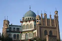 Mosque in the city center of Yanqi | |
.png.webp) Yanqi County (red) within Bayin'gholin Prefecture (yellow) and Xinjiang | |
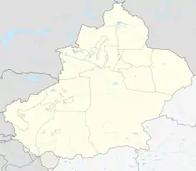 Yanqi Location of the seat in Xinjiang | |
| Coordinates: 42°03′35″N 86°34′27″E | |
| Country | People's Republic of China |
| Autonomous region | Xinjiang |
| Autonomous prefecture | Bayin'gholin Mongol Autonomous Prefecture |
| Time zone | UTC+8 (China Standard) |
| Yanqi Hui Autonomous County | |||||||||||
|---|---|---|---|---|---|---|---|---|---|---|---|
 | |||||||||||
| Chinese name | |||||||||||
| Simplified Chinese | 焉耆回族自治县 | ||||||||||
| Traditional Chinese | 焉耆回族自治縣 | ||||||||||
| |||||||||||
| Uyghur name | |||||||||||
| Uyghur | يەنجى خۇيزۇ ئاپتونوم ناھىيىسى | ||||||||||
| |||||||||||
Administrative division
The autonomous county contains four towns and four townships:
Towns:
- Yanqi Town (焉耆镇; Yānqí Zhèn), consisting of ten residential communities (社区; shèqū) und one village, seat of the county government, 29.000 inhabitants (2000);
- Qigxin (七个星镇; Qīgèxīng Zhèn), one residential community and nine villages, 12.629 inhabitants (2000);
- Yongning (永宁镇; Yŏngníng Zhèn), two residential communities and eight villages, 18.235 inhabitants (2000);
- Sishilichengzi (四十里城子镇; Sìshílǐchéngzi Zhèn), one residential community and five villages, 8.722 inhabitants (2000);
Townships:
- Beidaqu (北大渠乡; Bĕidàqú Xiāng; 'Northern Great Canal Village'), six villages, 9.026 inhabitants (2000);
- Wuhaoqu (五号渠乡; Wŭhàoqú xiāng; 'Fifth Canal Village'), one residential community and nine villages, 14.791 inhabitants (2000);
- Qagan Qehe (查汗采开乡; Cháhàn Cǎikāi Xiāng), four villages, 5.841 inhabitants (2000);
- Borhoi (包尔海乡; Bāoĕrhǎi Xiāng), five villages, 6.614 inhabitants (2000).
In addition, there three state owned operations in the county (2000):
Economy
The county economy is predominately agricultural with 13,000 hectares used to cultivate red pepper.[1] The county is considered the most important area for red pepper production in China.[1] During the red pepper harvest season beginning in September, the county is home to the remarkable sight of drying peppers sitting in the Gobi Desert "as far as the eye can see".[1]
As of 1885, there was about 25,300 acres (167,805 mu) of cultivated land in Kara Shahr.[2]
See also
References
- "Yanqi Hui county starts 13000 hectare red pepper bumper harvest". China News Xinjiang. September 19, 2017.
- Herold J. Wiens (November 1966). "Cultivation Development and Expansion in China's Colonial Realm in Central Asia". The Journal of Asian Studies. 26 (1): 75 – via JSTOR.
| Authority control |
|---|