Uqturpan County
Uqturpan County[5][6][7] or Uchturpan County[8][9][10] (transliterated from Uighur: ئۇچتۇرپان ناھىيىسى; Chinese: 乌什吐鲁番县), also Wushi County (Chinese: 乌什县), is a county in the Xinjiang Uyghur Autonomous Region under the administration of Aksu Prefecture and shares an approximately 150 km (93 mi)[2] long border with Kyrgyzstan's Issyk-Kul Region. The county is bordered to the northeast by Onsu County (Wensu), to the southeast by Aksu city, to the west by Akqi County in Kizilsu Kyrgyz Autonomous Prefecture and to the south by Kalpin County (Keping). It has an area of 9,012 square kilometres (3,480 sq mi) and as of the 2002 census a population of 180,000.
Uqturpan County
ئۇچتۇرپان ناھىيىسى 乌什县 Uchturpan, Wushi, Uch Turfan, Wushih | |
|---|---|
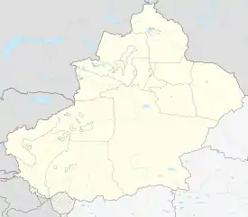
.png.webp) Location of Uqturpan County (red) within Aksu Prefecture (yellow) and Xinjiang | |
 Uqturpan Location of the seat in Xinjiang | |
| Coordinates: | |
| Country | People's Republic of China |
| Province | Xinjiang |
| Prefecture | Aksu Prefecture |
| Township-level divisions | 3 towns, 6 townships[1] |
| Elevation | 1,200−2,000 m (3,937−6,561 ft) |
| Population (2010)[3] | |
| • Total | 197,990 |
| Ethnic groups | |
| • Major ethnic groups | Uyghur[4] |
| Time zone | UTC+8 (China Standard) |
| Postal code | 843400 |
| Website | www |
| Uqturpan County | |||||||||||
|---|---|---|---|---|---|---|---|---|---|---|---|
| Uyghur name | |||||||||||
| Uyghur | ئۇچتۇرپان ناھىيىسى | ||||||||||
| |||||||||||
| Chinese name | |||||||||||
| Simplified Chinese | 乌什县 | ||||||||||
| Traditional Chinese | 烏什縣 | ||||||||||
| |||||||||||
| Alternative Chinese name | |||||||||||
| Simplified Chinese | 乌什吐鲁番县 | ||||||||||
| Traditional Chinese | 烏什吐魯番縣 | ||||||||||
| |||||||||||
Name
Uqturpan is also spelled Uchturpan and Uch-Turfan.[11]
History
Tang
During the Battle of Aksu (717), the Umayyad Caliphate and their Turgesh and Tibetan Empire allies hope to seize Uqturpan (then known as Dai-dʑiᴇk-dʑiᴇŋ) from Tang-Karluks-Exiled Western Turkic Khaganate allies but were repelled.[12]
Qing
Ush Turfan was the site of a battle between Barhanuddin and Abdulla during the Revolt of the Altishahr Khojas.[13][14] Six years after the Revolt of the Altishahr Khojas, ten years after the Qing's rescue of the Khoja Brothers from Dzungars, an anti-Qing uprising of the local Turkic (later "Uyghur") people took place in Uqturpan. Legend says that a local rebel leader was married to Iparhan, known as the "Fragrant Concubine" a descendant of Apaq Khoja. During the turmoil, many fled, and the thousands who remained were killed by Sino-Manchu forces. Later, the area was repopulated by migrants from what is now Southern Xinjiang.[15]
The Ush rebellion in 1765 by Uyghurs against the Manchus occurred after Uyghur women were gang raped by the servants and son of Manchu official Su-cheng.[16] It was said that Ush Muslims had long wanted to sleep on [Sucheng and son's] hides and eat their flesh. because of the rape of Uyghur Muslim women for months by the Manchu official Sucheng and his son.[17] The Manchu Emperor ordered that the Uyghur rebel town be massacred, the Qing forces enslaved all the Uyghur children and women and slaughtered the Uyghur men.[18] Manchu soldiers and Manchu officials regularly having sex with or raping Uyghur women caused massive hatred and anger by Uyghur Muslims to Manchu rule.[19]
21st century
In 2012, Aqyar Township (Aheya) was made a town.[3]
In a 2012 article from Radio Free Asia, it was reported that according to family sources and local authorities, Islam Urayim, then 32, a native of Uqturpan County who had been deported to China on December 19, 2009 despite seeking asylum in Cambodia, had been sentenced to life in prison. It was unclear when Urayim was sentenced or on what charges he was convicted.[20]
On April 3, 2015, Imam Township (Yimamu) was made a town.[21]
On October 27, 2019 at 1:29 PM, a 5.0-magnitude earthquake hit Uqturpan County. No casualties were reported.[5]
According to a 2020 Radio Free Asia report, it was estimated by local officials that 20,000 Uyghurs were detained in the three re-education camps in the county.[22]
Geography
The highest point in Uqturpan County is Zhatekelie Feng (扎特克列峰) at 5,135 m (16,847 ft) above sea level.[2]
59.9% of the territory of Uqturpan County is mountainous, 27.6% is Gobi-like desert areas and 12.5% is valley flatland.[2]
Administrative divisions
- Uqturpan Town (Uchturpan, Wushi; ئۇچتۇرپان بازىرى / 乌什镇), Aqyar[24] (Aheya, Akyar;[25] ئاقيار بازىرى / 阿合雅镇, formerly 阿合雅乡), Imam[26] (Yimamu, Imamlirim;[25] ئىمام بازىرى / 依麻木镇, formerly 依麻木乡)
Townships (يېزىسى / 乡):
- Aqtoqay Township (Aketuohai; ئاقتوقاي يېزىسى[27] / 阿克托海乡), Achatagh Township (Aqiatage; ئاچاتاغ يېزىسى[28] / 阿恰塔格乡), Yakowruk Township[29] (Yakeruike, Yakowrük;[25] ياكۆۋرۈك يېزىسى[30] / 亚科瑞克乡), Yengiawat Township[31] (Ying'awati; يېڭىئاۋات يېزىسى / 英阿瓦提乡), Otbeshi Township (Aotebeixi; ئوتبېشى يېزىسى[32] / 奥特贝希乡), Yamansu Kyrgyz Ethnic Township (يامانسۇ قىرغىز يېزىسى / 亚曼苏柯尔克孜族乡)
Demographics
| Year | Pop. | ±% p.a. |
|---|---|---|
| 2000 | 177,410 | — |
| 2010 | 197,990 | +1.10% |
| [3] | ||
As of 2015, 216,579 of the 235,336 residents of the county were Uyghur, 11,462 were Han Chinese, 5,613 were Kyrgyz and 1,682 were from other ethnic groups.[33]
As of 1999, 90.01% of the population of Uqturpan (Wushi) County was Uyghur and 6.73% of the population was Han Chinese.[34]
Economy
Uqturpan County's economy is primarily based on agriculture and animal husbandry, producing wheat, rice, corn, cotton, sesame (胡麻), rapeseed, and pelts. Industries include cooking oil processing, tractor repair, and construction among others.[35]
As of 1885, there was about 86,800 acres (572,793 mu) of cultivated land in Uqturpan.[36]
Historical maps
Historical English-language maps including Uqturpan:
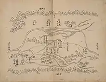
_p61_PLATE19._SINKIANG_(14597194848).jpg.webp) Map including Uqturpan (labeled as Uch Turfan) (1917)
Map including Uqturpan (labeled as Uch Turfan) (1917)_-_panoramio.jpg.webp) Map including Uqturpan (labeled as WU-SHIH (UCH TURFAN)) and surrounding region from the International Map of the World (AMS, 1950)[lower-alpha 1]
Map including Uqturpan (labeled as WU-SHIH (UCH TURFAN)) and surrounding region from the International Map of the World (AMS, 1950)[lower-alpha 1]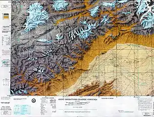 Map including Uqturpan (labeled as WU-SHIH (UCH TURFAN)) (DMA, 1973)
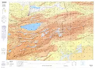 Map including Uqturpan (labeled as Wushi) (DMA, 1981)
 From the Operational Navigation Chart; map including Uqturpan (labeled as Wu-shih (Wushi)) (DMA, 1985)[lower-alpha 2]
Notes
- From map: "THE DELINEATION OF INTERNATIONAL BOUNDARIES ON THIS MAP MUST NOT BE CONSIDERED AUTHORITATIVE"
- From map: "The representation of international boundaries is not necessarily authoritative."
References
- 乌什县行政区划 [Uqturpan County Administrative Divisions]. ئۇچتۇرپان 乌什县人民政府. 8 February 2018. Retrieved 7 May 2020.
乌什县辖3个镇、6个乡:乌什镇、阿克托海乡、亚科瑞克乡、阿恰塔格乡、阿合雅镇、依麻木镇、英阿瓦提乡、亚曼苏乡、奥特贝希乡,共108个行政村527个村民小组、11个社区。县境内有:兵团一师四团。县人民政府驻乌什镇。
- 自然地理. ئۇچتۇرپان 乌什县人民政府 (in Chinese). 24 January 2018. Retrieved 8 May 2020.
北以天山山脉与吉尔吉斯斯坦共和国接壤。{...}境内国境边界线长155千米。
- 乌什县历史沿革 [Uqturpan County Historical Development] (in Chinese). XZQH.org. 27 May 2015. Retrieved 7 May 2019.
2000年第五次人口普查,乌什县常住总人口177410人,{...}2003年,乌什县总面积9064.76平方千米,{...}2010年第六次人口普查,乌什县常住总人口197990人,其中:乌什镇27836人,阿克托海乡22870人,亚科瑞克乡17023人,阿恰塔格乡17661人,阿合雅乡34588人,依麻木乡22669人,英阿瓦提乡17614人,亚曼苏柯尔克孜族乡8554人,奥特贝希乡23283人,兵团四团5892人。 2012年,自治区政府(新政函[2012]363号)批复同意撤销阿合雅乡,设立阿合雅镇。调整后,全县辖2个镇、7个乡(其中1个民族乡):乌什镇、阿合雅镇、阿克托海依乡、亚科瑞克乡、阿恰塔格乡、依麻木乡、英阿瓦提乡、亚曼苏柯尔克孜族乡、奥特贝希乡。 2015年4月3日,自治区政府(新政函[2015]86号)批复同意撤销依麻木乡,设立依麻木镇。调整后,全县辖3个镇、6个乡(其中1个民族乡)。
- 1997年乌什县行政区划 [1997 Uqturpan County Administrative Divisions]. XZQH.org (in Chinese). 10 November 2011. Retrieved 9 May 2020.
其中维吾尔族占90.4%,
- Li Xia, ed. (27 October 2019). "No casualties reported in Xinjiang earthquake". Xinhua News Agency. Retrieved 26 April 2020.
No casualties or economic loss have been reported after a 5.0-magnitude earthquake hit Uqturpan County of Aksu Prefecture, northwest China's Xinjiang Uygur Autonomous Region at 1:29 p.m. Sunday.
- Alan Taylor (8 May 2017). "Scenes From Xinjiang". The Atlantic. Retrieved 6 May 2020.
Students from ethnic minorities give the Young Pioneer's salute to their teacher (right) at a primary school in Uqturpan county, Xinjiang on May 3, 2012.
- Uqturpan (Approved - N) at GEOnet Names Server, United States National Geospatial-Intelligence Agency
- Rahman, Anwar (2005). Sinicization Beyond the Great Wall: China's Xinjiang Uighur Autonomous Region. Troubador Publishing Ltd. p. 69. ISBN 9781904744887.
- Choi Chi-yuk and Mandy Zuo (4 July 2013). "Xinjiang cadres try to quell unrest ahead of July 5 anniversary". South China Morning Post. Retrieved 7 May 2020.
The head of Uchturpan county's tourism bureau was sacked for being absent from duty, the People's Daily website reported.
CS1 maint: uses authors parameter (link) - Shohret Hoshur, Joshua Lipes (8 September 2020). "Young Uyghur Brothers Handed Five-Year Prison Terms For 'Viewing Illegal Videos'". Radio Free Asia. Translated by Elise Anderson. Retrieved 21 September 2020.
Aksu (in Chinese, Akesu) prefecture’s Uchturpan (Wushi) county,
- TURKESTAN (PDF). Encyclopædia Britannica. 33. 1902. p. 492 – via Wikimedia Commons.
Uch-Turfan
- Section 221 (Section 27 of the Chapter Records of Tang) of Zizhi Tongjian
- Hamid Wahed Alikuzai (October 2013). A Concise History of Afghanistan in 25 Volumes. Trafford Publishing. pp. 303–. ISBN 978-1-4907-1441-7.
- Demetrius Charles Boulger; Muḥammad Ya'ḳûb (amir of Kashgar.) (1878). The Life of Yakoob Beg: Athalik Ghazi, and Bradaulet ̱of Kashgar ; With Map and Appendix. pp. 47–.
- Laura J. Newby, "'Us and Them' in Eighteenth and Nineteenth Century Xinjiang," in Ildikó Bellér-Hann, et al., eds., Situating the Uyghurs between China and Central Asia (2007), p. 26.
- Millward, James A. (1998). Beyond the Pass: Economy, Ethnicity, and Empire in Qing Central Asia, 1759-1864. Stanford University Press. p. 124. ISBN 0804797927.
- Millward, James A. (2007). Eurasian Crossroads: A History of Xinjiang (illustrated ed.). Columbia University Press. p. 108. ISBN 978-0231139243.
- Millward, James A. (2007). Eurasian Crossroads: A History of Xinjiang (illustrated ed.). Columbia University Press. p. 109. ISBN 978-0231139243.
- Millward, James A. (1998). Beyond the Pass: Economy, Ethnicity, and Empire in Qing Central Asia, 1759-1864. Stanford University Press. pp. 206–207. ISBN 0804797927.
- Shohret Hoshur, Parameswaran Ponnudurai (16 January 2012). "Life in Prison for Asylum Seekers". Radio Free Asia. Translated by Shohret Hoshur. Retrieved 8 May 2020.
- "新疆维吾尔自治区人民政府关于同意乌什县依麻木乡撤乡设镇的批复(新政函〔2015〕86号)" (in Chinese). 2015-05-26. Archived from the original on 2017-09-21. Retrieved 2017-09-20.
2015年4月3日,自治区人民政府同意撤销乌什县依麻木乡建制,设立依麻木镇,其行政区域界线、政府驻地及隶属关系不变。
- Shohret Hoshur, Joshua Lipes (2 November 2020). "Six Camp Detainees From a Street in Xinjiang's Uchturpan Have Died or Are Seriously Ill". Radio Free Asia. Retrieved 10 November 2020.
- 2019年统计用区划代码和城乡划分代码:乌什县 [2019 Statistical Area Numbers and Rural-Urban Area Numbers: Uqturpan County] (in Chinese). National Bureau of Statistics of the People's Republic of China. 2019. Retrieved 6 May 2019.
统计用区划代码 名称 652927100000 乌什镇 652927101000 阿合雅镇 652927102000 依麻木镇 652927200000 阿克托海乡 652927201000 亚科瑞克乡 652927202000 阿恰塔格乡 652927205000 英阿瓦提乡 652927206000 亚曼苏柯尔克孜族乡 652927207000 奥特贝希乡
- Shohret Hoshur, Joshua Lipes (18 March 2020). "Missing Uyghur Brothers Confirmed Detained in Xinjiang Internment Camp". Radio Free Asia. Translated by Elise Anderson. Retrieved 9 May 2020.
township of Aqyar, in Aksu (in Chinese, Akesu) prefecture’s Uchturpan (Wushi) county,
CS1 maint: uses authors parameter (link) - Xie Yuzhong 解玉忠 (2003). 地名中的新疆 (in Chinese). Ürümqi: 新疆人民出版社. p. 182. ISBN 7-228-08004-1.
- Zhong Xingqi 钟兴麒, ed. (July 2008). 西域地名考录 (in Chinese). Beijing: 国家图书馆出版社. p. 1107. ISBN 978-7-5013-3628-9.
依麻木 yī má mù Imam 乡名。新疆乌什县依麻木乡,在县城东北20公里。
- 古丽米娜, ed. (5 June 2019). پارتىيە بايرىقىنى ئاساسىي قاتلام بازىسىدا ئېگىز جەۋلان قىلدۇرۇش. ﺷﯩﻨﺠﺎﯓ ﻛﯘﺋﯧﻨﻠﯘﻥ ﺗﻮﺭﻯ 昆仑网 新疆党建网 (in Uyghur). Retrieved 11 May 2020.
ئاقتوقاي يېزىسى
- ئامانگۈل ئابدۇراخمان, ed. (7 February 2020). ئىشقا ئورۇنلاشتۇرۇپ نامراتلىقتىن قۇتۇلدۇرۇشنىڭ «ئۈچ مېلودىيە»سىنى ياڭرىتىش. Tianshannet (in Uyghur). Retrieved 11 May 2020.
ئۇچتۇرپان ناھىيەسىنىڭ ئاچاتاغ يېزىسى
- Shohret Hoshur, Joshua Lipes (2014-08-11). "Farmer's Murder Raises New Concerns Among Uyghurs in Xinjiang". Radio Free Asia. Translated by Shohret Hoshur. Archived from the original on 12 September 2020 – via Internet Archive.
- كوللېكتىپ توي، تۇتاشقان قەلىبلەر(9). People's Daily (in Uyghur). 14 April 2014. Retrieved 11 May 2020.
ئۇچتۇرپان ناھىيەسى ياكۆۋرۈك يېزىسى
- Yengiawat (Approved - N) at GEOnet Names Server, United States National Geospatial-Intelligence Agency
- ياقۇپجان تۇرسۇن, ed. (6 January 2016). ئۇچتۇرپان ناھىيەسى: قارا مورلار تاماق ئۈستەللىرىگە چىقىپ، كەنت ئاھالىلىرى خۇشاللىققا چۆمدى. Tianshannet (in Uyghur). Retrieved 11 May 2020.
ئۇچتۇرپان ناھىيەسى ئوتبېشى يېزىسى
- 3-7 各地、州、市、县(市)分民族人口数 (in Chinese). شىنجاڭ ئۇيغۇر ئاپتونوم رايونى 新疆维吾尔自治区统计局 Statistic Bureau of Xinjiang Uygur Autonomous Region. 15 March 2017. Archived from the original on 11 October 2017. Retrieved 3 September 2017.
- Morris Rossabi, ed. (2004). Governing China's Multiethnic Frontiers (PDF). University of Washington Press. p. 179. ISBN 0-295-98390-6.
- 夏征农; 陈至立, eds. (September 2009). 辞海:第六版彩图本 [Cihai (Sixth Edition in Color)] (in Chinese). 上海. Shanghai: 上海辞书出版社. Shanghai Lexicographical Publishing House. p. 2398. ISBN 9787532628599.
- Herold J. Wiens (November 1966). "Cultivation Development and Expansion in China's Colonial Realm in Central Asia". The Journal of Asian Studies. 26 (1): 75. JSTOR 2051832 – via JSTOR.
| Look up Uqturpan, Wushi, or Wu-shih in Wiktionary, the free dictionary. |