Raub District
Raub District is a district in Pahang, Malaysia. Located in the west of Pahang, the district bordered Lipis District, Jerantut District, Temerloh District, Bentong District and Hulu Selangor District of Selangor clockwisely. Raub district consists of 7 mukim (sub-districts), namely Batu Talam, Sega, Semantan Ulu, Dong, Ulu Dong, Gali and Tras. With an area of 2,271 km², Raub district is situated in west of Pahang and between two range, Titiwangsa Range and Benom Mountain Range. Raub district also is home to Fraser's Hill.
Raub District | |
|---|---|
| Daerah Raub | |
| Other transcription(s) | |
| • Jawi | ﺭءﺍﻭﺏ |
| • Chinese | 劳勿县 |
| • Tamil | ரவுப் |
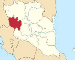 Location of Raub District in Pahang | |
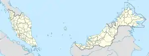 Raub District Location of Raub District in Malaysia | |
| Coordinates: 3°50′N 101°50′E | |
| Country | |
| State | |
| Seat | Raub |
| Local area government(s) | Raub District Council |
| Government | |
| • District officer | Handan Hussin[1] |
| Area | |
| • Total | 2,268.33 km2 (875.81 sq mi) |
| Population (2010)[3] | |
| • Total | 92,162 |
| • Density | 41/km2 (110/sq mi) |
| Time zone | UTC+8 (MST) |
| • Summer (DST) | UTC+8 (Not observed) |
| Postcode | 27xxx, 49xxx (Fraser's Hill) |
| Calling code | +6-09 |
| Vehicle registration plates | C |
Demographics
The following is based on Department of Statistics Malaysia 2010 census.[3]
| Ethnic groups in Raub, 2010 census | ||
|---|---|---|
| Ethnicity | Population | Percentage |
| Bumiputera | 58,325 | 63.3% |
| Chinese | 27,684 | 30.0% |
| Indian | 5,871 | 6.4% |
| Others | 282 | 0.3% |
| Total | 92,162 | 100% |
Federal Parliament and State Assembly Seats
Raub district representative in the Federal Parliament (Dewan Rakyat)
| Parliament | Seat Name | Member of Parliament | Party |
|---|---|---|---|
| P80 | Raub | Tengku Zulpuri Shah Raja Puji | Pakatan Harapan (DAP) |
List of Raub district representatives in the State Legislative Assembly (Dewan Undangan Negeri)
| Parliament | State | Seat Name | State Assemblyman | Party |
|---|---|---|---|---|
| P80 | N6 | Batu Talam | Abdul Aziz Mat Kiram | Perikatan Nasional (UMNO) |
| N7 | Tras | Chow Yu Hui | Pakatan Harapan (DAP) | |
| N8 | Dong | Shahiruddin Ab Moin | Perikatan Nasional (UMNO) |
Subdistricts
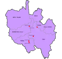
Raub District is divided into 7 mukims, which are:
- Batu Talam (57,000 Ha)
- Dong (7,500 Ha)
- Gali (65,300 Ha)(Capital)
- Hulu Dong (19,200 Ha)
- Sega (15,500 Ha)
- Semantan Hulu (33,400 Ha)
- Teras (29,000 Ha)
Townships
- Tras
- Batu Talam
- Dong
- Sang Lee
- Sungai Chetang
- Fraser's Hill
- Bukit Koman
- Simpang Kalang
- Cheroh
- Batu 12
- Sempalit
- Sungai Ruan
- Sungai Krau
- Sungai Lui
- Sungai Chalit
- Jenud
- Sega Lama
- Ulu Renggol
- Jeruas
- Sengkela
- Chenua
- Kuala Atok
- Ulu Atok
- Jeram Besu
- Felda Krau
- Felda Tersang
- Pos Buntu
- Felda Lembah Klau
See also
References
- User, Super. "Senarai Pegawai". pdtraub.pahang.gov.my.
- User, Super. "Latar Belakang". pdtraub.pahang.gov.my.
- "Population Distribution and Basic Demographic Characteristics, 2010" (PDF). Department of Statistics, Malaysia. Archived from the original (PDF) on 22 May 2014. Retrieved 19 April 2012.