Setiu District
Setiu is one of the districts in Terengganu, Malaysia. This district is bordered by Besut to the north, Hulu Terengganu to the west, and on the south, Kuala Nerus District.
Setiu District | |
|---|---|
| Daerah Setiu | |
| Other transcription(s) | |
| • Jawi | ستيو |
 Flag | |
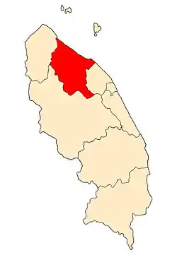 Location of Setiu District in Terengganu | |
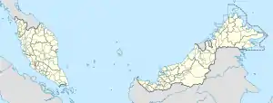 Setiu District Location of Setiu District in Malaysia | |
| Coordinates: 5°35′N 102°45′E | |
| Country | |
| State | |
| Seat | Bandar Permaisuri |
| Local area government(s) | Setiu District Council |
| Government | |
| • District officer | Haji Mohd Sophian bin Abu Bakar[1] |
| Area | |
| • Total | 1,304.36 km2 (503.62 sq mi) |
| Population (2010)[3] | |
| • Total | 54,405 |
| • Estimate (2014)[4] | 61,700 |
| • Density | 42/km2 (110/sq mi) |
| Time zone | UTC+8 (MST) |
| • Summer (DST) | UTC+8 (Not observed) |
| Postcode | 22xxx |
| Calling code | +6-09-6 |
| Vehicle registration plates | T |
Setiu is the second youngest and least populated district in Terengganu. Its capital is Bandar Permaisuri which also serves as its economic and commercial centre. Other towns are Chalok, Sungai Tong, and Penarik.
Etymology and history
The district of Setiu is believed to have taken its name from a Tok Setiu, a Bugis commander who escaped the Dutch conquest of the Indonesian archipelago in the 19th century and immigrated to Terengganu. The Sultan allowed Tok Setiu and his followers to open a kampong in the plains located north of Kuala Terengganu.
Setiu, as a district, had existed as early as the 1920s, with a smaller territory than its present-day borders, during the early days of British protection over Terengganu. In 1923 it was annexed into the neighbouring Besut District until 1935, when it was made a separate district. That same year Setiu district was partitioned between Besut district and the state capital Kuala Terengganu. Setiu district with its present-day borders was reorganised in 1985, merging Mukim Merang, Mukim Hulu Nerus and Mukim Belara (portion) from Kuala Terengganu (now Kuala Nerus) and Mukim Caluk, Mukim Guntung, Mukim Pantai Tasik and Mukim Hulu Setiu from Besut.[5][6]
Demographics
Majority of the inhabitants of Setiu are ethnic Malays, with remainder from the minority Chinese and Indian communities. Most Malays in Setiu especially in the northern part speaks Kelantan-Pattani Malay however those that live in southern Setiu speaks Terengganu Malay.
Administrative divisions

Setiu is divided into 7 mukims, which are:[2]
- Chaluk
- Guntung
- Hulu Nerus
- Hulu Setiu
- Merang
- Pantai
- Tasik
Tourist attractions
Among the places of interest in this district are Terengganu International Equestrian Park (TIEP), Setiu Wetlands, Lata Payung, Lata Changkah, Mount Tebu, Rhu Sepuluh Beach, and Terrapuri CUltural Village.
Federal Parliament and State Assembly Seats
List of LMS district representatives in the Federal Parliament (Dewan Rakyat)
| Parliament | Seat Name | Member of Parliament | Party |
|---|---|---|---|
| P34 | Setiu | Shaharizukirnain Abdul Kadir | Perikatan Nasional (PAS) |
List of LMS district representatives in the State Legislative Assembly of Terengganu
| Parliament | State | Seat Name | State Assemblyman | Party |
|---|---|---|---|---|
| P34 | N5 | Jabi | Azman Ibrahim | Perikatan Nasional (PAS) |
| P34 | N6 | Permaisuri | Abdul Halim Jusoh | Perikatan Nasional (UMNO) |
| P34 | N7 | Langkap | Sabri Mohd Noor | Perikatan Nasional (UMNO) |
| P34 | N8 | Batu Rakit | Bazlan Abdul Rahman | Perikatan Nasional (UMNO) |
References
- Administrator. "Laman Web Rasmi Pejabat Daerah Dan Tanah Dungun". pdtsetiu.terengganu.gov.my.
- Administrator. "LATARBELAKANG DAERAH SETIU". pdtsetiu.terengganu.gov.my.
- "Population Distribution and Basic Demographic Characteristics, 2010" (PDF). Department of Statistics, Malaysia. Archived from the original (PDF) on 22 May 2014. Retrieved 19 April 2012.
- Administrator. "Pengenalan Daerah Dungun". pdtdungun.terengganu.gov.my.
- "LATARBELAKANG DAERAH SETIU". Laman Web Rasmi Pejabat Daerah dan Tanah Setiu. Retrieved 3 December 2019.
- "Daerah di Terengganu". Ganupedia. Retrieved 3 December 2019.
State of Terengganu | |
|---|---|
Capital: Kuala Terengganu | |
| Topics |
|
| Society |
|
| Administrative divisions | |
| |