Tanah Merah District
Tanah Merah District (meaning Red Land or Laterite, Kelantanese: Tanoh Meghoh) is a district (jajahan) in the state of Kelantan in northeast Malaysia. The urban area of Tanah Merah is situated along the Kelantan River. It is bordered by Pasir Mas District in the north, Machang District to the East, Kuala Krai District to the South East, Jeli District to the South West and Thailand in the West.
Tanah Merah District | |
|---|---|
| Jajahan Tanah Merah | |
| Other transcription(s) | |
| • Jawi | تانه ميره |
| • Chinese | 丹那美拉县 |
| • Tamil | தானா மேரா |
 Flag | |
 Location of Tanah Merah District in Kelantan | |
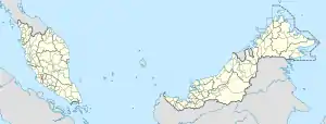 Tanah Merah District Location of Tanah Merah District in Malaysia | |
| Coordinates: 5°48′N 102°04′E | |
| Country | |
| State | |
| Seat | Tanah Merah |
| Local area government(s) | Tanah Merah District Council |
| Government | |
| • District officer | Norazman Abdul Ghani[1] |
| Area | |
| • Total | 867.6 km2 (335.0 sq mi) |
| Population (2010)[3] | |
| • Total | 117,338 |
| • Density | 140/km2 (350/sq mi) |
| Time zone | UTC+8 (MST) |
| • Summer (DST) | UTC+8 (Not observed) |
| Postcode | 17xxx |
| Calling code | +6-09 |
| Vehicle registration plates | D |
Historically it used to be a capital of a kingdom called Chi Tu. Chinese Sui Dynasty annals of the 7th century describe an advanced kingdom called Chi Tu ("Red Earth") in the area now called Kelantan. The ancient name for Kelantan was "Raktamrittika", meaning "Red Earth" — this was later changed to "Sri Wijaya Mala".[4]
Education
Several types of school can be found in Tanah Merah.[5] Among the schools in Tanah Merah are
- Maahad Ahmadi,Padang Siam, 17500 Tanah Merah (Sekolah agama yang perlukan bantuan)
- Sekolah Menengah Kebangsaan Alor Pasir, 17500 Tanah Merah
- Sekolah Menengah Kebangsaan Batu Gajah, 17510 Tanah Merah
- Sekolah Menengah Kebangsaan Belimbing, Jln. Tanah Merah-Pasir Mas, 17500 Tanah Merah
- Sekolah Menengah Kebangsaan Dato' Mahmud Paduka Raja (1), 17500 Tanah Merah
- Sekolah Menengah Kebangsaan Ipoh, 17500 Tanah Merah
- Sekolah Menengah Kebangsaan Kemahang, W/P Felda Kemahang, 17500 Tanah Merah
- Sekolah Menengah Kebangsaan Ladang Kerilla, Peti Surat 39, 17507 Tanah Merah
- Sekolah Menengah Kebangsaan Tanah Merah (1), 17500 Tanah Merah
- Sekolah Menengah Kebangsaan Tanah Merah (2)(SEMETAM2), 17500 Tanah Merah
- Kolej Vokasional Tanah Merah, Km.3, Jln. Tanah Merah-Machang, 17500 Tanah Merah
- Sekolah Menengah Kebangsaan Bukit Bunga, 17500 Tanah Merah
- Sekolah Menengah Kebangsaan Dato Mahmud Paduka Raja (2), 17500 Tanah Merah
Demographics
The total population in 2010 was about 117,338, the majority being Malays, with a small Chinese and Indian population. Immigrants, mostly from neighbouring Thailand, also make up a part of the population.[3]
Most of the population be distributed among various villages (or "kampung" in Malay) and suburb areas, while only a small proportion is located in the town.
Tanah Merah used to be a small town, but has seen major changes in the last decade when the younger generation started to migrate to cities along the Malaysian west coast for jobs with higher pay. Money sent back to their families has catalysed the growth, expansion and development of the town.
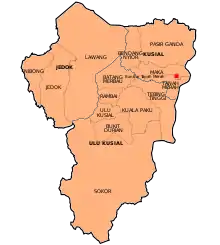
Ranking Population of Jajahan Tanah Merah.
| Rank | Daerah/Mukim | Population 2000 |
|---|---|---|
| 1 | Kusial | 46,737 |
| 2 | Jedok | 27,474 |
| 3 | Ulu Kusial | 27,298 |
Geography
The landscape of Tanah Merah is greatly influenced by the Kelantan River (Malay: Sungai Kelantan) which supplies much needed water to its agricultural plantations. Mt. Kemahang (876 m or 2,874 ft) and Mt. Kusial (723 m or 2,372 ft) are both located in the western part of Tanah Merah.
Federal Parliament and State Assembly Seats
List of Tanah Merah district representatives in the Federal Parliament (Dewan Rakyat)
| Parliament | Seat Name | Member of Parliament | Party |
|---|---|---|---|
| P27 | Tanah Merah | Ikmal Hisham Abdul Aziz | Perikatan Nasional (PPBM) |
List of LMS district representatives in the State Legislative Assembly.
| Parliament | State | Seat Name | State Assemblyman | Party |
|---|---|---|---|---|
| P27 | N26 | Bukit Panau | Abdul Fatah Mahmood | Perikatan Nasional (PAS) |
| P27 | N27 | Gual Ipoh | Bakri Mustapha | Barisan Nasional (UMNO) |
| P27 | N28 | Kemahang | Md. Anizam Ab. Rahman | Perikatan Nasional (PAS) |
Transportation
Highway 4 is the main highway serving the constituency. Highway 129 is a shortcut to Pasir Mas.
KTM Intercity has a station in Tanah Merah town.
Shopping
- Aneka
- Jaya Gading
- Pantai Timor Shopping Centre
- Salamku
- Tesco (proposed)
- Merah Mall (upcoming projects)
References
- User, Super. "Laman Web Rasmi Pejabat Tanah Dan Jajahan Tanah Merah - Perutusan Ketua Jajahan". www.ptjtm.kelantan.gov.my.
- User, Super. "Laman Web Rasmi Pejabat Tanah Dan Jajahan Tanah Merah - Sejarah PTJTM". www.ptjtm.kelantan.gov.my.
- "Population Distribution and Basic Demographic Characteristics, 2010" (PDF). Department of Statistics, Malaysia. Archived from the original (PDF) on 22 May 2014. Retrieved 19 April 2012.
- Zulkifli B. Mohamad (2002). "Evanescent Kingdoms, Everlasting Spirit". MIS Center PSU Pattani. Archived from the original on August 10, 2004. Retrieved 2007-06-10.
- "Secondary Schools in Kelantan, Malaysia". 2007. Retrieved 2007-12-10.
| Wikimedia Commons has media related to Tanah Merah District. |
Capital: Kota Bharu, Royal town: Kubang Kerian | |||||
| Topics |
| ||||
| Society |
| ||||
| Administrative divisions |
| ||||
| |||||