Machang District
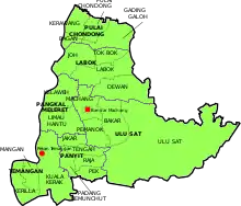
Machang is one of the ten districts in the state of Kelantan, Malaysia. It is situated at the centre of the state, bordering with Kelantanese territories of Kota Bharu to the north, Pasir Puteh to the east, Tanah Merah to the west and Kuala Krai to the south. Its major town and administrative centre is Bandar Machang.
Machang District | |
|---|---|
| Jajahan Machang | |
| Other transcription(s) | |
| • Jawi | ماچڠ |
| • Chinese | 马樟县 |
| • Tamil | மாச்சாங் |
 Flag | |
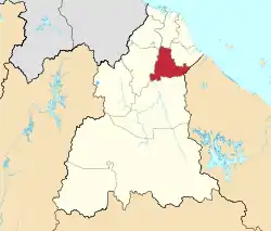 Location of Machang District in Kelantan | |
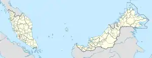 Machang District Location of Machang District in Malaysia | |
| Coordinates: 5°45′N 102°15′E | |
| Country | |
| State | |
| As sub-district | 1949 |
| As full district | 1952 |
| Seat | Machang |
| Local area government(s) | Machang District Council |
| Government | |
| • District officer | Ibrahim Bakri Mat Deris[1] |
| Area | |
| • Total | 546.26 km2 (210.91 sq mi) |
| Population (2010)[3] | |
| • Total | 92,149 |
| • Density | 170/km2 (440/sq mi) |
| Time zone | UTC+8 (MST) |
| • Summer (DST) | UTC+8 (Not observed) |
| Postcode | 18xxx |
| Calling code | +6-09 |
| Vehicle registration plates | D |
History
Previously part of Ulu Kelantan,[4] around 1949, Machang was delineated as an autonomous sub-district of Kelantan. Owing to its rapid pace of development and active economic sector, Machang was upgraded as a full District on January 1, 1952.[5] The territory is still largely agrarian, home to a lot of paddy fields, palm and rubber plantations.
Attractions
Among the attractions that get frequented a lot in Machang District are the hot springs that are situated in Kampung Rengas Tok Bok, Hutan Lipur Bukit Bakar,[6] Air Terjun Jeram Linang[7] and Hutan Lipur Cabang Tongkat.
Educational Institution
The district is the host for the Universiti Teknologi Mara (Machang Branch), 9 national secondary schools, 1 fully residential school, 3 State-Funded Islamic religious school and 20 national primary schools which include a Chinese vernacular national type primary school.
University
- Universiti Teknologi Mara Machang (UiTM)
National Schools
- Sekolah Menengah Kebangsaan Machang
- Sekolah Menengah Kebangsaan Hamzah 1
- Sekolah Menengah Kebangsaan Hamzah 2
- Sekolah Menengah Kebangsaan Bandar Machang
- Sekolah Menengah Kebangsaan Abdul Samad
- Sekolah Menengah Kebangsan Agama Wataniah Machang
- Sekolah Menengah Kebangsaan Sri Intan
- Sekolah Menengah Kebangsaan Temangan
- Sekolah Menengah Kebangsaan Pangkal Meleret
Fully Residential School
- Sekolah Menengah Sains Machang
State Funded Islamic Religious School
- Maahad Tahfiz Al Quran Wal Qiraat
- Maahad Syamsul Maarif Lelaki
- Maahad Syamsul Maarif Perempuan
National Schools
- Sekolah Kebangsaan Ayer Merah
- Sekolah Kebangsaan Bandar
- Sekolah Kebangsaan Bukit Tiu
- Sekolah Kebangsaan Belukar
- Sekolah Kebangsaan Dewan Besar
- Sekolah Kebangsaan Hamzah (1)
- Sekolah Kebangsaan Hamzah (2)
- Sekolah Kebangsaan Kampung Pek
- Sekolah Kebangsaan Labok
- Sekolah Kebangsaan Machang (1)
- Sekolah Kebangsaan Machang (2)
- Sekolah Kebangsaan Mata Ayer
- Sekolah Kebangsaan Pulai Chondong
- Sekolah Kebangsaan Pak Roman
- Sekolah Kebangsaan Pangkal Gong
- Sekolah Kebangsaan Pangkal Meleret
- Sekolah Kebangsaan Pangkal Nering
- Sekolah Kebangsaan Pangkal Jenereh
- Sekolah Kebangsaan Pulai Chondong
- Sekolah Kebangsaan Temangan
- Sekolah Kebangsaan Tok Bok
National School (Chinese Vernacular)
- Sekolah Jenis Kebangsaan (C) Pei Hwa
Demographics
As of 2010, Machang has a population of 92,149 people.[3]
Ranking Population of Jajahan Machang.
| Rank | Daerah/Mukim | Population 2000 |
|---|---|---|
| 1 | Ulu Sat | 26,800 |
| 2 | Pulai Chondong | 12,661 |
| 3 | Labok | 12,136 |
| 4 | Panyit | 10,330 |
| 5 | Pangkal Meleret | 10,225 |
| 6 | Temangan | 5,608 |
Federal Parliament and State Assembly Seats
List of LMS district representatives in the Federal Parliament (Dewan Rakyat)
| Parliament | Seat Name | Member of Parliament | Party |
|---|---|---|---|
| P29 | Machang | Ahmad Jazlan Yaakob | Barisan Nasional (UMNO) |
List of LMS district representatives in the State Legislative Assembly of Kelantan
| Parliament | State | Seat Name | State Assemblyman | Party |
|---|---|---|---|---|
| P29 | N33 | Pulai Chondong | Azhar Salleh | Perikatan Nasional (PAS) |
| P29 | N34 | Temangan | Mohamed Fadzli Hassan | Perikatan Nasional (PAS) |
| P29 | N35 | Kemuning | Mohd Roseli Ismail | Perikatan Nasional (PAS) |
Transportation
Highways 4 and 8 intersect in Machang.
KTM Intercity does not serve Machang town; however there is a railway halt in Temangan town about 10 km from Machang town centre. The halt is the only railway station operating in the Machang constituency.
References
- User, Super. "Laman Web Rasmi Pejabat Tanah Dan Jajahan Machang - Perutusan Ketua Jajahan". www.ptjm.kelantan.gov.my. Archived from the original on 2018-10-18. Retrieved 2017-11-27.
- User, Super. "Laman Web Rasmi Pejabat Tanah Dan Jajahan Machang - Sejarah". www.ptjm.kelantan.gov.my. Archived from the original on 2018-10-18. Retrieved 2016-10-17.
- "Population Distribution and Basic Demographic Characteristics, 2010" (PDF). Department of Statistics, Malaysia. Archived from the original (PDF) on 22 May 2014. Retrieved 19 April 2012.
- "Raremaps.com". Retrieved 10 January 2017.
- "Sejarah". Laman Web Rasmi Pejabat Tanah dan Jajahan Machang. Archived from the original on 18 October 2018. Retrieved 17 October 2016.
- Hutan Lipur Bukit Bakar
- Air Terjun Jeram Linang
External links
| Wikimedia Commons has media related to Machang District. |
Capital: Kota Bharu, Royal town: Kubang Kerian | |||||
| Topics |
| ||||
| Society |
| ||||
| Administrative divisions |
| ||||
| |||||