Segamat District
The Segamat District is a district located north of the state of Johor in Malaysia. The district capital is Segamat Town. In fact, local folklore says Segamat is a derivative of "Segar Amat" with the words spoken by Bendahara Tepok Bendahara of Sultanate of Malacca as he approached Segamat River to have some fresh drinks. It is not known when the name Segamat was used, but before the town of Segamat became known as Segamat, it was known as the Rantau Panjang. Rantau Panjang location is believed to be located on the banks of the Segamat river (location the old movie theater site Cathay / Motorcycle Shop) starting from the old Kuala Segamat River (dead river Segamat) across the railway about length 1 km.
Segamat District | |
|---|---|
| Daerah Segamat | |
| Other transcription(s) | |
| • Jawi | سڬامت |
| • Chinese | 昔加末县 |
| • Tamil | சிகாமட் |
 Flag | |
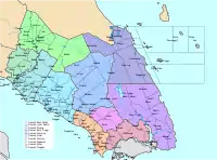
 Location of Segamat District in Johor | |
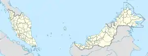 Segamat District Location of Segamat District in Malaysia | |
| Coordinates: 2°30′N 102°55′E | |
| Country | |
| State | |
| Seat | Segamat |
| Local area government(s) | Segamat Municipal Council (Segamat North) Labis District Council (Segamat South) |
| Government | |
| • District officer | Haji Nasri Bin Md Ali |
| Area | |
| • Total | 2,807.29 km2 (1,083.90 sq mi) |
| Population (2010)[2] | |
| • Total | 179,342 |
| • Density | 64/km2 (170/sq mi) |
| Time zone | UTC+8 (MST) |
| • Summer (DST) | UTC+8 (Not observed) |
| Postcode | 85xxx |
| Calling code | +6-07 |
| Vehicle registration plates | J |
Geology
There are three main rivers pass by the district, which are Batu Pahat River (as Simpang Kiri River) , Endau River and Muar River. Other rivers are Bekok River, Chodan River, Kenawar/Genuang River, Batang Lesong River, Bongor River, Emas River, Gemas River, Jasin River, Jementah River, Labis River, Legeh River, Mempedak River, Merlimau River, Mutan River, Palong River, Paya Mengkuang River, Penarah River, Rengit River, Segamat River, Kapeh River, Selai River, Semerong River, Senarut Hilir River, Spang Loi River and Tatat River.[3]
Administrative divisions
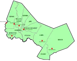
Segamat is divided into 11 subdistricts or mukims. Each mukim is administered by a headman or penghulu.[4]
- Sungai Segamat - houses about three-quarter of Segamat Town.
- Gemereh - the smallest mukim in Segamat
- Bekok - the largest mukim in Segamat
- Jabi
- Sermin
- Buloh Kasap
- Jementah
- Pogoh
- Labis
- Chaah
- Gemas
Mukim Sungai Segamat is the most populous mukim in Segamat District with a population of 48,512 people. The highest population density is in Mukim Gemereh, followed by Mukim Sungai Segamat with over 200+ residents per square km. The lowest population density is in Mukim Bekok with about 50 residents per square km.
Government
The Segamat district is divided by two municipal administratives namely Segamat Municipal Council based at Segamat Town and Labis District Council seated at Labis Town.
Segamat Municipal Council administers the northwestern half of the district covering mukim Buloh Kasap, Gemas, Gemereh, Jabi, Jementah, Pagoh, Sermin and Sungai Segamat with a total administrative area of 129 km2 (50 sq mi).
Labis District Council administers the southwestern half of the district covering mukim Bekok, Chaah and Labis, with a total administrative area of 122 km2 (47 sq mi).[5]
Other towns in Segamat District
- Segamat Baru
- Bukit Siput
- Bandar Putra (IOI)
- Taman Yayasan
- Batu Anam
- Pogoh
- Gemas Baharu
- Kampung Tengah
- Bandar Utama
- Jementah
- Buloh Kasap
- Labis
- Tenang Stesen
- Sungai Karas
Demographics
The annual population growth of Segamat District between 2010-2015 was 0.66%.[6]
Economy
The main economy activities in the district are agriculture, agritourism, ecotourism and light manufacturing.[7] Main agriculture produces are palm oil and rubber.[8]
Education
Tertiary education
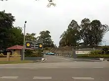
The district is home to two institutions: the Johor branch of the Universiti Teknologi Mara which is located about 8 kilometres or a 10-minute drive from the town; and the Johor campus of the Tunku Abdul Rahman University College where peoples called TAR UC (previously known as KTAR) which began operating on 18 May 1998, located at an approximate 10-to-15 minutes driving distance south from the town. There is also a community college named Kolej Komuniti Segamat located at Bandar Putra IOI Segamat, a 7-kilometres drive from town,[9] that began its operations in June 2001.
Primary and secondary education
There are about 18 primary schools in the district. On the other hand, there are 19 secondary schools within the Segamat township. Some of those notable secondary schools include SMK Dato' Bentara Dalam, SMK Agama Segamat, SMK Seri Kenangan Batu Anam, SMK Bekok, Sekolah Menengah Seg Hwa, Segamat High School and SMK Canossian Convent. While for primary school, some notable school include SK Kampong Jawa, SK Bukit Hampar, SK Bandar Putra and SK Canossion Convent.
Tourist attractions
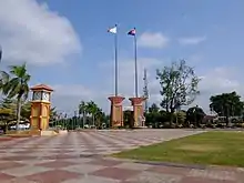
- Segamat Square (Malay: Dataran Segamat) - The square was constructed in 1996 as the main venue for Johor's state level celebration of the Malaysian National Day. In 2005, when Segamat was once again chosen as the state-level host, Dataran Segamat was renovated. It also houses the clock tower and a durian replica that makes Dataran Segamat the landmark of Segamat. Location: 2°30'40"N ; 102°48'50"E.
- Taman Bunga Batu Hampar (Rock Garden) - The Rock Garden is the main recreational park in Segamat. It also houses the official residence of the District Officer of Segamat and also the Shooting Box (Istana Hinggap), Johor royal retreat. Location: 2°30'59"N ; 102°48'43"E.[10]
- Bendahara Tepok Tomb - The tomb of the final Bendahara of Sultanate of Malacca located at Kampung Lubok Batu, about 2 km from Segamat town center via Federal Route 23. Location: 2°30'03"N ; 102°48'30"E.
Transportation
Road
Segamat district is served by the state rail network KTM with Batu Anam, Bekok, Genuang, Labis, Segamat and Tenang Stations.
Water
The district houses the Segamat Inland Port.[11]
References
- http://ptj.johor.gov.my/index.php/pejabat-tanah/pejabat-tanah-segamat/profil-daerah
- "Population Distribution and Basic Demographic Characteristics, 2010" (PDF). Department of Statistics, Malaysia. Archived from the original (PDF) on 22 May 2014. Retrieved 19 April 2012.
- http://apps.water.gov.my/jpskomuniti/dokumen/Segamat%20Profil%20(LATEST).pdf
- http://apps.water.gov.my/jpskomuniti/dokumen/Segamat%20Profil%20(LATEST).pdf
- http://apps.water.gov.my/jpskomuniti/dokumen/Segamat%20Profil%20(LATEST).pdf
- http://jpbd.johor.gov.my/images/jpbd_DokumenTerbitan/Handbook.pdf
- "Muafakat ke Arah #Johor Berkemajuan" (PDF). Muafakat Johor (in Malay). Retrieved 17 March 2018.
- "Profil Daerah". Portal Rasmi Pentadbiran Tanah Johor (in Malay). Retrieved 28 September 2018.
- "Kolej Komuniti Segamat". Archived from the original on 14 January 2008.
- Shooting Box, Segamat. Kemahkotaan DYMM Sultan Johor
- "Jabatan Perancangan Bandar dan Desa Negeri Johor" (PDF). Plan Malaysia @ Johor (in Malay). Retrieved 26 March 2018.
External links
| Wikimedia Commons has media related to Segamat District. |
- Segamat Municipal Council Official Web
- Dato Bendahara Luar