Ryer Island (Suisun Bay)
Ryer Island is an island in Suisun Bay[2] at the mouth of the Sacramento-San Joaquin River Delta in Solano County, California, in the Suisun Resource Conservation District, eight miles east-northeast of Benicia. At the time of statehood it was known as Kings Island.[3][4]
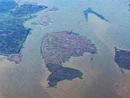 Ryer Island is the large, dolphin-shaped island in the center of this aerial photo. Directly above it and to the left is Freeman Island, and above Freeman Island is Snag Island. To its right is Roe Island. | |
Ryer Island 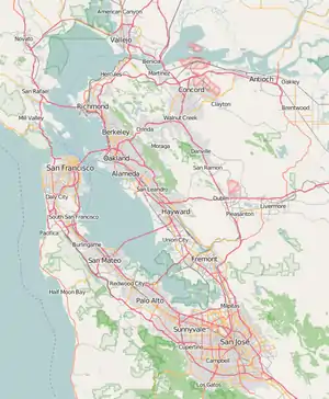 Ryer Island  Ryer Island  Ryer Island | |
| Geography | |
|---|---|
| Location | Northern California |
| Coordinates | 38°04′58″N 122°05′52″W[1] |
| Adjacent bodies of water | Suisun Bay |
| Administration | |
| State | |
| County | Solano |
See also
References
- U.S. Geological Survey Geographic Names Information System: Ryer Island
- U.S. Coast and Geodetic Survey (1927). Special Publications. Special Publications. U.S. Government Printing Office. p. 47. Retrieved July 16, 2020.
- David Rumsey Historical Map Collection, Bai San Francisco und Vereinigung des Sacramento mit dem San Joaquin, Henry Lange, 1854.
- David L. Durham, California's Geographic Names: A Gazetteer of Historic and Modern Names of This State. p. 693. Quill Driver Books. (1998) ISBN 1-884995-14-4.
Map: Islands of Suisun Bay and the Sacramento–San Joaquin River Delta | |
|---|---|
This article is issued from Wikipedia. The text is licensed under Creative Commons - Attribution - Sharealike. Additional terms may apply for the media files.