Sacagawea Peak
Sacagawea Peak is the highest mountain in the Bridger Range in south-western Montana.[3] The peak is named for Sacagawea, a Lemhi Shoshone woman that accompanied the Lewis and Clark Expedition.
| Sacagawea Peak | |
|---|---|
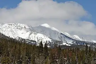 Sacagawea Peak viewed from the south-east. | |
| Highest point | |
| Elevation | 9,654 ft (2,943 m) [1] |
| Prominence | 3,930 ft (1,200 m) [1] |
| Coordinates | 45° 53' 45 N, 110° 58' 7 W45°53′45″N 110°58′7″W [2] |
| Geography | |
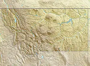 Sacagawea Peak Location in Montana  Sacagawea Peak Location in the United States | |
| Location | Gallatin County, Montana, U.S. |
| Parent range | Bridger Range |
| Topo map | USGS Sacagawea Peak |
| Climbing | |
| Easiest route | Hike |
Recreation
The mountain is a popular hiking destination. The main trailhead starts at 7,788 feet and climbs 1,800 feet reaching the summit in 2 miles.[4] The mountain holds snow in chutes through the early summer and local skiers often ski there through August.
References
- "Sacagawea Peak, Montana". Peakbagger.com. Retrieved September 16, 2020.
- "Sacagawea Peak". Peakbagger.com. Retrieved September 16, 2020.
- Writer, Story and Photography by Allison Goebel Chronicle Staff. "The great adventure to The Great One". Bozeman Daily Chronicle. Retrieved 2020-09-16.
- "Sacagawea Peak Hiking Trail, Bozeman, Montana". hikingproject.com.
This article is issued from Wikipedia. The text is licensed under Creative Commons - Attribution - Sharealike. Additional terms may apply for the media files.