Treasure County, Montana
Treasure County is a county in the U.S. state of Montana. As of the 2010 United States Census, the population was 718,[1] making it the second-least populous county in Montana. Its county seat is Hysham.[2] The county was founded in 1919.[3]
Treasure County | |
|---|---|
 | |
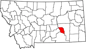 Location within the U.S. state of Montana | |
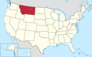 Montana's location within the U.S. | |
| Coordinates: 46°12′N 107°16′W | |
| Country | |
| State | |
| Founded | 1919 |
| Seat | Hysham |
| Largest town | Hysham |
| Area | |
| • Total | 984 sq mi (2,550 km2) |
| • Land | 977 sq mi (2,530 km2) |
| • Water | 6.6 sq mi (17 km2) 0.7% |
| Population (2010) | |
| • Total | 718 |
| • Estimate (2019) | 696 |
| • Density | 0.73/sq mi (0.28/km2) |
| Time zone | UTC−7 (Mountain) |
| • Summer (DST) | UTC−6 (MDT) |
| Congressional district | At-large |
| |
Geography
According to the U.S. Census Bureau, the county has a total area of 984 square miles (2,550 km2), of which 977 square miles (2,530 km2) is land and 6.6 square miles (17 km2) (0.7%) is water.[4] It is the fourth-smallest county in Montana by land area.
Adjacent counties
- Rosebud County - northeast
- Big Horn County - south
- Yellowstone County - west
Demographics
| Historical population | |||
|---|---|---|---|
| Census | Pop. | %± | |
| 1920 | 1,990 | — | |
| 1930 | 1,661 | −16.5% | |
| 1940 | 1,499 | −9.8% | |
| 1950 | 1,402 | −6.5% | |
| 1960 | 1,345 | −4.1% | |
| 1970 | 1,069 | −20.5% | |
| 1980 | 981 | −8.2% | |
| 1990 | 874 | −10.9% | |
| 2000 | 861 | −1.5% | |
| 2010 | 718 | −16.6% | |
| 2019 (est.) | 696 | [5] | −3.1% |
| US Decennial Census[6] 1790-1960[7] 1900-1990[8] 1990-2000[9] 2010-2019[1] | |||
2000 census
As of the 2000 United States Census,[10] there were 861 people, 357 households, and 242 families in the county. The population density was <1/km2 (1/sq mi). There were 422 housing units at an average density of 0.4/square mile (0.2/km2). The racial makeup of the county was 96.40% White, 0.12% Black or African American, 1.63% Native American, 0.35% Asian, 0.93% from other races, and 0.58% from two or more races. 1.51% of the population were Hispanic or Latino of any race. 29.2% were of German, 14.4% Norwegian, 11.2% Irish, 9.2% American and 5.5% English ancestry.
There were 357 households, out of which 30.80% had children under the age of 18 living with them, 59.10% were married couples living together, 4.20% had a female householder with no husband present, and 32.20% were non-families. 30.00% of all households were made up of individuals, and 15.10% had someone living alone who was 65 years of age or older. The average household size was 2.41 and the average family size was 2.98.
The county population contained 27.80% under the age of 18, 5.00% from 18 to 24, 23.20% from 25 to 44, 27.30% from 45 to 64, and 16.70% who were 65 years of age or older. The median age was 42 years. For every 100 females, there were 104.00 males. For every 100 females age 18 and over, there were 101.90 males.
The median income for a household in the county was $29,830, and the median income for a family was $34,219. Males had a median income of $22,750 versus $17,188 for females. The per capita income for the county was $14,392. About 8.50% of families and 14.70% of the population were below the poverty line, including 22.80% of those under age 18 and 11.10% of those age 65 or over.
2010 census
As of the 2010 United States Census, there were 718 people, 335 households, and 219 families residing in the county.[11] The population density was 0.7 inhabitants per square mile (0.27/km2). There were 422 housing units at an average density of 0.4/square mile (0.2/km2).[12] The racial makeup of the county was 93.9% white, 0.8% American Indian, 0.4% Asian, 1.9% from other races, and 2.9% from two or more races. Those of Hispanic or Latino origin made up 3.5% of the population.[11] In terms of ancestry, 40.2% were American, 22.4% were German, 9.9% were English, 9.9% were Irish, and 7.4% were Norwegian.[13]
Of the 335 households, 22.4% had children under the age of 18 living with them, 58.5% were married couples living together, 2.1% had a female householder with no husband present, 34.6% were non-families, and 32.5% of all households were made up of individuals. The average household size was 2.14 and the average family size was 2.67. The median age was 51.5 years.[11]
The median income for a household in the county was $37,969 and the median income for a family was $51,458. Males had a median income of $38,194 versus $26,563 for females. The per capita income for the county was $20,882. About 4.6% of families and 8.2% of the population were below the poverty line, including 15.2% of those under age 18 and 5.6% of those age 65 or over.[14]
Politics
Treasure County voters are reliably Republican. They have only selected the Democratic Party candidate in five national elections (as of 2016) during the century of the county's existence as an independent unit.
| Year | Republican | Democratic | Third parties |
|---|---|---|---|
| 2016 | 79.2% 351 | 13.3% 59 | 7.5% 33 |
| 2012 | 70.1% 319 | 25.1% 114 | 4.8% 22 |
| 2008 | 64.6% 314 | 32.1% 156 | 3.3% 16 |
| 2004 | 72.2% 348 | 25.1% 121 | 2.7% 13 |
| 2000 | 71.8% 344 | 22.1% 106 | 6.1% 29 |
| 1996 | 47.6% 237 | 34.3% 171 | 18.1% 90 |
| 1992 | 37.7% 206 | 28.7% 157 | 33.6% 184 |
| 1988 | 54.3% 291 | 43.1% 231 | 2.6% 14 |
| 1984 | 61.3% 353 | 36.3% 209 | 2.4% 14 |
| 1980 | 57.9% 321 | 32.7% 181 | 9.4% 52 |
| 1976 | 55.9% 315 | 42.4% 239 | 1.8% 10 |
| 1972 | 65.7% 377 | 30.7% 176 | 3.7% 21 |
| 1968 | 56.6% 298 | 35.7% 188 | 7.8% 41 |
| 1964 | 46.8% 251 | 53.2% 285 | 0.0% 0 |
| 1960 | 52.6% 300 | 47.4% 270 | 0.0% 0 |
| 1956 | 57.2% 337 | 42.8% 252 | 0.0% 0 |
| 1952 | 65.7% 392 | 34.3% 205 | 0.0% 0 |
| 1948 | 45.2% 253 | 52.0% 291 | 2.9% 16 |
| 1944 | 50.1% 287 | 49.2% 282 | 0.7% 4 |
| 1940 | 47.1% 287 | 52.6% 321 | 0.3% 2 |
| 1936 | 36.5% 244 | 59.5% 398 | 4.0% 27 |
| 1932 | 46.3% 276 | 52.0% 310 | 1.7% 10 |
| 1928 | 65.4% 354 | 34.4% 186 | 0.2% 1 |
| 1924 | 55.4% 289 | 16.1% 84 | 28.5% 149 |
| 1920 | 71.4% 517 | 24.0% 174 | 4.6% 33 |
See also
References
- "State & County QuickFacts". US Census Bureau. Retrieved September 16, 2013.
- "Find a County". National Association of Counties. Retrieved June 7, 2011.
- Montana Place Names from Alzada to Zortman. Helena, MT: Montana Historical Society Press. 2009. p. 267.
- "2010 Census Gazetteer Files". US Census Bureau. August 22, 2012. Archived from the original on December 5, 2014. Retrieved November 30, 2014.
- "Population and Housing Unit Estimates". Retrieved October 27, 2020.
- "US Decennial Census". US Census Bureau. Retrieved November 30, 2014.
- "Historical Census Browser". University of Virginia Library. Retrieved November 30, 2014.
- "Population of Counties by Decennial Census: 1900 to 1990". US Census Bureau. Retrieved November 30, 2014.
- "Census 2000 PHC-T-4. Ranking Tables for Counties: 1990 and 2000" (PDF). US Census Bureau. Retrieved November 30, 2014.
- "U.S. Census website". US Census Bureau. Retrieved January 31, 2008.
- "Profile of General Population and Housing Characteristics: 2010 Demographic Profile Data". US Census Bureau. Archived from the original on February 13, 2020. Retrieved January 10, 2016.
- "Population, Housing Units, Area, and Density: 2010 - County". UStates Census Bureau. Archived from the original on February 13, 2020. Retrieved January 10, 2016.
- "Selected Social Characteristics in the US – 2006-2010 American Community Survey 5-Year Estimates". US Census Bureau. Archived from the original on February 13, 2020. Retrieved January 10, 2016.
- "Selected Economic Characteristics – 2006-2010 American Community Survey 5-Year Estimates". US Census Bureau. Archived from the original on February 13, 2020. Retrieved January 10, 2016.
- Leip, David. "Atlas of US Presidential Elections". uselectionatlas.org. Retrieved April 3, 2018.
Places adjacent to Treasure County, Montana | ||||||||||
|---|---|---|---|---|---|---|---|---|---|---|
| ||||||||||
Municipalities and communities of Treasure County, Montana, United States | ||
|---|---|---|
| Town | Treasure County map | |
| Unincorporated communities | ||
| Ghost town | ||
| Indian reservation | ||
| Footnotes | ‡This populated place also has portions in an adjacent county or counties | |
| ||
| Authority control |
|---|