Gagetown, New Brunswick
Gagetown (2016 population: 711)[2] is a village in Queens County, New Brunswick, Canada. It is situated on the west bank of the Saint John River and is the county's shire town.
Village of Gagetown | |
|---|---|
Village | |
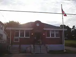 Gagetown village post office | |
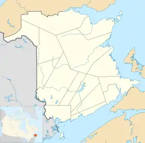 Village of Gagetown Location of Gagetown, New Brunswick | |
| Coordinates: 45.77°N 66.16°W | |
| Country | |
| Province | |
| County | Queens |
| Parish | Gagetown |
| Village Status | 1966 |
| Government | |
| • Type | Village Council |
| • Mayor | Mike Blaney |
| Area | |
| • Land | 49.47 km2 (19.10 sq mi) |
| Population (2016)[2] | |
| • Total | 711 |
| • Density | 14.4/km2 (37/sq mi) |
| • Change 2011-16 | |
| Time zone | UTC-4 (AST) |
| • Summer (DST) | UTC-3 (ADT) |
| Area code(s) | 506 |
| Dwellings | 339 |
| Median Income* | $62,976 CDN |
| Access Routes | |
| |
History
Acadians
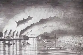
Gagetown was originally named Grimross by the Acadians and Maliseet, who lived there prior to the Expulsion of the Acadians. The Raid on Grimross occurred during the St. John River Campaign (1758–59). During the Expulsion of the Acadians, many Acadians fled from various parts of the Maritimes to villages along the Saint John River. The St. John River Campaign occurred during the French and Indian War when Colonel Robert Monckton led a force of 1150 British soldiers to destroy the Acadian settlements on the banks of the Saint John River until they reached the largest village of Ste Anne's Point (present day Fredericton, New Brunswick) in February 1759.[3] There were 2000 Acadians on the Saint John River, many of whom were refugees trying to escape the Expulsion of the Acadians.[4]
On November 4, 1758, British Officer, Monckton entered the nearly vacant village and the Rangers chased down and scalped Acadians.[5] They burned 50 buildings, crops and killed the animals.[6]
The name of the village is derived from British General Sir Thomas Gage. Major General Thomas Gage was granted a large tract of land in central New Brunswick in appreciation of his service to the British Empire in the Seven Years' War; this land comprises modern day Gagetown.
Loyalists
It is a historic Loyalist community that served as a stop for river boats during the 1800s and early 1900s.
The village is the birthplace of Sir Samuel Leonard Tilley, a Father of Confederation.
Today
The nearby army training centre, CFB Gagetown, takes its name from the village, although its headquarters are in Oromocto. Despite sharing the name, the village of Gagetown has no direct access to the base and its massive training area.
Every Summer since 2009 a local music & art collective known as FEELS GOOD[7] and the North Hampton Brewing Company (which produces a local microbrew known as Picaroons) has produced and hosted a 3-day music festival known as Folly Fest. Folly Fest generally falls on the weekend closest to the split of June & July.
The Gagetown Ferry, formerly a free cable ferry, crossed the Saint John River to Lower Jemseg on the east bank, but in 2015 the Liberal Government cut the ferry for provincial budget reasons.
Climate
Gagetown has a humid continental climate (Köppen Dfb) with warm summers, cold winters and plenty of precipitation year-round. Snowfall is frequent in winter.
| Climate data for Gagetown, New Brunswick (1981–2010 normals) | |||||||||||||
|---|---|---|---|---|---|---|---|---|---|---|---|---|---|
| Month | Jan | Feb | Mar | Apr | May | Jun | Jul | Aug | Sep | Oct | Nov | Dec | Year |
| Record high °C (°F) | 14.5 (58.1) |
19.5 (67.1) |
21.7 (71.1) |
28.5 (83.3) |
34.5 (94.1) |
34.5 (94.1) |
36.1 (97.0) |
37.2 (99.0) |
33.3 (91.9) |
28.3 (82.9) |
21.1 (70.0) |
16.0 (60.8) |
37.4 (99.3) |
| Average high °C (°F) | −4.1 (24.6) |
−1.9 (28.6) |
2.6 (36.7) |
9.3 (48.7) |
16.6 (61.9) |
21.9 (71.4) |
24.8 (76.6) |
24.4 (75.9) |
19.7 (67.5) |
13.0 (55.4) |
6.0 (42.8) |
−0.4 (31.3) |
11.0 (51.8) |
| Daily mean °C (°F) | −8.6 (16.5) |
−6.6 (20.1) |
−1.8 (28.8) |
4.8 (40.6) |
11.3 (52.3) |
16.4 (61.5) |
19.5 (67.1) |
19.2 (66.6) |
14.7 (58.5) |
8.6 (47.5) |
2.5 (36.5) |
−4.4 (24.1) |
6.3 (43.3) |
| Average low °C (°F) | −13.0 (8.6) |
−11.3 (11.7) |
−6.1 (21.0) |
0.2 (32.4) |
5.8 (42.4) |
10.8 (51.4) |
14.2 (57.6) |
13.9 (57.0) |
9.7 (49.5) |
4.2 (39.6) |
−1.0 (30.2) |
−8.2 (17.2) |
1.6 (34.9) |
| Record low °C (°F) | −34.4 (−29.9) |
−37.8 (−36.0) |
−31.1 (−24.0) |
−15.0 (5.0) |
−5.0 (23.0) |
−0.6 (30.9) |
4.4 (39.9) |
3.3 (37.9) |
−3.9 (25.0) |
−8.9 (16.0) |
−20.6 (−5.1) |
−33.3 (−27.9) |
−37.8 (−36.0) |
| Average precipitation mm (inches) | 104.6 (4.12) |
77.3 (3.04) |
100.7 (3.96) |
89.4 (3.52) |
105.8 (4.17) |
86.1 (3.39) |
96.9 (3.81) |
86.5 (3.41) |
86.1 (3.39) |
105.7 (4.16) |
101.8 (4.01) |
98.4 (3.87) |
1,139.2 (44.85) |
| Average snowfall cm (inches) | 67.4 (26.5) |
44.8 (17.6) |
52.2 (20.6) |
14.5 (5.7) |
0.4 (0.2) |
0.0 (0.0) |
0.0 (0.0) |
0.0 (0.0) |
0.0 (0.0) |
0.6 (0.2) |
13.5 (5.3) |
41.1 (16.2) |
234.5 (92.3) |
| Average precipitation days | 13.8 | 11.4 | 14.6 | 14.3 | 15.0 | 14.6 | 14.1 | 13.1 | 13.3 | 13.7 | 15.3 | 13.8 | 167.6 |
| Source: Environment Canada [8] | |||||||||||||
New Brunswick | |

| |
| Location | Gagetown New Brunswick Canada |
|---|---|
| Coordinates | 45°46′6.93″N 66°8′25.27″W |
| Year first constructed | 1895 (first) |
| Year first lit | 1934 (current) |
| Foundation | wooden piles |
| Construction | wooden tower (first and current) |
| Tower shape | low square frustum skeletal tower with watch room, balcony and lantern (current) tapered square frustum tower with balcony and lantern (first) |
| Markings / pattern | white tower and watch room, red lantern (current) white tower, red lantern (first) |
| Tower height | 9.7 metres (32 ft) (current) 14.3 metres (47 ft) (first) |
| Focal height | 11.9 metres (39 ft) (current) 16 metres (52 ft) (first) |
| Original lens | Chance Brothers seventh-order drum dioptric |
| Current lens | Chance Brothers seventh-order drum dioptric |
| Light source | main power |
| Range | 8 nautical miles (15 km; 9.2 mi)[9] |
| Characteristic | F G |
| CHS number | CCG 135 |
| ARLHS number | CAN-190 |
| Managing agent | Canadian Coast Guard[10][11] |
Notable people
John Montgomery was born in Gagetown. He owned the tavern (Montgomery's Tavern in Toronto, Ontario) which served as a base for the rebels during the Upper Canada Rebellion. His parents were loyalists who fled from New York following the American revolution.
References
- "Gagetown". Government of New Brunswick.
- "Census Profile, 2016 Census Gagetown, Village [Census subdivision], New Brunswick". Statistics Canada. Retrieved September 26, 2019.
- John Grenier. The Far Reaches of Empire: War in Nova Scotia, 1710-1760. Oklahoma University Press.pp. 199-200
- Maxwell, p. 25.
- [52 Raymond, p. 123.]
- F. Thériault, p. 11.]
- "FEELS GOOD". www.feelsgood.ca. Retrieved 2018-03-24.
- "Climate normals for Gagetown 1981–2010". Environment Canada. Retrieved 30 August 2018.
- List of Lights, Pub. 110: Greenland, The East Coasts of North and South America (Excluding Continental U.S.A. Except the East Coast of Florida) and the West Indies (PDF). List of Lights. United States National Geospatial-Intelligence Agency. 2015.
- Northern New Brunswick The Lighthouse Directory. University of North Carolina at Chapel Hill. Retrieved 21 March 2017
- Gagetown, NB Lighthouse Friends. Retrieved 21 March 2017
External links
- Village of Gagetown
- Queens County Heritage
- Folly Fest
- Aids to Navigation Canadian Coast Guard