Shire of Heytesbury
The Shire of Heytesbury was a local government area about 200 kilometres (124 mi) west-southwest of Melbourne, the state capital of Victoria, Australia. The shire covered an area of 1,558.39 square kilometres (601.7 sq mi), and existed from 1895 until 1994.
| Shire of Heytesbury Victoria | |||||||||||||||
|---|---|---|---|---|---|---|---|---|---|---|---|---|---|---|---|
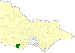 Location in Victoria | |||||||||||||||
| Population | 7,530 (1992)[1] | ||||||||||||||
| • Density | 4.832/km2 (12.515/sq mi) | ||||||||||||||
| Established | 1895 | ||||||||||||||
| Area | 1,558.39 km2 (601.7 sq mi) | ||||||||||||||
| Council seat | Cobden | ||||||||||||||
| County | Heytesbury | ||||||||||||||
 | |||||||||||||||
History
Heytesbury was originally located within the Hampden and Heytesbury Road District, which was incorporated on 28 April 1857. On 31 May 1895, Heytesbury split away from the East and West Ridings of the Shire of Hampden, to become a shire in its own right. On 6 May 1919, parts of its area split away to join parts of the Shires of Colac and Winchelsea, to form the Shire of Otway. Otway annexed a small part of Heytesbury in 1969.[2]
On 23 September 1994, the Shire of Heytesbury was abolished, and, along with the Town of Camperdown, the Shire of Hampden, and parts of the Shires of Colac, Mortlake and the area around Princetown, on the Great Ocean Road, was merged into the newly created Shire of Corangamite. A small part in the shire's east was transferred to the newly created Shire of Colac Otway.[3]
Wards
The Shire of Heytesbury was divided into three ridings, each of which elected three councillors:
- East Riding
- West Riding
- South Riding
Towns and localities
- Bostocks Creek
- Brucknell
- Bungador
- Carpendeit
- Cobden
- Cobrico
- Cowleys Creek
- Curdies River
- Curdie Vale
- Dixie
- Ecklin South
- Elingamite
- Glenfyne
- Jancourt
- Koallah
- Lower Heytesbury
- Newfield
- Pomborneit
- Port Campbell
- Scotts Creek
- Simpson
- Stoneyford
- Tandarook
- Tesbury
- Timboon
Population
| Year | Population |
|---|---|
| 1954 | 6,464 |
| 1958 | 6,800* |
| 1961 | 7,234 |
| 1966 | 8,181 |
| 1971 | 8,208 |
| 1976 | 7,902 |
| 1981 | 7,652 |
| 1986 | 7,487 |
| 1991 | 7,361 |
* Estimate in the 1958 Victorian Year Book.
References
- Australian Bureau of Statistics, Victoria Office (1994). Victorian Year Book. pp. 49–52. ISSN 0067-1223.
- Victorian Municipal Directory. Brunswick: Arnall & Jackson. 1992. p. 701. Accessed at State Library of Victoria, La Trobe Reading Room.
- Australian Bureau of Statistics (1 August 1995). Victorian local government amalgamations 1994-1995: Changes to the Australian Standard Geographical Classification (PDF). Commonwealth of Australia. p. 5. ISBN 0-642-23117-6. Retrieved 5 January 2008.