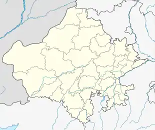
Sikar
Sikar is a city located midway between Agra and Bikaner on the National Highway 52 in the state of Rajasthan in India. It is the administrative headquarters of the Sikar District. Sikar is a historical city and contains many old havelis (large houses with Mughal-era architecture). It is located 114 km from Jaipur, 320 km from Jodhpur 215 km from Bikaner, and 280 km from Delhi.
Sikar | |
|---|---|
City | |
 Sikar Location in Rajasthan, India  Sikar Sikar (India) | |
| Coordinates: 27.62°N 75.15°E | |
| Country | India |
| State | Rajasthan |
| District | Sikar |
| Government | |
| • Type | Federal Republic |
| • Body | Government of Rajasthan |
| Area | |
| • Total | 26.57 km2 (10.26 sq mi) |
| Elevation | 427 m (1,401 ft) |
| Population (2020) | |
| • Total | 359,293 |
| • Rank | 6th |
| • Density | 14,000/km2 (35,000/sq mi) |
| Languages | |
| • Official | Hindi |
| • Regional | Rajasthani or Shekhawati |
| Time zone | UTC+5:30 (IST) |
| PIN | 332001 |
| Telephone code | 91-1572 |
| Vehicle registration | RJ-23 |
| Literacy | 81.25%(2nd) |
| Distance from Delhi | 280 kilometres (170 mi) (land) |
| Distance from Jaipur | 114 kilometres (71 mi) (land) |
| Website | www |
History
Sikar had been the biggest Thikana (Estate) of the Jaipur state. Previously Sikar was known as Shekhawati. It was the capital of Thikana Sikar. Sikar is surrounded by the fortified walls consisting of seven "Pols" (gates). These historic gates are named as Bawari gate, Fatehpuri Gate, Nani Gate, Surajpole Gate, Dujod Gate Old, Dujod Gate New and Chandpole Gate. The ancient name of Sikar was "Beer BhanKa Bass".
Geography and climate
Geography
Sikar is the district headquarters of Rajasthan's Sikar district, which is situated in the eastern part of Rajasthan. It is the sixth most populous city of Rajasthan. It is located at27.62°N 75.15°E.[1] It has an average elevation of 427 meters (1401 feet).
Climate
| Climate data for Sikar (1981–2010, extremes 1946–2009) | |||||||||||||
|---|---|---|---|---|---|---|---|---|---|---|---|---|---|
| Month | Jan | Feb | Mar | Apr | May | Jun | Jul | Aug | Sep | Oct | Nov | Dec | Year |
| Record high °C (°F) | 31.4 (88.5) |
37.4 (99.3) |
45.0 (113.0) |
45.5 (113.9) |
49.0 (120.2) |
49.7 (121.5) |
44.4 (111.9) |
41.1 (106.0) |
40.0 (104.0) |
41.0 (105.8) |
37.8 (100.0) |
32.5 (90.5) |
49.7 (121.5) |
| Mean maximum °C (°F) | 27.3 (81.1) |
30.4 (86.7) |
36.2 (97.2) |
41.9 (107.4) |
44.1 (111.4) |
44.7 (112.5) |
40.4 (104.7) |
37.4 (99.3) |
37.7 (99.9) |
37.4 (99.3) |
33.1 (91.6) |
28.6 (83.5) |
44.9 (112.8) |
| Average high °C (°F) | 22.2 (72.0) |
25.1 (77.2) |
30.9 (87.6) |
36.8 (98.2) |
39.8 (103.6) |
40.1 (104.2) |
35.4 (95.7) |
33.7 (92.7) |
34.5 (94.1) |
34.0 (93.2) |
28.5 (83.3) |
23.5 (74.3) |
32.1 (89.8) |
| Average low °C (°F) | 4.9 (40.8) |
8.0 (46.4) |
13.9 (57.0) |
19.5 (67.1) |
24.4 (75.9) |
26.2 (79.2) |
25.0 (77.0) |
24.4 (75.9) |
23.3 (73.9) |
17.9 (64.2) |
11.0 (51.8) |
6.0 (42.8) |
17.0 (62.6) |
| Mean minimum °C (°F) | 1.1 (34.0) |
3.9 (39.0) |
9.3 (48.7) |
13.9 (57.0) |
19.7 (67.5) |
21.5 (70.7) |
22.0 (71.6) |
21.9 (71.4) |
20.4 (68.7) |
13.6 (56.5) |
6.8 (44.2) |
1.8 (35.2) |
1.0 (33.8) |
| Record low °C (°F) | −3.0 (26.6) |
−4.2 (24.4) |
1.3 (34.3) |
7.0 (44.6) |
10.1 (50.2) |
11.9 (53.4) |
15.1 (59.2) |
16.9 (62.4) |
13.1 (55.6) |
5.4 (41.7) |
0.0 (32.0) |
−4.9 (23.2) |
−4.9 (23.2) |
| Average rainfall mm (inches) | 5.1 (0.20) |
7.7 (0.30) |
2.8 (0.11) |
4.5 (0.18) |
17.0 (0.67) |
50.7 (2.00) |
125.8 (4.95) |
95.5 (3.76) |
36.1 (1.42) |
9.6 (0.38) |
1.9 (0.07) |
1.8 (0.07) |
358.5 (14.11) |
| Average rainy days | 0.6 | 0.9 | 0.4 | 0.6 | 1.4 | 2.0 | 5.3 | 5.0 | 2.4 | 0.5 | 0.4 | 0.2 | 19.8 |
| Average relative humidity (%) (at 17:30 IST) | 50 | 41 | 36 | 33 | 35 | 39 | 58 | 60 | 52 | 38 | 38 | 42 | 44 |
| Source: India Meteorological Department[2][3] | |||||||||||||
Demographics
Sikar City has a population of about 237,579[4] people according to the census of 2011. As per provisional reports of Census India, the population of Sikar in 2011 is 237,579; of which there are approximately 123,156 males and 114,423 females. The sex ratio of Sikar City is 929 females per 1000 males. Regarding education, total literates in Sikar city are 158,413 of which 91,403 are males while 67,010 are females. The average literacy rate of Sikar City is 77.13, male and female literacy status is 86.29 and 67.37, respectively. The total population of children (0-6) in Sikar City is about 32,189, consisting of 17,236 boys and 14,953 girls. The child sex ratio of girls is 868 per 1000 boys.
Places of interest
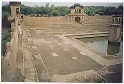
- Rajkumar Hardyal Singh Government Museum Sikar
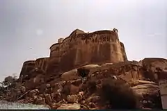
- Sikar Fort
- Sai Dham (Mundwara)
- Sri Digamber Jain Bada Mandir, Bawari Gate
- Madho Niwas Kothi
- Hameerpura haveli (Hameerpura)
- Hameerpura Purana Kunva,Bagichi (Hameerpura)
- Radha Damodar Mandir
- Bolta Balaji mandir
- Rani Mahal
- Devi Pura Balaji
- Shree Santoshi Mataji Mandir
- Ganesh Mandir, Fatehpuri Gate
- Temple of Gopinathji, Subhash Chowk
- Temple of Raghunathji, Bawari Gate
- Maroo Park
- Nehru Park
- Diwan Ji Ki Nashiya, Jatiya Bazar
- Diwan Ji ki Haveli
- Shobhagyavati mandir
- Shri Ram Hanuman mandir (Radha kishan pura Sikar)
- Shree Jeen Mataji Mandir
- Shree Shakambhari Mataji Mandir
- Dungari Ke Balaji Temple Puranbadi sikar
- Shyam Mandir Khatu
- Samolai Balaji Temple
- Deeppura Rajaji Fort
- Maa Durga Mandir Bhairupura Jagir
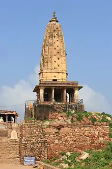
- Harshnath Mountain and temple
- Shree Mansa Mataji Mandir
Forts in Sikar District
- Devgarh Fort
- Laxmangarh Fort
- Raghunath Fort
- Danta Fort
- Ramgarh Fort
- Raiwasa Fort
- Badal Mahal Patan
- Roopgarh
- Shyamgarh
- Chota Pana Fort Khandela
- Ajitgarh
- Khachariyawas Fort
- Fatehpur Fort
- Khandela Bada Fort
- Mundru Fort
- Sirohi Sikar Fort
- Dansroli Fort Danta Ramgarh
- Ranoli Gadh
- Gadh Guhala Sikar
- Baral Fort Ranoli Sikar
- Dhod Fort
- Hameergarh (Hameerpura)
- Deeppura Rajaji Fort
- Aloda Fort
- Patoda Fort
- Kasalgarh
- Saladipura Fort
- Losal Citadel
- Sihot Badi Fort
- Bhathot Fort
- Garh Taknet
- Sujawas Fort
- Pachar Fort
- Vijaypura Fort Srimadhopur
- Ringas Fort Srimadhopur
- Thoi Fort
- Choukari Fort
- Garoda Fort
- Jajod Fort
- Surera Fort
- Khoor Fort
- Sami Fort
- Bajyawas Fort
- Singrawat Fort
- Singhasan Fort
Administration
Sikar city is governed by a Municipal Council, which comes under the Sikar Urban Agglomeration. The new municipal council building is built in Shekhawati style like a mahal or haveli. Sikar city is divided into 60 wards. Although Sikar city has a population of 237,579 (in 2011), its urban/metropolitan population is 244,563 (in 2011). The Sikar metropolitan area includes Chandrapura (Rural), Radhakrishnpura, Samarthpura, Shivsinghpura and Sikar city. The current Member of Parliament from Sikar is Swami Sumedhanand Saraswati elected in May 2014 and continue in May 2019. The District Magistrate and Collector of Sikar is Mr. Avichal Chaturvedi (2012) and Superintendent of Police is Dr. Gagan Deep Singla (2010).
Modes of transportation
Rail
Sikar Junction railway station comes within the territory of the North Western Railway. Sikar City is connected to Jhunjhunu, Rewari, Delhi, Churu, Bikaner, Sri Ganganagar, Hisar, Jaipur, Kota, Ajmer, Udaipur, Abu Road, Indore, Ahmedabad and Mumbai. And there is a new line proposal since 2010 of Sikar to Nokha via Sujangarh.
Road
Sikar is well connected by roads from all the major cities of Rajasthan and nearby states. A four-lane national highway NH-52 passes through the city. NH-52 connects Sikar with Jaipur and Bikaner. The western freight corridor also pass through Ringas of Sikar, as a main project of the central government. Kotputali Kuchaman Mega Highway also passes through Sikar.
Air
The nearest airport to Sikar City is Jaipur International Airport, which operates daily flights to Delhi, Mumbai, Hyderabad, Bangalore, Pune, Indore, Ahmedabad, Chennai, Guwahati, Kolkata, Udaipur, Dubai, Sharjah, and Muscat. A new airport is proposed at Shahpura (a town in Jaipur district) that is very close to Sikar. A small air strip at Tarpura village is also available for the landing of small private planes against payment.
Education
Sikar has become a major education hub of Rajasthan. Sikar is called Educational city of Rajasthan. there are maximum 1 lac student from other cities, villages and states who studies in Sikar. Along with numerous government colleges providing art, science, and commerce education, a number of private educational institutes have also opened up. It is known as Kota of northern half of Rajasthan.
Shri Kalyan Government College is the largest college and Sikar Medical College is the prominent medical college of Shekhawati.
Pandit Deendayal Upadhyaya Shekhawati University was opened in 2013 by the Rajasthan government. Sikar is also an emerging hub of coaching IIT-JEE and NEET.
Here some famous institutes provide coaching for engineering and medical exams. Some institutes are Allen, Matrix, Kautilya, GCI, CLC, Impulse, PCP, Samarpan, Swabhiman.[10] Sikar is the city which has IIT JEE Advance centre. Youth men (below 35) provide a major role in Indian defense services compared to other districts of Rajasthan.
Notable people
- Rao Raja Kalyan Singh Bahadur Maharaja of Sikar State 1922-1967
- Jamnalal Bajaj, founder of Bajaj Group
- Himani Shah, former Crown Princess of Nepal (birth in Sikar)
- Bhairon Singh Shekhawat, former vice president of India
- Mrs. Pratibha Patil, former first Woman President of India
References
- "Falling Rain Genomics, Inc a – Sikar". Fallingrain.com. Retrieved 29 December 2011.
- "Station: Sikar: Climatological Table 1981–2010" (PDF). Climatological Normals 1981–2010. India Meteorological Department. January 2015. pp. 715–716. Archived from the original (PDF) on 5 February 2020. Retrieved 29 December 2020.
- "Extremes of Temperature & Rainfall for Indian Stations (Up to 2012)" (PDF). India Meteorological Department. December 2016. p. M187. Archived from the original (PDF) on 5 February 2020. Retrieved 29 December 2020.
- "Census 2011 data – Sikar city". census2011.co.in. Retrieved 29 December 2011.
External links
| States | ||
|---|---|---|
| Union territories | ||
| Related topics |
| |
| Outline |
|  | |||||||||||||
|---|---|---|---|---|---|---|---|---|---|---|---|---|---|---|---|
| Governance |
| ||||||||||||||
| Divisions and districts |
| ||||||||||||||
| Major cities | |||||||||||||||
| Related templates |
| ||||||||||||||
