List of districts of Nagaland
Administration
A district of an Indian state is an administrative geographical unit, headed by a district magistrate or a deputy commissioner, an officer belonging to the Indian Administrative Service. The district magistrate or the deputy commissioner is assisted by a number of officials belonging to different wings of the administrative services of the state.
A superintendent of Police, an officer belonging to Indian Police Service is entrusted with the responsibility of maintaining law and order and related issues.
History
In 1957, the Naga Hills District district of Assam and Tuensang Frontier Division of the North-East Frontier Agency (now Arunachal Pradesh) were joined to form the centrally governed Naga Hills Tuensang Area. At that point the previous subdivisions became Kohima, Mokokchung and Tuensang districts. February 1961 saw the renaming of Naga Hills Tuensang Area to "Nagaland", and in December 1963 Nagaland became the 16th state of India.
December 1973 saw the new districts of Wokha and Zunheboto carved out of Mokokchung, Mon district carved from Tuensang district, and Phek district created out of Kohima district.[2]:8
In 1997 Dimapur district was carved from Kohima district.[3][4]
Three more districts were added in January 2004: Kiphire, Longleng and Peren.[5] Kiphire and Longleng districts were carved from Tuensang district, Peren district was carved from Kohima district.[6]
Noklak district was created on 21 December 2017, previously having been a sub-district of Tuensang district.[7]
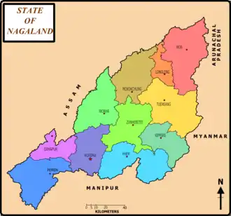
Districts
The twelve districts of Nagaland, and their capitals, 2011 census populations,[8] areas and elevations (of the seat) are:
|
|
- Including Noklak district
References
- "Districts of Nagaland". A Gateway to Districts of India on the Web. New Delhi: National Informatics Centre. Archived from the original on 3 March 2016. Retrieved 4 January 2013.
- "District Census Handbook Mokokchung" (PDF). Census of India. 2011. Archived from the original (PDF) on 14 November 2015.
- "Know Your Districts: Phek - The Morung Express". The Morung Express. 8 June 2016. Archived from the original on 6 June 2019. Retrieved 1 December 2017.
- "About Wokha". Wokha Dist Administration. 2010.
- Patra, S. C.; Vachhani, Ashish (2011). Socio-Economic Profile of Rural India (series II). Concept Publishing Company. p. 106. ISBN 9788180697241. Retrieved 6 August 2014.
- "Nagaland: Know Your Districts - An overview -III - The Morung Express". The Morung Express. 17 October 2017. Archived from the original on 20 May 2019. Retrieved 1 December 2017.
- "Noklak is Nagaland's youngest district". Eastern Mirror. 21 December 2017.
- "Primary Census Abstract". Office of the Registrar General & Census Commissioner, India. 2011.
Select State Nagaland, Select District All, Submit
External links
| States | ||
|---|---|---|
| Union territories | ||
| Related topics |
| |