List of districts of Kerala
The Indian state of Kerala borders with the states of Tamil Nadu on the south and east, Karnataka on the north and the Lakshadweep Sea coastline on the west. Western Ghats form an almost continuous mountain wall, except near Palakkad where there is a natural mountain pass known as the Palakkad Gap. When the independent India amalgamated small states together Travancore and Cochin states were integrated to form Travancore-Cochin state on 1 July 1949. However, Malabar remained under the Madras province. The States Reorganisation Act of 1 November 1956 elevated Kerala to statehood.
| Districts of Kerala | |
|---|---|
 Districts of Kerala | |
| Category | Districts |
| Location | Kerala |
| Number | 14 districts |
| Populations | Wayanad – 846,637 (lowest); Malappuram – 4,494,998 (highest) |
| Areas | Alappuzha – 1,415 km2 (546 sq mi) (smallest); Palakkad – 4,482 km2 (1,731 sq mi) (largest) |
| Government | Government of Kerala |
| Subdivisions | Revenue Divisions of Kerala |
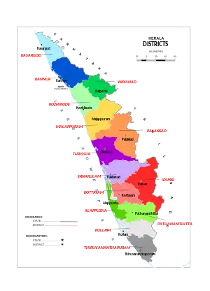
The state of Kerala is divided into 14 revenue districts. On the basis of geographical, historical and cultural similarities the state's districts are generally grouped into three parts – The North Kerala districts of Kasaragod, Kannur, Wayanad, Kozhikode, Malappuram; the Central Kerala districts of Palakkad, Thrissur, Ernakulam, Idukki; and the South Kerala districts of Kottayam, Pathanamthitta, Alappuzha, Kollam, Thiruvananthapuram.[1] Such a regional division occurred being part of historical Kingdoms of Kochi, Travancore and British Province of Malabar. The Travancore region was again divided into three zones as Northern Travancore (Hill Range) (Idukki and parts of Ernakullam), Central Travancore (Central Range) (Pathanamthitta, Alappuzha and Kottayam) and Southern Travancore (Southern Range) (Thiruvananthapuram and Kollam). The Malabar region was divided into North Malabar and South Malabar. The districts in Kerala are often named after the largest town or city in the district. The 14 districts are further divided into 77 taluks, 6 Municipal Corporations, 87 Municipalities, and 941 Gram panchayats. Some of the districts were renamed in 1990 from the anglicised names to their local names.
Administrative structure
Kerala State has been divided into 14 districts, 77 taluks, 152 community development blocks, 941 Gram panchayats, 6 corporations and 87 municipalities.
A district is governed by a District Collector, who is an officer from Indian Administrative Service (IAS) of Kerala cadre and is appointed by the State Government of Kerala. Functionally the district administration is carried on through the various Departments of the State Government each of which has an office of its own the district level. The District Collector is the executive leader of the district administration and the District Officers of the various Departments in the district render technical advice to him in the discharge of his duties. The District Collector is a key functionary of Government having large powers and responsibilities. He has a dual role to both as the agent of the Government of the state and also as the representative of the people in the district. He is also responsible for the maintenance of the law and order of the district.
Other than urban units such as town municipalities and rural units called Gram panchayats, other government administrative subdivisions includes taluks and 'community development blocks' (also known as CD blocks or blocks). A taluk consists of urban units such as census towns and rural units called gram panchayats. The Tahsildar in charge of each taluk is primarily the Revenue Official responsible for the collection of revenue of the taluk, but he is also expected to be in direct contact with the people at all levels and to have first hand knowledge of the conditions of every village under his jurisdiction. The Tahsildar is assisted in each village by village officers and village assistants. A block also consists of such as census towns and Gram panchayats. A block is administered by a Block Development Officer (BDO), who is appointed by the Government of Kerala. A gram panchayat, which consists of a group of villages, is administered by a village council headed by a Gram Panchayat President.
A District Superintendent of Police, better known as a Superintendent of Police, heads the District Police organization of Kerala Police. This is as per the Police Act of 1861, which is applicable to the whole of India. The Superintendents of Police are officers of the Indian Police Service. For every subdivision, there is a Subdivision Police, headed by a Police officer of the rank of Assistant Superintendent of Police or Deputy Superintendent of Police. Under subdivisions, there are Police Circles, each headed by an Inspector of Police. A Police Circle consists of Police Stations, each headed by an Inspector of Police, or in case of rural areas, by a Sub-Inspector of Police.
The Kerala High Court has the jurisdiction of the state of Kerala. Each of the districts has a District Court.
History
At the time of formation, Kerala had only five districts: Malabar (part of the erstwhile Madras State), Thiruvananthapuram, Kollam, Kottayam and Thrissur (together constituting the erstwhile Travancore-Cochin). On 1 January 1957, the Malabar district was trifurcated to form new districts of Kozhikode, Palakkad, and Kannur. Alappuzha district was carved out of erstwhile Kottayam and Kollam districts on 17 August 1957. Ernakulam district was formed on 1 April 1958, carving out of parts of erstwhile Thrissur and Kottayam districts. Malappuram district was formed on 16 June 1969 with Ernad and Tirur taluks of the erstwhile Kozhikode district and Perinthalmanna and Ponnani taluks of Palakkad district. Idukki district was formed on 26 January 1972 with Devikulam, Udumbanchola and Peermedu taluks of the erstwhile Kottayam district and Thodupuzha taluk of the erstwhile Ernakulam district. Wayanad district was formed on 1 November 1980 as the 12th district in Kerala by carving out areas from Kozhikode and Kannur districts. Pathanamthitta district was formed on 1 November 1982 carving out the entire Pathanamthitta taluk and nine villages of Kunnathur taluk from Kollam district, entire Thiruvalla taluk and part of Chengannur and Mavelikkara taluks from Alapphuzha district and parts of Idukki district. Kasaragod district was formed on 24 May 1984 as the 14th revenue district by carving out a major portion of the erstwhile Kannur district.
Alphabetical listing
| Code[2] | District | Headquarters[3] | Established[4] | Population (2018)[5] | Area[6] | Subdivisions | Location |
|---|---|---|---|---|---|---|---|
| AL | Alappuzha | Alappuzha | 17 Aug 1957[7] | 2,146,033 | 1,415 km2 (546 sq mi) | 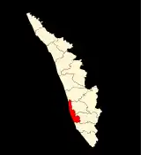 | |
| ER | Ernakulam | Kakkanad | 1 Apr 1958[8] | 3,427,659 | 3,063 km2 (1,183 sq mi) | 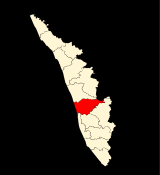 | |
| ID | Idukki | Painavu | 26 Jan 1972[10][11] | 1,093,156 | 4,356 km2 (1,682 sq mi) | 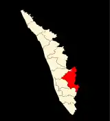 | |
| KN | Kannur | Kannur | 1 Jan 1957[12] | 2,615,266 | 2,961 km2 (1,143 sq mi) | 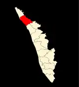 | |
| KS | Kasaragod | Kasaragod | 24 May 1984[13][14] | 1,390,894 | 1,989 km2 (768 sq mi) | 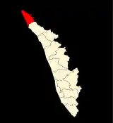 | |
| KL | Kollam | Kollam | 1 Nov 1956[16] ( 1 July 1949)[17][18] |
2,659,431 | 2,483 km2 (959 sq mi) | 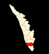 | |
| KT | Kottayam | Kottayam | 1 Nov 1956[20] (1 July 1949 )[17] |
1,983,573 | 2,206 km2 (852 sq mi) | 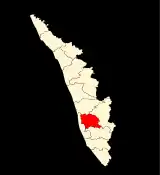 | |
| KZ | Kozhikode | Kozhikode | 1 Jan 1957[22] | 3,249,761 | 2,345 km2 (905 sq mi) |  | |
| MA | Malappuram | Malappuram | 16 Jun 1969[24] | 4,494,998 | 3,554 km2 (1,372 sq mi) | 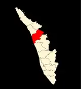 | |
| PL | Palakkad | Palakkad | 1 Jan 1957[25] | 2,952,254 | 4,482 km2 (1,731 sq mi) | 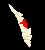 | |
| PT | Pathanamthitta | Pathanamthitta | 1 Nov 1982[27][28] | 1,172,212 | 2,652 km2 (1,024 sq mi) | 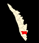 | |
| TV | Thiruvananthapuram | Thiruvananthapuram | 1 Nov 1956[30] (1 July 1949)[17] |
3,355,148 | 2,189 km2 (845 sq mi) | 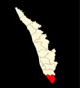 | |
| TS | Thrissur | Thrissur | 1 Nov 1956[31] (1 Jul 1949)[17] |
3,243,170 | 3,027 km2 (1,169 sq mi) |  | |
| WA | Wayanad | Kalpetta | 1 Nov 1980[32] | 846,637 | 2,130 km2 (820 sq mi) | 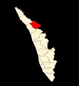 | |
| Total | 14 | 14 | 14 | 34,630,192 | 38,852 km2 (15,001 sq mi) | 77 |
See also
References
- "Divisions of Kerala". kerala.gov.in. Retrieved 18 August 2020.
- "NIC Policy on format of e-mail Address: Appendix (2): Districts Abbreviations as per ISO 3166–2" (PDF). Ministry Of Communications and Information Technology, Government of India. 10 August 2004. pp. 5–10. Archived from the original (PDF) on 11 September 2008. Retrieved 24 November 2008.
- "Districts : Kerala". Government of India portal. Retrieved 11 March 2009.
- Here 'Established' means the year of establishment as a district of Kerala. If the district was formed earlier than the formation of the state of Kerala, 1 Nov 1956 will be considered as the day of establishment of the district.
- Annual Vital Statistics Report - 2018 (PDF). Thiruvananthapuram: Department of Economics and Statistics, Government of Kerala. 2020. p. 55.
- "Part I: state" (PDF). Government of India Census portal. Retrieved 8 December 2015.
- "Alappuzha : History". alappuzha.nic.in. Archived from the original on 10 April 2009. Retrieved 11 March 2009.
- "History of Ernakulam". ernakulam.nic.in ( Ministry of Communication & Information Technology, Govt. of India). Archived from the original on 15 November 2007. Retrieved 11 March 2009.
- "Taluks — Ernakulam District". ernakulam.nic.in. Archived from the original on 27 February 2009. Retrieved 11 March 2009.
- "IDUKKI : History". idukki.nic.in ( Ministry of Communication & Information Technology, Govt. of India). Retrieved 11 March 2009.
- as per Government notification No 54131/C2/71/RD dated 24 January 1972, Government of Kerala
- "Kannur district : Administration". knr.kerala.gov.in ( Govt. of Kerala). Archived from the original on 21 April 2009. Retrieved 11 March 2009.
- "DISTRICT CAME INTO EXISTENCE..." kasargod.nic.in. Archived from the original on 10 April 2009. Retrieved 11 March 2009.
- As per GO.(MS)No.520/84/RD dated 19.05.1984, Government of Kerala
- "Kasaragod District > taluks". kasargod.nic.in. Retrieved 11 March 2009.
- "Short History of Kollam". kollam.nic.in. Archived from the original on 18 May 2011. Retrieved 11 March 2009.
- Note: This date means the day when the district was initially formed, even before the formation of the state of Kerala. Hence 1 Nov 1956 will be considered as the day of formation of district in the state of Kerala
- Paravur, Kollam
- "Taluks and Villages". Kollam.nic.in. Archived from the original on 10 February 2007. Retrieved 11 March 2009.
- "District Handbooks of Kerala KOTTAYAM" (PDF). kerala.gov.in. Archived from the original (PDF) on 19 March 2009. Retrieved 11 March 2009.
- "KOTTAYAM : Short History". Kerala.gov.in. Retrieved 12 March 2009.
- "Kozhikode: History". kozhikode.nic.in. Archived from the original on 2 April 2007. Retrieved 12 March 2009.
- "Kozhikode: Administration". kozhikode.nic.in. Archived from the original on 7 February 2009. Retrieved 12 March 2009.
- "Malappuram: HISTORY". malappuram.nic.in. Retrieved 12 March 2009.
- "Welcome to Palghat". palghat.net. Retrieved 12 March 2009.
- "BASIC STATISTICS of PALAKKAD". palakkad.nic.in. Archived from the original on 10 April 2009. Retrieved 12 March 2009.
- "Pathanamthitta : History". pathanamthitta.nic.in. Archived from the original on 10 April 2009. Retrieved 12 March 2009.
- As per GO (MS) No.1026/82/(RD) dated 29.10.1982, Government of Kerala
- "Pathanamthitta : Administration". pathanamthitta.nic.in. Archived from the original on 10 April 2009. Retrieved 12 March 2009.
- "THIRUVANANTHAPURAM". Archived from the original on 7 February 2009. Retrieved 12 March 2009.
- "Thrissur At A Glance". thrissur.nic.in. Retrieved 12 March 2009.
- "Wayanad :profile". wayanad.nic.in. Retrieved 12 March 2009.
External links
| Wikimedia Commons has media related to Districts of Kerala. |
| States | ||
|---|---|---|
| Union territories | ||
| Related topics |
| |
Kerala topics | |||||||||||||
|---|---|---|---|---|---|---|---|---|---|---|---|---|---|
| History | |||||||||||||
| Government Politics |
| ||||||||||||
| Incidents | |||||||||||||
| Geography | |||||||||||||
| Demographics Economy Religion | |||||||||||||
| Culture |
| ||||||||||||
| Tourism | |||||||||||||