Timeline of Baltimore to 1799
The following is a timeline of the history of the city of Baltimore, Maryland, (United States) up to 1799. For later, see Timeline of Baltimore.
| History of Maryland |
|---|
|
|
|
- 1608 – Captain John Smith, (c.1580-1631), sails north up Chesapeake Bay from the newly established Virginia colony at Jamestown, settled on the James River the year before, and records in his journal, first descriptions of the area that would become the future site of the city of Baltimore, then a hunting ground for local American natives. Smith records in his map and journal "a river not inhabited yet navigable", which he names the "Bolus Flu" for the reddish soil with iron ore found – Indians who hunt in the region call it the "Patapsco".
- 1624 - Sir George Calvert, (1579-1632), resigns office of King James I's Secretary of State, for the Kingdom of England and announces himself as converted to the minority, formerly outlawed faith of Roman Catholicism, and withdraws from public life. He received the title of nobility as Baron Baltimore ("Lord Baltimore") as a sign of personal friendship and gratitude from the English Monarch. He is added to the Irish peerage for the town of Baltimore, in the western half of County Cork in the province of Munster on the southern coast tip of Ireland, which England dominates. He will be succeeded by descendants of five more "Lord Baltimores" until title is extinguished in 1771 with the death of the sixth and last, Frederick Calvert.
- 1632 – After an unsuccessful attempt by Calvert to found an English colony in Avalon in Newfoundland (today's eastern Canada), a second Charter is granted to a colony further to the south in a more temperate climate by King Charles I of England to Sir George Calvert, (1579-1632), First Lord Baltimore, his father was King James I's former Secretary of State and respected friend of the monarch. This second grant is named "Maryland" for the King Charles's wife and Queen Consort Henrietta Maria of France, (1609-1669), and is laid out with straight but irregular inexact boundaries along the eastern and western shores of the Chesapeake Bay, north of the earlier 1607 colony of Virginia, above the separating Potomac River, and south and west of the Delaware River and Bay. Bordering the Swedish (New Sweden) and Dutch colonies of New Netherland, to the northeast and to keep them from moving south from the town of New Amsterdam with its Fort Amsterdam (modern New York City) along the Hudson River. These lay in between and south of other extensive English colonies settled beginning 1620 in New England, such as Massachusetts Bay, Plymouth, Boston and Connecticut colonies.
- 1634 – The Ark and The Dove, ships of George's eldest son, the second Lord Baltimore Cecilius Calvert's (1605-1675), first colonizing expedition, led by his younger brother Leonard Calvert, (1606-1647), (sent as first provincial governor), land on March 25th (later celebrated as an official state holiday, "Maryland Day") at Blakistone Island (St. Clement's Island) off the north shore of the Potomac River, bringing the first European settlers and African slaves to the new colonial Province of Maryland,
- 1650 – "Ann Arundell" County "erected" (established) further north along the western shore of the Chesapeake Bay near St. Mary's City along the Potomac River. Named for Lady Ann Arundell, [antique spelling different from modern], (1615/1616-1649), wife of Cecilius Calvert, second Lord Baltimore.
- 1659 – Baltimore County established in the northeast section of the Province, north of previous Anne Arundel County laid out nine years before, which it is cut from. Includes what is now Baltimore City, Baltimore County, Harford and Cecil counties. Officeholder of Sheriff for Baltimore County first designated in legal papers from the General Assembly is mentioned in writing for serving of legal papers.
- 1661 – First court sits for Baltimore County, meeting at Captain Thomas Howell's place in what is now modern Cecil County in the far northeast corner of the province.
- Charles Gorsuch, a Quaker, patents 50 acres of land on narrow jagged peninsula which juts out between two branches into the main lower Patapsco River, ending in "Whetstone Point". He promises to pay Lord Baltimore, the amount of 61 English pounds sterling per year for the use of the land.
- David Jones hires Peter Carroll to survey 380 acres along the stream which is later named "Jones Falls" in his honor. He built a house and is known as Baltimore's first settler.
- 1663 – Alexander Mountenay patented land named "Mountenay's Neck" along the Harford Run stream, where Central Avenue, formerly Canal Street, is now paved over in old east Baltimore's Jonestown and which is later sold and resurveyed to William Fell.
- Land is patented along Curtis Bay and Curtis Creek southwest off the lower Patapsco River estuary to Paul Kinsey naming it "Curtis's Neck".
- 1664 – Capt. Thomas Todd purchases land at North Point, end of the "Patapsco Neck" peninsula (in southeastern Baltimore County), between the Back River and the Patapsco's north shore, followed by John Boring, merchant in 1679.
- 1668 – Thomas Cole takes up 550 acres of property named "Cole's Harbor" in future site of northern Baltimore Town and combines it with "Todd's Range" along the "Basin" (later Inner Harbor) waterfront on the Northwest Branch of the Patapsco.
- "Timber Neck" parcel (stretching along future Howard, Paca and Eutaw Streets of westside downtown Baltimore), patented by John Howard.
- 1673/74 – Cecil County formed from northeastern portion of Baltimore County and temporarily includes future Kent County on the upper Eastern Shore of the Chesapeake.
- 1683 – First mention in records for Baltimore County of a "county seat" with a "port of entry" designated by the General Assembly on the Bush River, later called "Old Baltimore".
- 1692 – "Patapsco Hundred" Parish of the established (official) Church of England established for Baltimore County near Colgate Creek on the "Patapsco Neck" peninsula. Later Parish is named as St. Paul's Church or Parish (of the "Anglican" Church) with small log building erected. One of the authorized "Original Thirty" parishes designated in the Province. Oldest church and congregation in greater Baltimore area and one of the oldest in the state.
- 1693 – Gov. Francis Nicholson (1693-1699) orders that a "garrison" or stone blockhouse be built in western reaches of Baltimore County (near modern community of Owings Mills) on what was Capt. Risteau's plantation. Built of stone, twenty by fifty feet, with a fireplace and small embrasures for musketry. The blockhouse is manned by one captain and nine soldiers. Fort Garrison now considered as the oldest colonial fort in Maryland and one of those in America.
18th century
1700s–1740s
- 1704 – Provincial law requires that enough trees be cut down to widen the main roads to twenty feet and that roads be marked. Marking system consists of cutting slashes in tree trunks: one vertical slash on a road leading to a church and three horizontal lines, two close together and one a bit higher on roads leading to a county courthouse.
- 1706 – Port of Baltimore established as an authorized for shipping of tobacco and other products by colonial General Assembly of the Province of Maryland for the upper Chesapeake Bay region at the head of the Patapsco River's Northwest Branch, in "The Basin" (now called "Inner Harbor"), west of inlet and small island at the mouth of the "Jones Falls" stream and "Harford Run" (later covered by Central Avenue in the 19th century) further to the east, both of which flow from the north, and a small stream flowing from the west, later called "Uhler's Run". Situated below the jagged cliff heights (later known after 1788 as "Federal Hill") to the south which overlook the protected harbor which has a twelve-foot depth, enough for ocean-going sailing ships, along a narrow peninsula (old South Baltimore) leading to Whetstone Point. Although only a few ships make anchor the first years by Whetstone Point, it never grows into a town as did deeper anchorages further upstream at future Fells Point and Baltimore Town.
- 1711 – Charles Carroll of Annapolis, (1702–1782), sells 31 acres to Jonathan Hanson who erects a mill, probably the first along the Jones Falls in the vicinity of the intersection with later-day Holliday Street.
- 1715 – General Assembly of the colonial Province of Maryland authorizes convening of a Court to serve the growing numbers of residents – farmers, merchants, mechanics, shipbuilders in northeastern Maryland which is now called "Baltimore County", since 1659 and sets four sessions per year for the Court on the first Tuesday of March, June, August and November.
- 1723 – Capt. Robert North takes up residence in the County and is one of the original lot owners. He commands the ship "Content " which he carries in freight this year.
- 1726 – Richard Gist lays out future port community for Edward Fell called "Fell's Prospect", and surveys three dwellings, several tobacco houses, an orchard and a mill – Jonathan Hanson's. Fell builds a store, and the area eventually came to be called "Fell's Point". Edward Fell's brother William, a carpenter arrives from Lancashire, England in 1730 and purchases 100 acres named "Copus Harbor" at "Long Island Point" (vicinity of modern Lancaster Street, near Philpot Street – east of Jones Falls mouth – today's "Harbor East and new developments at "Harbor Point" in 2013) and builds house and shipyard.
- 1728 – John Cockey (whose brother Thomas purchased property in "Limestone Valley" on the York Road up in central Baltimore County giving his name to the future Cockeysville) purchases land near the Patapsco.
- 1729 – County citizens petition the colonial General Assembly to establish a Town for the ease of exporting tobacco and importing goods from overseas and further expanding the 1706 Port and Harbor. Original site planned and designated was on north shore of the Patapsco's "Middle Branch" (also known as "Ridgeley's Cove") owned by John Moale, a merchant from Devonshire, England who later objected to the site of the new Town, believing that valuable iron ore deposits were located there. So the first commissioners appointed – ("Gentlemen of Consequence": Thomas Tolley, William Hamilton, William Buckner, Dr. George Walker, Richard Gist, Dr. George Buchanan, and William Hammond) instead purchased to the northeast, 60 acres of land of Charles Carroll's "Cole's Harbor/Todd's Range" along the north side of the future "Basin" (Inner Harbor) at the head of the Northwest Branch of the Patapsco River from Daniel (1696–1751), and Charles Carroll of Annapolis, (1702–1782) and county surveyor Philip Jones plans to lay out three streets: Calvert, Forest (later called Charles) which ran north to south, and the east-west Long or later called Market (after the 1760s and still later further as East and West Baltimore) Street. "The Town of Cecilius Calvert, Lord Baltimore" was then founded with the sole resident of the area at the time: John Fleming (whose house stood near southeast corner of Forest (future South Charles) and King George (later East Lombard) Streets).
- 1730 – The "Original Survey" taken on January 12, and 60 one-acre lots were laid out by County Surveyor Philip Jones beginning at an oak tree located then at present site of Forest (South Charles) and future Camden Streets. Three streets laid out and confirmed: Calvert, Forest (Charles), and Long (later renamed Market, then Baltimore Street), with smaller streets/alleys: Hanover, German and Water Streets with "Great Eastern Road" running along the northwest edge of the new town connecting with Philadelphia, 90 miles to the northeast, and with Georgetown, Maryland on the Potomac River to the southwest and the provincial capital town of Annapolis to the south (colonial capital since 1694). Southwestern village boundary is along "Uhler's Run" stream – later Uhler's Alley, – southwest of Forest and King George Streets (later South Charles and West Lombard Sts.). Waterfront shoreline to the south with first wharves located along riverside of "The Basin" (later Inner Harbor) at German and Water Streets (at approximate site of modern Redwood/Water Streets – three blocks further north of modern (2019) shoreline/"Harborplace"). "Steiger's Meadow" (northeast of town) and "Harrison's Marsh" (east of town) were along the west bank of the Jones Falls stream to the east of new Town. Charles Carroll of Annapolis as owner of the property has first choice and chooses Lot #49 at Calvert Street and the Basin, Philip Jones, the surveyor picks Lot #37 on the Basin at the foot of Charles Street. Sixteen men take up lots that first day, many along the waterfront. Process continues over the next few years with some later forfeiting their claim for not building within eighteen months. Ten years later some lots are still held by the town commissioners – so not exactly a boom town right off.
- St. Paul's Anglican Parish, of the "established" (colony-supported) Church of England, established earlier in 1692 as one of "Original Thirty" parishes in the colonial Province of Maryland, is moved from a rough church structure near Colgate Creek on the "Patapsco Neck" peninsula (near modern Dundalk and Sea Girt Marine Terminals of the Port of Baltimore, which had been site of old Harbor Field and Baltimore Municipal Airport in the 1930s and 40s), between the lower Patapsco and Back Rivers to the southeast of Baltimore County. Later a year after establishment of the new town, the Vestry (congregation council) of St. Paul's Parish purchases Lot #19 at southeast of Forest Street (later North Charles Street) and large lot extends to the east to St. Paul's Lane (later St. Paul Street/Place/"Preston Gardens") overlooking rugged cliffs above Jones Falls loop to the southwest before turning north again, with south lot boundary line extending to New Church Lane (later East Lexington Street – renamed after American Revolution – later vicinity known as North Charles and East Saratoga Streets). Construction of church as first brick building in town begins the following year.
- 1731 – Baltimore Ironworks Company formed by Daniel Dulany the Elder, Benjamin Tasker, Sr., and members of the Carroll family: Dr. Charles Carroll, Charles Carroll, Esq., and Daniel Carroll who establish iron ore pits, furnace works and export through Baltimore and Fells Point.
- 1732 – "Jones's Town", a tract of ten acres of 20 lots along four streets (also later called "Old Town" by the 19th century) laid out by county surveyor Philip Jones for relative David Jones; established along northeast bank of Jones Falls which flows into the Patapsco's Northwest Branch, east of "The Basin".
- 1739 – First brick building completed in town built for church for "Old St. Paul's Anglican Parish" at Forest (Charles) Street and Fish Lane (later East Saratoga Street) on northern edge of town perched on cliffs to the east overlooking St. Paul's Lane (now Street/Place) and the Jones Falls loop using 600,000 bricks newly manufactured in Baltimore by Charles Wells. Building faces future Lexington Street side to the south and Lower Town. Cemetery laid out around church building. New Church Street laid out south of new church building (later renamed Lexington Street after American Revolution).
- 1740 – Methodist itinerant preacher and missionary George Whitefield (1714–1770), preaches here inspired by evangelical "First Great Awakening" religious revival meetings and Church of England ministers John Wesley (1703–1791), and Charles Wesley (1707–1788).
- 1741 – First brick house built in town for Edward Fortrell from Ireland with free-stone corners, two stories high with peaked roof at northwest corner of Calvert Street and Fish Lane (later East Fayette Street). Later site of large sumptuous James Buchanan mansion/townhouse of 1799 – later sold to noted U.S. Senator Reverdy Johnson, (1796–1876), and ransacked in 1835 during infamous Baltimore bank riot, also future site of southeast corner of 1894–1900 Baltimore City/Clarence M. Mitchell, Jr. Courthouse, opposite future Courthouse/Battle Monument Square.
- 1745 – Merger of "Jones's Town" (later also known as "Old Town") and "Baltimore Town" authorized on September 28th by General Assembly of Maryland enlarges the original settlement on the Northwest Branch of the Patapsco River with an important wooden bridge constructed at Bridge Street (later named Gay Street) connecting the two, crossing the Jones Falls stream (flowing south from upper Baltimore County and Pennsylvania) and the adjacent "Harrison's Marsh" (on land of Thomas Harrison) to the south and "Steiger's Meadow" to the northwest by the "Loop" of the Jones Falls flowing from the north to southwest, with then turning northeast, then continuing further south to drain into the Patapsco River's "Basin" at the head of its Northwest Branch, separating the two villages. The merged two villages are now according to the Assembly's Act to be called "Baltimore Town".
- 1746 – Town Commissioners hire Capt. Robert North to build fence around former Jones's Town area and then follow two years later with a subscription by townspeople to build post and fence around Baltimore Town and keep in repair, prohibiting raising hogs and geese, with three gates – one at west end of Long Street (later known as Market Street, then Baltimore Street), one at the upper part of Bridge Street (later renamed Gay Street) over the Jones Falls and a third smaller portal near the north end of Charles Street near old St. Paul's Anglican Church for foot passengers, completed 1750. Unfortunately, the next few winters are severe and scavengers strip pieces for winter firewood and by 1752, fence remnants are sold off as lumber.
- 1747 – Act of the Maryland General Assembly on July 11th, authorized the addition of 18 acres that lay to the east of the edge of Town and between the west bank of the Jones Falls, including the then named "Harrison's Marsh" of Thomas Harrison, later memorialized by the naming of Harrison Street in the vicinity, which existed until the 1980s, going north-south between Frederick Street and the stream. First of many future annexations and growth of the Town/City's jurisdiction into the surrounding Baltimore County, prompted by the earlier merger with Jones's Town two years before on the eastern bank of The Falls. Nicholas Ruxton Gay does the surveying and in turn Bridge Street and the wooden bridge spanning Jones Falls uniting Old Baltimore Town with its eastern neighbor of Jones Town is renamed for him. Over the following two centuries, several bridges are built for Gay Street over the Falls until it is diverted into underground conduits in 1913-1914. It is extended several miles through various future neighborhoods of East Baltimore to the northeast edge of the 1818 old city limits at Boundary Avenue (later renamed East North Avenue) and changes over to Belair Road (later designated U.S. Route 1 in the 1920s), leading to the county seat town of Bel Air in Harford County.
- Town's first attempt to deal with the flimsy wooden structures of the era and constant threat of conflagration was in July, with provisions regarding fire prevention was added to the Act enlarging the town boundaries. Housekeepers were to be subject to a ten shilling fine if they do not "keep a ladder high enough to extend to the top of the roof of such house or if their chimneys blaze out" was another order of the town commissioners and that if a fire does break out, for all to grab a bucket and come running. At night, two men were to lead the way, one carrying a torch and the other blowing a fog horn.
- Seven ships have called at the growing Port of Baltimore this year, with fifteen arriving the following year (1748), all bound for London.
- 1749 – First recorded fire in Baltimore Town on March 16, at the home of Greenbury Dorsey, at an unrecorded location. Unfortunately, one man, four children and "one colored girl" were burned to death.
1750s–1790s
- 1750 – First German Reformed Church organized. Second oldest Protestant congregation in town. Invites Rev. John Christian Faber to become their pastor in 1756 and begin building a structure just north of Old St. Paul's Anglican Church (Church of England) on Forest (North Charles) Street, with some Evangelical Lutherans from Germany worshipping with them. Congregation later moves to Front Street at East Baltimore Street by Jones Falls east bank, but structure damaged by flood before completion – help to finish building given by ministers of other local churches – Anglican, Presbyterian and Lutheran. Later landmark building surmounted by tall steeple and prominent "town clock". This First German Reformed congregation later relocates in 1928 to York Road (Maryland Route 45) n Rodgers Forge/Stoneleigh/Anneslie (in northern suburbs) and merges with more prosperous daughter church – St. Stephen's, becoming known as First and St. Stephen's in the Evangelical and Reformed Church – later the United Church of Christ national denomination after its 1957 merger.
- Additional 25 acres of land added to the Town, north and east of the former Jones' Town, east of the Jones Falls.
- Beginning of a several years-long controversy with the Town Commissioners ordering on February 6, that citizens provide themselves with ladders high enough to reach the tops of their roofs before the next month of March. By the following year when seeing not all residents were sufficiently supplied because of living in rented quarters, the board ordered the clerk to place advertisements applying the requirement to landlords also.
- 1751 – Subscription and lottery attempt fails to build public market house for Baltimore Town. But successful twelve years later by 1763 at northwest corner of Long Street (later Market, then Baltimore Street) and Bridge Street (later Gay Street). Replaced by later Centre ("Marsh") Market in 1782 at Market (East Baltimore) Street and Market Place/Harrison Street by west bank of Jones Falls, and supplemented by other markets in western precincts (Lexington Market) and eastern precincts (Broadway Market in Fells Point) by 1784.
- Further sanitary regulations promulgated by the town commissioners: "Whereas several persons permit stinking fish, dead creatures or carrion to lie on their Lotts or in the Streets near their doors which are very offensive Nuisances and contrary to Act of Assembly, the Commissioners therefore Order the Clerk to put up advertisements to inform such Persons that they are to remove them ..."
- 1752 – First Census taken of Baltimore Town lists 30 names of settlers, first census of surrounding Baltimore County enumerates free whites – 11,345, white servants and convicts – 1,501, black and mulatto slaves − 4,143, free blacks and mulattos – 204.
- First historic illustration drawing of the new Town by John Moale (1731–1798, son of man who had objected to original laying out town site on upper Middle Branch/Ridgley's Cove of Patapsco River), showing approximately 25 houses – four of brick, one brick church, two taverns (Payne's and Kaminsky's – on corner of future Grant and Mercer Streets alleys in the block bounded by modern German/Redwood, Light, Water and South Calvert Streets, endures as wooden frame structure with "Dutch" hipped roof, tavern later raised higher on stone foundation which becomes ground/first floor until photographed and razed in 1870), one brewery (Barnetz Brothers), one tobacco inspection warehouse, one wharf, a barber shop and an insurance office. The country-like view, with its few buildings and rolling hills and forests of topography was taken looking north from the overlook on rugged cliffside heights (called "John Smith Hill" since 1608 and later named Federal Hill after 1788 and surrounding neighborhood by early 1800s), to the south of "The Basin" (later called the "Inner Harbor").
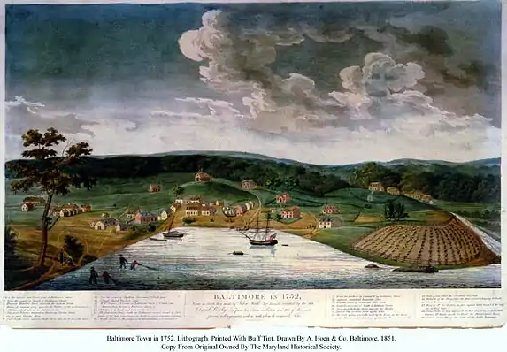 Baltimore in 1752. Engraved in 1851 by William Strickland, from then contemporary sketch by John Moale [jr.], (1731–1798)
 - School first organized by Mr. James Gardner at South and Second (later Water) Streets along harbor north shoreline.
- First historic illustration drawing of the new Town by John Moale (1731–1798, son of man who had objected to original laying out town site on upper Middle Branch/Ridgley's Cove of Patapsco River), showing approximately 25 houses – four of brick, one brick church, two taverns (Payne's and Kaminsky's – on corner of future Grant and Mercer Streets alleys in the block bounded by modern German/Redwood, Light, Water and South Calvert Streets, endures as wooden frame structure with "Dutch" hipped roof, tavern later raised higher on stone foundation which becomes ground/first floor until photographed and razed in 1870), one brewery (Barnetz Brothers), one tobacco inspection warehouse, one wharf, a barber shop and an insurance office. The country-like view, with its few buildings and rolling hills and forests of topography was taken looking north from the overlook on rugged cliffside heights (called "John Smith Hill" since 1608 and later named Federal Hill after 1788 and surrounding neighborhood by early 1800s), to the south of "The Basin" (later called the "Inner Harbor").
- 1753 – Influential citizens John Stevenson, Richard Chase, John Moale, William and Nicholas Rogers, John Ridgely, Nicholas Ruxton Gay, William Lux (son of Darby Lux I) and Brian Philpot manage lottery to raise money for building additional public wharf.
- 1754 – Mount Clare Mansion begins construction on what is originally called "Georgia Plantation" estate, north of Gwynns Falls stream, northwest of "Ridgeley's Cove" on Ferry Branch (later known as Middle Branch) of Patapsco River and southwest of growing Baltimore Town laid out in 1729-1730, along the Georgetown Road (later called Columbia Road, then as Washington Boulevard, also future U.S. Route 1 running along East Coast from Maine to Florida by the 1920s). Near future city neighborhood of Pigtown (and Washington Village), restored and gentrified community of "Ridgely's Delight" and in future surrounding Carroll Park in southwest Baltimore which is purchased by City in 1890 as its third major city park along with the mansion house and restored as one of the first historic sites preserved in the early 20th century. Mansion construction of Georgian architectural style built about 1760 by John Henry Carroll, brother of Charles Carroll (barrister) (1723–1783), and cousin of Charles Carroll of Carrollton (1737–1832), who is most famous as an American patriot as later Maryland delegate to Second Continental Congress, last surviving signer of the Declaration of Independence, and honorary layer of "First Stone" for the new Baltimore and Ohio Railroad in 1828. Later occupied by Charles Carroll, Barrister.
- 1755 – After occasionally worshipping with Reformed Protestant Germans in Baltimore Town, Lutherans from Germany establish separate Evangelical Lutheran congregation and begin meeting in various homes of members. Later moves in 1758/1762? to Bridge Street (later known as North Gay Street) west of Jones Falls, near future East Saratoga Street with small brick church constructed with bell tower. Later moves one block south on Bridge Street down to corner with New Church Street (later after Revolution known as East Lexington Street) and becomes known as "Zion Church of the City of Baltimore" or also as Old Zion Lutheran Church. After fire damage, building rebuilt without front bell tower in Georgian/Federal style in 1807–08, designed and built by parish members George Rohrback and Johann Mekenheimer.
- German Reformed congregation invites Rev. John Christian Faber to become pastor and begin building structure just north of first church in town – Old St. Paul's Anglican Church on Forest (Charles) Street, some Evangelical Lutherans participate in worship with Reformed friends.
- 1757 – Smallpox epidemic in colonial capital city of Annapolis to the south, drives General Assembly legislature to meet for sessions in Baltimore.
- 1759 – Arrival of French Canadian refugees beginning around 1755, expelled by British officials from Acadia (Nova Scotia province in New France (in future Canada) after the British victory at the Battle of the Plains of Abraham near Quebec City in the French and Indian War/Seven Years' War (in Europe). The new immigrants settle around South Forest (Charles), and west of King George's (Lombard) Streets, near old "Uhler's Run" (stream), southwest of the Town and west of "The Basin" harbor (modern Inner Harbor). The area becomes known in the late 18th Century and early 19th Century as "Frenchtown". Additional influx of pioneer frontier colonial settlers from Appalachian Mountains of western Pennsylvania, Maryland and Virginia, driven or forced back east by attacks from Indians and French military.
- 1761 – After occasionally joining German Lutherans and Reformed (Protestants) in services established earlier, Presbyterians (Scottish) and Reformed English Protestants (many "Scots-Irish" from Great Britain and Ireland) began worshiping in local houses around "The Basin" harbor. They constructed a log church two years later for their congregation at East Lane (later East Fayette) and Bridge (later North Gay) Streets, which was followed in 1765, by a more substantial brick church several blocks west at the northwest corner of East Fayette and North (later renamed Guilford Avenue) Streets. First minister called for this First Presbyterian Church of Baltimore is the Rev. Dr. Patrick Allison (1740–1802), a most influential man, both in his church and denomination and in the educational, cultural and civic affairs of the town for forty years. Rev. Allison is also instrumental in organizing the regional Presbytery of Baltimore, later in 1786, and a larger national General Assembly of Presbyterians, along with participating in joint endeavors with the later Roman Catholic bishop and Anglican priest, with forming several schools, attempting establishment of a college, various lectures and literary societies and the organization of a subscription/membership community library for the educated elite.
- 1763 – Fells Point established further east along the Northwest Branch of the Patapsco River, west of small peninsula near the inlet formed by "Harford Run", a stream channeled between two parallel lanes of old Canal Street, and later under modern, paved-over Central Avenue as it reaches the main Patapsco River's Northwest Branch. The new waterfront port town, east of Baltimore Town and quickly becomes a major shipbuilding area with its deeper channel and pier berths, extending along eastern northern shore of Patapsco to confluence with "Harris Creek" (now under the modern-day industrial and residential community of Canton), site of later 18th Century shipbuilding yards including David Stoddart's where the U.S.F. Constellation is built, second ship of the "Original Six Frigates" of the newly re-organized U.S. Navy in 1797.
- "The Mechanical Company" organized as first volunteer fire fighting company in town and a "Baltimore Fire Engine and Wharf Lottery" is proposed on July 16 to be held to provide additional funds to complete the construction of the new market house, buy two engines and purchase leather buckets with the winning drawing held on Dec. 26th. Six years later, a new revolutionary invention, a hand fire engine is discovered on board a Dutch ship anchored in the harbor, which the Company buys for 99 pounds sterling (=$264) and named it "The Dutchman", enabling Baltimoreans to boast that they had a fire engine ten years before Boston and thirty years before Paris. Mechanical Company of volunteer firemen, later forms a local militia unit and develops into a social and political club which endures 250 years later. The Mechanical Fire Company is followed for the next several decades by several other fire-fighting companies to approximately 17 by unification in 1858.[1]
- First public market house for the town of two stories height erected with 3,000 English pounds raised by lottery. Town Commissioners William Lyon, Nicholas Gay, John Moale, and Archibald Buchanan lease land on July 16 from Thomas Harrison at eight pounds per year at northwest corner of Long Street, (soon to be renamed – Market Street – later renamed again as East Baltimore Street) at intersection with Bridge (later North Gay) Street on the eastern edge of Harrison's Marsh by the western bank of the Jones Falls, (later known as the "Centre Market" or occasionally as "Marsh Market" – named for the nearby swamp to the south and west along the west bank of the Falls owned by Harrison). Market built with second floor for entertainment, cultural and educational events and indoor mass public assemblies. Lottery stages to build market house, buy two fire engines and a parcel of leather buckets and enlarge the public wharf. The scheme is to sell 3,000 tickets at 20 shillings each, with "winners" of 1,062 tickets to draw prizes amounting to 2,480 pounds, leaving a net gain for the public improvements of 510 pounds. Near-by Harrison Street, later to the south as "Market Place" and its central horse fountain were later sites of subsequent market houses in 1851 and 1907 lasting to 1984. Centre Market House is also the location on the second and third floors of the 1851 landmark structure for the "Maryland Institute for the Promotion of the Mechanic Arts" until the "Great Baltimore Fire" of 1904, then M.I.'s College of Art and Design rebuilt 1907 on top floors in the northern market building of three parallel structures until the early 1980s when razed for Baltimore "Metro" subway "Shot Tower/Market Place" station. Currently the "Port Discovery" children's museum in the old "Fish Market", middle market building of three reconstructed.
- 1765 – British Parliament's passage of the "Stamp Act" led to protests against the first direct tax levied on the American colonies by Great Britain and provoked mass assemblies and growing unrest throughout the Thirteen Colonies and at the public center of the Town at the Baltimore County/Town Courthouse in the Square on Calvert Street, between New Church Street (East Lexington) and Fish Lane (later East Fayette Street), overlooking the cliff to the Jones Falls loop.
- Another 35 acres of territory annexed to Baltimore Town, now west of "The Basin" (now Inner Harbor) and southwest and south of Town.
- 1767 – Campaign waged in the colonial General Assembly of the Province of Maryland by merchants and residents of emerging main town in Baltimore County for Baltimore Town to become the new county seat. 109 years after establishment of a large tract of northeastern Maryland as Baltimore County (1659), an Act passed the middle of the following year on June 25 moving seat and courthouse, with appointed/elected judges, sheriff and deputies, bailiff, jail, alms house along with a town crier from "Old Joppa" at the mouth of the Great Gunpowder River. New courthouse & adjacent buildings built in the port town in a square the following year (1768) at north end of North Calvert Street and between Fish Lane (later East Fayette) and New Church Street (East Lexington) on town's northern fence about 100 feet above waterfront (about 30 to 40 feet above modern pavement level) near cliff overlooking southwestward loop of Jones Fall. Whipping post, pillory and stocks also erected in Square (later Battle Monument Square after 1815–1822, with erection of new second courthouse to the westward side and replaced by new soldiers monument for War of 1812 and new 1801 jail further out along east bank of Jones Falls, north of present East Madison Street). Controversy and political battles continue throughout County between northern and southern regions, between Baltimore Town with old county seat at Joppa, Maryland residents result.[2]
- 1768 – Baltimore County/Town Courthouse construction began in square along Calvert Street between Fish Lane (later East Fayette Street) and New Church Lane (later East Lexington Street) of Colonial style architecture with red brick and white wood cupola surmounted by weather vane (first of three courthouses near same site) on northern edge of town overlooking cliffs of southwestward loop of Jones Falls to the east at a cost of 900 pounds sterling raised by townfolk.
- 1769 – Evangelical Lutherans at Old Zion Lutheran Church at North Gay and East Lexington Streets, begin German language instruction in school.
- 1770 – Large substantial Henry Fite House built of brick with three and half stories at southwest corner of South Sharp (to the north was future North Liberty Street – after the Revolution) and Market (later West Baltimore) Streets on western edge of Town. Later used tavern and hotel by German immigrant son Jacob Fite, and daughter Elizabeth Fite Rehnienke. Used as temporary National Capitol as Second Continental Congress meets there December 1776 to February 1777, after Philadelphia is occupied by the British, known then as "Congress Hall" (or later as "Old Congress Hall" – endures until Great Baltimore Fire of 1904).
- Roman Catholics bolstered by influx of French Acadians from Nova Scotia (present eastern Canada) following expulsions by British Royal military authorities and some (Irishmen) celebrate Mass by the Rev. John Ashton at converted chapel in room of old Edward Fortrell's first brick home (who had returned to Ireland) at Calvert Street and Fish Lane (later East Fayette Street). Lot purchased on northwest corner from Charles Carroll of North Charles and West Saratoga Streets for St. Peter's Congregation, with red-brick building completed finally in 1783 with adjoining rectory and small cemetery across street from Old St. Paul's Anglican Church.
- 1771 – Organization of German Reformed congregation (later known as Otterbein Church at South Sharp and West Conway Streets) by Rev. Dr. Philip Otterbein (1726–1813).
- 1773 – The Maryland Journal and the Baltimore Advertiser, first printed newspaper in town begins approximately weekly publication August 20, at Market Street (later East Baltimore Street) near South Lane under publisher/editor/printer William Goddard, (1740–1817), and sister Mary Katherine Goddard, (1738–1816), who also serves as Postmaster (mistress) of Baltimore under the colonial system founded by Benjamin Franklin of Philadelphia. This is the oldest ancestor of a string of later merged newspapers which after reorganization in 1799 eventually became by 1936 under newspaper syndicate mogul William Randolph Hearst, became the Baltimore News-Post published (Monday-Saturday) and continuation of the Baltimore American (published on Sunday only), and then combined by publisher son William Randolph Hearst, Jr. as The News American in 1964. Closed in 1986 by the Hearst Company making the City a "one-newspaper town" with the continued publication of The Sun, since 1837.[3]
- Baltimore Town (which had already absorbed nearby village across Jones Falls, of Jones Town a few years earlier) now merges with Fells Point of 80 acres to form combined town government and council.
- General Assembly of Maryland establishes first Alms House and adjoining Work House for Baltimore County and Town's poor, indigent and disabled on land purchased from William Lux for 350 pounds northwest of town in square bounded by Howard, Eutaw, Biddle and Garden Streets with trustees appointed: Charles Ridgely, William Lux, John Moale, William Smith, Samuel Purviance of the Town, and Andrew Buchanan and Harry Dorsey Gough from the County. Alms House later relocated east of the city and becomes the ancestor of the later Bayview Asylum, then evolves into a general municipal medical facility renamed the Baltimore City Hospitals by the 1920s. Set up by city to semi-independent status with temporary name of Francis Scott Key Medical Center then transferred to the Johns Hopkins Hospital medical system – now the modern Johns Hopkins Bayview Medical Center on Eastern Avenue, (Md. Route 150), east of the city.
- General Assembly of Maryland also authorizes the taking up of a public subscription or later a public lottery to establish a common public market house to be located and built in Baltimore Town, the county seat of Baltimore County for commerce and trading.
- Baptist members in town erect first permanent meeting house with a dwelling for pastor, school house and establish cemetery at North Front and East Fayette Streets alongside east bank of Jones Falls (future site of Phoenix Shot Tower constructed later in 1828 off President Street Boulevard). This congregation of First Baptist Church of Baltimore Town later moves to 4200 Liberty Heights Avenue in Dorchester-Gwynn Oak-Forest Park area, of northwest Baltimore.
- Jewish settlers arrive as permanent residents with Benjamin Levy, shopkeeper with wife Rachel, and son Robert Morris Levy – named for good friend, wealthiest American and future Revolutionary War government financier.
- Estimated population of town is 6,000 compared with Philadelphia – 40,000 and New York – 25,000.
- 1774 – Baltimore and Maryland send representatives to First Continental Congress meeting in Philadelphia and Annapolis Convention (1774–1776)
- Demonstrations, mass meetings at the County Courthouse Square on Calvert Street (future site of Battle Monument for War of 1812 victory, 1815–22) and anti-tax and anti-British speeches along with organization of a local Committee of Correspondence to ferment colonists' rights.
- 1775 – Maryland revolutionary leaders began to govern colony through "Provincial Convention" which sends delegates to the Second Continental Congress also in Philadelphia.
- Baltimore Town listed as having 564 houses, 5,934 inhabitants.
- Warships constructed on waterfront of Baltimore Town and Fells Point completed in November for Continental Navy and new commodore Esek Hopkins (1718–1802), squadron, Wasp and Hornet, with captains' mate (second-in-command) young, Joshua Barney (1759–1818), of Maryland, a later U.S. Navy hero and legend, who hoists the "Grand Union Flag" aboard as naval symbol for the new "United Colonies" of America.
- 1776 – Maryland sends last Royal Governor Sir Robert Eden under Lord Baltimore's proprietary government of Henry Harford, (illegitimate son of Frederick Calvert, 6th and last Lord Baltimore) packing to England from Annapolis.
- Publishing of text on July 10 in local Baltimore newspaper of new Declaration of Independence, adopted by Second Continental Congress in Philadelphia the week before, July 4, affirming independence resolution passed on July 2.
- Reading aloud by a speaker or "town crier" in public at the Baltimore County/Town Courthouse in Courthouse Square at the northern edge of the Town on North Calvert Street, between New Church Street (now East Lexington) and Fish Lane (now East Fayette Street), (also in the next century to become Battle Monument Square) on July 23, of the text and words of the official, newly approved "Declaration of Independence", passed two weeks before by the Second Continental Congress in Philadelphia at the "Old Pennsylvania State House" (soon later to be known famously as "Independence Hall"), with the resolution declaring independence on July 2 and the Declaration itself on July 4, (later to be known and celebrated as "Independence Day"). Baltimorean Charles Carroll of Carrollton, (1737–1832), lone Roman Catholic and wealthiest man then in America, is one of three delegates from Maryland and later becomes last surviving signer by the 1820s. Text of document later printed as broadside and in local newspapers by town postmistress, publisher (Maryland Journal and Baltimore Advertiser) and printer, Mary Katharine Goddard, (1738–1816).
- "Declaration and Charter of Rights and form of government for the state of Maryland" – title of new constitution for independent State drawn up by convention in Annapolis and adopted November 3, 1776.
- In December – Second Continental Congress moves south to Baltimore and begins meeting in large landmark local tavern/hotel; formerly Henry Fite House − later named "Congress Hall" at southwest corner of Liberty Street/South Sharp Street (later Hopkins Place) and West Baltimore Street (then Market Street) – (later site in 1962 of Baltimore Civic Center/First Mariner Arena/Royal Farms Arena), after Continental Army's evacuation from new capital at Philadelphia upon British occupation after battles in Pennsylvania at Brandywine and Germantown. British fleet from New York feints going past at Baltimore and sails up Chesapeake Bay going northeast to land at Head of Elk in Cecil County. Baltimore Town serves as "temporary American capital" until two months later in February 1777. "Old Congress Hall" later becomes residence and office for New England merchant and financier, George Peabody,(1795–1869), after he arrives in City in 1816 to spend twenty years here beginning mercantile business, going on to New York City and London, to become one of the richest men in the world at that time, endowing several Baltimore and Massachusetts institutions with his fortune. "Fite House"/"Congress Hall" lasts until destroyed in Great Baltimore Fire of February 1904.
- 1777 – Town postmistress, newspaper publisher and local printer Mary Katharine Goddard, (1738–1816), who has succeeded to posts after travels of brother editor/publisher/printer William Goddard, (1740–1817), publishes at her office at 250 Market Street (now East Baltimore Street) near South Street in January for the first time, a broadside poster of the full text of the Declaration of Independence with not only just text of the reasons for declaring independence as in previous editions and newspaper articles by others, but also for first time, lists all the names of the signers/delegates representing the thirteen now independent states of the independence resolution passed July 2 by the Congress. Declaration edited and approved July 4, with all the signatures attached from the signing the previous August 1776, now thereby putting each delegate with his name attached into personal peril from the British Army and royal authorities of King George III. Copies of this document two centuries later becomes rare collector's items.
- 1780 – Meeting of Anglican clergy and lay representatives in Chestertown, Maryland on the Eastern Shore to establish a Diocese of Maryland composed of clergy and parishes of the Church of England in the newly free and independent State. Later establishment nine years later of the Protestant Episcopal Church in the United States of America in 1789, independent from the Mother Church. Later "Episcopalians" remains part of a growing Anglican Communion as the British Empire continued to spread worldwide in the 19th and 20th Centuries. Later American revision of the traditional Book of Common Prayer for church services, worship and liturgies.
- 1781 – Several American Continental Army and French regiments under the command of the Marquis de Lafayette (a French nobleman and officer who volunteers his services to General George Washington) passes through the town in April heading south to Virginia to reinforce the Southern forces under Gen. Nathaniel Greene facing British Army Gen. Lord Cornwallis coming up from the Carolinas. A banquet and a dancing ball is held in honor of the young general and his officers and a request is made of the ladies of Baltimore to sew and repair additional uniforms, clothing and supplies for the American troops. In the next few days the former ballroom is transformed into a clothing factory and the outfitting of the soldiers is commenced by the daughters and wives of the city, supervised by Mrs. David Poe, mother of future poet and literary figure Edgar Allan Poe. The youthful Marquis sends a letter of thanks and additionally stops in November on his way back north after the successful surrender of the "Redcoats" at the Siege and Battle of Yorktown. Later additional allied armies aid the Patriot cause with Royal French troops under Jean-Baptiste Donatien de Vimeur, the Comte de Rochambeau, with additional allied German regiments to the French king, Louis XVI and Gen. George Washington's Continental Army make three camps for several weeks in September surrounding the town on their quick march south from north along Hudson River outside New York City and Newport, Rhode Island, to lay siege to Gen. Lord Cornwallis's British Army at Yorktown, Virginia the next month, leading to his surrender. Three camps of the thousands of Patriot and allied soldiers surround the town, one – located southwest of "The Basin" (Inner Harbor area) at the future Camden Yards sports stadiums site, two – north in "Howard's Woods" of Maryland Line Continental troops commander – Col. John Eager Howard's estate "Belvidere", and three – east along the stream Harford Run (now paved over by Central Avenue) near Jonestown (later also known as "Old Town"). Troops returned north early the following year, after the successful conclusion and surrender of[Cornwallis in October.
- 1782 – Supplementing the first "Centre Market" on Harrison Street/Market Place at East Baltimore Street west of Jones Falls, a "Western Precincts Market" (later known as "Lexington Market") becomes active, along with former Hanover Market (at Hanover and Camden Streets) in old "Frenchtown" (now South Baltimore) in 1784, and the Fells Point Market in 1785, also known then as Eastern Precincts Market − later becomes Broadway Market in Fells Point, sited at the foot of Broadway along waterfront as an outdoor or tented marketplace during the 18th century. By 1803, group of wood sheds and outside stalls along West Lexington Street are constructed, from North Eutaw to Paca Streets, then further west from North Paca Street to North Greene Street. Later 19th century extensions with a fish market go further west to Pearl Street and with tents and open stalls along Lexington Street to the east to North Liberty/Sharp Streets, through the later retail/department store shopping district. Second, third and fourth of a series of city markets erected in various quarters of the city, growing to eleven by the early 1900s. Composed of two-story brick assembly halls (often elaborately built with clock towers or steeples) on second floor with market spaces beneath and wooden sheds, stalls and tents at the rear and sides which are open on alternating "Market Days". Disastrous 1949 fire destroys center wooden section of Market between Paca and Greene Streets which are temporarily replaced by Quonset hut and two new square larger Market structures with a parking garage attached dedicated in 1952. In 1974, section of West Lexington Street, east of The Market between North Eutaw Street to North Liberty/Sharp Street-Hopkins Place barred from vehicular traffic and converted to pedestrian-only Lexington Mall until the early 2010s.
- 1783 –
- Confederation Congress meeting temporarily at the Maryland State House in Annapolis ratifies the Treaty of Paris ending the Revolutionary War as Great Britain recognizes American independence. General George Washington passes through city with military escort and parade, ceremonies, and banquets at the old Fountain Inn (famous hotel at St. Paul-Light Street, between Market (later East Baltimore) Street and German (later Redwood) Street). After his overnight stop, the commander-in-chief's procession moves on south to surrender his commission of authority and command of the Continental Army back to the Congress in session. Ceremony held in the Old Senate Chamber of the State House, the temporary National Capitol, and returns home next day to Mount Vernon, on the Potomac River, southeast of Alexandria, Virginia.
- Committee of Health, set up in later part of the year, under appointment by Baltimore Town commissioners. With its continuous operation ever since, descending into a modern Baltimore City Department of Health, makes it the oldest permanent municipal body in America (and possibly the World), devoted to public health.
- 1784 – Christmas Conference (Methodism) meets at Lovely Lane Chapel/Meeting House (site now located in small alley), north off German Street (later East Redwood), east of South Calvert Street, to organize future Methodist Episcopal Church in America; later merged [1968] into The United Methodist Church and ordination of first minister and bishop Francis Asbury (1745–1816). Congregation later renamed Light Street Methodist Episcopal Church when moved two blocks west to nearby new location (on Light Street by Wine Alley and German/Redwood Street), then later known as First Methodist Episcopal Church. Moved again further north to St. Paul and 23rd Streets in Peabody Heights/Charles Village in 1884, (as "Centennial monument to Methodism in America") in elaborate gray stone Romanesque Revival styled building with tall landmark tower designed by famous New York architect Stanford White where congregation later resumed use of name of Lovely Lane Church in the later 20th century and established historic Methodist Museum.
- Calvert Street extended further north beyond limits of town to "Howard's Woods" and "Belvedere" estate of Col. John Eager Howard (1752–1827), commander of famous "Maryland Line" regiment of Continental Army troops in Revolutionary War. First Baltimore Town and County Court House raised 20 feet high on stone arches by contractor Leonard Harbaugh to save building and permit passage of street to the north beneath through Courthouse Square (known as "Courthouse on Stilts").
- Second brick building completed after four years of building (cornerstone laid April 25, 1780) in front of former 1739 structure for Old St. Paul's Parish and dedicated May 30, 1784 on Whitsuntide/Pentecost. Previous church in rear torn down in November 1786, except for wooden bell steeple which is erected in middle of surrounding cemetery.
- Night Watch and appointment of constables for daytime patrols authorized to town commissioners. Beginnings of future Baltimore City Police Department. Watchmen and constable patrols later reorganized in 1857, under a Police Marshal after riots, voting frauds and increased corruption under "Know-Nothings" political movement, (appointment of George Proctor Kane during Civil War-era) and brought under state control with appointment by Governor of Maryland in 1860. Union Army places city under martial law and arrests Marshal and members of new Police Board for disloyalty, later confined in Fort McHenry and Fort Warren in Boston in 1861 and runs police force to 1865. Police commissioner as department head appointments begun in 1920, authority transferred to Mayor of Baltimore in the 1980s.
- William Murphy, local bookseller, established a small circulating library among interested customers and town citizens.
- A survey is made among town citizens as to the work of the town commissioners and services needed with people's needs of government. Citizens begin to discuss and write in local newspaper about the need for a charter and incorporation of town or to become a city and what that would entail, require and cost.
- Brigadier General Mordecai Gist arrives from Annapolis and the Southern Theatre of the War with remnants of the "Maryland Line", about 300 men, on July 27, followed in September by Major General Nathaniel Greene, commander of southern army, Continental Army, accompanied by Major Hyrne, arrived in the town from Charleston, South Carolina.
- First convention meets of the local newly organized Diocese of Maryland, formed in Chestertown, Maryland. Adopts a new constitution recognizing the separation of church and state, with no special status for members of the Anglican faith in the Church of England in the state.
- 1785 – First German Reformed Church builds building at Market (later East Baltimore) and Front Streets, by Jones Falls with contributions from membership.
- Construction of church for German Reformed congregation from 1771 (later known as Otterbein United Methodist Church) at South Sharp and West Conway Streets. (oldest church building still in use in city). Led by Philip William Otterbein (1726–1813), later forms Church of the United Brethren in Christ.
- 1786 – Presbytery of Baltimore organized, led by Rev. Dr. Patrick Allison (1740–1802), of First Presbyterian Church of Baltimore, then located at North Street (now Guilford Avenue) and East Fayette Street (recently renamed after Marquis de Lafayette following American Revolution).
- 1787 – 1,955 dwellings in town.[4]
- 1788 – Assemblies, debates, newspaper articles and state-wide elections commence around issue of whether Maryland should ratify new United States Constitution drawn up in Philadelphia by a Constitutional Convention meeting at Independence Hall (Old Pennsylvania State House), representing the 13 Original States, and under the leadership of former Commanding General George Washington, during the previous summer of 1787. Originally intended to revise the system of government operating under the Articles of Confederation and Perpetual Union, first proposed in 1776 after the Declaration of Independence and finally adopted in 1781 in the last years of the American Revolutionary War (1775-1783). However a new stronger, more powerful and centralized system of government is proposed and submitted to the 13 states for ratification by at least a majority of 9 states. Baltimoreans celebrate adoption of the new government by the "Old Line State" by having parade of various town officials, military units, businesses, tradesmen and a unique float of a large model rigged sailing ship named the "Federalist" (to be later sailed to Washington's home Mount Vernon on the Potomac River and presented to him as a gift of the grateful people!). The large and long procession leads to the rugged cliff-side heights south of the town and harbor ("The Basin") for a festival picnic that Fall of 1788. Previously known as "John Smith Hill" after its first discovery by English explorer Captain John Smith around 1608, when after founding the Jamestown colony further south in Virginia had explored the upper Chesapeake Bay and noted in his log the rugged cliffs of red clay which he named the river "Bolus" from Latin for "red" - later called the "Patapsco". The prominent site thereafter always known after the big festive picnic and celebration on the hilltop as "Federal Hill". Later fortified by the Union Army with large Dahlgren cannons during the American Civil War in 1861-1865, used for a signal tower with flags of various shipping lines for incoming cargo sailing ships coming up the harbor and finally acquired by the City in 1875 and improved with landscaping and pathways, benches, playground and theater pavilion as a city park and traditional sight for generations of visitors' scenic views of the downtown city skyline. Surrounding neighborhood of South Baltimore also known as Federal Hill develops in early 19th century and with Locust Point / Whetstone Point peninsula is annexed into the City in First Major Annexation Act of 1818 and later revitalized/gentrified in the later 20th century.
- 1789 – Ceremonial procession of newly elected first President of the United States George Washington escorted through city in mid-April by local militia regiments, officials and bands on his way north from home at Mount Vernon, near Alexandria, Virginia to New York City's Federal Hall for his first inauguration April 30 in the first temporary American capital city. Elaborate banquet and toasts held at the famous Fountain Inn, most important local hotel at northeast corner of Light/St. Paul and German (now Redwood) Streets, south of Market Street (East Baltimore Street).
- Ordination of Father John Carroll (1735-1815), as first Roman Catholic bishop in America, and erection of first see (diocese) in the Nation at Baltimore, encompassing all of the U.S.A. He goes to Great Britain for ordination at Lulworth Castle in Dorset, England and later returns to city the next year for installation and establishment of the first Catholic cathedral ("pro-cathedral") at St. Peter's congregation (first Roman Catholic parish in town - established 1770) at northwestern side of North Charles and West Saratoga Streets (across the street from Old St. Paul's Episcopal Church, oldest Anglican/Episcopal parish in Maryland). He is raised to the rank of archbishop in 1808 with several other formed diocese under his care, with Baltimore as "the premier see".
- Formation of an independent Protestant Episcopal Church in the U.S.A., separated from the Church of England, (the "Mother Church"); Diocese of Maryland organized nine years before in Chestertown, Maryland elects and ordains its first bishop for the "Episcopalians" in America is Thomas John Claggett (1743–1816), who is consecrated at Trinity Church in 1792 for the new Diocese. The American Church remains an important part of the growing worldwide Anglican Communion which follows the later expansion of the British Empire during the 19th and 20th Centuries. Adoption of its own American revision of the Book of Common Prayer for church services of liturgies and Christian worship.
- Baltimore Society for Promoting the Abolition of Slavery founded.
- 1790 – Population of the town: 13,503 people in the First official census of the new United States Federal Government, now to be taken every decade for apportioning representation of districts in the House of Representatives of the U.S. Congress.[5][6]
- 1791 – St. Mary's Seminary established in former tavern on Hookstown Road (northwestern road heading out of city – now Pennsylvania Avenue) by the first American Bishop John Carroll.
- Construction of large brick Georgian/Federal-style Rectory completed after two years for minister, Dr. William West of Old St. Paul's Parish (since 1779) at West Saratoga Street at north end of newly named Liberty Street-extension of South Sharp Street, who dies before completion. Occupied by next minister, Rev. Joseph J.G. Bend after Dr. West dies. Known as the "Parsonage on the Hill", it becomes the oldest continuously residential home occupied in the city to the early 1990s. Replaces earlier wood-frame St. Paul's parsonage at Forest (later North Charles) and New Church (later Lexington) Streets – site of Fidelity Building, one block south.
- 1793 – Additional French refugees from Caribbean island colony of Santo Domingo (modern Haiti) arrive in port following rebellion by local Negro slaves under Toussaint L'Overture and settle in local "Frenchtown" community (southwest of Charles and Lombard Streets, west of the "Basin"), joining earlier Acadians (French Canadian) from Nova Scotia and British persecution in the mid-1750s.
- 1794 – James Calhoun becomes mayor of Baltimore Town (to 1804). Maryland's first fire insurance company, the Baltimore Equitable Society (later on southeast corner of East Fayette and North Paca Streets) founded and remains in business up to the 2000s. Fire insurance Policy No. 1, issued April 10, 1794 to Humphrey Pierce, for 3-story brick building/dwelling on East Baltimore, between South and Calvert Streets. Cast-iron fire mark device issued with policy on June 25, 1794, to Edward Walsh, placed on building at 1635 Shakespeare Street, Fells Point.
- "The Retreat", also known as "The Hospital for Strangers and Mariners" or the "Hospital for Seamen and Strangers" or the "Retreat for Strangers and Mariners" established along future Broadway, east of the City, on a six and 3/4 acres plot of land purchased by the State from Capt. Jeremiah Yellott at a cost of 800 pounds sterling. Later develops in three years into the Maryland Hospital for the Insane, later becomes Spring Grove State Hospital in 1872 when moved to Catonsville in southwest Baltimore County. Considered the second oldest continuously operating psychiatric hospital in the United States (second only to the Eastern State Hospital in Williamsburg, Virginia).
- 1795 – Holliday Street Theater opens on Holliday Street between East Fayette and Lexington (then Orange Alley) Streets, designed by architect Robert Cary Long, Sr. (father of more famous son/architect Robert Cary Long, Jr.) and becomes most important playhouse in the city.
- 1796 –
- After several failed attempts through the Maryland General Assembly, Baltimore Town is now approved by the state legislature to become the "City of Baltimore" (under name of "Mayor and City Council of Baltimore"), incorporated with approximate population of 20,000 and begins functioning in the next year on January 1st, 1797. Town mayor James Calhoun continues as under previous town government as first mayor of the new City (to 1804).
- Library Company of Baltimore founded and opens on October 22 at home of Mr. Williams on Lemon Street, later incorporated by the State Legislature on January 20, 1797. Located at Old Assembly-Rooms building (landmark Georgian/Federal two-story structure with front pediment and large rooms on first level for social levees, dancing and receptions/dinners/banquets for the up-and-coming "social set"), designed by Col. Nicholas Rogers (of "Druid Hill" estate) with later architect Robert Cary Long, Sr. as builder, along with James Donaldson and Hessington & Lander. Constructed next door to future famous Holliday Street playhouse at northeast corner of Holliday and East Fayette Streets, built 1798.[7]
- 1797 – Incorporation of old Baltimore Town completed into new entity "Mayor and City Council of Baltimore" (City of Baltimore) on January 1st begins functioning with elections held as James Calhoun continues as now first Mayor (to 1804) with new city offices established by 1800 at 90 Baltimore Street (formerly Long then Market Street). Election wards laid out. Some of the new City officials of the time selected were: 8 superintendents of pumps, 7 measurers of lumber, 4 wood corders, 2 hay weighers, 3 commissioners of the watch and lighting, 2 inspectors of flour, 1 inspector of salt provisions.
- Launching of first warship on September 9th of "Original Six Frigates" for new re-organized United States Navy is the U.S.F. Constellation, built on mouth of Harris Creek, tributary into Northwest Branch of Patapsco River, near modern Patterson Park and neighborhood Canton by David Stoddard in his navy and ship yard. Second of the original six to hit water (previously U.S.S. United States in Philadelphia), designed by the revolutionary, precedent-setting shipbuilder/architect Joshua Humphreys, (1751–1838), with 36 guns. Later known as the Yankee Clipper, the U.S.F. Constellation, under the command of its first captain, Thomas Truxton, authorized by the President and Congress in the Naval Act of 1794 is soon joined by others laid down and constructed from other East Coast ports: USS Constitution (Boston), United States (1797) (Philadelphia), Congress (1799) (Portsmouth, New Hampshire), President (1800) (New York City), Chesapeake (1799) (Norfolk, Virginia - Gosport Shipyard) in the later 1790s. The new heavy frigates of American Naval ships soon establish a formidable reputation for speed and armament when the "quasi-naval war" breaks out with the new French Republic late in the decade and later conflicts with the pirate Muslim sultanates of North Africa, nicknamed the "Barbary Coast" in the early 1800s.
- Capt. David Porter, Sr., establishes a signal-house on Federal Hill on a wooden tower to signal notices of any in-coming ships passing the point at Bodkin Creek (Rock Point) or North Point. Later replaced after Civil War and the earthworks of the Union Army's Fort Federal Hill by another more well-built, architecturally pleasing wooden-frame tower until damaged by storm and razed in the 1880s when hill was landscaped and became a city park earlier in 1875. Rugged, jagged heights overlooking downtown business district "Basin" on southern side in future Federal Hill community in South Baltimore.
- Maryland Academy of Science and Literature founded as an amateur scientific society of curious and intellectual gentlemen of the Town. Sometimes operates small museum and astronomical observatory and meets infrequently for discussions, debates and lectures. Later re-organizes several times and continues throughout the 19th and 20th into 21st centuries with modern structure as the Maryland Science Center on southwestern shore waterfront of Inner Harbor in 1976.
- 1798 –
- Reconstruction begins of old American Revolutionary War fortifications at Fort Whetstone at end of southern peninsula between Basin (modern Inner Harbor) and Northwest Branch of Patapsco River on its north side to Middle and Ferry (now Southern) Branches on its south side. Star-shaped Fort McHenry, renamed for James McHenry, third Secretary of War under Presidents George Washington and John Adams.
- With support of town's doctors, state legislature expands three-year old "Retreat for Seamen and Strangers" (also with other various names) and founds in 1797 and appropriates $8,000 with later adding another $3,000 for construction of a "Public Hospital of Baltimore" or "City Hospital" for the "sick and lunatics", Baltimore City Council committee chooses 6 – 3/4 acres site (later expanded to 13 acres including an adjacent 8 acre farm) at southwest corner of Broadway (then also known as Market Street) to the west, facing East Monument Street to the north, Jefferson Street (later Orleans Street) to the south, and Wolfe Street to the east, opening the Baltimore General Dispensary, also known as Maryland Hospital and Maryland Hospital for the Insane at Baltimore. Extensive two-winged structure built east and west with central section surmounted by cupola of Georgian/Federal-style architecture of brick and wood trim. Treats physical and mental conditions of residents including 234 War of 1812 soldiers from Battle of Baltimore in 1814, but later focuses on mental health patients by the 1830s. Later taken over in 1852 by the State of Maryland after impassioned plea by national reformer Dorothea Dix, (1802–1887), and purchases 136 acres property near Catonsville, Maryland, southwest of the city and selects architect and begins construction following year although delays caused by funding shortfalls and suspended during Civil War. Eventually moving in 1872 with 112 patients and is renamed Spring Grove State Hospital. Former East Baltimore site later purchased in 1870 by financier/philanthropist Johns Hopkins, (1795–1873), three years before his death (whose cash purchase allowed hospital to make its later move to Baltimore County) as the location for his new Johns Hopkins Hospital, building a completely new and then modern complex of buildings on the long-time hospital site, opening in 1889.
- 1799 – Organization of the Medical and Chirurgical Faculty of the State of Maryland (state medical society – known as "Med Chi") by 101 physicians in the State at Annapolis in January. Later becomes a state affiliate of the national body, the American Medical Association when it is founded in 1847.
- City Council outlaws any further buildings of wood to be constructed in the newly organized city to lessen increasing chances of fire and spreading from vulnerable structures.
- Influential city financier and leader William Buchanan builds luxurious townhouse on the northeast corner of North Calvert Street and East Fayette Street across from the first Baltimore County/City Courthouse in the Courthouse Square, later faces future Battle Monument site, constructed 1815–1822. Mansion later owned by United States Senator, Reverdy Johnson (1796–1876), and ransacked during riots of Baltimore bank riot of 1835. Razed in 1896 for future third city courthouse building which fills entire block.
- Another wealthy merchant, Continental Army and state militia military officer plus leading political leader Samuel Smith, (1752–1829), builds unusually designed (first floor pavilion-style oval porch bulges out front) country estate named "Montebello" in northeastern rural outskirts (near current site of 33rd Street Boulevard and The Alameda – Coldstream-Homestead-Montebello neighborhood) which becomes one of the landmark mansions of Baltimore. Later wooden-frame Victorian-style mansion built nearby to northwest in the 1870s by Civil War-era president of the Baltimore and Ohio Railroad, John Work Garrett (1820–1884), also using same name of "Montebello", (later public waterworks system's Lake Montebello laid out nearby). Smith's distinctive but deteriorating home razed in 1907 and Garrett's for future northern neighborhoods of Ednor Gardens-Lakeside and Original Northwood in the 1930s and 40s.
- The sloop-of-war U.S.S. Maryland launched June 3 from Price's Shipyard at Fells Point for the newly reorganized United States Navy. New warship carries an armament of 20 guns, subscribed to and built on behalf of the merchants of Baltimore and presented to the U.S. Government. Following three weeks later on June 20 by the sloop-of-war U.S.S. Chesapeake (later renamed U.S.S. Patapsco and sold after hostilities ended in 1801 by Jefferson administration) from De Rochbroom's Shipyard, also in Fells Point. In addition a committee of leading merchants/citizens of Robert Gilmor, George Sears, Robert Oliver, William Patterson, David Stewart, Jeremiah Yellott, Mark Pringle, Archibald Campbell and Thomas Coale is formed to make an appeal to local citizens by to raise monies by subscription to reinforce and finish the old American Revolutionary War fortification Fort Whetstone at the Whetstone Point of the Northwest Branch of the Patapsco River, (soon to be renamed Fort McHenry in honor of Baltimorean, James McHenry, U.S. Secretary of War under Presidents Washington and Adams) during the current naval Quasi-War with the revolutionary French Republic. The French Navy heavy frigate Isurgente recently captured by the new U.S. Navy frigate U.S.S. Constellation, recently built in Baltimore in 1796–97 under first Capt. Thomas Truxton is brought to the City to be refitted out as an American warship, but is unfortunately lost at sea the following winter under Capt. Patrick Fletcher.
References
- John Calvin Colson (Winter 1986). "The Fire Company Library Associations of Baltimore, 1838–1858". Journal of Library History. 21.
- Britannica 1910.
- "US Newspaper Directory". Chronicling America. Washington, D.C.: Library of Congress. Retrieved September 15, 2012.
- Morse 1797.
- Varle 1833.
- Population of the 100 Largest Cities and Other Urban Places in the United States: 1790 to 1990, US Census Bureau, 1998
- Charles Coffin Jewett (1851), Notices of public libraries in the United States of America, Washington, D.C.: Smithsonian
External links
- Works related to Baltimore, various dates (via Digital Public Library of America)
- Items related to Baltimore, Maryland, various dates (via Europeana)
| Topics |   | |
|---|---|---|
| Attractions |
| |
| Entertainment | ||
| Education | ||
| Government | ||
| Industry | ||
| Parks | ||
| Sports | ||
| Transportation | ||
| 18th-19th century |
|
|---|---|
| 20th century |
|
| 21st century |
|
This article is issued from Wikipedia. The text is licensed under Creative Commons - Attribution - Sharealike. Additional terms may apply for the media files.
