Norton, Virginia
Norton is an independent city in the Commonwealth of Virginia, located in the far western tip of the state in Wise County. As of the 2010 census, the population was 3,958,[7] making it the least populous city in Virginia. The Bureau of Economic Analysis combines the city of Norton with surrounding Wise County for statistical purposes.
Norton, Virginia | |
|---|---|
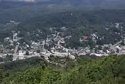 A view overlooking Norton, Virginia at Flag Rock | |
 Seal | |
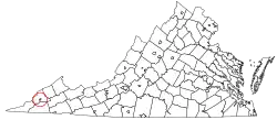 Location in the Commonwealth of Virginia | |
| Coordinates: 36°56′12″N 82°37′30″W | |
| Country | United States |
| State | Virginia |
| County | None (Independent city) |
| Founded | 1894 |
| Named for | Eckstein Norton[1] |
| Government | |
| • Mayor | Joseph Fawbush [2] |
| Area | |
| • Total | 7.51 sq mi (19.46 km2) |
| • Land | 7.48 sq mi (19.37 km2) |
| • Water | 0.03 sq mi (0.09 km2) |
| Elevation | 2,133 ft (650 m) |
| Population (2010) | |
| • Total | 3,958 |
| • Estimate (2019)[4] | 3,981 |
| • Density | 532.43/sq mi (205.57/km2) |
| Time zone | UTC−5 (EST) |
| • Summer (DST) | UTC−4 (EDT) |
| ZIP code | 24273 |
| Area code(s) | 276 |
| FIPS code | 51-57688[5] |
| GNIS feature ID | 1485924[6] |
| Website | http://www.nortonva.org/ |
History
The settlement was originally known as "Prince's Flats," but in a bid to convince the Louisville and Nashville Railroad[8] to build a depot there, the town was renamed after the current head of the railroad, Epstein Norton. Norton was located on the Wilderness Trail, which had been blazed by Daniel Boone, and later extensively mapped and settled by Christopher Gist. the settlement developed as a central hub for the timber trade until the coal boom of the 1830-40s.[9]
The Hotel Norton is listed on the National Register of Historic Places.[10]
The small city has struggled economically, and many of its residents became subjects of abuses in the opioid epidemic. From 2006 to 2012, Norton had the highest rate of prescriptions for opioid pills in the United States. On average, 306 opioid pills per person (every adult and child), per year, were prescribed in Norton.[11]
Education
Norton City Schools is the school division of the city, operating John I. Burton High School and Norton Elementary and Middle School.
Geography
Norton is located at 36°56′12″N 82°37′31″W, along the Powell and Guest Rivers. The entire area of Norton lies within the confines of Wise County, but is not a part of the county.
According to the United States Census Bureau, the city has a total area of 7.5 square miles (19 km2), virtually all of which is land.
Major highways
 US 23
US 23
 US 58 Alt.
Demographics
| Historical population | |||
|---|---|---|---|
| Census | Pop. | %± | |
| 1900 | 654 | — | |
| 1910 | 1,866 | 185.3% | |
| 1920 | 3,068 | 64.4% | |
| 1930 | 3,077 | 0.3% | |
| 1940 | 4,006 | 30.2% | |
| 1950 | 4,315 | 7.7% | |
| 1960 | 4,996 | 15.8% | |
| 1970 | 4,001 | −19.9% | |
| 1980 | 4,757 | 18.9% | |
| 1990 | 4,247 | −10.7% | |
| 2000 | 3,904 | −8.1% | |
| 2010 | 3,958 | 1.4% | |
| 2019 (est.) | 3,981 | [4] | 0.6% |
| U.S. Decennial Census[12] 1790–1960[13] 1900–1990[14] 1990–2000[15] 2010–2018[16] | |||
As of the census[17] of 2000, there were 3,904 people, 1,730 households, and 1,067 families residing in the city. The population density was 518.5 people per square mile (200.2/km2). There were 1,946 housing units at an average density of 258.4 per square mile (99.8/km2). The racial makeup of the city was 91.57% White, 6.15% Black, 0.08% Native American, 1.00% Asian, 0.13% Pacific Islander, 0.18% from other races, and 0.90% from two or more races. Hispanic or Latino of any race were 0.87% of the population.
There were 1,730 households, out of which 26.1% had children under the age of 18 living with them, 43.0% were married couples living together, 15.7% had a female householder with no husband present, and 38.3% were non-families. 34.9% of all households were made up of individuals, and 14.3% had someone living alone who was 65 years of age or older. The average household size was 2.23 and the average family size was 2.88.
In the city, the population was spread out, with 21.8% under the age of 18, 10.2% from 18 to 24, 27.3% from 25 to 44, 25.4% from 45 to 64, and 15.3% who were 65 years of age or older. The median age was 39 years. For every 100 females, there were 81.8 males. For every 100 females age 18 and over, there were 78.5 males.
The median income for a household in the city was $22,788, and the median income for a family was $30,889. Males had a median income of $30,000 versus $23,229 for females. The per capita income for the city was $16,024. About 19.1% of families and 22.8% of the population were below the poverty line, including 35.7% of those under age 18 and 12.1% of those age 65 or over.
Notable people
- Dock Boggs – musician and songwriter
- Vernon Crawford "Jack" Cooke – bluegrass musician
Politics
| Year | Republican | Democratic | Third Parties |
|---|---|---|---|
| 2020 | 69.3% 1,109 | 29.0% 464 | 1.8% 28 |
| 2016 | 69.9% 1,021 | 26.2% 383 | 3.8% 56 |
| 2012 | 60.0% 895 | 37.9% 566 | 2.1% 31 |
| 2008 | 49.2% 744 | 49.1% 743 | 1.7% 25 |
| 2004 | 51.1% 768 | 48.2% 725 | 0.7% 11 |
| 2000 | 41.8% 639 | 56.7% 867 | 1.6% 24 |
| 1996 | 30.1% 416 | 58.0% 802 | 11.9% 164 |
| 1992 | 30.5% 472 | 56.3% 871 | 13.3% 205 |
| 1988 | 42.7% 608 | 55.9% 795 | 1.4% 20 |
| 1984 | 48.3% 806 | 50.5% 842 | 1.2% 20 |
| 1980 | 40.9% 572 | 54.4% 762 | 4.7% 66 |
| 1976 | 40.4% 577 | 56.7% 811 | 2.9% 42 |
| 1972 | 62.7% 823 | 35.3% 463 | 2.1% 27 |
| 1968 | 39.1% 495 | 43.8% 555 | 17.1% 217 |
| 1964 | 31.1% 372 | 68.9% 824 | |
| 1960 | 51.0% 549 | 48.9% 526 | 0.1% 1 |
| 1956 | 55.1% 684 | 44.5% 552 | 0.4% 5 |
References
- "Norton History | Norton, VA". City of Norton. Retrieved 18 November 2020.
- "City Council". City of Norton. Retrieved 9 November 2020.
- "2019 U.S. Gazetteer Files". United States Census Bureau. Retrieved August 7, 2020.
- "Population and Housing Unit Estimates". United States Census Bureau. May 24, 2020. Retrieved May 27, 2020.
- "U.S. Census website". United States Census Bureau. Retrieved 2008-01-31.
- "US Board on Geographic Names". United States Geological Survey. 2007-10-25. Retrieved 2008-01-31.
- "State & County QuickFacts". United States Census Bureau. Archived from the original on January 7, 2014. Retrieved January 6, 2014.
- "Evolution of Norton". City of Norton. City of Norton. Retrieved 5 May 2017.
- Te nnis, Joe (2004). Southwest Virginia Crossroads: An Almanac of Place Names and Places to See. The Overmountain Press. p. 19. ISBN 978-1-57072-256-1.
- "National Register Information System". National Register of Historic Places. National Park Service. July 9, 2010.
- https://www.washingtonpost.com/investigations/76-billion-opioid-pills-newly-released-federal-data-unmasks-the-epidemic/2019/07/16/5f29fd62-a73e-11e9-86dd-d7f0e60391e9_story.html
- "U.S. Decennial Census". United States Census Bureau. Retrieved January 6, 2014.
- "Historical Census Browser". University of Virginia Library. Retrieved January 6, 2014.
- "Population of Counties by Decennial Census: 1900 to 1990". United States Census Bureau. Retrieved January 6, 2014.
- "Census 2000 PHC-T-4. Ranking Tables for Counties: 1990 and 2000" (PDF). United States Census Bureau. Retrieved January 6, 2014.
- "County Population Totals and Components of Change: 2010-2018". Retrieved May 25, 2019.
- "U.S. Census website". United States Census Bureau. Retrieved 2011-05-14.
- David Leip. "Dave Leip's Atlas of U.S. Presidential Elections". Uselectionatlas.org. Retrieved 2020-12-10.
External links
| Authority control |
|---|