U.S. Route 21
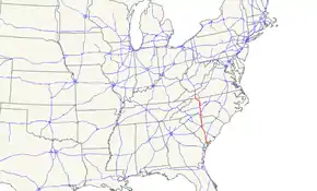
U.S. Route 21 or U.S. Highway 21 (US 21) is a north–south United States Numbered Highway in the Southeastern United States that travels 394 miles (634 km). The southern terminus is in Hunting Island State Park, South Carolina, 14.4 miles (23.2 km) of US 21 Business and South Carolina Highway 802 (SC 802) in Beaufort. The northern terminus is in Wytheville, Virginia at an interchange with Interstate 81 (I-81) and US 52. It travels through the states of South Carolina, North Carolina, and Virginia. It also connects through major Southeastern cities such as Columbia, South Carolina and Charlotte, North Carolina. The northern portion of the road travels parallel to I-77 in northern South Carolina and North Carolina. The road also has three interchanges with I-26 in Lexington and Calhoun counties in South Carolina.
| ||||||||||||
|---|---|---|---|---|---|---|---|---|---|---|---|---|
 | ||||||||||||
| Route information | ||||||||||||
| Length | 394 mi (634 km) | |||||||||||
| Existed | 1926–present | |||||||||||
| Tourist routes |
| |||||||||||
| Major junctions | ||||||||||||
| South end | Hunting Island State Park, SC | |||||||||||
| ||||||||||||
| North end | ||||||||||||
| Location | ||||||||||||
| States | South Carolina, North Carolina, Virginia | |||||||||||
| Counties | SC: Beaufort, Hampton, Colleton, Bamberg, Orangeburg, Calhoun, Lexington, Richland, Fairfield, Chester, York NC: Mecklenburg, Iredell, Yadkin, Surry, Wilkes, Alleghany VA: Grayson, Wythe | |||||||||||
| Highway system | ||||||||||||
| ||||||||||||

Route description
South Carolina
US 21 travels 233.2 miles (375.3 km) through the state. Beginning at Hunting Island State Park, US 21 travels west toward Beaufort, where it widens to four lanes. The route bypasses Beaufort to the south, going through Port Royal, Shell Point, and Burton. In the Beaufort area, US 21 passes by the entrances to Parris Island and MCAS Beaufort, the major Marine Corps installations in the area. North of Beaufort, US 21 continues as a four-lane divided highway and intersects with US 17. The route travels in a wrong-way concurrency with US 17 south for seven miles (11 km) before turning north towards Yemassee, South Carolina, where it becomes a rural two-lane road and intersects with US 17 Alternate. North of Yemassee, US 21 splits off and crosses Interstate 95 (I-95) at exit 42.
The two-lane route continues through rural portions of the state. US 21 goes through Smoaks and Branchville, South Carolina and bypasses Orangeburg. North of Orangeburg, US 21 runs roughly parallel to I-26 until Gaston where it conjoins US 321 and becomes an urban highway. US 21 passes through Cayce, West Columbia, and Columbia.
North of Columbia, US 21 splits from US 321, reverting to a rural two-lane road parallel to I-77. In York County, US 21 enters urban areas again, connecting Rock Hill and Fort Mill. Near the North Carolina state line, US 21 merges with I-77 near Carowinds, then enters North Carolina.
North Carolina
US 21 begins as a concurrency with I-77 in Charlotte, which it repeats three times within the state. Its first break with I-77 is along Statesville Avenue, then proceeding through Huntersville and Cornelius, however, because of its close proximity to I-77 and North Carolina Highway 115 (NC 115), it has no interchange with I-485. The second break with I-77 occurs at Mooresville, where US 21 travels through the city and then northwest into Statesville. After Statesville, US 21 travels northeast to Harmony and Brooks Crossroads, before merging back with I-77 near Jonesville. North of Elkin, US 21 splits with I-77 for the last time and goes north to Sparta, passing the Blue Ridge Parkway after a major, curvy section. North of Sparta, at Twin Oaks, US 221 overlaps with US 21 before entering Virginia. US 21 travels 124.5 miles (200.4 km) through the western Piedmont of North Carolina, either combined with I-77 or as a two-lane rural road; from the South Carolina state line to Elkin, travelers can easily skip a majority of US 21 via I-77.
Virginia
_at_Spring_Valley_Road_(Virginia_State_Secondary_Route_805)_in_northern_Grayson_County%252C_Virginia.jpg.webp)
After a few miles crossing the state line, US 21 reaches the town of Independence, where it splits with US 221 and continues north. The route goes through the Mount Rogers National Recreation Area before entering the city of Wytheville. After a short concurrency with US 11 in downtown Wytheville, it goes north and ends at the intersection of I-81/US 52. US 21 travels 35 miles (56 km) through western Virginia, mostly as a two-lane rural mountain road.
History
US 21 in the pre-Interstate era was a north–south highway connecting the area around Lake Erie and the coastal South. One of the few true north–south routes to cross the middle Appalachian Mountains, it became an important corridor for motor traffic between northeastern Ohio, western Pennsylvania, (with US 19) and western New York state with central North Carolina, central and southeastern South Carolina, and (by connecting with other highways) coastal Georgia and most of Florida.
US 21 originally (in 1926) connected Cleveland, Ohio, and Yemassee, South Carolina. In 1935 it was extended to Beaufort, South Carolina, and again in 1953 to its current southern terminus at the Atlantic Coast at Hunting Island State Park, between the city of Beaufort and Fripp Island.[1]
In the Interstate Highway era much of US 21 became an obvious corridor for a long-distance expressway. The West Virginia Turnpike between Charleston, West Virginia, and Princeton, West Virginia, was the first segment of a planned series of toll highways along or near US 21 from Cleveland to Charlotte, North Carolina. All of the other toll highways were shelved in favor of freeways built with Interstate funding; these freeways and the West Virginia Turnpike became I-77, which completely supplanted old US 21 as a long-distance through route. I-77 was later extended to Columbia, South Carolina, also within a few miles of US 21.
Between Cleveland and Charleston, all but a relatively short segment of US 21 was completely deleted in favor of I-77, the relics being State Route 21 (SR 21), SR 821 between Byesville and Marietta, Ohio, and Guernsey County Road 35 and Tuscarawas County Road 3 (Salt Fork Road), named Old Twenty-One Road and closely follows the route of US 21 from Byesville, Ohio to the village of Newcomerstown, Ohio. County Road 35 briefly becomes a variety of street names as it passes through Cambridge, such as Byesville Road, North Avenue, 11th Street, and Clark Street, before reverting to Old Twenty-One Road on the north side of Cambridge. From there, much of the old US 21 is still intact, however, some sections were demolished and redirected in favor of I-77. Once crossing the Guernsey/Tuscarawas county line, it becomes Salt Fork Road for about a mile, before joining Ohio State Route 258, which takes it the rest of the way to Newcomerstown. In total, the entire section of Old Twenty-One Road between North Cambridge and Newcomerstown is a total of 22.5 miles. The section of US 21 between Mineral Wells and Charleston is now signed as County Route 21 in all four counties along the route (Wood, Wirt, Jackson, and Kanawha).
Between Charleston and its current northern terminus at Wytheville, Virginia, almost all of US 21 coincided with either US 60, US 19, or US 52, which remained as US 21 was deleted. The short segment of US 21 in southern West Virginia not coinciding with another U.S. Highway became an extension of West Virginia Route 16.
In North Carolina, US 21 originally entered the state along today's NC 51 into Pineville, then followed Old Pineville Road into Charlotte. In the mid-1930s, US 21 moved over to South Boulevard from Old Pineville Road. In 1969, US 21 was rerouted following today's I-77 alignment, the old route was replaced by an extension of US 521. From 1975–87, US 21 moved north in segments onto I-77 to its current alignment ending at exit 16A (Sunset Road). Further north, US 21 originally followed Old Statesville Road, replaced in 1956 by NC 115. In 1966, US 21 was bypassed around Jonesville and Elkin, replaced with US 21 Business.[2]
Major intersections
| State | County | Location | mi[3][4][5] | km | Exit | Destinations | Notes |
|---|---|---|---|---|---|---|---|
| South Carolina | Beaufort | | 0.0 | 0.0 | Hunting Island State Park | Southern terminus; US 21 begins at intersection of walking trail, road continues south to Fripp Island. | |
| Beaufort | 14.4 | 23.2 | Southern terminus of US 21 Bus.; western terminus of SC 802; US 21 turns left. | ||||
| 17.3 | 27.8 | Southern terminus of SC 281; eastern terminus of Waddell Road; US 21 turns left off of Ladys Island Drive (which ends here) and onto Ribaut Road. | |||||
| Port Royal | 21.0 | 33.8 | Eastern terminus of SC 128 | ||||
| Beaufort | 24.1 | 38.8 | |||||
| Burton | 25.3 | 40.7 | Northern terminus of US 21 Bus.; US 21 turns left. | ||||
| Burton–Beaufort line | 26.7 | 43.0 | Eastern terminus of SC 116 | ||||
| Gardens Corner | 37.3 | 60.0 | Southern end of US 17 concurrency | ||||
| Pocotaligo | 43.9 | 70.7 | Northern end of US 17 concurrency; southern end of US 17 Alt. concurrency; southern terminus of US 17 Alt.; US 21 turns right. | ||||
| Hampton | Yemassee | 3.8 | 6.1 | Eastern terminus of SC 68; northern terminus of US 17 Conn. | |||
| Colleton | | 51.3 | 82.6 | Northern end of US 17 Alt. concurrency | |||
| | 54.0 | 86.9 | I-95 exit 42 | ||||
| | 63.9 | 102.8 | |||||
| | 70.3 | 113.1 | |||||
| Smoaks | 79.0 | 127.1 | |||||
| Bamberg | | 85.0 | 136.8 | ||||
| Orangeburg | Branchville | 90.7 | 146.0 | Southern end of US 78 concurrency | |||
| 90.9 | 146.3 | Northern end of US 78 concurrency | |||||
| 91.3 | 146.9 | Southern terminus of SC 210 | |||||
| Orangeburg | 106.3 | 171.1 | Southern end of US 601 Truck concurrency; southern terminus of US 21 Bus.; eastern terminus of SC 4; US 21 turns right. | ||||
| 106.4 | 171.2 | Southern end of US 178 concurrency; eastern terminus of US 178 Bus. | |||||
| 107.7 | 173.3 | ||||||
| 108.8 | 175.1 | ||||||
| 109.6 | 176.4 | Northern end of US 601 Truck concurrency; northern terminus of US 601 Truck | |||||
| 110.8 | 178.3 | Northern end of US 178 concurrency; northern terminus of US 21 Conn.; US 21 turns right off of Chestnut Street and onto Columbia Road. | |||||
| Calhoun | | 122.5 | 197.1 | Southern end of SC 6 concurrency (southbound only) | |||
| | Southern end of SC 6 concurrency (northbound only) | ||||||
| | 124.4 | 200.2 | Northern end of SC 6 concurrency | ||||
| Lexington | | 129.5 | 208.4 | I-26 exit 129 | |||
| Calhoun | | 132.2 | 212.8 | Southern end of US 176 concurrency | |||
| Lexington | | 139.3 | 224.2 | I-26 exit 119 | |||
| | 141.0 | 226.9 | Southern end of US 321 concurrency | ||||
| Cayce | 143.5 | 230.9 | I-77 exit 1 | ||||
| 143.9 | 231.6 | I-26 exit 115 | |||||
| 145.1 | 233.5 | Southern terminus of SC 2 | |||||
| West Columbia | 146.6 | 235.9 | Northern terminus of SC 302 | ||||
| 148.3 | 238.7 | ||||||
| Richland | Columbia | Western terminus of US 21 Conn., US 76 Conn., and SC 48 Truck; US 21, US 176, and US 321 turn left off of Blossom Street and onto Huger Street. | |||||
| 149.8 | 241.1 | ||||||
| 150.2 | 241.7 | Eastbound lanes of SC 12 on one-way road | |||||
| Westbound lanes of SC 12 on one-way road | |||||||
| 150.7 | 242.5 | Southern end of US 76 concurrency; eastern terminus of I-126; Rep. T. Moffatt Burriss Sr. Interchange; US 21, US 176, and US 321 curve right off of Huger Street and onto Elmwood Avenue. | |||||
| Western terminus of SC 48 | |||||||
| 151.7 | 244.1 | Northern end of US 76 concurrency; US 21, US 176, and US 321 turn left off of Elmwood Avenue and onto Main Street. | |||||
| 151.9 | 244.5 | Northern end of US 176 concurrency | |||||
| 152.6 | 245.6 | ||||||
| 153.1 | 246.4 | Southern terminus of SC 215 | |||||
| 154.1 | 248.0 | Northern end of US 321 concurrency | |||||
| 156.6 | 252.0 | I-20 exit 71 | |||||
| Blythewood | 164.1 | 264.1 | I-77 exit 24 | ||||
| 165.3 | 266.0 | ||||||
| Fairfield | | Coleman Highway west (US 21 Conn. north) – Winnsboro | Southern terminus of US 21 Conn.; eastern terminus of Coleman Highway | ||||
| Ridgeway | 173.8 | 279.7 | Southern end of SC 34 concurrency | ||||
| 174.1 | 280.2 | Northern end of SC 34 concurrency | |||||
| | 190.7 | 306.9 | Southern end of SC 200 concurrency | ||||
| Chester | Great Falls | 193.7 | 311.7 | Southern terminus of SC 99 | |||
| 194.8 | 313.5 | Southern end of SC 97 concurrency | |||||
| 195.0 | 313.8 | Northern end of SC 97 and SC 200 concurrencies | |||||
| Fort Lawn | 202.6 | 326.1 | |||||
| | 207.9 | 334.6 | |||||
| York | Lesslie | 215.2 | 346.3 | Southern end of SC 5 concurrency; to Andrew Jackson State Park | |||
| Rock Hill | 218.9 | 352.3 | Springfield Road – Lesslie | Interchange | |||
| 219.7 | 353.6 | I-77 exit 77 | |||||
| 220.2 | 354.4 | Northern end of SC 5 concurrency | |||||
| 220.5 | 354.9 | Southern end of SC 121 concurrency | |||||
| 221.7 | 356.8 | ||||||
| 224.0 | 360.5 | Northern end of SC 121 concurrency; northern terminus of SC 121; eastern terminus of SC 322 | |||||
| 224.5 | 361.3 | Eastern terminus of SC 161; I-77 exit 82 | |||||
| Fort Mill | 226.0 | 363.7 | Southern terminus of US 21 Bus. | ||||
| 228.0 | 366.9 | ||||||
| 230.8 | 371.4 | ||||||
| 232.0 | 373.4 | Northern terminus of US 21 Bus. | |||||
| 232.7 | 374.5 | Southern terminus of northern segment of SC 51 | |||||
| 233.3 | 375.5 | Southern end of I-77 concurrency; I-77 exit 90; to Carowinds | |||||
| 234.1 0.0 | 376.7 0.0 | South Carolina–North Carolina state line | |||||
| North Carolina | Mecklenburg | Charlotte | 0.9 | 1.4 | 1A | Westinghouse Boulevard | |
| 1.8 | 2.9 | 1B | I-485 exit 67 | ||||
| 2.8 | 4.5 | 3 | Arrowood Road | ||||
| 3.7 | 6.0 | 4 | Nations Ford Road | ||||
| 4.8 | 7.7 | 5 | Tyvola Road | ||||
| 6.0 | 9.7 | 6A | Woodlawn Road south – Queens University | To Pfeiffer University | |||
| 6.2 | 10.0 | 6B | To Billy Graham Library and Charlotte Douglas International Airport | ||||
| 7.3 | 11.7 | 7 | |||||
| 8.3 | 13.4 | 8 | Northbound exit and southbound entrance | ||||
| 9.0 | 14.5 | 9A | Southbound exit and northbound entrance | ||||
| 9.4 | 15.1 | 9B | I-277 exits 1B-C | ||||
| 9.5 | 15.3 | 9C | |||||
| 9.9 | 15.9 | 10A | Northbound exit is via exit 9C. | ||||
| 10.4 | 16.7 | 10 | Trade Street / Fifth Street | Signed as exits 10B (Trade Street east) and 10C (Trade Street west, Fifth Street) southbound | |||
| 11.0 | 17.7 | 11A | |||||
| 11.2 | 18.0 | 11B | Northbound left exit | ||||
| 12.4 | 20.0 | 12 | Lasalle Street / Atando Avenue | ||||
| 13.3 | 21.4 | 13 | Signed as exits 13A (north) and 13B (south); hybrid interchange | ||||
| 15.8 | 25.4 | 16 | Northern end of I-77 concurrency | ||||
| 16.3 | 26.2 | Southern terminus of NC 115 | |||||
| 18.9 | 30.4 | To Northlake Mall | |||||
| Huntersville | 25.7 | 41.4 | |||||
| Cornelius | 28.8 | 46.3 | 28 | Southern end of I-77 concurrency | |||
| Davidson | 30.2 | 48.6 | 30 | Davidson, Davidson College | |||
| Iredell | Mooresville | 32.1 | 51.7 | 31 | Langtree Road | ||
| 33.7 | 54.2 | 33 | Northern end of I-77 concurrency | ||||
| 36.4 | 58.6 | ||||||
| 39.1 | 62.9 | Southern end of NC 115 concurrency | |||||
| | 43.3 | 69.7 | |||||
| Statesville | 51.2 | 82.4 | |||||
| 51.9 | 83.5 | Northern end of NC 115 concurrency; southern end of US 64 concurrency | |||||
| 52.3 | 84.2 | Eastern terminus of NC 90 | |||||
| 53.2 | 85.6 | Northern end of US 64 concurrency | |||||
| 54.1 | 87.1 | I-40 exit 151 | |||||
| | 57.2 | 92.1 | I-77 exit 54 | ||||
| Harmony | 66.9 | 107.7 | |||||
| Yadkin | Brooks Crossroads | 79.2 | 127.5 | ||||
| | 85.4 | 137.4 | 79 | Southern end of I-77 concurrency; southern terminus of US 21 Bus. | |||
| Jonesville | 88.5 | 142.4 | 82 | ||||
| Surry | Elkin | 90.3 | 145.3 | 83 | Northern end of I-77 concurrency; southbound exit and northbound entrance | ||
| 91.3 | 146.9 | To Elkin Municipal Airport | |||||
| 92.8 | 149.3 | Northbound turn left on Popular Springs Road to US 21 Bus. | |||||
| Alleghany | | 111.2 | 179.0 | ||||
| Sparta | 118.2 | 190.2 | |||||
| Twin Oaks | 121.1 | 194.9 | Southern end of US 221 concurrency | ||||
| 124.3 0.0 | 200.0 0.0 | North Carolina–Virginia state line | |||||
| Virginia | Grayson | Independence | 3.9 | 6.3 | Northern end of US 221 concurrency | ||
| Elk Creek | 13.2 | 21.2 | |||||
| | |||||||
| Wythe | Speedwell | 21.2 | 34.1 | ||||
| | |||||||
| | |||||||
| Wytheville | Old Stage Road | ||||||
| 33.5 | 53.9 | Southern end of US 11 concurrency | |||||
| 33.8 | 54.4 | Northern end of US 11 concurrency | |||||
| 35.0 | 56.3 | Northern terminus; I-81 exit 70 | |||||
1.000 mi = 1.609 km; 1.000 km = 0.621 mi
| |||||||
Special routes and auxiliary routes
There are currently four active business loops and two known connectors along its route.
- U.S. Route 21 Business (Beaufort, South Carolina)
- U.S. Route 21 Business (Orangeburg, South Carolina)
- U.S. Route 21 Connector (Orangeburg, South Carolina)
- U.S. Route 21 Connector (Columbia, South Carolina)
- U.S. Route 21 Business (Fort Mill, South Carolina)
- U.S. Route 21 Business (Elkin, North Carolina)
Auxiliary routes of U.S. Route 21
See also
References
- Sanderson, Dale (July 4, 2009). "End of US Highway 21". US Ends. Self-published. Retrieved February 2, 2011.
- Mapmikey; Prince, Adam (August 28, 2009). "US 21". NCRoads.com Annex: More Highways of North Carolina. Self-published. Archived from the original on June 16, 2011. Retrieved February 2, 2011.
- Google (February 1, 2011). "Overview map of US 21 in SC" (Map). Google Maps. Google. Retrieved February 1, 2011.
- Google (February 1, 2011). "Overview map of US 21 in NC" (Map). Google Maps. Google. Retrieved February 1, 2011.
- Google (February 1, 2011). "Overview maps of US 21 in VA" (Map). Google Maps. Google. Retrieved February 1, 2011.
External links
 Media related to U.S. Route 21 at Wikimedia Commons
- Endpoints of U.S. Highway 21
Routes in italics are no longer a part of the system. Highlighted routes are considered main routes of the system. |