Upshur County, West Virginia
Upshur County is a county in the U.S. state of West Virginia. As of the 2010 census, the population was 24,254.[2] Its county seat is Buckhannon.[3] The county was formed in 1851 from Randolph, Barbour, and Lewis counties and named for Abel Parker Upshur, a distinguished statesman and jurist of Virginia.[4] Upshur served as United States Secretary of State and Secretary of the Navy under President John Tyler.
Upshur County | |
|---|---|
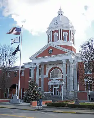 The Upshur County Courthouse, designed by architect Harrison Albright[1] pictured in Buckhannon in 2006 | |
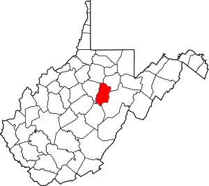 Location within the U.S. state of West Virginia | |
 West Virginia's location within the U.S. | |
| Coordinates: 38°54′N 80°14′W | |
| Country | |
| State | |
| Founded | March 26, 1851 |
| Named for | Abel Parker Upshur |
| Seat | Buckhannon |
| Largest city | Buckhannon |
| Area | |
| • Total | 355 sq mi (920 km2) |
| • Land | 355 sq mi (920 km2) |
| • Water | 0.1 sq mi (0.3 km2) 0.03%% |
| Population (2010) | |
| • Total | 24,254 |
| • Estimate (2019) | 24,176 |
| • Density | 68/sq mi (26/km2) |
| Time zone | UTC−5 (Eastern) |
| • Summer (DST) | UTC−4 (EDT) |
| Congressional district | 2nd |
| Website | www |
Geography
According to the U.S. Census Bureau, the county has a total area of 355 square miles (920 km2), of which 354.9 square miles (919 km2) is land and 0.1 square mile (0.26 km2) (0.03%) is water.[5] The county falls within the United States National Radio Quiet Zone. The highest elevation in Upshur County is 3,160 feet, near Sugar Run on the Randolph and Upshur County lines just outside Palace Valley and Hemlock. It is reported there as an elevation marker at the site.
In 1863, West Virginia's counties were divided into civil townships, with the intention of encouraging local government. This proved impractical in the heavily rural state, and in 1872 the townships were converted into magisterial districts.[6] Upshur County was divided into six districts: Banks, Buckhannon, Meade, Union, Warren, and Washington. In the 1990s, the six historic magisterial districts were consolidated into three new districts: First, Second, and Third.[7]
Major highways
 U.S. Highway 33
 U.S. Highway 48
 U.S. Highway 119
 West Virginia Route 4
 West Virginia Route 20
Adjacent counties
- Harrison County (north)
- Barbour County (northeast)
- Randolph County (southeast)
- Webster County (south)
- Lewis County (west)
Demographics
| Historical population | |||
|---|---|---|---|
| Census | Pop. | %± | |
| 1860 | 7,292 | — | |
| 1870 | 8,023 | 10.0% | |
| 1880 | 10,249 | 27.7% | |
| 1890 | 12,714 | 24.1% | |
| 1900 | 14,696 | 15.6% | |
| 1910 | 16,629 | 13.2% | |
| 1920 | 17,851 | 7.3% | |
| 1930 | 17,944 | 0.5% | |
| 1940 | 18,360 | 2.3% | |
| 1950 | 19,242 | 4.8% | |
| 1960 | 18,292 | −4.9% | |
| 1970 | 19,092 | 4.4% | |
| 1980 | 23,427 | 22.7% | |
| 1990 | 22,867 | −2.4% | |
| 2000 | 23,404 | 2.3% | |
| 2010 | 24,254 | 3.6% | |
| 2019 (est.) | 24,176 | [8] | −0.3% |
| U.S. Decennial Census[9] 1790–1960[10] 1900–1990[11] 1990–2000[12] 2010–2019[2] | |||
2000 census
As of the census of 2000[13] there were 24,254 people, 9,619 households, and 6,528 families living in the county. The population density was 68.4 people per square mile (25/km2). There were 11,099 housing units at an average density of 31.3 per square mile (12/km2). The racial makeup of the county was 97.6% White, 0.7% Black or African American, 0.2% Native American, 0.2% Asian, 0.2% from other races, and 1% from two or more races. 1% of the population were Hispanic or Latino of any race.
There were 9,619 households, out of which 28.7% had children under the age of 18 living with them, 54% were married couples living together, 9.6% had a female householder with no husband present, and 32.1% were non-families. 26.9% of all households were made up of individuals, and 12.2% had someone living alone who was 65 years of age or older. The average household size was 2.4 and the average family size was 2.88.
In the county, the population was spread out, with 24.7% from age 0 to 19, 7.60% from 20 to 24, 22.6% from 25 to 44, 28.3% from 45 to 64, and 16.6% who were 65 years of age or older. The median age was 41 years. For every 100 females there were 97 males.
The median income for a household in the county was $39,381, whereas the median income for families was 44,937 . Males had a median income of $36,517 versus $25,420 for females. The per capita income for the county was $19,498. About 14.1% of families and 19.3% of the population were below the poverty line, including 26.7% of those under age 18 and 14.1% of those age 65 or over.
2010 census
As of the 2010 United States Census, there were 24,254 people, 9,619 households, and 6,528 families living in the county.[14] The population density was 68.4 inhabitants per square mile (26.4/km2). There were 11,099 housing units at an average density of 31.3 per square mile (12.1/km2).[15] The racial makeup of the county was 97.6% white, 0.7% black or African American, 0.4% Asian, 0.2% American Indian, 0.2% from other races, and 1.0% from two or more races. Those of Hispanic or Latino origin made up 1.0% of the population.[14] In terms of ancestry, 18.1% were German, 13.8% were American, 10.6% were Irish, and 8.6% were English.[16]
Of the 9,619 households, 28.7% had children under the age of 18 living with them, 54.0% were married couples living together, 9.6% had a female householder with no husband present, 32.1% were non-families, and 26.9% of all households were made up of individuals. The average household size was 2.40 and the average family size was 2.88. The median age was 40.9 years.[14]
The median income for a household in the county was $36,114 and the median income for a family was $44,937. Males had a median income of $36,517 versus $25,420 for females. The per capita income for the county was $18,823. About 14.1% of families and 19.3% of the population were below the poverty line, including 26.7% of those under age 18 and 14.1% of those age 65 or over.[17]
Communities
City
- Buckhannon (county seat)
Current
- First
- Second
- Third
Historic
Upshur County was divided into six townships on July 31, 1863. They were replaced in the 1990s.
- Banks District, named for Nathaniel Prentiss Banks
- Buckhannon District, named for the county seat, the City of Buckhannon
- Meade District, named for General George Gordon Meade
- Union District, named for military soldiers serving the Union cause
- Warren District, named for Gouverneur Kemble Warren
- Washington District, named for President George Washington
Unincorporated communities
- Abbott
- Adrian
- Alexander
- Alton
- Arlington
- Atlas
- Beans Mill
- Canaan
- Carter
- Craddock
- Daysville
- Deanville
- Eden
- Ellamore
- Evergreen
- Excelsior
- Five Forks
- Freeman
- French Creek
- Frenchton
- Gaines
- Gale
- Goodwin
- Gormley
- Goshen
- Gould
- Hampton
- Heavener Grove
- Hemlock
- Hinkleville
- Hodgesville
- Holly Grove
- Hoover Town
- Imperial
- Ingo
- Ivy
- Kanawha Head
- Kedron
- Kesling Mill
- Lorentz
- McCuetown
- Midvale
- Nebo
- Newlonton
- Overhill
- Palace Valley
- Post Mill
- Queens
- Red Rock
- Reger
- Rock Cave
- Rocky Ford
- Ruraldale
- Sago
- Sand Run
- Selbyville
- Shahan
- South Buckhannon
- Swamp Run
- Tallmansville
- Tenmile
- Tennerton
- Teter
- Vegan
- White Oak
- Wilsontown
- Yokum
- Zion
Politics
Whereas most of West Virginia has seen a rapid and continuing shift to the Republican Party since the 1990s as a result of Democratic environmental and immigration politics, Upshur County—though strongly Democratic during the Second Party System—has ever since statehood been a Republican stronghold due to its powerful Unionist sympathies from Civil War days, and the association of the Democratic Party with the “Slave Power” and creating a war the yeoman residents had no desire to fight.[18] The solitary post-Civil War Democrat to win the county has been Lyndon Johnson in 1964, and he won by only 168 votes. Since 1896, only two other Democrats—Jimmy Carter in 1976 and Bill Clinton in 1996—have topped forty percent in the county.
| Year | Republican | Democratic | Third parties |
|---|---|---|---|
| 2020 | 76.0% 7,771 | 22.1% 2,256 | 1.9% 184 |
| 2016 | 75.3% 7,005 | 19.0% 1,766 | 5.7% 527 |
| 2012 | 71.6% 5,939 | 26.0% 2,158 | 2.4% 201 |
| 2008 | 65.9% 5,911 | 32.6% 2,925 | 1.5% 135 |
| 2004 | 66.6% 6,191 | 32.7% 3,034 | 0.7% 68 |
| 2000 | 63.6% 5,165 | 34.1% 2,770 | 2.3% 188 |
| 1996 | 44.7% 3,325 | 41.0% 3,052 | 14.4% 1,070 |
| 1992 | 42.5% 3,505 | 38.3% 3,161 | 19.2% 1,587 |
| 1988 | 61.0% 4,813 | 38.8% 3,065 | 0.2% 16 |
| 1984 | 70.3% 5,951 | 29.2% 2,468 | 0.6% 47 |
| 1980 | 58.7% 4,751 | 35.4% 2,867 | 5.9% 481 |
| 1976 | 57.7% 4,789 | 42.3% 3,513 | |
| 1972 | 78.2% 6,449 | 21.8% 1,795 | |
| 1968 | 62.4% 4,565 | 31.7% 2,319 | 5.8% 427 |
| 1964 | 48.9% 3,606 | 51.1% 3,774 | |
| 1960 | 66.4% 5,123 | 33.6% 2,590 | |
| 1956 | 73.3% 5,707 | 26.7% 2,081 | |
| 1952 | 72.7% 5,938 | 27.3% 2,234 | |
| 1948 | 68.3% 5,068 | 31.3% 2,323 | 0.4% 28 |
| 1944 | 72.5% 5,332 | 27.5% 2,026 | |
| 1940 | 68.0% 6,086 | 32.0% 2,862 | |
| 1936 | 64.3% 5,745 | 35.4% 3,163 | 0.3% 26 |
| 1932 | 61.2% 5,077 | 38.0% 3,147 | 0.8% 68 |
| 1928 | 75.2% 5,277 | 24.0% 1,683 | 0.8% 57 |
| 1924 | 70.2% 4,930 | 27.8% 1,952 | 2.0% 137 |
| 1920 | 77.2% 4,936 | 22.2% 1,418 | 0.7% 42 |
| 1916 | 70.1% 2,553 | 28.0% 1,019 | 1.9% 68 |
| 1912 | 23.9% 835 | 25.6% 895 | 50.5% 1,767 |
Economy
Economy includes coal mining and timber, as well as higher education—the Upshur County seat of Buckhannon is home to the small, private, liberal arts institution West Virginia Wesleyan College. The West Virginia State Wildlife Center in French Creek also generates some income as a popular tourist attraction. Upshur County also gained international attention during the Sago Mine disaster in 2006; the blast and ensuing aftermath trapped 13 coal mining for nearly two days, only one of whom survived.
See also
References
- Cutright, W (2009). The History of Upshur County, West Virginia. Clearfield. p. 280. ISBN 0806346353.
- "State & County QuickFacts". United States Census Bureau. Retrieved January 16, 2014.
- "Find a County". National Association of Counties. Retrieved June 7, 2011.
- "Archived copy". Archived from the original on September 23, 2001. Retrieved February 4, 2013.CS1 maint: archived copy as title (link)
- "2010 Census Gazetteer Files". United States Census Bureau. August 22, 2012. Retrieved July 31, 2015.
- Otis K. Rice & Stephen W. Brown, West Virginia: A History, 2nd ed., University Press of Kentucky, Lexington (1993), p. 240.
- United States Census Bureau, U.S. Decennial Census, Tables of Minor Civil Divisions in West Virginia, 1870–2010.
- "Population and Housing Unit Estimates". Retrieved March 29, 2020.
- "U.S. Decennial Census". United States Census Bureau. Retrieved January 16, 2014.
- "Historical Census Browser". University of Virginia Library. Retrieved January 16, 2014.
- "Population of Counties by Decennial Census: 1900 to 1990". United States Census Bureau. Retrieved January 16, 2014.
- "Census 2000 PHC-T-4. Ranking Tables for Counties: 1990 and 2000" (PDF). United States Census Bureau. Retrieved January 16, 2014.
- "U.S. Census website". United States Census Bureau. Retrieved May 14, 2011.
- "DP-1 Profile of General Population and Housing Characteristics: 2010 Demographic Profile Data". United States Census Bureau. Archived from the original on February 13, 2020. Retrieved April 3, 2016.
- "Population, Housing Units, Area, and Density: 2010 - County". United States Census Bureau. Archived from the original on February 13, 2020. Retrieved April 3, 2016.
- "DP02 SELECTED SOCIAL CHARACTERISTICS IN THE UNITED STATES – 2006-2010 American Community Survey 5-Year Estimates". United States Census Bureau. Archived from the original on February 13, 2020. Retrieved April 3, 2016.
- "DP03 SELECTED ECONOMIC CHARACTERISTICS – 2006-2010 American Community Survey 5-Year Estimates". United States Census Bureau. Archived from the original on February 13, 2020. Retrieved April 3, 2016.
- Denton, Lawrence M.; Unionists in Virginia: Politics, Secession and Their Plan to Prevent Civil War, ISBN 1625852797
- Leip, David. "Dave Leip's Atlas of U.S. Presidential Elections". uselectionatlas.org. Retrieved March 28, 2018.
External links
- Buckhannon-Upshur Chamber of Commerce
- Upshur County Board of Education
- Upshur County Development Authority
- Upshur County Public Library
- Upshur County Historical Society
- The Record Delta newspaper
- West Virginia Strawberry Festival
- Upshur County WVGenWeb
Places adjacent to Upshur County, West Virginia | ||||||||||
|---|---|---|---|---|---|---|---|---|---|---|
| ||||||||||
Municipalities and communities of Upshur County, West Virginia, United States | ||
|---|---|---|
| City | Map of West Virginia highlighting Upshur County | |
| Unincorporated communities |
| |
| Ghost town | ||
| Footnotes | ‡This populated place also has portions in an adjacent county or counties | |
| ||
| Authority control |
|---|