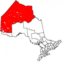
Unorganized Kenora District
Unorganized Kenora District is an unorganized area in northwestern Ontario, Canada, in Kenora District. Comprising 98.39 percent of the district's land area, yet only 10.93 percent of its population, it is essentially the remainder of the district's territory after all incorporated cities, municipalities, townships, Indian reserves, and Indian settlements have been excluded. It is by far the largest municipal-equivalent level census division in Ontario, covering over 35 percent of the entire provincial land area, yet only about 0.05 percent of the population of Ontario.
Unorganized Kenora District | |
|---|---|
| Kenora, Unorganized | |
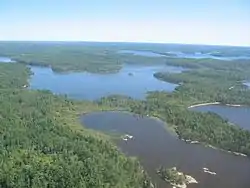 Scenery near Minaki | |
 | |
| Coordinates: 53°00′N 89°00′W | |
| Country | |
| Province | |
| District | Kenora |
| Government | |
| • Federal riding | Kenora, Timmins—James Bay |
| • Prov. riding | Kenora—Rainy River, Timmins—James Bay |
| Area | |
| • Land | 400,771.81 km2 (154,738.86 sq mi) |
| Population (2011)[1] | |
| • Total | 7,031 |
| • Density | 0.02/km2 (0.05/sq mi) |
| Time zones | UTC-5 (EST) |
| • Summer (DST) | UTC-4 (EDT) |
| UTC-6 (CST) | |
| • Summer (DST) | UTC-5 (CDT) |
| Postal Code FSA | P |
| Area code(s) | 705, 807 |
Local services boards
Demographics
| Canada census – Kenora, Unorganized community profile | |||
|---|---|---|---|
| 2011 | 2006 | ||
| Population: | 7031 (-0.1% from 2006) | 7041 (-7.7% from 2001) | |
| Land area: | 400,771.81 km2 (154,738.86 sq mi) | 400,652.34 km2 (154,692.73 sq mi) | |
| Population density: | 0.0/km2 (0/sq mi) | 0.0/km2 (0/sq mi) | |
| Median age: | 44.3 (M: 44.9, F: 43.8) | ||
| Total private dwellings: | 7394 | 7603 | |
| Median household income: | $43,499 | ||
| References: 2011[2] 2006[3] earlier[4] | |||
Population trend:[5]
- Population in 2011: 7,031
- Population in 2006: 7,041
- Population in 2001: 7,631
- Population in 1996: 10,269 (or 7,981 when adjusted to 2001 boundaries)
- Population in 1991: 9,723
References
- "Kenora, Unorganized census profile". 2011 Census of Population. Statistics Canada. Retrieved 2012-02-10.
- "2011 Community Profiles". 2011 Canadian Census. Statistics Canada. July 5, 2013. Retrieved 2012-02-10.
- "2006 Community Profiles". 2006 Canadian Census. Statistics Canada. March 30, 2011. Retrieved 2011-06-28.
- "2001 Community Profiles". 2001 Canadian Census. Statistics Canada. February 17, 2012.
- Statistics Canada: 1996, 2001, 2006 census
| Cities | 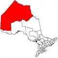 | |
|---|---|---|
| Towns | ||
| Townships | ||
| First Nations |
| |
| Indian reserves |
| |
| Indian settlements | ||
| Unorganized areas | ||
| Local services boards |
| |
| Unincorporated communities | ||
| ||
This article is issued from Wikipedia. The text is licensed under Creative Commons - Attribution - Sharealike. Additional terms may apply for the media files.