Whetstone, London
Whetstone /ˈwɛtstoʊn/ is a place in the London Borough of Barnet, bearing the postcode N20. It is to the east of Totteridge, and these areas are known together as Totteridge and Whetstone. Whetstone is around 8.5 miles North of Charing Cross. The combined areas of Totteridge and Whetstone was, at the outset of the 21st century, found to be the 63rd-richest of the more than 9,000 wards of the United Kingdom.[1]
| Whetstone | |
|---|---|
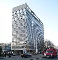 Barnet council offices dominate the centre of Whetstone. | |
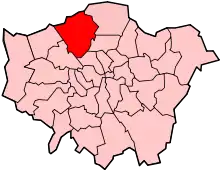
 Whetstone Location within Greater London | |
| OS grid reference | TQ265935 |
| London borough | |
| Ceremonial county | Greater London |
| Region | |
| Country | England |
| Sovereign state | United Kingdom |
| Post town | LONDON |
| Postcode district | N20 |
| Dialling code | 020 |
| Police | Metropolitan |
| Fire | London |
| Ambulance | London |
| UK Parliament | |
| London Assembly | |
The High Road, the main road in the area, is the A1000 and part of the traditional Great North Road from London to Edinburgh. Until the late 19th century its tiny developed area was one of two main settlements in the ancient parish of Friern Barnet, the other being Colney Hatch. It was thus the northernmost settlement in the Ossulstone hundred.
History
Early history
In medieval times the Hospitallers had a settlement nearby in Friern Barnet probably where Friary Park is now and alongside the old road to London. In 1340 the Bishop of London opened a gate into his park (the Highgate) which enabled a straight road across Finchley Common along the ridge there. The Hospitallers' settlement moved further west and became known as West Town, also known variously as "le Weston" (1398), "Wheston" (1417), and "Whetstonestret" (1439).[2]
It the northernmost settlement in the Ossulstone hundred.
Until the late 19th century its tiny developed area was one of two main settlements in the ancient parish of Friern Barnet, the other being Colney Hatch. Friern Barnet remained its ecclesiastical parish and its civil form was at that time giving way to urban and rural districts, in this case Friern Barnet Urban District.
The Whetstone
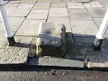
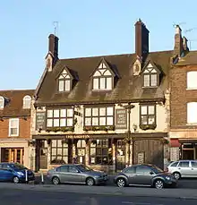
John Heathfield of the Friern Barnet & District Local History Society writes that according to the Royal Commission on the Historical Monuments of England, the stone outside The Griffin public house commonly known as the Whetstone, is a mounting block, and if so "it would have been connected to the toll gate erected by the Whetstone & Highgate Turnpike Trust about 1730."
He also states that the earliest evidence for the existence of the stone is a photograph taken in 1861 which shows it much closer to The Griffin than it is now. The stone was moved to its present location when the toll gate was removed in 1863.[2]
Until the late 19th century this was the northern hamlet, centred on a crossroads, of the medieval parish of Friern Barnet which stretched 3 miles (4.8 km) south-southeast and was half as wide as long. The very rural parish until then had one other main population centre, equally a hamlet, Colney Hatch.[3]
Geography
Neighbouring areas | |
|---|---|
See also
References
- "Living in Whetstone". Retrieved 14 November 2013.
- "Whetstone Notes", John Heathfield, Friern Barnet Newsletter, No. 57 (April 2014), p. 4.
- A P Baggs, Diane K Bolton, M A Hicks and R B Pugh, 'Friern Barnet: Introduction', in A History of the County of Middlesex: Volume 6 ed. T F T Baker and C R Elrington (London, 1980), pp. 6-15. Part of the Victoria County History collaborative professional historians' project. British History Online http://www.british-history.ac.uk/vch/middx/vol6/pp6-15
External links
![]() Media related to Whetstone, London at Wikimedia Commons
Media related to Whetstone, London at Wikimedia Commons