Administrative divisions of the Republic of Artsakh
The administrative divisions of the Republic of Artsakh are of two types; provinces and cities. There are seven provinces and one special administrative city - the capital of the Republic.[1]
| Regions of the Republic of Artsakh Շրջանները Լեռնային Ղարաբաղի Հանրապետության (Armenian) | |
|---|---|
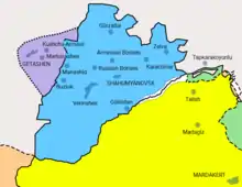
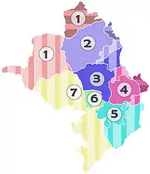 Provinces of the Republic of Artsakh prior to the 2020 war. Solid colors: Soviet-era NKAO; vertical stripes: not part of NKAO, Artsakh-ruled; horizontal stripes: Azerbaijani-ruled, claimed by Artsakh
| |
| Category | Unitary state |
| Location | Republic of Artsakh |
| Number | 7 Provinces 1 Special status city |
| Populations | 2,560 (Shahumyan) – 49,986 (Stepanakert) |
| Areas | 26 km2 (9.9 sq mi) (Stepanakert) – 3,380 km2 (1,304 sq mi) (Kashatagh) |
| Government | Region government, National government |
| Subdivisions | Urban community, Rural community |
Municipalities in Artsakh are divided into 2 categories: urban communities and rural communities. Prior to the 2020 war, there were 10 towns (urban) and 322 villages (rural) in Artsakh.[2]
Administrative divisions
| Province | Population (2005 census)[3] |
Area (km2) | Capital | Map |
|---|---|---|---|---|
| 1 Shahumyan Province1 | 2,560 | 1,830 | Karvachar | 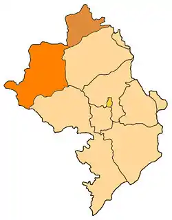 |
| 2 Martakert Province2 | 18,963 | 1,795 | Martakert | 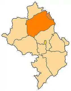 |
| 3 Askeran Province2 | 16,979 | 1,222 | Askeran |  |
| 4 Martuni Province2 | 23,158 | 951 | Martuni |  |
| 5 Hadrut Province1 | 12,005 | 1,877 | Hadrut |  |
| 6 Shushi Province2 | 4,324 | 383 | Shushi |  |
| 7 Kashatagh Province1 | 9,763 | 3,377 | Berdzor |  |
| 8 Stepanakert | 49,986 | 25.66 | Stepanakert | 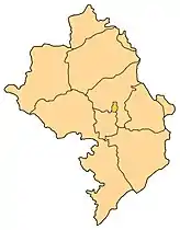 |
- 1 Totally under Azerbaijani control.
- 2 Partially under Azerbaijani control.
Azerbaijan divisions and claimed territories
Prior to the establishment of the Artsakh republic, the territory was organised by the Republic of Azerbaijan into a number of rayons (districts). Artsakh extended its provinces across the border of the former Nagorno-Karabakh Autonomous Oblast (NKAO), removing the administrative distinction between the two areas.[4] The following districts, which were not part of the NKAO but were in Azerbaijan proper, were completely within the de facto borders of Artsakh prior to the 2020 Nagorno-Karabakh war: Lachin, Qubadli, Zangilan, Jabrayil, Kalbajar. Additionally, parts of the following districts were partly under the control of Artsakh: Agdam District and Fuzuli District.
| Former Nagorno-Karabakh Autonomous Oblast | |||
|---|---|---|---|
| District (Rayon) | Area (km2) | Under NKR control (km2) | % |
| Askeran District | 928 | 928 | 100 |
| Hadrut District | 679 | 0 | 0 |
| Mardakert District | 1,705 | 1,305 | 76.5 |
| Martuni District | 792 | 632 | 79.8 |
| Shusha District | 280 | 224 | 80 |
| NKAO | 4,384 | 3,089 | 70.5 |
Pre-2020 war
Before the 2020 Nagorno-Karabakh war, districts of Azerbaijan surrounding Nagorno-Karabakh that were administered by Artsakh were: Lachin District, Qubadli District, Zangilan District, Jabrayil District and Kalbajar District, as well as parts of Agdam, and Fuzuli District. On the other hand, the eastern ends of Martakert and Martuni were under Azerbaijani control, as was the whole of Shahumian.
| Former Nagorno-Karabakh Autonomous Oblast | |||
|---|---|---|---|
| District (Rayon) | Area (km2) | Under NKR control (km2) | % |
| Askeran District | 928 | 928 | 100 |
| Hadrut District | 679 | 679 | 100 |
| Mardakert District | 1,705 | 1,305 | 76.5 |
| Martuni District | 792 | 632 | 79.8 |
| Shusha District | 280 | 280 | 100 |
| NKAO | 4,384 | 3,824 | 87.2 |
| Rayons of Azerbaijan SSR other than in NKAO | |||
| Southern part of Goranboy District | 558 | 0 | 0 |
| Kalbajar District | 1,936 | 1,936 | 100 |
| Lachin District | 1,835 | 1,835 | 100 |
| Qubadli District | 802 | 802 | 100 |
| Zangilan District | 707 | 707 | 100 |
| Jabrayil District | 1,050 | 1,050 | 100 |
| Fuzuli District | 1,390 | 462 | 33.2 |
| Agdam District | 1,150 | 842 | 73.2 |
| Azerbaijan | 8,870 | 7,634 | 86.1 |
See also
References
- NKR regions
- Administrative Territorial System of the Nagorno Karabagh Republic
- NKR official census of 2005
- Toal, Gerard; O'Loughlin, John (5 November 2013). "Land for Peace in Nagorny Karabakh? Political Geographies and Public Attitudes Inside a Contested De Facto State". Territory, Politics, Governance. 1 (2): 158–182. doi:10.1080/21622671.2013.842184. S2CID 54576963. Retrieved 27 November 2020.
| Capital city | ||
|---|---|---|
| Provinces | ||
| Provincial capitals | ||
| Other urban communities |
| |