1881 Minnesota tornado outbreak
The 1881 Minnesota tornado outbreak was a deadly tornado outbreak that struck southern Minnesota on July 15–16, 1881. At least six tornadoes touched down between 2:00 pm – 6:00 pm CST, killing 24 people and injuring at least 123.[1] The deadliest tornado of the outbreak, an F4 that killed 20 people in and near New Ulm, was likely a tornado family that may have caused F5 damage to rural farmsteads. Six people died in New Ulm, where people from nearby settlements had congregated to avoid Native American attacks.[1]
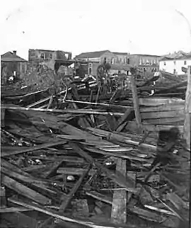
 Damage to New Ulm after the tornado | |
| Type | Tornado outbreak |
|---|---|
| Duration | July 15–16, 1881 |
| Tornadoes confirmed | ≥ 6 |
| Max. rating1 | F4 tornado |
| Duration of tornado outbreak2 | 4 hours |
| Casualties | 24 deaths, ≥ 123 injuries |
| 1Most severe tornado damage; see Fujita scale 2Time from first tornado to last tornado | |
Confirmed tornadoes
| FU | F0 | F1 | F2 | F3 | F4 | F5 | Total |
|---|---|---|---|---|---|---|---|
| 0 | ? | ? | 3 | 1 | 2 | 0 | ≥6 |
July 15 event
| F# | Location | County | Time (UTC) | Path length | Damage | |
|---|---|---|---|---|---|---|
| Minnesota | ||||||
| F4 | SE of Ortonville to N of Appleton | Lac Qui Parle, Big Stone, Swift | 2000 | 30 miles (48 km) | 4 deaths – This long-lived, violent tornado may have first developed across the Minnesota–South Dakota state line in South Dakota.[1] It caused damage to six farms southeast of Odessa, but with no deaths. It leveled numerous farms near Odessa and Correll before killing four people in and near Fairfield in Swift County.[1] | |
| F4 | W of Bird Island to S of New Ulm | Renville, Sibley, Nicollet, Brown | 2130 | 40 miles (64 km) | 20 deaths – An "extremely violent" tornado family, likely of F5 intensity, devastated farms and the west side of New Ulm.[1] The tornado struck five farms in Wellington Township, obliterating every building on each of them and causing two deaths. The tornado killed five additional people in Cairo Township, all in one family.[1] On the Minnesota River, the tornado razed nine homes in West Newton, where five more people died. Observers reported two parallel damage swaths nearby, indicating two or more tornadoes in the area and possible reformation into a distinct event.[1] Next, the tornado veered sharply to the left as it entered the west side of New Ulm, destroying that section of town, demolishing 47 structures, and killing six people. The town was hard hit, with 247 buildings damaged or destroyed. Six of the fatalities occurred in the town itself.[1][2] | |
| F2 | S of Sleepy Eye | Brown, Watonwan | 2250 | 8 miles (13 km) | A tornado leveled barns and snapped or uprooted trees.[1] | |
| F2 | N of Winnebago | Blue Earth, Faribault | 0000 | 5 miles (8.0 km) | A tornado hit and destroyed 12 farm buildings, including three or more barns.[1] | |
| F3 | S of Mountain Lake to W of Odin | Cottonwood, Watonwan | 0010 | 8 miles (13 km) | A tornado touched down near Mountain Lake, eliminating cattle and nearly leveling a farm; only a wall remained on the foundation. The tornado also tore off roofs from four other farmhouses.[1] | |
| Sources: Grazulis[1] | ||||||
References
- Grazulis 1993, p. 612
- Seely 2006, p. 183
Bibliography
- Grazulis, Thomas (1993), Significant Tornadoes 1680-1991: A Chronology and Analysis of Events, St. Johnsbury, Vermont: Environmental Films, ISBN 1-879362-03-1
- Seely, Mark W. (2006), Minnesota Weather Almanac (1st ed.), Minnesota Historical Society Press, ISBN 0-87351-554-4
External links
- Minnesota Tornado History and Statistics
- Gendisasters.com Archived 2012-09-19 at the Wayback Machine
This article is issued from Wikipedia. The text is licensed under Creative Commons - Attribution - Sharealike. Additional terms may apply for the media files.