Renville County, Minnesota
Renville County is a county in the U.S. state of Minnesota. As of the 2010 United States Census the population was 15,730.[1] Its county seat is Olivia.[2]
Renville County | |
|---|---|
 | |
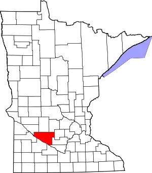 Location within the U.S. state of Minnesota | |
 Minnesota's location within the U.S. | |
| Coordinates: 44°43′N 94°58′W | |
| Country | |
| State | |
| Founded | February 20, 1855 (created) November 8, 1866 (organized) |
| Named for | Joseph Renville |
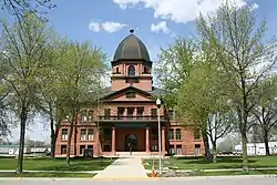
| Seat | Olivia |
| Largest city | Olivia |
| Area | |
| • Total | 987 sq mi (2,560 km2) |
| • Land | 983 sq mi (2,550 km2) |
| • Water | 4.2 sq mi (11 km2) 0.4%% |
| Population (2010) | |
| • Total | 15,730 |
| • Estimate (2019) | 14,548 |
| • Density | 14.9/sq mi (5.8/km2) |
| Time zone | UTC−6 (Central) |
| • Summer (DST) | UTC−5 (CDT) |
| Congressional district | 7th |
| Website | www |
History
The Minnesota Territory legislature created the county on February 20, 1855. It was named for Joseph Renville, a fur trapper, trader, British officer in the War of 1812, and interlocutor with local Native American groups. Organization of the county's governing structure was completed on November 8, 1866, with Beaver Falls as county seat. Beginning in 1885, citizens in and around Olivia began pressing for the seat to be moved to Olivia, which happened in 1900.[3]
Renville County was the site of several engagements in the Dakota War of 1862, most notably the Battle of Birch Coulee. The burned-out Joseph Brown House Ruins still stand, and various monuments throughout the County memorialize settlers killed in the conflict.
Geography
The Minnesota River flows southeast along the county's southwestern border. Hawk Creek flows south through the county's western end, discharging into the Minnesota. Beaver Creek drains the central part of the county, flowing southeast before turning southwest to discharge into the Minnesota. The county terrain consists of rolling hills etched by drainages and sprinkled with lakes and ponds. The area is devoted to agriculture.[4] The county terrain slopes to the south, with its highest point near the midpoint of the northern border, at 1,122' (342m) ASL.[5] The county has a total area of 987 square miles (2,560 km2), of which 983 square miles (2,550 km2) is land and 4.2 square miles (11 km2) (0.4%) is water.[6]
Major highways
 U.S. Highway 71
.svg.png.webp) U.S. Highway 212
U.S. Highway 212 Minnesota State Highway 4
 Minnesota State Highway 19
 Minnesota State Highway 23
Adjacent counties
- Kandiyohi County - north
- Meeker County - northeast
- McLeod County - east
- Sibley County - southeast
- Nicollet County - southeast
- Brown County - south
- Redwood County - southwest
- Yellow Medicine County - west
- Chippewa County - northwest
Renville, Beltrami, and Stearns are Minnesota's only counties that abut nine other counties.
Lakes[4]
- Beckendorf Lake
- Boon Lake
- Hodgson Lake
- Lake Allie
- Mud Lake
- Phare Lake
- Preston Lake
- Round Grove Lake (part)
- Round Lake
Protected areas[4]
- Beaver Falls County Park
- Camp Town Park
- County Park No. 2
- County Park No. 4
- Fort Ridgely State Park (part)
- Prieve State Wildlife Management Area (part)
- Skalbekken County Park
Demographics
| Historical population | |||
|---|---|---|---|
| Census | Pop. | %± | |
| 1860 | 245 | — | |
| 1870 | 3,219 | 1,213.9% | |
| 1880 | 10,791 | 235.2% | |
| 1890 | 17,099 | 58.5% | |
| 1900 | 23,693 | 38.6% | |
| 1910 | 23,123 | −2.4% | |
| 1920 | 23,634 | 2.2% | |
| 1930 | 23,645 | 0.0% | |
| 1940 | 24,625 | 4.1% | |
| 1950 | 23,954 | −2.7% | |
| 1960 | 23,249 | −2.9% | |
| 1970 | 21,139 | −9.1% | |
| 1980 | 20,401 | −3.5% | |
| 1990 | 17,673 | −13.4% | |
| 2000 | 17,154 | −2.9% | |
| 2010 | 15,730 | −8.3% | |
| 2019 (est.) | 14,548 | [8] | −7.5% |
| US Decennial Census[9] 1790-1960[10] 1900-1990[11] 1990-2000[12] 2010-2019[1] | |||
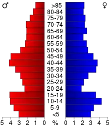
2000 census
As of the 2000 United States Census, there were 17,154 people, 6,779 households, and 4,623 families in the county. The population density was 17.5/sqmi (6.74/km2). There were 7,413 housing units at an average density of 7.54/sqmi (2.91/km2). The racial makeup of the county was 95.72% White, 0.06% Black or African American, 0.51% Native American, 0.20% Asian, 0.02% Pacific Islander, 2.77% from other races, and 0.73% from two or more races. 5.11% of the population were Hispanic or Latino of any race. 50.9% were of German, 16.3% Norwegian and 5.1% Swedish ancestry.
There were 6,779 households, out of which 31.50% had children under the age of 18 living with them, 59.10% were married couples living together, 5.60% had a female householder with no husband present, and 31.80% were non-families. 28.50% of all households were made up of individuals, and 15.10% had someone living alone who was 65 years of age or older. The average household size was 2.48 and the average family size was 3.05.
The county population contained 26.50% under the age of 18, 6.60% from 18 to 24, 25.30% from 25 to 44, 21.70% from 45 to 64, and 19.80% who were 65 years of age or older. The median age was 40 years. For every 100 females there were 99.30 males. For every 100 females age 18 and over, there were 98.50 males.
The median income for a household in the county was $37,652, and the median income for a family was $45,065. Males had a median income of $30,473 versus $22,179 for females. The per capita income for the county was $17,770. About 6.30% of families and 8.80% of the population were below the poverty line, including 10.80% of those under age 18 and 8.10% of those age 65 or over.
Communities
Cities
- Bird Island
- Buffalo Lake
- Danube
- Fairfax
- Franklin
- Hector
- Morton
- Olivia (county seat)
- Renville
- Sacred Heart
Unincorporated communities
Ghost towns
Townships
- Bandon Township
- Beaver Falls Township
- Birch Cooley Township
- Bird Island Township
- Boon Lake Township
- Brookfield Township
- Cairo Township
- Camp Township
- Crooks Township
- Emmet Township
- Ericson Township
- Flora Township
- Hawk Creek Township
- Hector Township
- Henryville Township
- Kingman Township
- Martinsburg Township
- Melville Township
- Norfolk Township
- Osceola Township
- Palmyra Township
- Preston Lake Township
- Sacred Heart Township
- Troy Township
- Wang Township
- Wellington Township
- Winfield Township
Politics
Before 1996, Renville County was a fairly balanced precinct. Since 1996, only Republican Party candidates have received the county vote in national elections (as of 2016).
| Year | Republican | Democratic | Third parties |
|---|---|---|---|
| 2016 | 64.3% 4,890 | 27.8% 2,117 | 7.9% 599 |
| 2012 | 53.8% 4,149 | 44.0% 3,394 | 2.2% 167 |
| 2008 | 48.6% 3,956 | 48.0% 3,904 | 3.4% 275 |
| 2004 | 53.1% 4,430 | 45.4% 3,787 | 1.6% 132 |
| 2000 | 49.7% 4,036 | 43.5% 3,533 | 6.8% 553 |
| 1996 | 35.0% 2,887 | 48.0% 3,956 | 16.9% 1,395 |
| 1992 | 32.0% 2,852 | 38.3% 3,414 | 29.8% 2,654 |
| 1988 | 48.8% 4,356 | 49.9% 4,454 | 1.3% 117 |
| 1984 | 57.9% 5,571 | 41.3% 3,972 | 0.9% 86 |
| 1980 | 53.1% 5,544 | 38.9% 4,058 | 8.1% 842 |
| 1976 | 42.5% 4,482 | 54.6% 5,762 | 2.9% 301 |
| 1972 | 53.1% 5,329 | 44.8% 4,499 | 2.2% 216 |
| 1968 | 48.7% 4,821 | 45.8% 4,535 | 5.6% 550 |
| 1964 | 41.6% 4,340 | 58.2% 6,072 | 0.2% 25 |
| 1960 | 54.2% 5,885 | 45.7% 4,958 | 0.1% 14 |
| 1956 | 57.5% 5,728 | 42.3% 4,213 | 0.2% 17 |
| 1952 | 63.5% 6,742 | 36.0% 3,828 | 0.5% 56 |
| 1948 | 44.4% 4,297 | 54.0% 5,227 | 1.6% 155 |
| 1944 | 57.5% 5,160 | 41.7% 3,747 | 0.8% 69 |
| 1940 | 57.2% 6,196 | 42.3% 4,588 | 0.5% 58 |
| 1936 | 32.3% 3,049 | 56.5% 5,344 | 11.2% 1,060 |
| 1932 | 30.0% 2,631 | 68.1% 5,967 | 1.9% 163 |
| 1928 | 57.2% 5,107 | 41.8% 3,731 | 1.1% 94 |
| 1924 | 42.7% 3,405 | 8.0% 641 | 49.3% 3,935 |
| 1920 | 73.6% 5,995 | 15.8% 1,283 | 10.6% 863 |
| 1916 | 55.3% 2,432 | 37.7% 1,660 | 7.0% 310 |
| 1912 | 18.0% 703 | 33.6% 1,310 | 48.4% 1,889 |
| 1908 | 60.2% 2,275 | 36.1% 1,364 | 3.7% 139 |
| 1904 | 77.9% 2,925 | 17.0% 639 | 5.0% 189 |
| 1900 | 64.8% 2,809 | 30.6% 1,326 | 4.7% 202 |
| 1896 | 55.2% 2,553 | 42.7% 1,978 | 2.1% 97 |
| 1892 | 40.0% 1,370 | 28.7% 984 | 31.4% 1,075 |
References
- "State & County QuickFacts". United States Census Bureau. Retrieved September 1, 2013.
- "Find a County". National Association of Counties. Retrieved June 7, 2011.
- Upham, Warren. Minnesota Place Names (1920) p. 455 (accessed April 5, 2019)
- Renville County MN Google Maps (accessed 5 April 2019)
- "Find an Altitude/Renville County MN" Google Maps (accessed 5 April 2019)
- "2010 Census Gazetteer Files". US Census Bureau. August 22, 2012. Archived from the original on September 21, 2013. Retrieved October 24, 2014.
- Nelson, Steven (2011). Savanna Soils of Minnesota. Minnesota: Self. pp. 65-67. ISBN 978-0-615-50320-2.
- "Population and Housing Unit Estimates". Retrieved March 26, 2020.
- "US Decennial Census". US Census Bureau. Retrieved October 24, 2014.
- "Historical Census Browser". University of Virginia Library. Retrieved October 24, 2014.
- "Population of Counties by Decennial Census: 1900 to 1990". US Census Bureau. Retrieved October 24, 2014.
- "Census 2000 PHC-T-4. Ranking Tables for Counties: 1990 and 2000" (PDF). US Census Bureau. Retrieved October 24, 2014.
- Leip, David. "Atlas of US Presidential Elections". uselectionatlas.org. Retrieved October 10, 2018.
External links
Places adjacent to Renville County, Minnesota | ||||||||||
|---|---|---|---|---|---|---|---|---|---|---|
| ||||||||||
Municipalities and communities of Renville County, Minnesota, United States | ||
|---|---|---|
| Cities | Map of Minnesota highlighting Renville County | |
| Townships | ||
| Unincorporated communities | ||
| Ghost town | ||
| Footnotes | ‡This populated place also has portions in an adjacent county or counties | |
| ||

| Authority control |
|---|