Brown County, Minnesota
Brown County is a county in the U.S. state of Minnesota. As of the 2010 United States Census, the population was 25,893.[2] Its county seat is New Ulm.[3] The county was formed in 1855 and organized in 1856.
Brown County | |
|---|---|
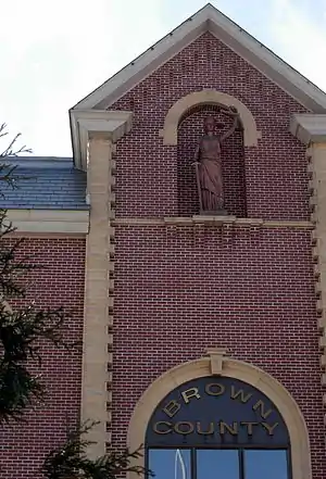 Brown County Courthouse | |
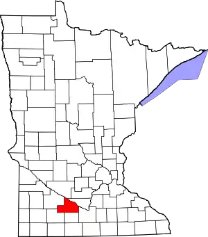 Location within the U.S. state of Minnesota | |
 Minnesota's location within the U.S. | |
| Coordinates: 44°14′N 94°43′W | |
| Country | |
| State | |
| Founded | February 20, 1855 (created) 1856 (organized)[1] |
| Named for | Joseph Renshaw Brown |
| Seat | New Ulm |
| Largest city | New Ulm |
| Area | |
| • Total | 618 sq mi (1,600 km2) |
| • Land | 611 sq mi (1,580 km2) |
| • Water | 7.4 sq mi (19 km2) 1.2%% |
| Population (2010) | |
| • Total | 25,893 |
| • Estimate (2019) | 25,008 |
| • Density | 41.2/sq mi (15.9/km2) |
| Time zone | UTC−6 (Central) |
| • Summer (DST) | UTC−5 (CDT) |
| Congressional district | 1st |
| Website | www |
Brown County comprises the New Ulm, MN Metropolitan Statistical Area and is included in the Mankato-New Ulm-North Mankato, MN Combined Statistical Area.
History
Brown County was founded in 1855. It was named for Joseph Renshaw Brown, a member of the Governor's Council of Minnesota in 1855.[4]
Geography
The Minnesota River flows east-southeast along the county's northern border. The Cottonwood River flows east-northeast through the county's central and upper area, discharging into the Minnesota at the northern border. The Little Cottonwood River flows east through the lower portion of the county, on its way to discharge into the Minnesota in neighboring Blue Earth County. The terrain consists of rolling hills, mostly devoted to agriculture,[5] and generally slopes to the east, tending to drop into the river valleys. Its highest point is at its southwestern corner, at 1,263' (385m) ASL.[6][7]
The county has a total area of 618 square miles (1,600 km2), of which 611 square miles (1,580 km2) is land and 7.4 square miles (19 km2) (1.2%) is water.[8][9]
Major highways
Adjacent counties
- Nicollet County - northeast
- Blue Earth County - southeast
- Watonwan County - south
- Cottonwood County - southwest
- Redwood County - west
- Renville County - northwest
Lakes
Most of the county is an area of rich farm land; most of its wetlands were drained for use in agriculture, leaving a number of lakes.[11] The county has at least 32 lakes,[12] some of which are deemed to be "protected waters" of the State of Minnesota;[13] these are designated with "(p)" below.
The lakes occupy "hollows in the driftsheet"; many have neither an inflow nor an outflow.[14]
Lakes in the county include:
- Altermatt Lake (p)
- Bachelor Lake (p), in Stark township
- Boise Lake (p)
- Clear Lake (p)
- Gilman Lake (p)
- Horseshoe Lake
- Juni Lake (p), named for Benedict Juni, a Swiss settler.[15]
- Lake Cottonwood (p)
- Lake Hanska (p)
- Linden Lake (p)
- Lone Tree Lake (p)
- Omsrud Lake (p)
- School Lake (p), named for its location in school section 16.[15]:72
- Sleepy Eye Lake (p)
- Zanders Lake (p)
Climate and weather
| New Ulm, Minnesota | ||||||||||||||||||||||||||||||||||||||||||||||||||||||||||||
|---|---|---|---|---|---|---|---|---|---|---|---|---|---|---|---|---|---|---|---|---|---|---|---|---|---|---|---|---|---|---|---|---|---|---|---|---|---|---|---|---|---|---|---|---|---|---|---|---|---|---|---|---|---|---|---|---|---|---|---|---|
| Climate chart (explanation) | ||||||||||||||||||||||||||||||||||||||||||||||||||||||||||||
| ||||||||||||||||||||||||||||||||||||||||||||||||||||||||||||
| ||||||||||||||||||||||||||||||||||||||||||||||||||||||||||||
In recent years, average temperatures in the county seat of New Ulm have ranged from a low of 6 °F (−14 °C) in January to a high of 83 °F (28 °C) in July, although a record low of −37 °F (−38 °C) was recorded in January 1984 and a record high of 105 °F (41 °C) was recorded in July 1988. Average monthly precipitation ranged from 0.64 inches (16 mm) in January to 4.82 inches (122 mm) in June.[16]
Demographics
| Historical population | |||
|---|---|---|---|
| Census | Pop. | %± | |
| 1860 | 2,339 | — | |
| 1870 | 6,396 | 173.5% | |
| 1880 | 12,018 | 87.9% | |
| 1890 | 15,817 | 31.6% | |
| 1900 | 19,787 | 25.1% | |
| 1910 | 20,134 | 1.8% | |
| 1920 | 22,421 | 11.4% | |
| 1930 | 23,428 | 4.5% | |
| 1940 | 25,544 | 9.0% | |
| 1950 | 25,895 | 1.4% | |
| 1960 | 27,676 | 6.9% | |
| 1970 | 28,887 | 4.4% | |
| 1980 | 28,645 | −0.8% | |
| 1990 | 26,984 | −5.8% | |
| 2000 | 26,911 | −0.3% | |
| 2010 | 25,893 | −3.8% | |
| 2019 (est.) | 25,008 | [17] | −3.4% |
| US Decennial Census[18] 1790-1960[19] 1900-1990[20] 1990-2000[21] 2010-2019[2] | |||
2000 census
As of the 2000 United States Census,[22] there were 26,911 people, 10,598 households, and 7,164 families in the county. The population density was 44.0/sqmi (17.0/km2). There were 11,163 housing units at an average density of 18.3/sqmi (7.05/km2). The racial makeup of the county was 97.82% White, 0.10% Black or African American, 0.12% Native American, 0.41% Asian, 0.01% Pacific Islander, 0.91% from other races, and 0.63% from two or more races. 2.03% of the population were Hispanic or Latino of any race. 67.1% were of German and 9.6% Norwegian ancestry.
There were 10,598 households, out of which 31.50% had children under the age of 18 living with them, 57.30% were married couples living together, 6.90% had a female householder with no husband present, and 32.40% were non-families. 29.00% of all households were made up of individuals, and 14.30% had someone living alone who was 65 years of age or older. The average household size was 2.43 and the average family size was 3.00.
The county population contained 25.30% under the age of 18, 9.70% from 18 to 24, 25.60% from 25 to 44, 21.90% from 45 to 64, and 17.50% who were 65 years of age or older. The median age was 38 years. For every 100 females there were 98.20 males. For every 100 females age 18 and over, there were 95.90 males.
The median income for a household in the county was $39,800, and the median income for a family was $49,811. Males had a median income of $32,347 versus $23,918 for females. The per capita income for the county was $19,535. About 4.40% of families and 6.40% of the population were below the poverty line, including 7.00% of those under age 18 and 9.80% of those age 65 or over.
Communities
Cities
- Cobden
- Comfrey (partial)
- Evan
- Hanska
- New Ulm (county seat)
- Sleepy Eye
- Springfield
Census-designated place
Unincorporated communities
- Essig
- Godahl (partial)
- Leavenworth
Government and Politics
Brown County voters have traditionally voted Republican. In no national election since 1964 has the county selected the Democratic Party candidate (as of 2016)
| Year | Republican | Democratic | Third parties |
|---|---|---|---|
| 2016 | 63.2% 8,708 | 27.3% 3,763 | 9.5% 1,308 |
| 2012 | 57.0% 7,938 | 40.4% 5,630 | 2.6% 361 |
| 2008 | 54.7% 7,456 | 42.7% 5,809 | 2.6% 355 |
| 2004 | 60.9% 8,395 | 37.4% 5,158 | 1.6% 225 |
| 2000 | 57.4% 7,370 | 36.2% 4,650 | 6.3% 814 |
| 1996 | 45.2% 5,580 | 39.4% 4,864 | 15.5% 1,915 |
| 1992 | 39.6% 5,390 | 31.4% 4,278 | 29.0% 3,953 |
| 1988 | 56.7% 6,898 | 42.0% 5,109 | 1.4% 166 |
| 1984 | 64.7% 8,399 | 34.4% 4,469 | 0.8% 109 |
| 1980 | 57.0% 8,051 | 34.8% 4,915 | 8.2% 1,156 |
| 1976 | 53.3% 7,479 | 41.3% 5,792 | 5.5% 768 |
| 1972 | 61.2% 7,791 | 34.2% 4,347 | 4.6% 591 |
| 1968 | 57.0% 7,039 | 37.1% 4,585 | 5.9% 726 |
| 1964 | 49.0% 5,851 | 50.8% 6,069 | 0.1% 17 |
| 1960 | 56.9% 7,084 | 43.0% 5,353 | 0.1% 16 |
| 1956 | 72.0% 7,965 | 27.7% 3,067 | 0.2% 27 |
| 1952 | 72.1% 8,152 | 27.7% 3,129 | 0.2% 27 |
| 1948 | 50.6% 5,068 | 48.0% 4,804 | 1.4% 144 |
| 1944 | 70.5% 7,018 | 28.6% 2,842 | 0.9% 89 |
| 1940 | 66.7% 7,533 | 32.6% 3,678 | 0.8% 90 |
| 1936 | 26.1% 2,679 | 64.6% 6,637 | 9.3% 951 |
| 1932 | 22.6% 2,027 | 75.0% 6,716 | 2.4% 212 |
| 1928 | 40.1% 3,611 | 59.2% 5,341 | 0.7% 64 |
| 1924 | 31.9% 2,255 | 3.8% 270 | 64.3% 4,551 |
| 1920 | 80.7% 5,841 | 11.0% 796 | 8.3% 603 |
| 1916 | 59.7% 2,078 | 31.6% 1,101 | 8.7% 303 |
| 1912 | 14.9% 472 | 43.0% 1,359 | 42.1% 1,330 |
| 1908 | 45.2% 1,518 | 45.8% 1,536 | 9.0% 303 |
| 1904 | 68.4% 2,073 | 28.7% 869 | 2.9% 89 |
| 1900 | 52.1% 1,695 | 45.2% 1,471 | 2.8% 90 |
| 1896 | 53.4% 1,807 | 43.4% 1,469 | 3.2% 107 |
| 1892 | 38.5% 1,080 | 41.8% 1,174 | 19.7% 553 |
| Position | Name | District | Next Election | |
|---|---|---|---|---|
| Commissioner | David Borchert | District 1 | 2020 | |
| Commissioner | Anton Berg | District 2 | 2020 | |
| Commissioner | Scott Windschitl | District 3 | 2020 | |
| Commissioner | Dean Simonsen | District 4 | 2022 | |
| Commissioner | Jeffrey Veerkamp | District 5 | 2022 | |
| Position | Name | Affiliation | District | |
|---|---|---|---|---|
| Senate | Gary Dahms[25] | Republican | District 16 | |
| House of Representatives | Paul Torkenson[26] | Republican | District 16B | |
| Position | Name | Affiliation | District | |
|---|---|---|---|---|
| House of Representatives | Jim Hagedorn[27] | Republican | 1st | |
| Senate | Amy Klobuchar[28] | Democrat | N/A | |
| Senate | Tina Smith[29] | Democrat | N/A | |
Footnotes
- "Minnesota Place Names". Minnesota Historical Society. Archived from the original on October 29, 2014. Retrieved March 17, 2014.
- "State & County QuickFacts". United States Census Bureau. Archived from the original on July 7, 2011. Retrieved August 31, 2013.
- "Find a County". National Association of Counties. Archived from the original on May 31, 2011. Retrieved June 7, 2011.
- History of the Origin of the Place Names in Nine Northwestern States. 1908. p. 12.
- Brown County MN Google Maps (accessed March 5, 2019)
- ""Find an Altitude/Brown County MN" Google Maps (accessed March 5, 2019)". Archived from the original on May 21, 2019. Retrieved March 6, 2019.
- Brown County High Point, Minnesota. PeakBagger.com (accessed May 5, 2019)
- "2010 Census Gazetteer Files". US Census Bureau. August 22, 2012. Archived from the original on October 6, 2014. Retrieved October 5, 2014.
- Minnesota Atlas & Gazetteer. Yarmouth ME: DeLorme. 1994. pp. 21–22, 30–31. ISBN 0-89933-222-6.
- Nelson, Steven (2011). Savanna Soils of Minnesota. Minnesota: Self. pp. 65-67. ISBN 978-0-615-50320-2.
- "Stark Township". Retrieved January 2, 2010.
- "Brown County MN Lakes". Retrieved January 2, 2010.
- "Final Designation of Protected Waters and Wetlands Within Brown County, Minnesota" (PDF). Minnesota Department of Natural Resources DIVISION OF WATERS. p. 2. Retrieved January 2, 2010.
- Winchel & Upham 1884, p. 560.
- Upham, Warren (1920). Minnesota Geographic Names: Their Origin and Historic Significance. Minnesota Historical Society. p. 72.:72
- "Monthly Averages for New Ulm MN". The Weather Channel. Retrieved November 6, 2011.
- "Population and Housing Unit Estimates". Retrieved March 26, 2020.
- "US Decennial Census". US Census Bureau. Retrieved October 5, 2014.
- "Historical Census Browser". University of Virginia Library. Retrieved October 5, 2014.
- "Population of Counties by Decennial Census: 1900 to 1990". US Census Bureau. Retrieved October 5, 2014.
- "Census 2000 PHC-T-4. Ranking Tables for Counties: 1990 and 2000" (PDF). US Census Bureau. Retrieved October 5, 2014.
- "U.S. Census website". US Census Bureau. Retrieved January 31, 2008.
- Leip, David. "Atlas of US Presidential Elections". uselectionatlas.org. Retrieved April 17, 2018.
- User, Super. "County Commissioner". www.co.brown.mn.us. Retrieved June 25, 2020.
- "MN State Senate". www.senate.mn. Retrieved June 25, 2020.
- "Rep. Paul Torkelson (16B) - Minnesota House of Representatives". www.house.leg.state.mn.us. Retrieved June 25, 2020.
- "Representative Jim Hagedorn". Representative Jim Hagedorn. Retrieved June 25, 2020.
- "U.S. Senator Amy Klobuchar". www.klobuchar.senate.gov. Retrieved June 24, 2020.
- "Home". Senator Tina Smith. Retrieved June 24, 2020.
Further reading
- Louis Albert Fritsche, History of Brown County, Minnesota: Its People, Industries and Institutions. In Two Volumes. Indianapolis, IN: B.F. Bowen and Co., 1916.
External links
Places adjacent to Brown County, Minnesota | ||||||||||
|---|---|---|---|---|---|---|---|---|---|---|
| ||||||||||
Municipalities and communities of Brown County, Minnesota, United States | ||
|---|---|---|
| Cities | Map of Minnesota highlighting Brown County | |
| Townships | ||
| CDP | ||
| Unincorporated communities | ||
| Brown County Lakes | ||
| Footnotes | ‡This populated place also has portions in an adjacent county or counties | |
| ||

| Authority control |
|---|