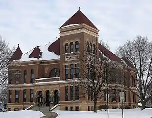
Watonwan County, Minnesota
Watonwan County is a county in the U.S. state of Minnesota. As of the 2010 United States Census, the population was 11,211.[2] Its county seat is St. James.[3]
Watonwan County | |
|---|---|
 | |
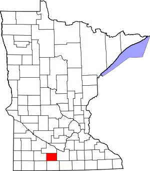 Location within the U.S. state of Minnesota | |
 Minnesota's location within the U.S. | |
| Coordinates: 43°59′N 94°37′W | |
| Country | |
| State | |
| Founded | February 25, 1860[1] |
| Named for | Watonwan River |
| Seat | St. James |
| Largest city | St. James |
| Area | |
| • Total | 440 sq mi (1,100 km2) |
| • Land | 435 sq mi (1,130 km2) |
| • Water | 4.8 sq mi (12 km2) 1.1%% |
| Population (2010) | |
| • Total | 11,211 |
| • Estimate (2019) | 10,897 |
| • Density | 25.2/sq mi (9.7/km2) |
| Time zone | UTC−6 (Central) |
| • Summer (DST) | UTC−5 (CDT) |
| Congressional district | 1st |
| Website | www |
History
In 1849 the recently organized Minnesota Territory legislature authorized the creation of nine large counties across the territory. In 1853, one of those original counties, Dakota, had a large partitioned off to create Blue Earth County. In 1855 the western part of Blue Earth was partitioned to create Brown County. Then on February 25, 1860, the south part of Brown was partitioned to create this county, with Madelia as the designated county seat. The county was named for its eponymous river, whose name reflects the Dakota word "watanwan," meaning "fish bait," or "plenty of fish."[4] The word first appears in the written record on an 1843 map of the area so naming the river.
In 1869 the first settlers arrived in the area of the future Saint James, and the area began growing. In 1870 an extension of the St. Paul and Sioux City Railway was terminated at the village, and railway officials decided to name the terminus Saint Paul. By 1878 the town had grown to the extent that a vote was taken to move the county seat there.[5]
Geography
The terrain of Watonwan County consists of low rolling hills, carved by drainages and dotted with lakes and ponds. The area is completely devoted to agriculture where possible.[7] The terrain slopes to the north and east, with its highest point near its southwest corner, at 1,293' (394m) ASL.[8] The county has a total area of 440 square miles (1,100 km2), of which 435 square miles (1,130 km2) is land and 4.8 square miles (12 km2) (1.1%) is water.[9] The county is drained by the Watonwan River and its tributaries; the river flows eastwardly through the northern part of the county.[10]
Major highways
Airports
- St. James Municipal Airport (JYG, LID) - 3 miles (5 km) east of St. James
Adjacent counties
- Brown County - north
- Blue Earth County - east
- Martin County - south
- Jackson County - southwest
- Cottonwood County - west
Protected areas[7]
- Bergdahl State Wildlife Management Area
- Lewisville State Wildlife Management Area
- Turtle Marsh State Wildlife Management Area
- Wilson State Wildlife Management Area
- Woodlake State Wildlife Management Area
Lakes[7]
- Bergdahl Lake
- Bullhead Lake
- Butterfield Lake
- Case Lake
- Cottonwood Lake
- Ewy Lake
- Fedji Lake
- Irish Lake
- Long Lake
- Mary Lake
- Mud Lake
- Kansas Lake
- Saint James Lake
- School Lake
- Sulem Lake
- Wilson Lake ("School Lake" in some records)
- Wood Lake (part)
Demographics
| Historical population | |||
|---|---|---|---|
| Census | Pop. | %± | |
| 1870 | 2,426 | — | |
| 1880 | 5,104 | 110.4% | |
| 1890 | 7,746 | 51.8% | |
| 1900 | 11,496 | 48.4% | |
| 1910 | 11,332 | −1.4% | |
| 1920 | 12,457 | 9.9% | |
| 1930 | 12,802 | 2.8% | |
| 1940 | 13,902 | 8.6% | |
| 1950 | 13,881 | −0.2% | |
| 1960 | 14,460 | 4.2% | |
| 1970 | 13,298 | −8.0% | |
| 1980 | 12,361 | −7.0% | |
| 1990 | 11,682 | −5.5% | |
| 2000 | 11,876 | 1.7% | |
| 2010 | 11,211 | −5.6% | |
| 2019 (est.) | 10,897 | [11] | −2.8% |
| US Decennial Census[12] 1790-1960[13] 1900-1990[14] 1990-2000[15] 2010-2019[2] | |||
2000 census
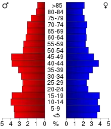
As of the 2000 United States Census, there were 11,876 people, 4,627 households, and 3,141 families in the county. The population density was 27.3/sqmi (10.5/km2). There were 5,036 housing units at an average density of 11.6/sqmi (4.47/km2). The racial makeup of the county was 88.54% White, 0.37% Black or African American, 0.21% Native American, 0.87% Asian, 0.02% Pacific Islander, 8.78% from other races, and 1.21% from two or more races. 15.19% of the population were Hispanic or Latino of any race. 40.9% were of German, 17.3% Norwegian and 5.8% Swedish ancestry.
There were 4,627 households, out of which 32.50% had children under the age of 18 living with them, 56.60% were married couples living together, 7.30% had a female householder with no husband present, and 32.10% were non-families. 28.70% of all households were made up of individuals, and 15.40% had someone living alone who was 65 years of age or older. The average household size was 2.53 and the average family size was 3.10.
The county population contained 27.60% under the age of 18, 7.80% from 18 to 24, 24.30% from 25 to 44, 21.70% from 45 to 64, and 18.60% who were 65 years of age or older. The median age was 39 years. For every 100 females there were 95.40 males. For every 100 females age 18 and over, there were 94.50 males.
The median income for a household in the county was $35,441, and the median income for a family was $42,321. Males had a median income of $29,242 versus $19,788 for females. The per capita income for the county was $16,413. About 7.80% of families and 9.80% of the population were below the poverty line, including 13.50% of those under age 18 and 8.80% of those age 65 or over.
Communities
Cities
- Butterfield
- Darfur
- La Salle
- Lewisville
- Madelia
- Odin
- Ormsby (partly in Martin County)
- St. James (county seat)
Unincorporated communities
- Echols
- Godahl (partial)
- Grogan
- South Branch
- Sveadahl
- Tenmile Corner
Government and Politics
Watonwan County voters tend to vote Republican. In two-thirds of national elections since 1980 the county has selected the Republican Party candidate (as of 2016).
| Year | Republican | Democratic | Third parties |
|---|---|---|---|
| 2016 | 55.4% 2,768 | 36.3% 1,814 | 8.3% 416 |
| 2012 | 48.9% 2,517 | 48.5% 2,494 | 2.6% 133 |
| 2008 | 48.0% 2,526 | 48.7% 2,562 | 3.2% 170 |
| 2004 | 53.2% 2,970 | 45.0% 2,514 | 1.8% 99 |
| 2000 | 49.9% 2,562 | 44.0% 2,258 | 6.1% 314 |
| 1996 | 37.7% 1,997 | 47.9% 2,534 | 14.4% 760 |
| 1992 | 33.5% 1,871 | 37.7% 2,100 | 28.8% 1,607 |
| 1988 | 52.1% 2,821 | 47.0% 2,544 | 0.9% 50 |
| 1984 | 59.0% 3,526 | 40.6% 2,425 | 0.5% 27 |
| 1980 | 55.1% 3,629 | 37.1% 2,442 | 7.8% 516 |
| 1976 | 50.3% 3,351 | 47.7% 3,177 | 2.0% 134 |
| 1972 | 63.4% 3,960 | 35.7% 2,229 | 1.0% 62 |
| 1968 | 53.6% 3,446 | 42.0% 2,701 | 4.4% 286 |
| 1964 | 43.8% 2,823 | 56.1% 3,615 | 0.1% 7 |
| 1960 | 63.3% 4,173 | 36.6% 2,412 | 0.2% 10 |
| 1956 | 67.6% 3,963 | 32.2% 1,886 | 0.2% 12 |
| 1952 | 72.0% 4,549 | 27.7% 1,752 | 0.2% 15 |
| 1948 | 45.3% 2,581 | 53.3% 3,039 | 1.4% 78 |
| 1944 | 57.3% 3,146 | 42.3% 2,324 | 0.4% 23 |
| 1940 | 55.3% 3,478 | 44.3% 2,783 | 0.5% 28 |
| 1936 | 33.4% 1,930 | 63.6% 3,668 | 3.0% 174 |
| 1932 | 39.6% 1,919 | 57.7% 2,795 | 2.7% 129 |
| 1928 | 69.7% 3,306 | 29.8% 1,412 | 0.6% 26 |
| 1924 | 53.6% 2,297 | 6.5% 279 | 39.9% 1,712 |
| 1920 | 81.4% 3,510 | 15.0% 647 | 3.6% 155 |
| 1916 | 59.9% 1,300 | 36.9% 801 | 3.1% 68 |
| 1912 | 12.2% 254 | 29.7% 618 | 58.0% 1,206 |
| 1908 | 70.4% 1,411 | 26.8% 537 | 2.8% 55 |
| 1904 | 80.0% 1,455 | 16.9% 307 | 3.2% 58 |
| 1900 | 71.9% 1,509 | 24.3% 509 | 3.8% 80 |
| 1896 | 72.0% 1,622 | 26.0% 586 | 2.0% 45 |
| 1892 | 62.7% 934 | 26.0% 388 | 11.3% 168 |
| Position | Name | District | Next Election | |
|---|---|---|---|---|
| Commissioner and Chairperson | Raymond Gustafson | District 1 | 2020 | |
| Commissioner | Bill Miller | District 2 | 2022 | |
| Commissioner | Jim Branstad | District 3 | 2020 | |
| Commissioner | Bob Rinne | District 4 | 2022 | |
| Commissioner | Kathleen Svalland | District 5 | 2020 | |
| Position | Name | Affiliation | District | |
|---|---|---|---|---|
| Senate | Julie Rosen[18] | Republican | District 23 | |
| House of Representatives | Bob Gunther[19] | Republican | District 23A | |
| House of Representatives | Jeremy Munson[20] | Republican | District 23B | |
| Position | Name | Affiliation | District | |
|---|---|---|---|---|
| House of Representatives | Jim Hagedorn[21] | Republican | 1st | |
| Senate | Amy Klobuchar[22] | Democrat | N/A | |
| Senate | Tina Smith[23] | Democrat | N/A | |
See also
- National Register of Historic Places listings in Watonwan County, Minnesota
Footnotes
- "Minnesota Place Names". Minnesota Historical Society. Retrieved March 19, 2014.
- "State & County QuickFacts". United States Census Bureau. Retrieved September 1, 2013.
- "Find a County". National Association of Counties. Retrieved June 7, 2011.
- Chicago and North Western Railway Company (1908). A History of the Origin of the Place Names Connected with the Chicago & North Western and Chicago, St. Paul, Minneapolis & Omaha Railways. p. 165.
- Upham, Warren. Minnesota Geographic Names (1920), pp. 547-76 (accessed April 22, 2019)
- Nelson, Steven (2011). Savanna Soils of Minnesota. Minnesota: Self. pp. 65-67. ISBN 978-0-615-50320-2.
- Watonwan County MN Google Maps (accessed 22 April 2019)
- "Find an Altitude/Watonwan County MN" Google Maps (accessed 22 April 2019)
- "2010 Census Gazetteer Files". US Census Bureau. August 22, 2012. Archived from the original on October 6, 2014. Retrieved October 25, 2014.
- Minnesota Atlas & Gazetteer. Yarmouth ME: DeLorme. 1994. pp. 21–22. ISBN 0-89933-222-6.
- "Population and Housing Unit Estimates". Retrieved March 26, 2020.
- "US Decennial Census". US Census Bureau. Retrieved October 25, 2014.
- "Historical Census Browser". University of Virginia Library. Retrieved October 25, 2014.
- "Population of Counties by Decennial Census: 1900 to 1990". US Census Bureau. Retrieved October 25, 2014.
- "Census 2000 PHC-T-4. Ranking Tables for Counties: 1990 and 2000" (PDF). US Census Bureau. Retrieved October 25, 2014.
- Leip, David. "Atlas of US Presidential Elections". uselectionatlas.org. Retrieved October 10, 2018.
- "County Board of Commissioners | Watonwan County, MN - Official Website". www.co.watonwan.mn.us. Retrieved 2020-06-26.
- "MN State Senate". www.senate.mn. Retrieved 2020-06-26.
- "Rep. Bob Gunther (23A) - Minnesota House of Representatives". www.house.leg.state.mn.us. Retrieved 2020-06-26.
- "Rep. Jeremy Munson (23B) - Minnesota House of Representatives". www.house.leg.state.mn.us. Retrieved 2020-06-26.
- "Representative Jim Hagedorn". Representative Jim Hagedorn. Retrieved 2020-06-25.
- "U.S. Senator Amy Klobuchar". www.klobuchar.senate.gov. Retrieved 2020-06-24.
- "Home". Senator Tina Smith. Retrieved 2020-06-24.
Further reading
- John A. Brown (ed.), History of Cottonwood and Watonwan counties, Minnesota: Their People, Industries, and Institutions: With Biographical Sketches of Representative Citizens and Genealogical Records of Many of the Old Families. In Two Volumes. Indianapolis, IN: B.F. Bowen and Company, 1916. Volume 1 | Volume 2
Places adjacent to Watonwan County, Minnesota | ||||||||||
|---|---|---|---|---|---|---|---|---|---|---|
| ||||||||||
Municipalities and communities of Watonwan County, Minnesota, United States | ||
|---|---|---|
| Cities | Map of Minnesota highlighting Watonwan County | |
| Townships | ||
| Unincorporated communities | ||
| Footnotes | ‡This populated place also has portions in an adjacent county or counties | |
| ||

| Authority control |
|---|