Alaminos, Laguna
Alaminos, officially the Municipality of Alaminos (Tagalog: Bayan ng Alaminos), is a 3rd class municipality in the province of Laguna, Philippines. According to the 2015 census, it has a population of 47,859 people. [3]
Alaminos | |
|---|---|
| Municipality of Alaminos | |
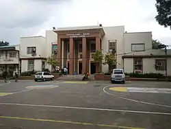
 Church and Municipal Hall | |
 Seal | |
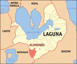 Map of Laguna with Alaminos highlighted | |
OpenStreetMap 
| |
.svg.png.webp) Alaminos Location within the Philippines | |
| Coordinates: 14°03′48″N 121°14′42″E | |
| Country | |
| Region | Calabarzon (Region IV-A) |
| Province | Laguna |
| District | 3rd District |
| Founded | January 1, 1916 |
| Barangays | 15 (see Barangays) |
| Government | |
| • Type | Sangguniang Bayan |
| • Mayor | Eladio M. Magampon |
| • Vice Mayor | Ruben D. Alvarez |
| • Representative | Marisol A. Sampelo |
| • Electorate | 29,636 voters (2019) |
| Area | |
| • Total | 57.46 km2 (22.19 sq mi) |
| Elevation | 176 m (577 ft) |
| Population | |
| • Total | 47,859 |
| • Density | 830/km2 (2,200/sq mi) |
| • Households | 11,025 |
| Economy | |
| • Income class | 3rd municipal income class |
| • Poverty incidence | 2.67% (2015)[4] |
| • Revenue | ₱117,064,001.83 (2016) |
| Time zone | UTC+8 (PST) |
| ZIP code | 4001 |
| PSGC | |
| IDD : area code | +63 (0)49 |
| Climate type | tropical monsoon climate |
| Native languages | Tagalog |
| Website | www |
The Municipality of Alaminos is an AGRO-INDUSTRIAL town that lies within the third congressional district of the Province of Laguna and is part of the CALABARZON. Based on the municipal zoning, the Industrial sites are located along Maharlika Highway of Barangays San Andres, San Juan, San Agustin and San Benito. Here, lands are available for Industrial and Commercial purposes. Barangays San Andres and San Juan will also be developed as technopark for farm housing, industrial and commercial purposes.
History
Alaminos began as a barrio of San Pablo City which was then only a town of the Province of Batangas. Its initial name was Trenchera denoting the presence of long and deep ravines. The early inhabitants of Trenchera were believed to be insurectors and possibly fugitives who took advantage of the numerous trenches for hiding as well as for defense against the Spanish authority.
Sometime in 1873 when a certain Don Andres Penaloza was the Gobernadorcillo (equivalent to Mayor) of the town of San Pablo, Trenchera was formally separated and became pueblo or town but remained part of the Province of Batangas. Don Cirilo Baylon, a wealthy resident of Trenchera and with good command of the Spanish language invited Captain-General Juan de Alaminos Nivera, the Chief Executive of the Province of Batangas whose capital seat was Lipa. The Captain-General accepted the invitation and came in colorful carriage drawn by two horses. With Don Cirilo Baylon leading, he was warmly received by the residents of Trenchera. Dona Gregoria Baylon, the younger sister of Don Cirilo Baylon presented bouquets of fresh flowers to the Captain-General.
During the program in honor of the Captain General and his party, Don Cirilo Baylon presented the petition of the residents asking that Trenchera be made into a duly organized and recognized town. The petition was read in public and the Captain General gave assurance to consider their wish favorably. In less than 2 months the official paper proclaiming Trenchera as a new pueblo or town arrived from Lipa.
At the same time, Don Cirilo Baylon was appointed the first Gobernadorcillo or Town Mayor in concurrent capacity as Capitan de los Constables de Pueblo or the equivalent of the local police chief. In appreciation of Capitan General Juan de Alaminos Nivera, the new pueblo was named Alaminos in 1873 and remained part of the Province of Batangas until 1903.
Geography
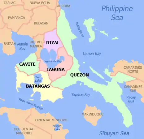
Alaminos has a land area of 5,476 hectares (13,530 acres) and is situated 73 kilometres (45 mi) southeast of Manila. The municipalities of Calauan and Bay are located north of Alaminos, the city of San Pablo on the south and east and the municipality of Santo Tomas in Batangas province on its west.[5]
There are three main rivers in Alaminos, namely Kaquinkong, Onipa and Tigas.[6]
The Maharlika Highway passes through the municipality and is connected directly to Manila through the South Luzon Expressway.[5]
Barangays
Alaminos is politically subdivided into 15 barangays. [2] Four are which is classified as urban barangays; Barangay I, II, III and IV. The rest of the eleven barangays are classified as rural. San Gregorio is the biggest barangay measuring 840.6190 hectares followed by Santa Rosa measuring 802.28 hectares.[5]
Climate
| Climate data for Alaminos, Laguna | |||||||||||||
|---|---|---|---|---|---|---|---|---|---|---|---|---|---|
| Month | Jan | Feb | Mar | Apr | May | Jun | Jul | Aug | Sep | Oct | Nov | Dec | Year |
| Average high °C (°F) | 26 (79) |
27 (81) |
29 (84) |
31 (88) |
31 (88) |
29 (84) |
28 (82) |
28 (82) |
28 (82) |
28 (82) |
27 (81) |
26 (79) |
28 (83) |
| Average low °C (°F) | 20 (68) |
20 (68) |
20 (68) |
21 (70) |
23 (73) |
23 (73) |
23 (73) |
23 (73) |
23 (73) |
22 (72) |
21 (70) |
21 (70) |
22 (71) |
| Average precipitation mm (inches) | 52 (2.0) |
35 (1.4) |
27 (1.1) |
27 (1.1) |
82 (3.2) |
124 (4.9) |
163 (6.4) |
144 (5.7) |
145 (5.7) |
141 (5.6) |
100 (3.9) |
102 (4.0) |
1,142 (45) |
| Average rainy days | 12.0 | 8.1 | 8.8 | 9.7 | 17.9 | 22.6 | 26.2 | 24.5 | 24.6 | 22.0 | 16.7 | 14.9 | 208 |
| Source: Meteoblue [7] | |||||||||||||
Demographics
| Year | Pop. | ±% p.a. |
|---|---|---|
| 1903 | 4,135 | — |
| 1918 | 6,739 | +3.31% |
| 1939 | 8,817 | +1.29% |
| 1948 | 9,518 | +0.85% |
| 1960 | 13,860 | +3.18% |
| 1970 | 16,649 | +1.85% |
| 1975 | 18,504 | +2.14% |
| 1980 | 20,615 | +2.18% |
| 1990 | 27,412 | +2.89% |
| 1995 | 31,442 | +2.60% |
| 2000 | 36,120 | +3.02% |
| 2007 | 40,380 | +1.55% |
| 2010 | 43,526 | +2.77% |
| 2015 | 47,859 | +1.82% |
| Source: Philippine Statistics Authority [3] [8] [9][10] | ||
In the 2015 census, the population of Alaminos, Laguna, was 47,859 people, [3] with a density of 830 inhabitants per square kilometre or 2,100 inhabitants per square mile.
Municipal Government
Mayors of Alaminos
The following is the list of mayors of Alaminos since 1944. Hernandez Sr. and Masa were appointed as Mayors. Donato died in office, with Vice Mayor Flores assuming the position of mayor following Donato's death.[11]
- Demetrio Hernandez Sr. (1944–1946)*
- Felimon Masa (1947–1948)
- Daniel Fandiño (1948–1951)
- Lorenzo Dimayuga (1952–1955)
- Pedro De Villa (1956–1963)
- Casimiro Faylona (1968–1971)
- Pedro De Villa (1968–1971)
- Armando M. Bueser (1972–1979)
- Francisco Donato (1980–1982)
- Mariano Flores (1982–1987)
- Samuel F. Bueser (1988–1998)
- Demetrio P. Hernandez Jr. (1998–2001)
- Samuel F. Bueser (May 14, 2001 – 2007)
- Eladio M. Magampon (2007–2016)
- Loreto M. Masa (2016–2019)
- Eladio M. Magampon (2019–present)
Culture
The religious patron of the town of Alaminos is the Nuestra Señora Del Pilar. On October 12 annually, the town fiesta of Alaminos is celebrated.[12]
Special Events/Festivals
Town Fiesta October 12
People from Alaminos
- Ariella Arida – Miss Universe 2013 3rd Runner-up and co-host of GMA 7 gameshow Wowowin
References
- Municipality of Alaminos | (DILG)
- "Province: Laguna". PSGC Interactive. Quezon City, Philippines: Philippine Statistics Authority. Retrieved 12 November 2016.
- Census of Population (2015). "Region IV-A (Calabarzon)". Total Population by Province, City, Municipality and Barangay. PSA. Retrieved 20 June 2016.
- "PSA releases the 2015 Municipal and City Level Poverty Estimates". Quezon City, Philippines. Retrieved 1 January 2020.
- "Location, Composition and Land Area". Alaminos, Laguna. Archived from the original on 14 December 2014. Retrieved 14 December 2014.
- "Drainage and River Networks". Alaminos, Laguna. Archived from the original on 14 December 2014. Retrieved 14 December 2014.
- "Alaminos: Average Temperatures and Rainfall". Meteoblue. Retrieved 11 May 2020.
- Census of Population and Housing (2010). "Region IV-A (Calabarzon)". Total Population by Province, City, Municipality and Barangay. NSO. Retrieved 29 June 2016.
- Censuses of Population (1903–2007). "Region IV-A (Calabarzon)". Table 1. Population Enumerated in Various Censuses by Province/Highly Urbanized City: 1903 to 2007. NSO.
- "Province of Laguna". Municipality Population Data. Local Water Utilities Administration Research Division. Retrieved 17 December 2016.
- "List of Mayors". Alaminos, Laguna. Archived from the original on 14 December 2014. Retrieved 14 December 2014.
- "History Of Alaminos". Alaminos, Laguna. Archived from the original on 14 December 2014. Retrieved 14 December 2014.
External links
| Wikimedia Commons has media related to Alaminos, Laguna. |
| Wikivoyage has a travel guide for Alaminos (Laguna). |
- Alaminos Profile at PhilAtlas.com
- Philippine Standard Geographic Code
- Philippine Census Information
- Local Governance Performance Management System
Places adjacent to Alaminos, Laguna | ||||||||||
|---|---|---|---|---|---|---|---|---|---|---|
| ||||||||||
Santa Cruz (capital) | ||
| Municipalities |  | |
| Component Cities | ||
| Barangays | ||