Mabitac
Mabitac, officially the Municipality of Mabitac (Tagalog: Bayan ng Mabitac), is a 5th class municipality in the province of Laguna, Philippines. According to the 2015 census, it has a population of 20,530 people. [3]
Mabitac | |
|---|---|
| Municipality of Mabitac | |
 Hilltop view of Mabitac | |
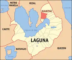 Map of Laguna with Mabitac highlighted | |
OpenStreetMap 
| |
.svg.png.webp) Mabitac Location within the Philippines | |
| Coordinates: 14°26′N 121°25′E | |
| Country | |
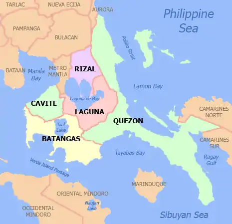
| Region | Calabarzon (Region IV-A) |
| Province | Laguna |
| District | 4th District |
| Founded | January 6, 1616 |
| Barangays | 15 (see Barangays) |
| Government | |
| • Type | Sangguniang Bayan |
| • Mayor | Ronald I. Sana |
| • Vice Mayor | Angelito V. Valderrama Sr. |
| • Representative | Benjamin C. Agarao Jr. |
| • Electorate | 14,602 voters (2019) |
| Area | |
| • Total | 80.76 km2 (31.18 sq mi) |
| Elevation | 128 m (420 ft) |
| Population | |
| • Total | 20,530 |
| • Density | 250/km2 (660/sq mi) |
| • Households | 4,490 |
| Economy | |
| • Income class | 5th municipal income class |
| • Poverty incidence | 16.91% (2015)[4] |
| • Revenue | ₱64,214,663.12 (2016) |
| Time zone | UTC+8 (PST) |
| ZIP code | 4020 |
| PSGC | |
| IDD : area code | +63 (0)49 |
| Climate type | tropical monsoon climate |
| Native languages | Tagalog |
| Website | www |
Mabitac was an excellent hunting ground for wild game three centuries ago. Native hunters used numerous cave-ins or trap-ins called "bitag" in the local dialect. Hence, the place was referred to as "Mabitag" meaning "a place with many traps".
Mabitac is situated on the eastern side of the province of Laguna, 88 kilometres (55 mi) from Manila using Rizal Province on a winding road of Manila East Road, and Antipolo City or 123 kilometres (76 mi) via the South Luzon Express, Calamba and Santa Cruz, Laguna.
History
The first Spaniards who came to this place were the friars who established the first Spanish settlement in the area and began to Christianize the local population. The Spaniards, having difficulty in pronouncing the "G" consonant, called this place "Mabitac" whenever they mentioned this place. Eventually, the name found its way in the official records and maps of Laguna made by Spanish cartographers and mariners who chartered the coastal areas of Laguna de Bay.
This town was formerly a barrio of Siniloan, an immediate neighboring town. It became an independent municipality only in the year 1611, not by legislation, but by mutual agreement by and between the Spanish friars of both towns who were then the influential ruling class.
Mabitac was the site of a battle in the Philippine–American War, when on September 17, 1900, Filipinos under General Juan Cailles defeated an American force commanded by Colonel Benjamin F. Cheatham.
Juan Cailles
Juan Cailles (born Juan Cailles y Kauppama; November 10, 1871 – June 28, 1951) was a Filipino of French-Indian descent. A member of the revolutionary movement Katipunan, he was a commanding officer of the Philippine Revolutionary Army who served during the Philippine Revolution and Philippine–American War. He later served as a provincial Governor of Laguna and a member of the Philippine Legislature.
Japanese occupation of the Philippines
The Japanese occupation of the Philippines (Filipino: Pananakop ng mga Hapones sa Pilipinas; Japanese: 日本のフィリピン占領; Hepburn: Nihon no Firipin Senryō) occurred between 1942 and 1945, when Imperial Japan occupied the Commonwealth of the Philippines during World War II.
The invasion of the Philippines started on 8 December 1941, ten hours after the attack on Pearl Harbor. As at Pearl Harbor, American aircraft were severely damaged in the initial Japanese attack. Lacking air cover, the American Asiatic Fleet in the Philippines withdrew to Java on 12 December 1941. General Douglas MacArthur was ordered out, leaving his men at Corregidor on the night of 11 March 1942 for Australia, 4,000 km away. The 76,000 starving and sick American and Filipino defenders in Bataan surrendered on 9 April 1942, and were forced to endure the infamous Bataan Death March on which 7,000–10,000 died or were murdered. The 13,000 survivors on Corregidor surrendered on 6 May.
Japan occupied the Philippines for over three years, until the surrender of Japan. A highly effective guerilla campaign by Philippine resistance forces controlled sixty percent of the islands, mostly jungle and mountain areas. MacArthur supplied them by submarine, and sent reinforcements and officers. Filipinos remained loyal to the United States, partly because of the American guarantee of independence, and also because the Japanese had pressed large numbers of Filipinos into work details and even put young Filipino women into brothels.
General MacArthur kept his promise to return to the Philippines on 20 October 1944. The landings on the island of Leyte were accompanied by a force of 700 vessels and 174,000 men. Through December 1944, the islands of Leyte and Mindoro were cleared of Japanese soldiers. During the campaign, the Imperial Japanese Army conducted a suicidal defense of the islands. Cities such as Manila were reduced to rubble. Around 500,000 Filipinos died during the Japanese Occupation Period.
In 1942, Japanese soldiers entered and occupied Mabitac . In 1945, the Philippine Commonwealth Army troops of the 4th, 42nd and 43rd Infantry Division and 4th Constabulary Regiment of the Philippine Constabulary together with the recognized guerrillas defeated the Japanese Imperial forces during the Second Battle of Mabitac.
Barangays
Climate
| Climate data for Mabitac, Laguna | |||||||||||||
|---|---|---|---|---|---|---|---|---|---|---|---|---|---|
| Month | Jan | Feb | Mar | Apr | May | Jun | Jul | Aug | Sep | Oct | Nov | Dec | Year |
| Average high °C (°F) | 26 (79) |
27 (81) |
29 (84) |
31 (88) |
31 (88) |
30 (86) |
29 (84) |
29 (84) |
29 (84) |
29 (84) |
28 (82) |
26 (79) |
29 (84) |
| Average low °C (°F) | 22 (72) |
22 (72) |
22 (72) |
23 (73) |
24 (75) |
25 (77) |
24 (75) |
24 (75) |
24 (75) |
24 (75) |
24 (75) |
23 (73) |
23 (74) |
| Average precipitation mm (inches) | 58 (2.3) |
41 (1.6) |
32 (1.3) |
29 (1.1) |
91 (3.6) |
143 (5.6) |
181 (7.1) |
162 (6.4) |
172 (6.8) |
164 (6.5) |
113 (4.4) |
121 (4.8) |
1,307 (51.5) |
| Average rainy days | 13.4 | 9.3 | 9.1 | 9.8 | 19.1 | 22.9 | 26.6 | 24.9 | 25.0 | 21.4 | 16.5 | 16.5 | 214.5 |
| Source: Meteoblue[5] | |||||||||||||
Demographics
| Year | Pop. | ±% p.a. |
|---|---|---|
| 1903 | 1,052 | — |
| 1918 | 760 | −2.14% |
| 1939 | 1,973 | +4.65% |
| 1948 | 2,700 | +3.55% |
| 1960 | 4,316 | +3.99% |
| 1970 | 6,377 | +3.98% |
| 1975 | 7,415 | +3.07% |
| 1980 | 8,543 | +2.87% |
| 1990 | 11,444 | +2.97% |
| 1995 | 13,309 | +2.87% |
| 2000 | 15,097 | +2.74% |
| 2007 | 17,608 | +2.14% |
| 2010 | 18,618 | +2.05% |
| 2015 | 20,530 | +1.88% |
| Source: Philippine Statistics Authority [3] [6] [7][8] | ||
In the 2015 census, the population of Mabitac was 20,530 people, [3] with a density of 250 inhabitants per square kilometre or 650 inhabitants per square mile.
Images
 Welcome sign
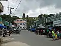 Poblacion
 Town hall
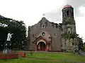 Nuestra Señora de Candelaria Parish Church
See also
References
- Municipality of Mabitac | (DILG)
- "Province: Laguna". PSGC Interactive. Quezon City, Philippines: Philippine Statistics Authority. Retrieved 12 November 2016.
- Census of Population (2015). "Region IV-A (Calabarzon)". Total Population by Province, City, Municipality and Barangay. PSA. Retrieved 20 June 2016.
- "PSA releases the 2015 Municipal and City Level Poverty Estimates". Quezon City, Philippines. Retrieved 1 January 2020.
- "Mabitac: Average Temperatures and Rainfall". Meteoblue. Retrieved 11 May 2020.
- Census of Population and Housing (2010). "Region IV-A (Calabarzon)". Total Population by Province, City, Municipality and Barangay. NSO. Retrieved 29 June 2016.
- Censuses of Population (1903–2007). "Region IV-A (Calabarzon)". Table 1. Population Enumerated in Various Censuses by Province/Highly Urbanized City: 1903 to 2007. NSO.
- "Province of Laguna". Municipality Population Data. Local Water Utilities Administration Research Division. Retrieved 17 December 2016.
External links
| Wikimedia Commons has media related to Mabitac, Laguna. |
- Mabitac Profile at PhilAtlas.com
- "Municipality of Mabitac", Province of Laguna Website
- Philippine Standard Geographic Code
- Philippine Census Information
- Local Governance Performance Management System
Places adjacent to Mabitac | ||||||||||
|---|---|---|---|---|---|---|---|---|---|---|
| ||||||||||
Santa Cruz (capital) | ||
| Municipalities |  | |
| Component Cities | ||
| Barangays | ||