Alberta Highway 61
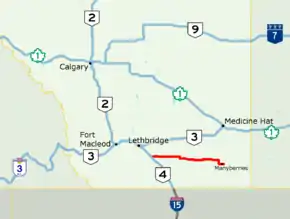
Alberta Provincial Highway No. 61, commonly referred to as Highway 61, is an east–west highway in southern Alberta, Canada. In the west, Highway 61 starts at Highway 4 north of the Village of Stirling and ends at Highway 889 east of the Hamlet of Manyberries. It is part of the Red Coat Trail, a historical route north of the Canada–US border. The Red Coat Trail continues to Saskatchewan via Highway 889 and Highway 501.[3][1]
| ||||
|---|---|---|---|---|
| Red Coat Trail | ||||
 Highway 61 highlighted in red | ||||
| Route information | ||||
| Length | 146.8 km[1] (91.2 mi) | |||
| Existed | 1960[2]–present | |||
| Major junctions | ||||
| West end | ||||
| East end | ||||
| Location | ||||
| Specialized and rural municipalities | Warner No. 5 County, Forty Mile No. 8 County | |||
| Villages | Foremost | |||
| Highway system | ||||
Provincial highways in Alberta
| ||||
History
In 1959, Alberta announced $100,000 of improvements to the highway, and incorporation of it to the provincial highway system the following year.[2] Paving was completed by 1961.[2]
Major intersections
From west to east:
| Rural/specialized municipality | Location | km[1] | mi | Destinations | Notes |
|---|---|---|---|---|---|
| County of Warner No. 5 | Stirling | 0.0 | 0.0 | Red Coat Trail follows Hwy 4 north | |
| Wrentham | 23.5 | 14.6 | |||
| County of Forty Mile No. 8 | | 52.2 | 32.4 | West end of Hwy 877 concurrency | |
| Skiff | 55.2 | 34.3 | East end of Hwy 877 concurrency | ||
| Foremost | 81.1 | 50.4 | West end of Hwy 879 concurrency | ||
| 82.7 | 51.4 | East end of Hwy 879 concurrency | |||
| Etzikom | 108.2– 108.3 | 67.2– 67.3 | Intersections offset; Hwy 885 concurrency for 110 m (360 ft) | ||
| Orion | 129.7 | 80.6 | West end of Hwy 887 concurrency | ||
| | 136.8 | 85.0 | East end of Hwy 887 concurrency | ||
| Manyberries | 146.8 | 91.2 | Red Coat Trail follows Hwy 889 south | ||
1.000 mi = 1.609 km; 1.000 km = 0.621 mi
| |||||
References
- Google (December 20, 2017). "Highway 61 in southern Alberta" (Map). Google Maps. Google. Retrieved December 20, 2017.
- "Stirling - Manyberries Road Will Be Improved". The Lethbridge Herald. April 25, 1959.
- "2015 Provincial Highway 1-216 Progress Chart" (PDF). Alberta Transportation. March 2015. Archived (PDF) from the original on April 10, 2016. Retrieved October 12, 2016.
This article is issued from Wikipedia. The text is licensed under Creative Commons - Attribution - Sharealike. Additional terms may apply for the media files.
