Alberta Highway 64
Alberta Provincial Highway No. 64[2] is an east-west highway in northern Alberta, Canada. In the west, Highway 64 begins at the Alberta/British Columbia border and ends at Highway 2 southwest of the Town of Fairview.[1][3]
| ||||
|---|---|---|---|---|
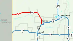 Highway 64 highlighted in red | ||||
| Route information | ||||
| Length | 126.03 km[1] (78.31 mi) | |||
| Major junctions | ||||
| West end | British Columbia border | |||
| East end | ||||
| Location | ||||
| Specialized and rural municipalities | Clear Hills County, Fairview No. 136 M.D. | |||
| Villages | Hines Creek | |||
| Highway system | ||||
Provincial highways in Alberta
| ||||

Major intersections
| Rural/specialized municipality | Location | km | mi | Destinations | Notes | ||
|---|---|---|---|---|---|---|---|
| Continues as Cecil Lake Road towards Cecil Lake and Fort St. John | |||||||
| Clear Hills County | | 0 | 0.0 | Alberta – British Columbia border | 56.316312°N 120.000000°W | ||
| | 12 | 7.5 | 56.301952°N 119.819248°W | ||||
| Cleardale | 29 | 18 | Cleardale Drive | 56.356279°N 119.490190°W | |||
| | 57 | 35 | 56.363718°N 119.134601°W | ||||
| | 84 | 52 | 56.352098°N 118.712670°W | ||||
| Hines Creek | 98 | 61 | 56.247536°N 118.590383°W | ||||
| M.D. of Fairview No. 136 | | 120 | 75 | 56.069454°N 118.496713°W | |||
| | 126 | 78 | 56.013839°N 118.496376°W | ||||
| 1.000 mi = 1.609 km; 1.000 km = 0.621 mi | |||||||
Highway 64A
| |
|---|---|
| Location | M.D. of Fairview No. 136, Town of Fairview |
| Length | 6.64 km[1] (4.13 mi) |
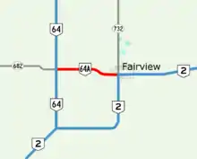
Highway 64A in Fairview, Alberta
Alberta Provincial Highway No. 64A is the designation of an alternate route off Highway 64 serving the Town of Fairview. It extends 7 km (4.3 mi) from its intersection with Highway 64/Highway 682 in the west to its intersection with Highway 2/Highway 732 within Fairview in the east.[3]
Major intersections
| Rural/specialized municipality | Location | km | mi | Destinations | Notes |
|---|---|---|---|---|---|
| M.D. of Fairview No. 136 | | 0.00 | 0.00 | 56.069454°N 118.496713°W | |
| Fairview | 6.64 | 4.13 | 56.064335°N 118.391969°W | ||
| 1.000 mi = 1.609 km; 1.000 km = 0.621 mi | |||||
References
- "Provincial Highway 1-216 Progress Chart" (PDF). Alberta Transportation. March 2015. Archived (PDF) from the original on April 10, 2016. Retrieved October 31, 2016.
- Provincial Highways Designation Order, Alberta Transportation, p. 9
- Google (October 31, 2016). "Highway 64/64A in northern Alberta" (Map). Google Maps. Google. Retrieved October 31, 2016.
This article is issued from Wikipedia. The text is licensed under Creative Commons - Attribution - Sharealike. Additional terms may apply for the media files.