Alberta Highway 6
Alberta Provincial Highway No. 6, commonly referred to as Highway 6, is a north-south highway in southern Alberta, Canada. It spans approximately 74 kilometres (46 mi) from Alberta's border with Montana to Highway 3 (Crowsnest Highway).[2][3]
| ||||
|---|---|---|---|---|
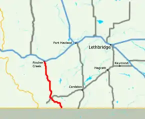 Highway 6 highlighted in red | ||||
| Route information | ||||
| Length | 73.5 km[1] (45.7 mi) | |||
| Major junctions | ||||
| South end | ||||
| North end | ||||
| Location | ||||
| Specialized and rural municipalities | I.D. No. 4, Cardston County, Pincher Creek No. 9 M.D. | |||
| Towns | Pincher Creek | |||
| Highway system | ||||
Provincial highways in Alberta
| ||||

.svg.png.webp)
Highway 6 is part of the Cowboy Trail between Highway 5 in Waterton Lakes National Park and the Crowsnest Highway, where the Cowboy Trail follows Highway 3 to Highway 22 and continues north.[4]
Route description
Montana Highway 17 in Glacier National Park becomes Alberta Highway 6 in Waterton Lakes National Park as it crosses the Canada–United States border at Chief Mountain. Generally travelling in a north direction from Chief Mountain, the highway provides access to the Hamlet of Waterton Park via Highway 5, and passes through the Hamlet of Twin Butte and the Town of Pincher Creek. Highway 6 ends at Highway 3 north of Pincher Creek.[1][3]
Major intersections
The following is a list of major intersections along Alberta Highway 6 from south to north.[2][3]
| Rural/specialized municipality | Location | km[1] | mi | Destinations | Notes |
|---|---|---|---|---|---|
| I.D. No. 4 (Waterton Lakes National Park) | Chief Mountain | 0.0 | 0.0 | Continues into Montana | |
| Canada–United States border at Chief Mountain Border Crossing | |||||
| | 22.0 | 13.7 | Hwy 6 branches west; south end of Hwy 5 concurrency | ||
| South end of Cowboy Trail | |||||
| 22.9 | 14.2 | Hwy 6 turns north; north end of Hwy 5 concurrency | |||
| M.D. of Pincher Creek No. 9 | | 49.2 | 30.6 | ||
| Pincher Creek | 69.3 | 43.1 | South end of Hwy 501 concurrency | ||
| 70.6 | 43.9 | Roundabout; Hwy 6 branches north; north end of Hwy 501 concurrency | |||
| Pincher Station | 73.5 | 45.7 | Interchange proposed[5] | ||
1.000 mi = 1.609 km; 1.000 km = 0.621 mi
| |||||
References
- Google (November 20, 2017). "Highway 6 in Alberta" (Map). Google Maps. Google. Retrieved November 20, 2017.
- "Provincial Highway 1-216 Progress Chart" (PDF). Alberta Transportation. March 2015. Archived (PDF) from the original on April 10, 2016. Retrieved October 12, 2016.
- Alberta Official Road Map (Map) (2010 ed.). Alberta Tourism, Parks and Recreation. § N-5, O-5, O-6.
- "Cowboy Trail Map". The Cowboy Trail. The Cowboy Trail Tourism Association. Retrieved July 30, 2018.
- "Highway 3/6 Interchange Functional Planning Study: Executive Summary" (PDF). Alberta Transportation. CastleGlen Consultants Inc. April 2008. Retrieved November 10, 2016.
External links
| Wikimedia Commons has media related to Alberta Highway 6. |